Items Similar to Crossroads of Continents: Spain's North African Enclaves in 1903


Want more images or videos?
Request additional images or videos from the seller
1 of 9
Crossroads of Continents: Spain's North African Enclaves in 1903
$377.16
$471.4520% Off
£284.08
£355.0920% Off
€320
€40020% Off
CA$520.12
CA$650.1520% Off
A$584.33
A$730.4120% Off
CHF 305.31
CHF 381.6420% Off
MX$7,132.02
MX$8,915.0320% Off
NOK 3,876.59
NOK 4,845.7420% Off
SEK 3,648.99
SEK 4,561.2420% Off
DKK 2,435.72
DKK 3,044.6520% Off
About the Item
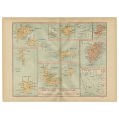
The image for sale is a historical map of Spanish possessions in North Africa, dated 1903. The map includes the enclaves of Ceuta and Melilla, the Chafarinas Islands, the Alhucemas Islands, and the Peñón de Vélez de la Gomera. These territories are located along the northern coast of Morocco and are significant due to their strategic positions at the crossroads of the Mediterranean and the Atlantic.
Ceuta and Melilla are two autonomous Spanish cities on the northern coast of Africa, bordered by Morocco. They have a complex history, shaped by their strategic military and trade positions and the cultural influences of Christians, Muslims, and Jews.
The Chafarinas Islands are an archipelago of three small islets, with Spain maintaining a garrison on one of them. Similarly, the Alhucemas Islands and the Peñón de Vélez de la Gomera are small territories under Spanish control.
These areas are known for:
1. **Military Significance**: Due to their strategic location, they have been historically significant for military control of the Mediterranean.
2. **Cultural Diversity**: The cities of Ceuta and Melilla, in particular, are known for their multicultural heritage, with Christian, Muslim, and Jewish communities coexisting.
3. **Biodiversity**: The islands, especially the Chafarinas Islands, are important for their biodiversity and are protected areas with a rich variety of birdlife and marine species.
4. **Migration Crossroads**: These enclaves are also contemporary hotspots for migration issues, as they are gateways between Africa and Europe.
- Dimensions:Height: 14.77 in (37.5 cm)Width: 20.08 in (51 cm)Depth: 0 in (0.02 mm)
- Materials and Techniques:
- Period:1900-1909
- Date of Manufacture:1903
- Condition:Good condition. Central vertical folding lines as issued. Aged paper with typically warm, yellowish-brown hue, especially around the edges and folding lines, adding to its patina. Check the images carefully.
- Seller Location:Langweer, NL
- Reference Number:Seller: BG-13642-511stDibs: LU3054338034232
About the Seller
5.0
Recognized Seller
These prestigious sellers are industry leaders and represent the highest echelon for item quality and design.
Platinum Seller
Premium sellers with a 4.7+ rating and 24-hour response times
Established in 2009
1stDibs seller since 2017
2,534 sales on 1stDibs
Typical response time: <1 hour
- ShippingRetrieving quote...Shipping from: Langweer, Netherlands
- Return Policy
Authenticity Guarantee
In the unlikely event there’s an issue with an item’s authenticity, contact us within 1 year for a full refund. DetailsMoney-Back Guarantee
If your item is not as described, is damaged in transit, or does not arrive, contact us within 7 days for a full refund. Details24-Hour Cancellation
You have a 24-hour grace period in which to reconsider your purchase, with no questions asked.Vetted Professional Sellers
Our world-class sellers must adhere to strict standards for service and quality, maintaining the integrity of our listings.Price-Match Guarantee
If you find that a seller listed the same item for a lower price elsewhere, we’ll match it.Trusted Global Delivery
Our best-in-class carrier network provides specialized shipping options worldwide, including custom delivery.More From This Seller
View AllEchoes of Empire: Spanish Territories in West Africa, 1903
Located in Langweer, NL
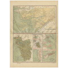
This is a historical map showing Spanish possessions in West Africa from the year 1903. The map includes the islands of Fernando Póo (now known as Bioko), part of the modern-day country of Equatorial Guinea, Annobón Island, and the Elobey Islands, along with the Spanish-controlled areas on the continental region near Rio Muni.
These territories were part of Spain's colonial empire and are situated in the Gulf of Guinea, off the coast of Central Africa. Fernando Póo (Bioko) is particularly notable for its volcanic origins and as a center of cocoa production during the colonial period. Annobón, lying further southwest of Bioko, is a small volcanic island. The Elobey Islands are very small and located near the coast of Gabon.
Here's a brief overview of their significance:
1. **Bioko Island (Fernando Póo)**: The island has a rich biodiversity and is known for its unique flora and fauna, including several endemic species. Malabo, the capital city of Equatorial Guinea, is located here.
2. **Annobón Island**: This remote island has a small population and is known for its isolation and distinctive Creole culture, which has developed independently from the mainland.
3. **Elobey Islands**: These consist of Elobey Grande and Elobey Chico and are situated near the mouths of the Muni and Campo rivers. They were historically important as transit points in river trade...
Category
Antique Early 1900s Maps
Materials
Paper
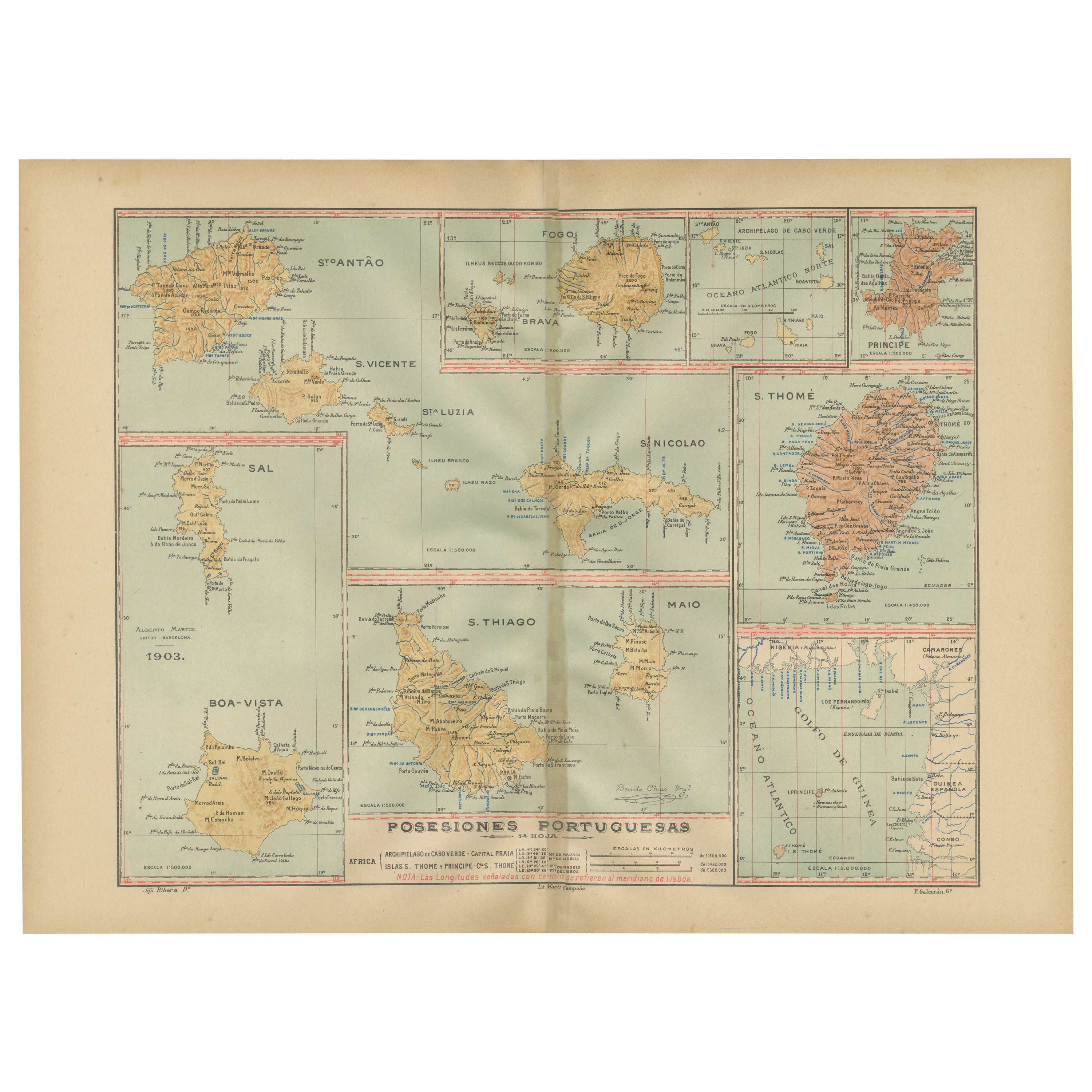
Islands of Diversity: Portugal's Atlantic Archipelagos in 1903
Located in Langweer, NL
The image is an original historical map from 1903 depicting Portuguese possessions in the Atlantic Ocean, specifically the islands of Cape Verde and the islands of São Tomé and Prínc...
Category
Antique Early 1900s Maps
Materials
Paper
Empire's Tapestry: Mapping Portugal's Global Legacy in 1903
Located in Langweer, NL
This map is an original antique map that showcases Portuguese possessions around the turn of the 20th century, with a focus on Guinea-Bissau (referred to on the map as "Guiné Portugu...
Category
Antique Early 1900s Maps
Materials
Paper
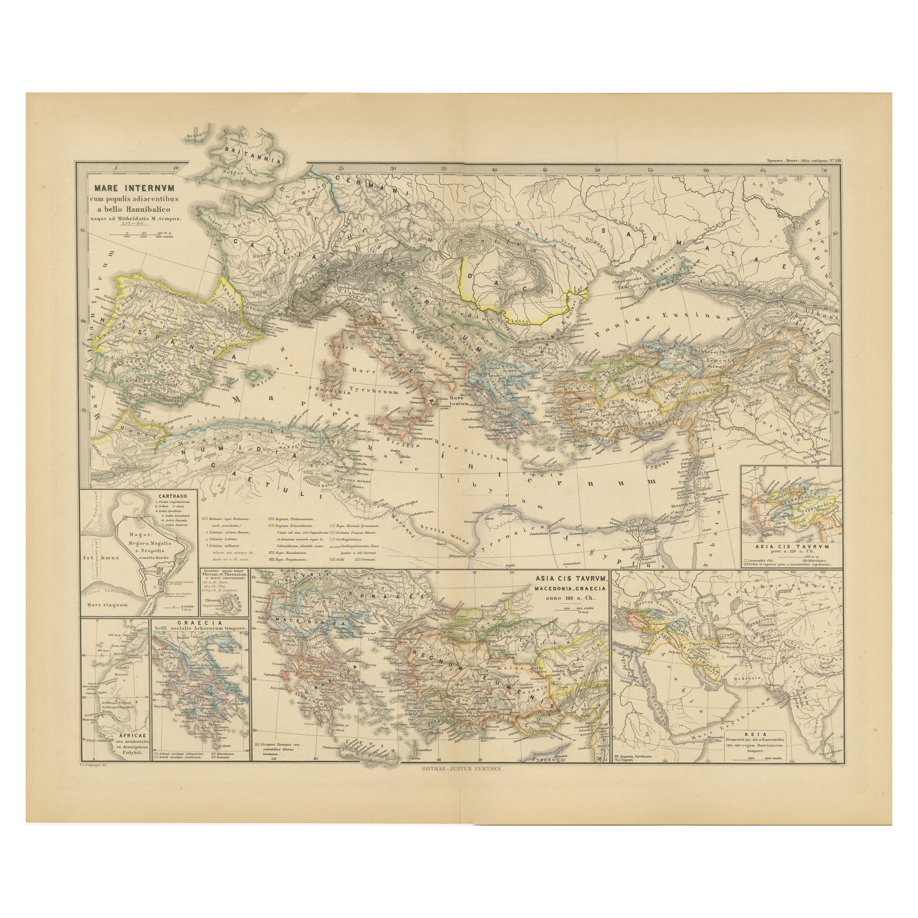
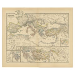
Mediterranean Encounters: From the Punic Wars to the Hannibalic War, 1880
Located in Langweer, NL
The map, with the title "MARE INTERNUM cum populis adiacentibus a bello Hannibalico usque ad Vespasiani M. princip," depicts the Mediterranean Sea and its surrounding territories, ex...
Category
Antique 1880s Maps
Materials
Paper
$348 Sale Price
20% Off
Free Shipping
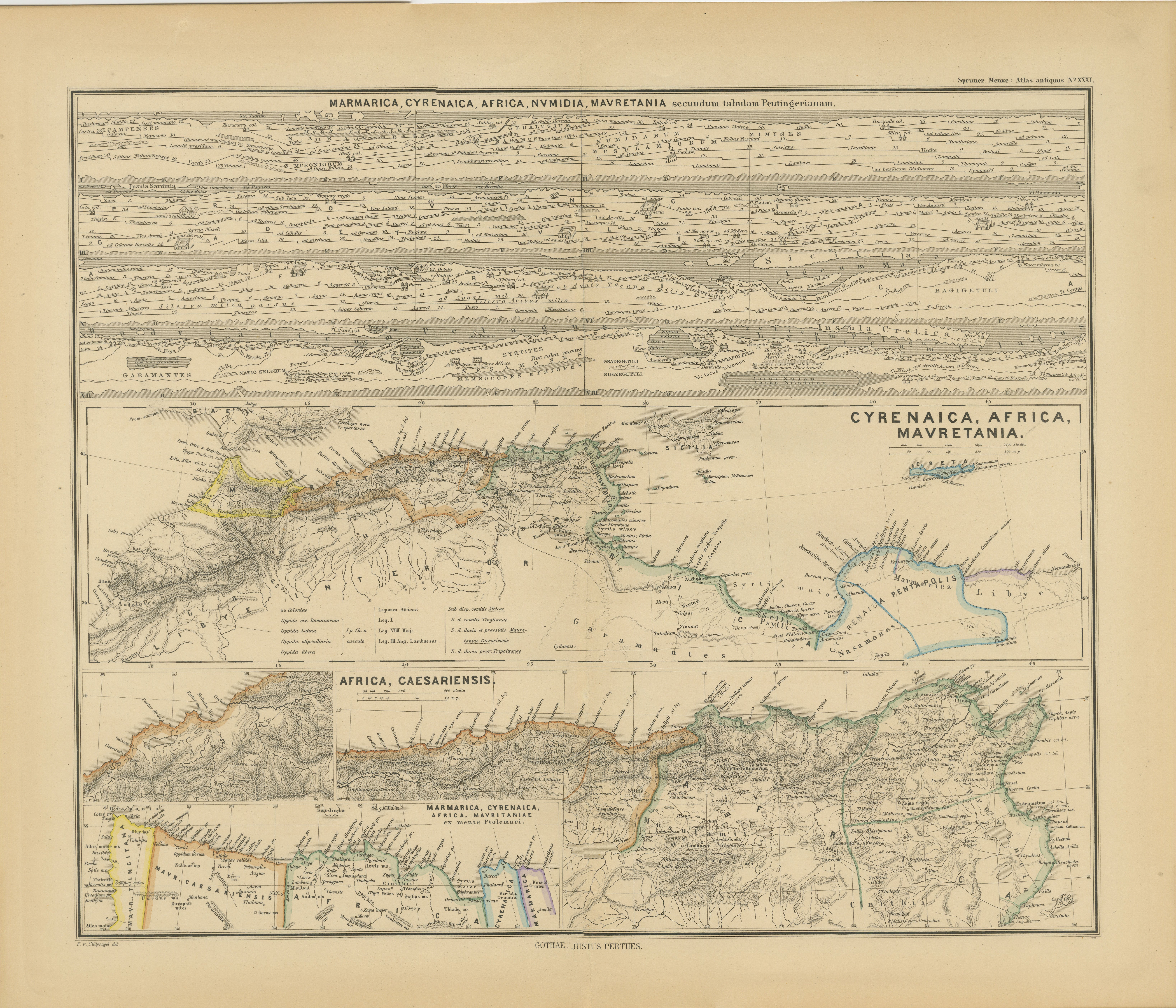
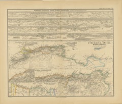
North African Coasts: Marmarica to Mauretania in Roman Times, Published in 1880
Located in Langweer, NL
The map with the title "MARMARICA, CYRENAICA, AFRICA, NUMIDIA, MAURETANIA secundum Italiam Poetarum" presents a historical geographical view of the northern coast of Africa, detailin...
Category
Antique 1880s Maps
Materials
Paper
$348 Sale Price
20% Off
Free Shipping
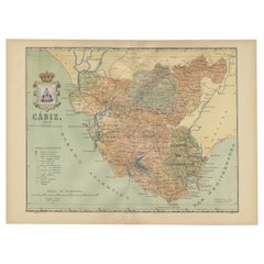
Cádiz 1901: Nautical Crossroads of the Atlantic and Mediterranean
Located in Langweer, NL
The map illustrates the province of Cádiz, located in the autonomous community of Andalusia, Spain, from the year 1901. It displays various geographic and man-made features:
The map...
Category
Antique Early 1900s Maps
Materials
Paper
$396 Sale Price
20% Off
Free Shipping
You May Also Like
Africa. North-West Part. Century Atlas antique vintage map
Located in Melbourne, Victoria
'The Century Atlas. Africa. Southern Part'
Original antique map, 1903.
Central fold as issued. Map name and number printed on the reverse corners.
Sheet 40cm by 29.5cm.
Category
Early 20th Century Victorian More Prints
Materials
Lithograph

Map Huntingdonshire R Scott Archibald Fullarton & Co Glasgow
Located in BUNGAY, SUFFOLK
Folding Map of Huntingdonshire by R Scott with distances from London and reference to the hundreds.
Published by Archibald Fullarton & Co Glasgow. Measure: 40...
Category
Antique 19th Century English Victorian Maps
Materials
Paper

Original 1891 Walker Map
Located in Norwell, MA
Original 1891 map of Massachusetts by Walker. Towns include Cambridge, Boston, Dedham, Ashland, Brookline, Newton etc... burl wood frame. Measures...
Category
Antique 19th Century Maps

Antique 1803 Italian Map of Asia Including China Indoneseia India
Located in Amsterdam, Noord Holland
Antique 1803 Italian Map of Asia Including China Indoneseia India
Very nice map of Asia. 1803.
Additional information:
Type: Map
Country of Manufacturing: Europe
Period: 19th centu...
Category
Antique 19th Century European Maps
Materials
Paper

$584 Sale Price
20% Off
Africa. North-East Part. Century Atlas antique vintage map
Located in Melbourne, Victoria
'The Century Atlas. Africa. North-East Part'
Original antique map, 1903.
Inset map of 'Nile Delta and Suez Canal'.
Central fold as issued. Map name and nu...
Category
Early 20th Century Victorian More Prints
Materials
Lithograph

Ancient National Atlas of France with Marengo
Located in Alessandria, Piemonte
Ancient National Atlas of France with the department of Marengo: a rare French etching dated 1806.
ST/178.
Category
Antique Early 19th Century French Other Prints
Materials
Paper

More Ways To Browse
Moroccan Jewish
Jewish Morocco Antique
Early American Chairs
Hans Muller
Vintage Wood Table With Glass Top
19th Century Square Table
Antonio Bonet
Galle Chairs
Large Chinese Rug
1940s Vintage French Art Deco
20th Century Spanish Table
Antonio Bellini
Retro Fiberglass Furniture
Shipping Crate
Antique Oushak Carpets
Blue Coffee Tables
German Bauhaus Posters
1945 Chair Juhl