Items Similar to Detailed Antique Map of Asia Minor & Cyprus with Historical Notes, 1732


Want more images or videos?
Request additional images or videos from the seller
1 of 5
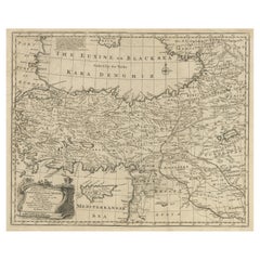
Detailed Antique Map of Asia Minor & Cyprus with Historical Notes, 1732
$239.84
$299.7920% Off
£178.41
£223.0220% Off
€200
€25020% Off
CA$328.42
CA$410.5220% Off
A$365.16
A$456.4420% Off
CHF 190.66
CHF 238.3320% Off
MX$4,444.83
MX$5,556.0420% Off
NOK 2,432.79
NOK 3,040.9920% Off
SEK 2,279.41
SEK 2,849.2620% Off
DKK 1,522.49
DKK 1,903.1120% Off
Shipping
Retrieving quote...The 1stDibs Promise:
Authenticity Guarantee,
Money-Back Guarantee,
24-Hour Cancellation
About the Item
Antique map titled 'Carte De L'Asie Inferieure Selon Les Auteurs Anciens (..)'. Detailed map of Asia Minor & Cyprus. With historical notes. This original old antique print / plate originates from the fifth volume of: 'Atlas Historique...' (Historic Atlas...), Published by Zacharie Chatelain, Amsterdam, 1732. The atlas was published in seven volumes between 1705 and 1720, with a second edition appearing in 1732. The maps were accompanied by information pertaining to cosmography, geography, history, chronology, genealogy, topography, heraldry, and costumes of the world. The maps in the Atlas Historique were mainly based on those of the French cartographer, Guillaume De L'Isle, but were presented by the Chatelains in an encyclopaedic form.
Artists and Engravers: Henri Abraham Chatelain (1684-1743), his father Zacharie Chatelain (d.1723) and Zacharie Junior (1690-1754), worked as a partnership publishing the Atlas Historique, Ou Nouvelle Introduction A L'Histoire under several different Chatelain imprints, depending on the Chatelain family partnerships at the time of publication.
Condition: Good, general age-related toning. Please study image carefully.
Date: 1732
Overall size: 56.5 x 48 cm.
Image size: 0.001 x 44 x 38 cm.
We sell original antique maps to collectors, historians, educators and interior decorators all over the world. Our collection includes a wide range of authentic antique maps from the 16th to the 20th centuries. Buying and collecting antique maps is a tradition that goes back hundreds of years. Antique maps have proved a richly rewarding investment over the past decade, thanks to a growing appreciation of their unique historical appeal. Today the decorative qualities of antique maps are widely recognized by interior designers who appreciate their beauty and design flexibility. Depending on the individual map, presentation, and context, a rare or antique map can be modern, traditional, abstract, figurative, serious or whimsical. We offer a wide range of authentic antique maps for any budget.
- Dimensions:Height: 18.9 in (48 cm)Width: 22.25 in (56.5 cm)Depth: 0 in (0.01 mm)
- Materials and Techniques:
- Period:
- Date of Manufacture:1732
- Condition:
- Seller Location:Langweer, NL
- Reference Number:Seller: PCT-132081stDibs: LU3054326091542
About the Seller
5.0
Recognized Seller
These prestigious sellers are industry leaders and represent the highest echelon for item quality and design.
Platinum Seller
Premium sellers with a 4.7+ rating and 24-hour response times
Established in 2009
1stDibs seller since 2017
2,511 sales on 1stDibs
Typical response time: <1 hour
- ShippingRetrieving quote...Shipping from: Langweer, Netherlands
- Return Policy
Authenticity Guarantee
In the unlikely event there’s an issue with an item’s authenticity, contact us within 1 year for a full refund. DetailsMoney-Back Guarantee
If your item is not as described, is damaged in transit, or does not arrive, contact us within 7 days for a full refund. Details24-Hour Cancellation
You have a 24-hour grace period in which to reconsider your purchase, with no questions asked.Vetted Professional Sellers
Our world-class sellers must adhere to strict standards for service and quality, maintaining the integrity of our listings.Price-Match Guarantee
If you find that a seller listed the same item for a lower price elsewhere, we’ll match it.Trusted Global Delivery
Our best-in-class carrier network provides specialized shipping options worldwide, including custom delivery.More From This Seller
View AllAntique Map of the Eastern Mediterranean, C.1710
Located in Langweer, NL
Antique map Middle East titled 'De Beschryving van de Reysen Pauli en van de Andere Apostelen'. Antique map of the Eastern Mediterranean with det...
Category
Antique 18th Century Maps
Materials
Paper

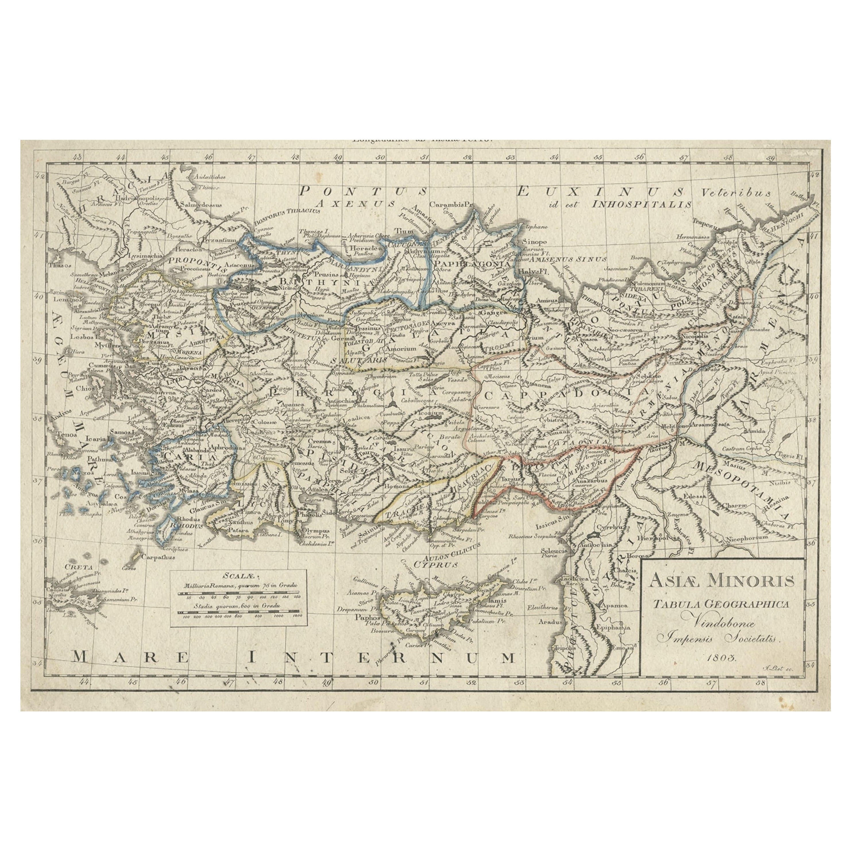
Antique Map of Asia Minor, Present-day Turkey and Cyprus, 1803
Located in Langweer, NL
Antique map titled 'Asiae Minoris Tabula Geographica'. Uncommon antique map of Asia minor, comprising most of what is present-day Turkey. Source unknown, to be determined.
Artists...
Category
Antique 19th Century Maps
Materials
Paper
$172 Sale Price
20% Off
Antique Map of Eastern Mediterranean and Asia Minor by a Benedictine, c.1725
Located in Langweer, NL
Antique map titled 'Byzondere Afbeelding der Landschappen, van de Apostelen bevaren en doorwandelt om het Evangelium J. C. te Prediken.' Map of the lands travelled by the Apostles to...
Category
Antique 18th Century Maps
Materials
Paper

$287 Sale Price
20% Off
Antique Map of Greece, Albania, Macedonia and Parts of Turkey and Cyprus, c.1745
Located in Langweer, NL
Antique map titled 'Accurata Totius Archipelagi Et Graeciae Universae Tabula'.
Detailed map of Greece. Includes Albania, Macedonia and parts of Turkey and Cyprus. With compass rose...
Category
Antique 18th Century Maps
Materials
Paper

$815 Sale Price
20% Off
Antique Map of Turkey in Europe, c.1780
Located in Langweer, NL
Antique map titled 'Bowles's new pocket map of Turky in Europe divided into its Provinces'. Large map of Turkey in Europe. Source unknown, to be determined.
Artists and Engravers: Made by 'Thomas & Carington Bowles' after an anonymous artist. Thomas Bowles, born around 1712, was map publisher and seller in London...
Category
Antique 18th Century Maps
Materials
Paper
$345 Sale Price
20% Off
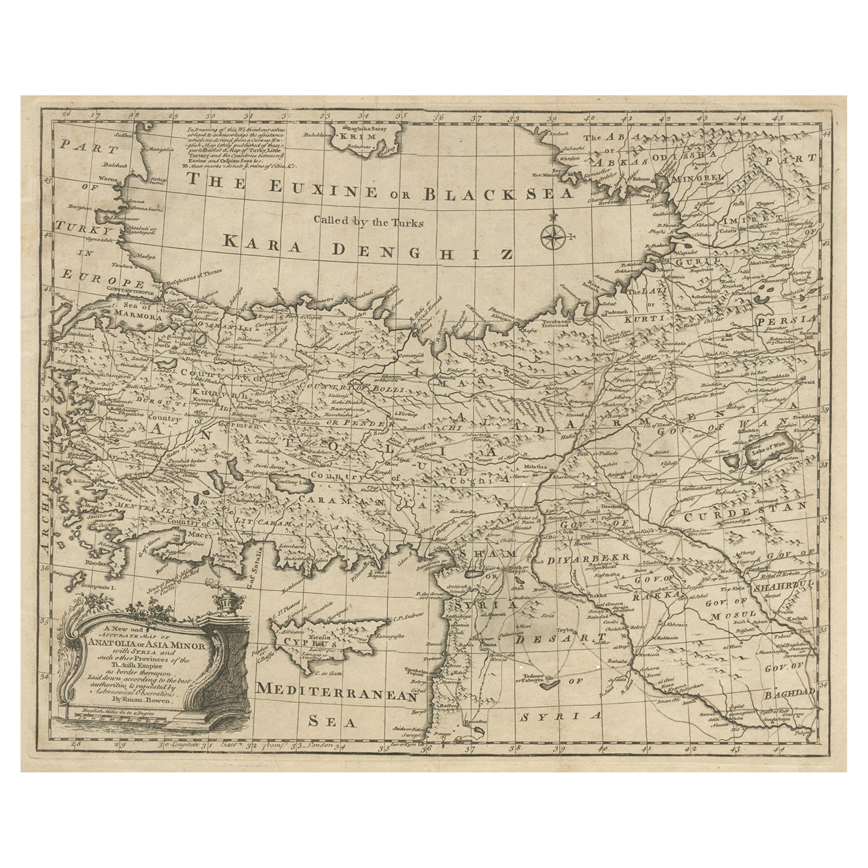
Antique Map of Asia Minor with Cyprus, Syria and Turkey and the Black Sea, 1747
Located in Langweer, NL
Antique map Middle East titled 'A New and accurate map of Anatolia or Asia Minor, with Syria and such other provinces of the Turkish Empire (.....
Category
Antique 18th Century Maps
Materials
Paper
$431 Sale Price
20% Off
You May Also Like
Original Antique Map of Ancient Greece, Achaia, Corinth, 1786
Located in St Annes, Lancashire
Great map of Ancient Greece. Showing the region of Thessaly, including Mount Olympus
Drawn by J.D. Barbie Du Bocage
Copper plate engraving by P.F Tardieu
Original hand color...
Category
Antique 1780s French Other Maps
Materials
Paper

Original Antique Map of Ancient Greece- Boeotia, Thebes, 1787
Located in St Annes, Lancashire
Great map of Ancient Greece. Showing the region of Boeotia, including Thebes
Drawn by J.D. Barbie Du Bocage
Copper plate engraving by P.F T...
Category
Antique 1780s French Other Maps
Materials
Paper

Southern Greece: A Large 17th C. Hand-colored Map by Sanson and Jaillot
By Nicolas Sanson
Located in Alamo, CA
This large original hand-colored copperplate engraved map of southern Greece and the Pelopponese Peninsula entitled "La Moree Et Les Isles De Zante, Cefalonie, Ste. Marie, Cerigo & C...
Category
Antique 1690s French Maps
Materials
Paper

Hand-Colored 18th Century Homann Map of the Black Sea, Turkey and Asia Minor
By Johann Baptist Homann
Located in Alamo, CA
An attractive original early 18th century hand-colored map of the Black Sea and Turkey entitled "Carte de L'Asie Minevre ou de la Natolie et du Pont Evxin Tiree des Voyages et des Ob...
Category
Antique Early 18th Century German Maps
Materials
Paper

1718 Ides & Witsen Map "Route D'amsterdam a Moscow Et De La Ispahan Et Gamron
Located in Norton, MA
1718 Ides & Witsen map, entitled
"Route D'Amsterdam A Moscow Et De La Ispahan Et Gamron,"
Ric.b005
Subject: Eastern Europe and Central Asia
Period: 1718 (published)
Publicati...
Category
Antique Early 18th Century Dutch Maps
Materials
Paper

Greece, "Graeciae Antiquae"" A 17th Century Hand-colored Map by Sanson
By Nicolas Sanson
Located in Alamo, CA
This is an original 17th century hand colored copperplate engraved map of Greece entitled "Graeciae Antiquae Tabula Hanc Geographicam" by Nicolas d'Abbeville Sanson, engraved and pub...
Category
Antique Mid-17th Century French Maps
Materials
Paper

More Ways To Browse
Antique Furniture Cyprus
Cyprus Antique Maps
Birds Eye View Map
Old School Maps
Joan Blaeu
Antique Nautical Maps
Antique Portuguese Plates
Antique Maps California
New Zealand Map
Antique Railroad Collectibles
Blaeu World Map
Roman Empire Map
Antique Map Of Middle East
Caribbean Map
Antique Map Of Egypt
Antique Map Ortelius
Antique Farm Antiques Collectibles
Antique Galleon