Items Similar to Dutch Map and City Plan of La Roche-sur-Foron, France, 17th Century Hand Colored


Want more images or videos?
Request additional images or videos from the seller
1 of 9
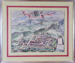
Dutch Map and City Plan of La Roche-sur-Foron, France, 17th Century Hand Colored
$1,675
£1,278.85
€1,477.71
CA$2,351.38
A$2,620.86
CHF 1,375.08
MX$32,004.99
NOK 17,411.45
SEK 16,456.47
DKK 11,028.76
About the Item
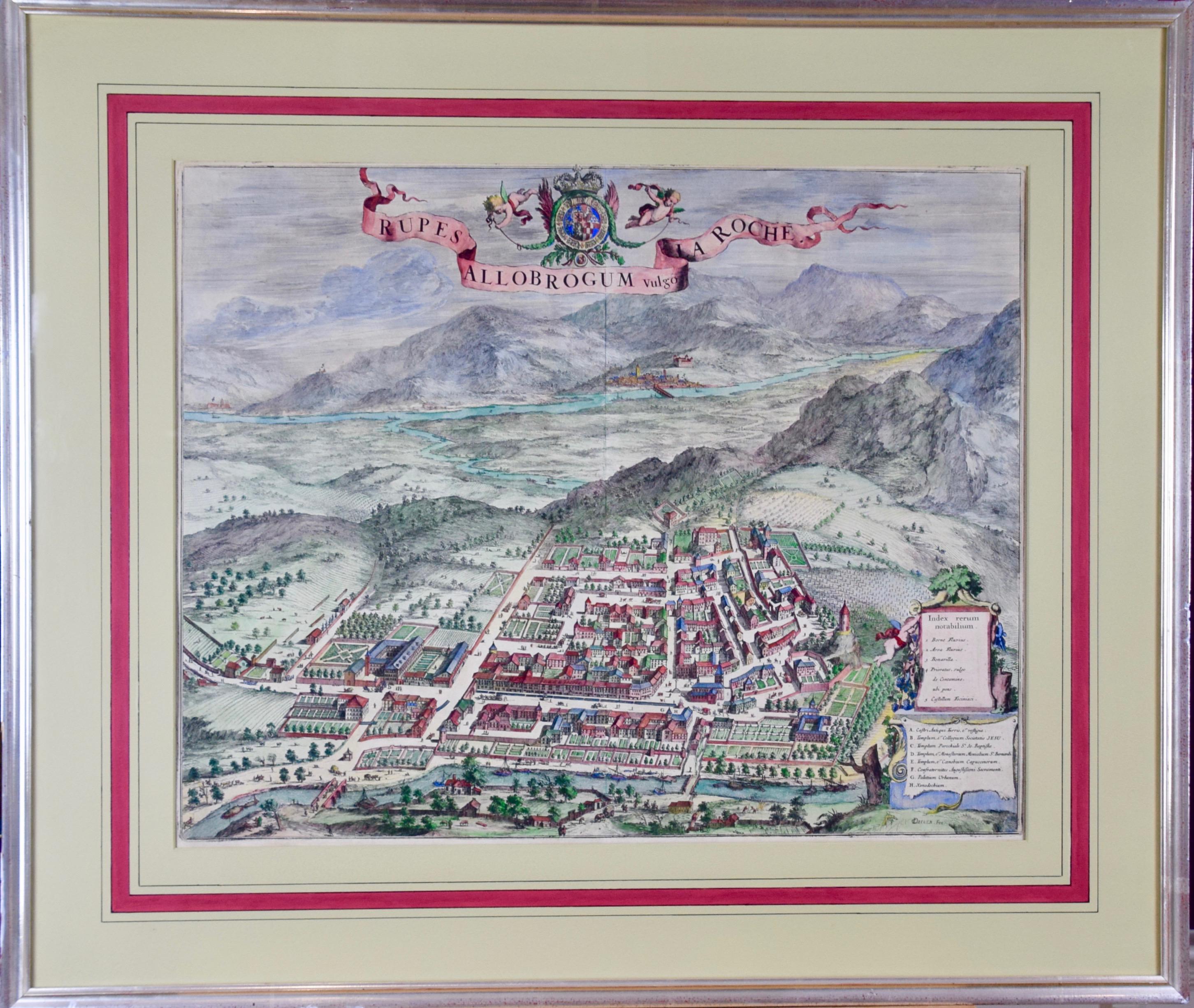
"Rupes Allobrogum vulgo La Roche" by Dutch engraver Coenraet Decker (1650-1685) is from the atlas Theatrum Statuum Regiae Celestudinis Sabaudiae Ducis, published in 1682. This richly hand colored engraving represents a bird's-eye view of the city plan of La Roche-sur-Foron, originally presented in Johannes Blaeu's (1599-1673) Theatrum Civitatum et Admirandorum Italiae (Town Book of Italy), depicting city views of Italy's Savoy and Piedmont regions. The town of La Roche was, at the time this view was created, a part of Italy, but the Savoy region was annexed by France in 1792.
The double-page extensively colored engraving's title is displayed on flowing ornamental streamers, as would be found waving from an ancient knight's lance. Putti flank a colorful coat of arms. It is presented in a silver frame with a hand colored pale green French mat with a cranberry-colored highlight band. There is a vertical center fold, as issued. The map is in excellent condition. There are small abrasions and chips to the frame.
Provenance: Thomas J. Perkins (1932-2016), San Francisco, and Belvedere, CA, was the Co-Founder Kleiner Perkins & Byers Venture Capital and often referred to as the father of Silicon Valley. He was on the Board of Directors of Hewlett-Packard, Genentech, Compaq, Applied Materials, Philips Electronics, Corning Glass and News Corp. and served as chairman of Tandem Computers and Genentech.
- Creator:Coenraet Decker (Artist)
- Dimensions:Height: 27.75 in (70.49 cm)Width: 32.5 in (82.55 cm)Depth: 0.07 in (1.78 mm)
- Materials and Techniques:Paper,Engraved
- Place of Origin:
- Period:Late 17th Century
- Date of Manufacture:1682
- Condition:Wear consistent with age and use.
- Seller Location:Alamo, CA
- Reference Number:Seller: # 32571stDibs: LU5206220652512
About the Seller
5.0
Vetted Professional Seller
Every seller passes strict standards for authenticity and reliability
1stDibs seller since 2020
15 sales on 1stDibs
- ShippingRetrieving quote...Shipping from: Alamo, CA
- Return Policy
Authenticity Guarantee
In the unlikely event there’s an issue with an item’s authenticity, contact us within 1 year for a full refund. DetailsMoney-Back Guarantee
If your item is not as described, is damaged in transit, or does not arrive, contact us within 7 days for a full refund. Details24-Hour Cancellation
You have a 24-hour grace period in which to reconsider your purchase, with no questions asked.Vetted Professional Sellers
Our world-class sellers must adhere to strict standards for service and quality, maintaining the integrity of our listings.Price-Match Guarantee
If you find that a seller listed the same item for a lower price elsewhere, we’ll match it.Trusted Global Delivery
Our best-in-class carrier network provides specialized shipping options worldwide, including custom delivery.More From This Seller
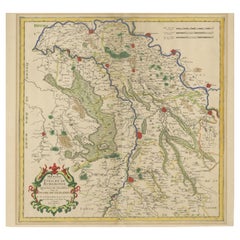
View All17th Century Hand Colored Map of the Liege Region in Belgium by Visscher
By Nicolaes Visscher II
Located in Alamo, CA
An original 17th century map entitled "Leodiensis Episcopatus in omnes Subjacentes Provincias distincté divisusVisscher, Leodiensis Episcopatus" by Nicolaes Visscher II, published in Amsterdam in 1688. The map is centered on Liege, Belgium, includes the area between Antwerp, Turnhout, Roermond, Cologne, Trier and Dinant.
This attractive map is presented in a cream-colored mat measuring 30" wide x 27.5" high. There is a central fold, as issued. There is minimal spotting in the upper margin and a tiny spot in the right lower margin, which are under the mat. The map is otherwise in excellent condition.
The Visscher family were one of the great cartographic families of the 17th century. Begun by Claes Jansz Visscher...
Category
Antique Late 17th Century Dutch Maps
Materials
Paper

Hand Colored 17th Century Visscher Map "Hollandiae" Southern Holland
By Nicolaes Visscher II
Located in Alamo, CA
A hand colored 17th century map of the southern portions of Holland by Nicolaus (Nicolas) Visscher II entitled "Hollandiae pars Meridionalis, vulgo Zuyd-Holland", published in Amsterdam in 1678. The map shows the region between Breda, Heusden, Gornichem, Gouda, Dordrecht, and Willemstad. It includes a decorative cartouche in the lower left corner.
The map is presented in an attractive maple colored wood frame with gold trim and a fabric mat.
The Visscher family were one of the great cartographic families of the 17th century. Begun by Claes Jansz Visscher...
Category
Antique Early 18th Century Dutch Maps
Materials
Paper

Vienna, Austria: A Large 17th Century Hand-Colored Map by Sanson and Jaillot
By Nicolas Sanson
Located in Alamo, CA
This large 17th century hand-colored map of Vienna, Austria and the surrounding countryside and villages entitled "Plan de la Ville de Vienne en Austrich...
Category
Antique 1690s French Maps
Materials
Paper

Prussia, Poland, N. Germany, Etc: A Hand-colored 17th Century Map by Janssonius
By Johannes Janssonius
Located in Alamo, CA
This is an attractive hand-colored copperplate engraved 17th century map of Prussia entitled "Prussia Accurate Descripta a Gasparo Henneberg Erlichensi", published in Amsterdam by Joannes Janssonius in 1664. This very detailed map from the golden age of Dutch cartography includes present-day Poland, Latvia, Lithuania, Estonia and portions of Germany. This highly detailed map is embellished by three ornate pink, red, mint green and gold...
Category
Antique Mid-17th Century Dutch Maps
Materials
Paper

17th Century Hand-Colored Map of a Region in West Germany by Janssonius
By Johannes Janssonius
Located in Alamo, CA
This attractive highly detailed 17th century original hand-colored map is entitled "Archiepiscopatus Maghdeburgensis et Anhaltinus Ducatus cum terris adjacentibus". It was published ...
Category
Antique Mid-17th Century Dutch Maps
Materials
Paper

Northern Scotland: A 17th Century Hand-colored Map by Mercator
By Gerard Mercator
Located in Alamo, CA
This is a framed hand-colored 17th century map of Northern Scotland by Gerard Mercator entitled "Scotiae pars Septentrionalis", published in Amsterdam in 1636. It is a highly detailed map of the northern part of Scotland, with the northwest Highlands and the cities Inverness and Aberdeen, as well as the Orkney Islands and the Hebrides. There is a decorative title cartouche in the upper left corner.
The map is presented in an antiqued brown wood...
Category
Antique 1630s Dutch Maps
Materials
Paper

You May Also Like
Dutch Map and City Plan of La Roche-sur-Foron, France, 17th Century Hand Colored
By Coenraet Decker
Located in Alamo, CA
"Rupes Allobrogum vulgo La Roche" by Dutch engraver Coenraet Decker (1650-1685) is from the atlas Theatrum Statuum Regiae Celestudinis Sabaudiae Ducis, published in 1682. This richly...
Category
1680s Prints and Multiples
Materials
Engraving
1571-1638 Willem Blaeu map entitled, "Ilcadorino, " Hand Colored Ric0009
Located in Norton, MA
Willem Blaeu map entitled,
"Ilcadorino,".
Hand colored.
Description: large, unusual, and nice antique copper engraved map of Ilcadorino, by Willem BL...
Category
Antique 16th Century Dutch Maps
Materials
Paper

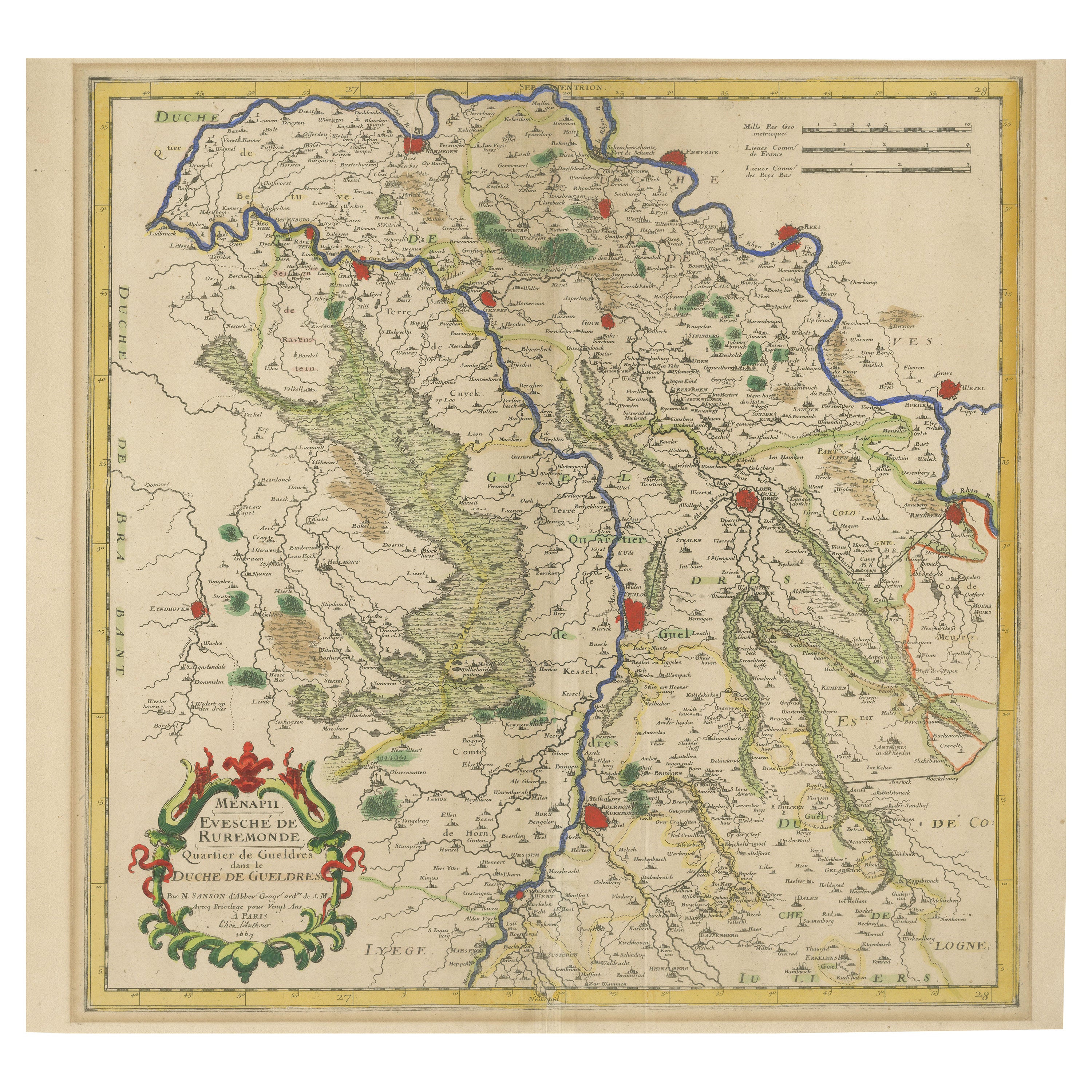
Antique Map of Roermond & Duchy of Guelders by Sanson – Hand-Colored, c.1667
Located in Langweer, NL
Antique map of Roermond and the Duchy of Guelders with rich detail, c.1667
This beautifully hand-colored 17th-century map presents the region of Roermond and the broader Duchy of Gu...
Category
Antique Late 17th Century French Maps
Materials
Paper
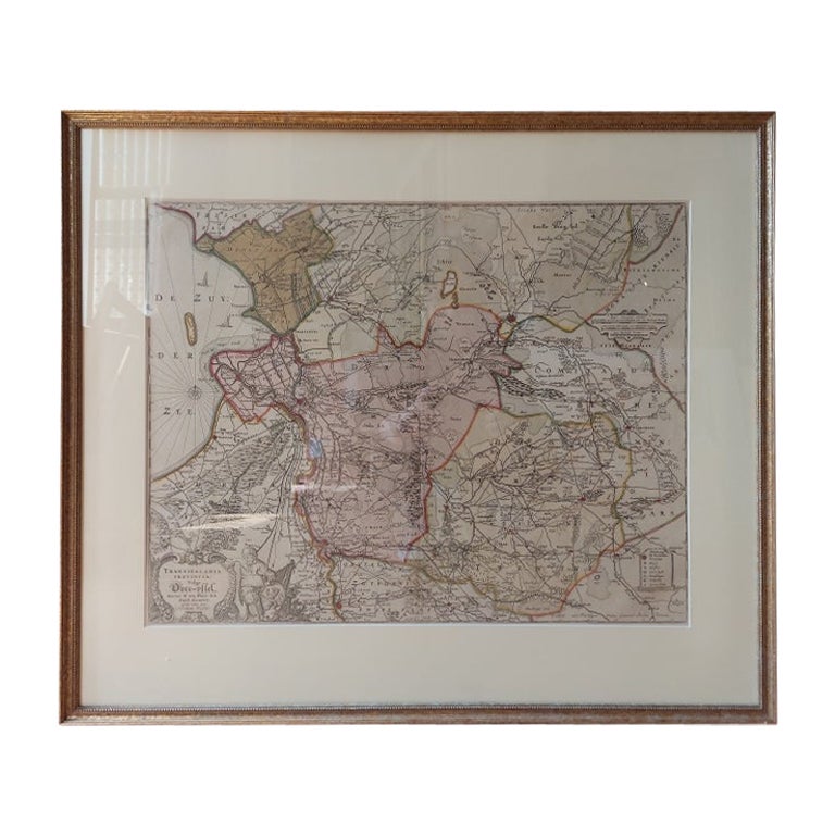
Antique Map of Overijssel by Visscher, c.1660
Located in Langweer, NL
Antique map titled 'Transisalania provincia vulgo Over-yssel'. Original antique map of the province of Overijssel, the Netherlands. Published by N. Visscher after N. ten Have, circa ...
Category
Antique 17th Century Maps
Materials
Paper

$696 Sale Price
20% Off
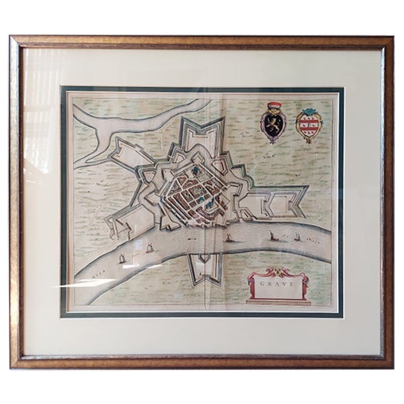
Antique Map of the City of Grave by Blaeu, 1649
Located in Langweer, NL
Antique map titled 'Grave'. Original antique map of the city of Grave, the Netherlands. Published by J. Blaeu, 1649.
Artists and Engravers: Joan Blaeu (23 September 1596 - 28 May...
Category
Antique 17th Century Maps
Materials
Paper

$660 Sale Price
20% Off
Antique Map of Douai 'France' by Braun & Hogenberg, circa 1575
Located in Langweer, NL
Beautiful map in excellent condition. This map depicts the city of Douai (France) and originates from 'Civitates Orbis Terrarum'.
Category
Antique 16th Century Maps
Materials
Paper

More Ways To Browse
Corning Glass
Dutch Engraved Glass
17th Century Dutch Silver
Dutch Green Glass
French 17th Century Silver
Birds Eye View Map
Double Decker
Savoy Silver
Antique Compass Map
Blaeu Maps
Antique Collectables Australia
Military Map
Antique Maps Scotland
Mississippi Antique
Denmark Map
Antique Maps Of North America
Wine Map
Map Greece