Items Similar to Eason's War Map of Europe, circa 1914


Want more images or videos?
Request additional images or videos from the seller
1 of 7
Eason's War Map of Europe, circa 1914
$519.84
$649.8020% Off
£389.65
£487.0620% Off
€440
€55020% Off
CA$714.17
CA$892.7120% Off
A$797.30
A$996.6320% Off
CHF 417.78
CHF 522.2220% Off
MX$9,759.79
MX$12,199.7320% Off
NOK 5,305.75
NOK 6,632.1920% Off
SEK 5,002.65
SEK 6,253.3120% Off
DKK 3,349.44
DKK 4,186.8020% Off
Shipping
Retrieving quote...The 1stDibs Promise:
Authenticity Guarantee,
Money-Back Guarantee,
24-Hour Cancellation
About the Item
Antique map titled 'Eason's War Map of Europe'. Printed in Ireland. Source unknown, to be determined.
Artists and Engravers: Anonymous.
Condition: Good, age-related toning. Minor defects, please study image carefully.
Date: circa 1914
Overall size: 62 x 47.5 cm.
Image size: 57 x 39 cm.
We sell original antique maps to collectors, historians, educators and interior decorators all over the world. Our collection includes a wide range of authentic antique maps from the 16th to the 20th centuries. Buying and collecting antique maps is a tradition that goes back hundreds of years. Antique maps have proved a richly rewarding investment over the past decade, thanks to a growing appreciation of their unique historical appeal. Today the decorative qualities of antique maps are widely recognized by interior designers who appreciate their beauty and design flexibility. Depending on the individual map, presentation, and context, a rare or antique map can be modern, traditional, abstract, figurative, serious or whimsical. We offer a wide range of authentic antique maps for any budget.
- Dimensions:Height: 18.71 in (47.5 cm)Width: 24.41 in (62 cm)Depth: 0 in (0.01 mm)
- Materials and Techniques:
- Period:
- Date of Manufacture:c.1914
- Condition:Condition: Good, age-related toning. Minor defects, please study image carefully.
- Seller Location:Langweer, NL
- Reference Number:Seller: BG-113551stDibs: LU3054329625802
About the Seller
5.0
Recognized Seller
These prestigious sellers are industry leaders and represent the highest echelon for item quality and design.
Platinum Seller
Premium sellers with a 4.7+ rating and 24-hour response times
Established in 2009
1stDibs seller since 2017
2,511 sales on 1stDibs
Typical response time: <1 hour
- ShippingRetrieving quote...Shipping from: Langweer, Netherlands
- Return Policy
Authenticity Guarantee
In the unlikely event there’s an issue with an item’s authenticity, contact us within 1 year for a full refund. DetailsMoney-Back Guarantee
If your item is not as described, is damaged in transit, or does not arrive, contact us within 7 days for a full refund. Details24-Hour Cancellation
You have a 24-hour grace period in which to reconsider your purchase, with no questions asked.Vetted Professional Sellers
Our world-class sellers must adhere to strict standards for service and quality, maintaining the integrity of our listings.Price-Match Guarantee
If you find that a seller listed the same item for a lower price elsewhere, we’ll match it.Trusted Global Delivery
Our best-in-class carrier network provides specialized shipping options worldwide, including custom delivery.More From This Seller
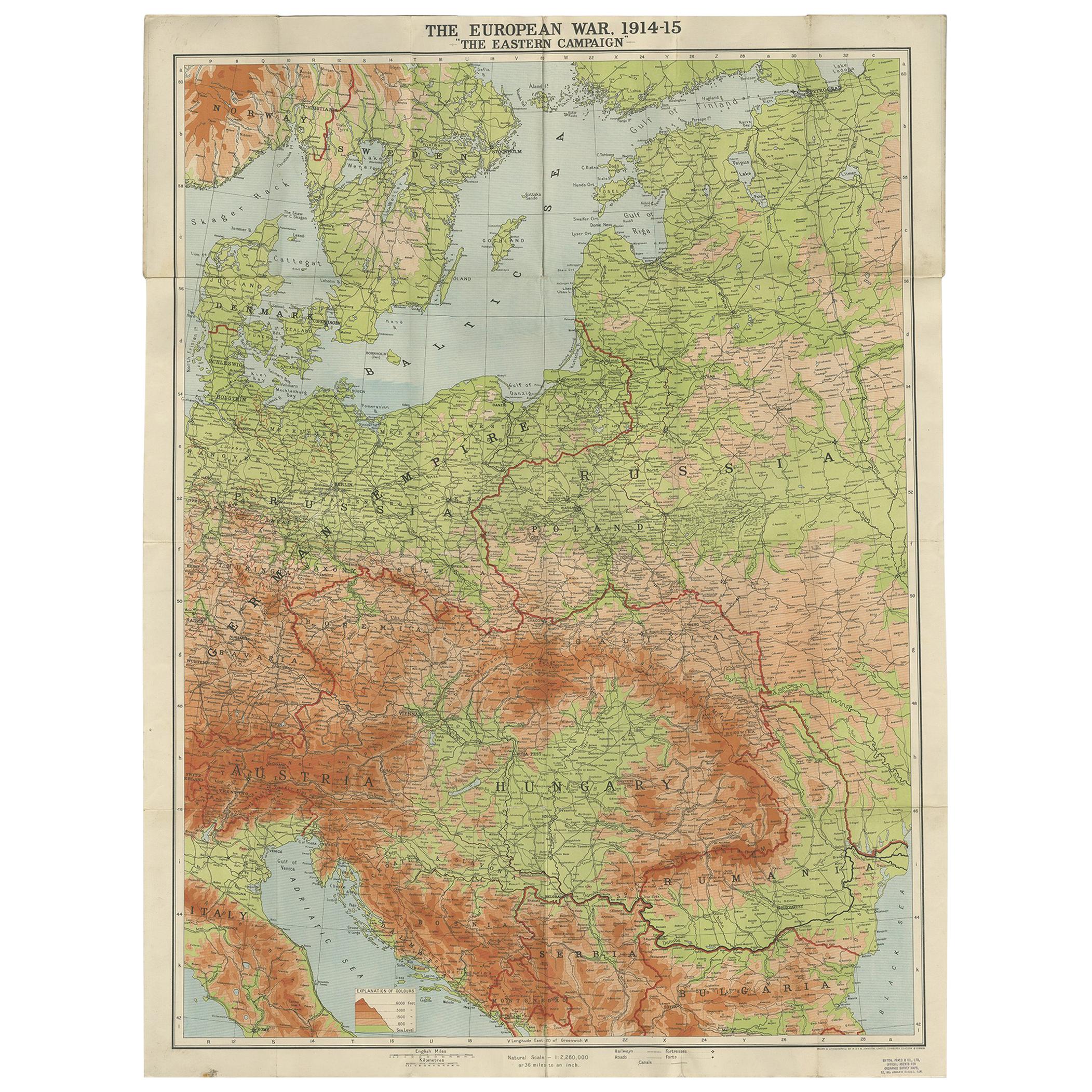
View AllAntique European War Folding Map, ‘circa 1915’
Located in Langweer, NL
Antique folding map of the European War (1914-1915) titled 'The Eastern Campaign '. From Petrograd to Berlin, geographically colored. Published on linen b...
Category
Early 20th Century Maps
Materials
Paper
$708 Sale Price
20% Off
Antique Map of Europe, 1903, with Intricate Political Boundaries and Rich Detail
Located in Langweer, NL
Title: Antique Map of Europe, 1903, with Intricate Political Boundaries and Rich Detail
Description:
This antique map, titled "Europe," is a finely engraved and beautifully colored ...
Category
Early 20th Century Maps
Materials
Paper

Antique Map of the European Continent, 1882
Located in Langweer, NL
Antique map titled 'Europe'. Old map of the European continent. This map originates from 'The Royal Atlas of Modern Geography, Exhibiting, in a Series of ...
Category
Antique 19th Century Maps
Materials
Paper

$127 Sale Price
20% Off
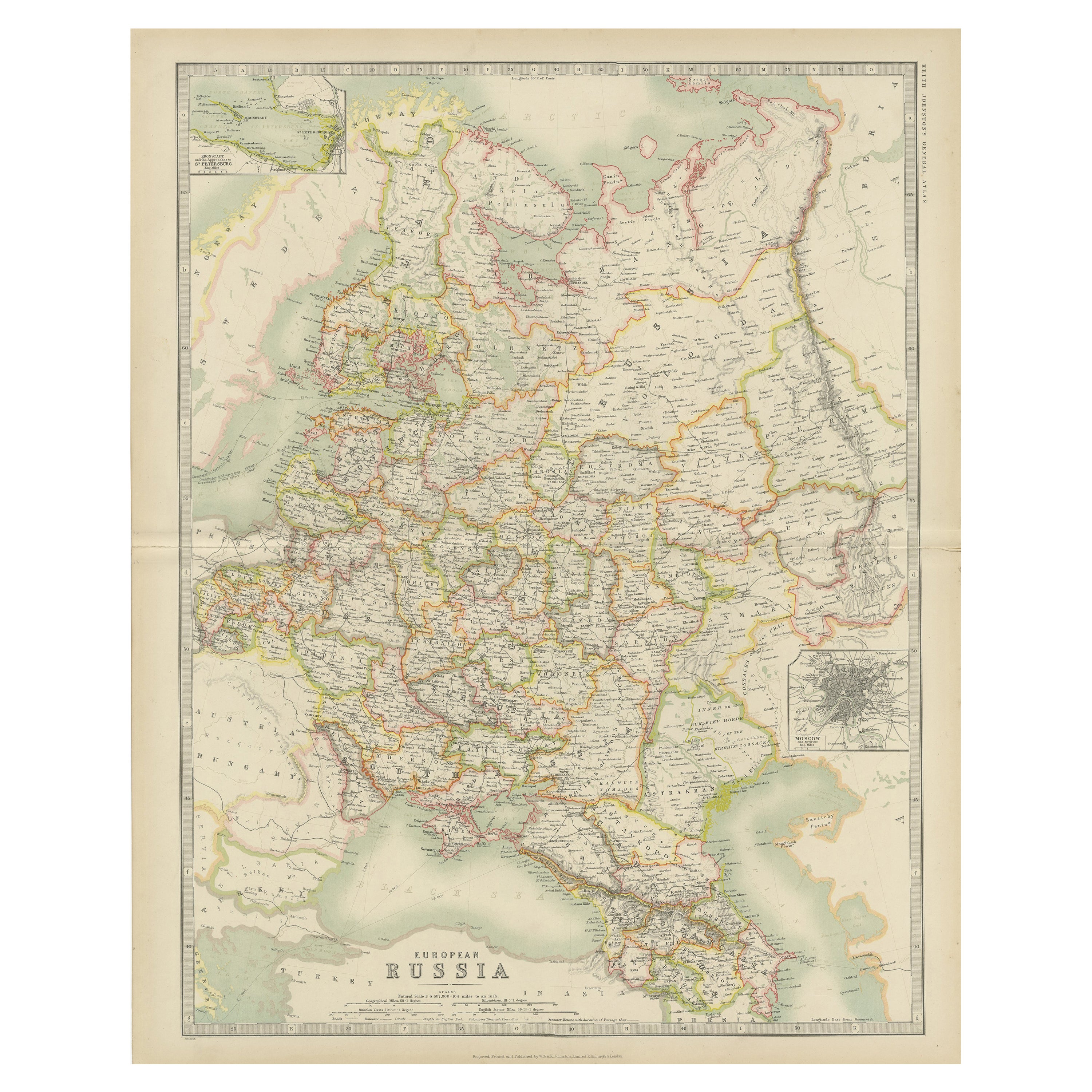
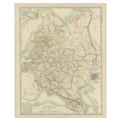
Antique Map of Russia in Europe by Johnston (1909)
Located in Langweer, NL
Antique map titled 'European Russia'. Original antique map of Russia in Europe. With inset maps of St Petersburg and Moscow. This map originates from the ‘Royal Atlas of Modern Geogr...
Category
Early 20th Century Maps
Materials
Paper
$236 Sale Price
20% Off
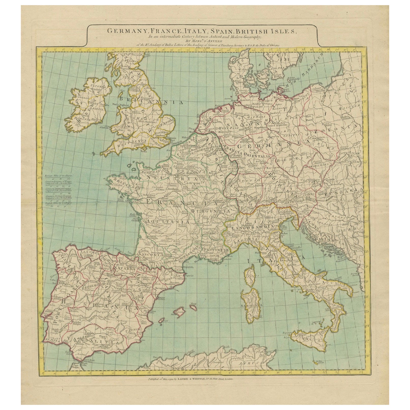
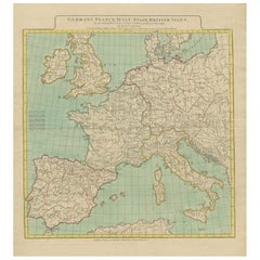
Map of Europe Highlighting Ancient and Modern Geographical Divisions (1794)
Located in Langweer, NL
Map of Europe Highlighting Ancient and Modern Geographical Divisions (1794). Germany, France, Italy, Spain, and the British Isles – Map by D’Anville (1794).
This detailed 18th-cent...
Category
Antique 1790s Maps
Materials
Paper
$1,597 Sale Price
20% Off
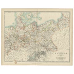
Antique Map of the German Empire by Johnston, '1909'
Located in Langweer, NL
Antique map titled 'Empire of Germany'. Original antique map of the German Empire. With inset maps of Berlin and Potsdam. This map originates from the ‘R...
Category
Early 20th Century Maps
Materials
Paper
$236 Sale Price
20% Off
You May Also Like
Large Original Antique Map of Europe by Sidney Hall, 1847
Located in St Annes, Lancashire
Great map of Europe
Drawn and engraved by Sidney Hall
Steel engraving
Original colour outline
Published by A & C Black. 1847
Unframed
Free shipping.
Category
Antique 1840s Scottish Maps
Materials
Paper

Map of Europe
Located in Los Angeles, CA
28 cities capitol drawings around the border of this Europe political map.
Category
Vintage 1950s Italian Mid-Century Modern Prints
$500
Large 19th Century Map of France
Located in Pease pottage, West Sussex
Large 19th Century Map of France.
Remarkable condition, with a pleasing age worn patina.
Recently framed.
France Circa 1874.
Category
Antique Late 19th Century French Maps
Materials
Linen, Paper

1790 Thomas Stackhouse Map, Entitled "Russia in Europe, " , Ric.a004
Located in Norton, MA
1790 Thomas Stackhouse map, entitled
"Russia in Europe"
Ric.a004
Stackhouse, Thomas
Russia in Europe [map]
London: T. Stackhouse, 1783. Map. Matted hand-colored copper engraving. Image size: 14.5 x 15.25 inches. Mat size: 22.75 x 23.75 inches. A beautiful example of this map of Eastern Europe...
Category
Antique 17th Century Unknown Maps
Materials
Paper

Original 1891 Walker Map
Located in Norwell, MA
Original 1891 map of Massachusetts by Walker. Towns include Cambridge, Boston, Dedham, Ashland, Brookline, Newton etc... burl wood frame. Measures...
Category
Antique 19th Century Maps

Original Antique Map of Europe, Arrowsmith, 1820
Located in St Annes, Lancashire
Great map of Europe
Drawn under the direction of Arrowsmith.
Copper-plate engraving.
Published by Longman, Hurst, Rees, Orme and Brown, 1820
...
Category
Antique 1820s English Maps
Materials
Paper

More Ways To Browse
The Vintage Map
Irish Antiques 16th Century
Mariners Chart
Papua New Guinea Antique Map
Bermuda Map
Scan Globe
Tunisia Antique Map
Antique Map New Orleans
Antique Maps Of Maryland
Gambia Antique Map
Antique Manitoba
Antique Map Of Brooklyn
Antique Map Of Michigan
Cham Antiques
Map Of Native American Tribes
Antique Furniture Halifax Furniture
Antique Furniture Trinidad
Antique Kiel Furniture