Items Similar to Grand Map of Europe by Frederick de Wit, Circa 1690: A Baroque Era Masterpiece.


Want more images or videos?
Request additional images or videos from the seller
1 of 10
Grand Map of Europe by Frederick de Wit, Circa 1690: A Baroque Era Masterpiece.
$1,150.22
£856.10
€960
CA$1,575.51
A$1,752.31
CHF 915
MX$21,323.77
NOK 11,685.98
SEK 10,959.39
DKK 7,308.14
Shipping
Retrieving quote...The 1stDibs Promise:
Authenticity Guarantee,
Money-Back Guarantee,
24-Hour Cancellation
About the Item
This is an attractive historical map of Europe created by Frederick de Wit, published around 1690. Here's a detailed description of the map and additional context about its creation:
Description of the Map:
- Geographical Coverage: The map displays all of Europe, stretching from the Atlantic Ocean in the west to the Ural Mountains in the east. It includes parts of North Africa and the Middle East as well.
- Details and Features: The map is highly detailed, showing numerous cities, towns, and geographical features such as rivers, mountains, and forests. The level of detail indicates a significant amount of cartographic knowledge for the time.
- Decorative Elements: The map features a decorative cartouche in the top left corner. This cartouche includes the figure of "Europa" sitting on a bull, referencing the mythological story of Europa and the bull. This adds an artistic and mythological element to the map.
- Sea Monsters and Ships: The map also includes various sea monsters and ships in the surrounding waters, a common decorative element in maps of this era, adding to its visual appeal and historical interest.
- Borders and Countries: The borders of countries and regions are delineated, reflecting the political boundaries of the late 17th century.
About the Maker:
- **Frederick de Wit:** Frederick de Wit was a prominent Dutch cartographer and engraver in the 17th century. Born in 1630 and passing away in 1706, de Wit was known for his high-quality maps and atlases.
- **Cartographic Contribution:** De Wit's work was highly regarded for its accuracy and artistic quality. His maps were detailed and often included decorative elements that made them both practical for navigation and attractive for display.
- **Atlas:** This particular map of Europe by Frederick de Wit is from his atlas titled "Atlas Maior." This atlas was one of de Wit's most significant works, containing a collection of detailed maps covering various parts of the world.
- **Publication Date:** The map was published around 1690, during the late Baroque period, a time when Dutch cartography was at its peak in terms of both scientific accuracy and artistic embellishment.
Summary:
This map of Europe by Frederick de Wit from around 1690 is a highly detailed and decorative piece of cartography. It features artistic elements such as a mythological cartouche and sea monsters, reflecting the cartographic and artistic trends of the late 17th century. As part of de Wit's "Atlas Maior," it exemplifies the blend of scientific knowledge and artistic craftsmanship characteristic of Dutch cartography during this period.
- Dimensions:Height: 20.67 in (52.5 cm)Width: 25.2 in (64 cm)Depth: 0.02 in (0.5 mm)
- Materials and Techniques:Paper,Engraved
- Place of Origin:
- Period:Late 17th Century
- Date of Manufacture:circa 1690
- Condition:Minor fading. Please study image carefully. Minor imperfections and some light toning due to handling and age. Folding line the middle as issued.
- Seller Location:Langweer, NL
- Reference Number:Seller: BG-091801stDibs: LU305439942251
About the Seller
5.0
Recognized Seller
These prestigious sellers are industry leaders and represent the highest echelon for item quality and design.
Platinum Seller
Premium sellers with a 4.7+ rating and 24-hour response times
Established in 2009
1stDibs seller since 2017
2,502 sales on 1stDibs
Typical response time: <1 hour
- ShippingRetrieving quote...Shipping from: Langweer, Netherlands
- Return Policy
Authenticity Guarantee
In the unlikely event there’s an issue with an item’s authenticity, contact us within 1 year for a full refund. DetailsMoney-Back Guarantee
If your item is not as described, is damaged in transit, or does not arrive, contact us within 7 days for a full refund. Details24-Hour Cancellation
You have a 24-hour grace period in which to reconsider your purchase, with no questions asked.Vetted Professional Sellers
Our world-class sellers must adhere to strict standards for service and quality, maintaining the integrity of our listings.Price-Match Guarantee
If you find that a seller listed the same item for a lower price elsewhere, we’ll match it.Trusted Global Delivery
Our best-in-class carrier network provides specialized shipping options worldwide, including custom delivery.More From This Seller
View AllAntique Map of Europe by Keizer & de Lat, 1788
Located in Langweer, NL
Antique map titled 'Kaartje van Europa (..)'. Uncommon original antique map of Europe. This map originates from 'Nieuwe Natuur- Geschied- en Handelkundige Zak- en Reisatlas' by Gerri...
Category
Antique Late 18th Century Maps
Materials
Paper

$383 Sale Price
20% Off
Antique Map of Europe Stretching from Northern Africa to the Baltic Sea, 1719
Located in Langweer, NL
Antique map titled 'Carte de la Germanie et les diferents Etats ou ses Peuples ont porté leurs conquestes'. Original antique map of Europe stretching from northern Africa to the Balt...
Category
Antique 18th Century Maps
Materials
Paper

$460 Sale Price
20% Off
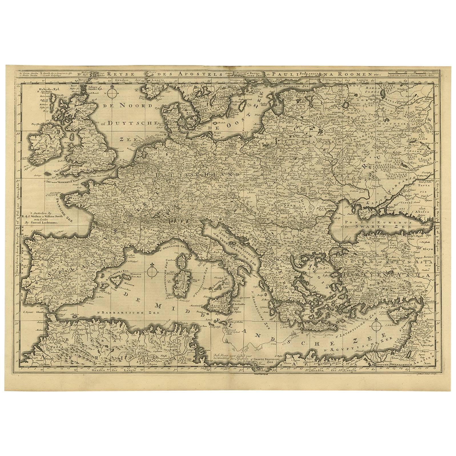
Rare Antique Bible Map of Southern Europe by A. Schut, 1743
Located in Langweer, NL
Antique map of the Mediterranean and a large part of Europe, illustrating the voyage of St. Paul to Rome. This map originates from ‘Biblia Sacra, dat is, de H. Schriftuer van het Oud...
Category
Antique Mid-18th Century Maps
Materials
Paper
$519 Sale Price
33% Off
Antique Map of Europe by R. Bonne, 1780
Located in Langweer, NL
A fine example of Rigobert Bonne and Guilleme Raynal’s 1780 map of Europe. Drawn by R. Bonne for G. Raynal’s Atlas de Toutes les Parties Connues du Globe Terrestre, Dressé pour l'His...
Category
Antique Late 18th Century French Maps
Materials
Paper

$150 Sale Price
30% Off
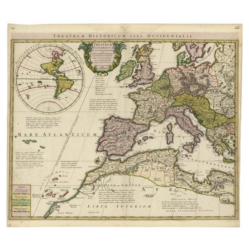
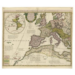
Finely Engraved Antique Map of Europe with inset of America, c.1745
By Guillaume De L'Isle
Located in Langweer, NL
Antique map titled 'Theatrum Historicum pars Occidentalis.' Finely engraved historical map with a profusion of details. It shows western Europe and the northern Mediterranean basin a...
Category
Antique 18th Century Maps
Materials
Paper
$1,389 Sale Price
20% Off
Antique Map of Europe by Hederichs, circa 1740
Located in Langweer, NL
Antique map titled 'Europa Christiani Orbis Domina'. Rare miniature map of Europe. This map originates from 'Anleitung Zu den fürnehmsten Historischen Wissenschaften, Benanntlich Der...
Category
Antique Mid-18th Century Maps
Materials
Paper

$239 Sale Price
20% Off
You May Also Like
Original Antique Map of Europe, Arrowsmith, 1820
Located in St Annes, Lancashire
Great map of Europe
Drawn under the direction of Arrowsmith.
Copper-plate engraving.
Published by Longman, Hurst, Rees, Orme and Brown, 1820
...
Category
Antique 1820s English Maps
Materials
Paper

17th Century Nicolas Visscher Map of Southeastern Europe
Located in Hamilton, Ontario
A beautiful, highly detailed map of southeastern Europe by Nicolas Visscher. Includes regions of Northern Italy (showing the cities Bologna, Padua, and Venice), Bohemia, Austria (sho...
Category
Antique 17th Century Dutch Maps
Materials
Paper

$1,350 Sale Price
38% Off
Europe: An Original 18th Century Hand-colored Map by E. Bowen
Located in Alamo, CA
This is an original 18th century hand-colored map entitled "A New & Accurate Map of Europe Drawn from the Best Authorities Assisted by the Most Improved Modern Charts and Maps." by E...
Category
Mid-18th Century Old Masters Landscape Prints
Materials
Engraving

1718 Ides & Witsen Map "Route D'amsterdam a Moscow Et De La Ispahan Et Gamron
Located in Norton, MA
1718 Ides & Witsen map, entitled
"Route D'Amsterdam A Moscow Et De La Ispahan Et Gamron,"
Ric.b005
Subject: Eastern Europe and Central Asia
Period: 1718 (published)
Publicati...
Category
Antique Early 18th Century Dutch Maps
Materials
Paper

1714 Henri Chatelain "Nouvelle Carte Des Etatas Du Grand.Duc De Mos Moscovie Eur
Located in Norton, MA
A 1714 Henri Chatelain map, entitled
"Nouvelle Carte Des Etatas Du Grand Duc De Moscovie En Europe,"
Ricb001
Henri Abraham Chatelain (1684-1743) was a Huguenot pastor of Parisi...
Category
Antique Early 18th Century Dutch Maps
Materials
Paper

Southern & Eastern Europe: A Large 17th C. Hand-colored Map by Sanson & Jaillot
By Nicolas Sanson
Located in Alamo, CA
This large hand-colored map entitled "Estats de L'Empire des Turqs en Europe, ou sont les Beglerbeglicz our Gouvernements" was originally created by Nicholas Sanson d'Abbeville and t...
Category
Antique 1690s French Maps
Materials
Paper

More Ways To Browse
Baroque Cartouche
Sea Monster
Carved Cabriole Table
Dark Antique Table
Antique Wall Table
1960 Chair Wood Danish
Unusual Dining Table
Antique Dutch Plates
Mdf Table
Showcase Coffee Table
Space Age Orange
Vallauris France
Silver Ladle
Scalloped Table
Brazil Wood Chairs
Vintage Art Deco Side Tables
Window Display
1960s Cushion Chair