Items Similar to Highly Detailed Antique Map of Brabant, Province of the Netherlands, ca.1700


Want more images or videos?
Request additional images or videos from the seller
1 of 5
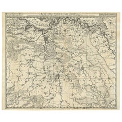
Highly Detailed Antique Map of Brabant, Province of the Netherlands, ca.1700
$1,102.29
$1,377.8720% Off
£820.43
£1,025.5420% Off
€920
€1,15020% Off
CA$1,509.86
CA$1,887.3320% Off
A$1,679.30
A$2,099.1220% Off
CHF 876.88
CHF 1,096.1020% Off
MX$20,435.28
MX$25,544.1020% Off
NOK 11,199.07
NOK 13,998.8320% Off
SEK 10,502.75
SEK 13,128.4420% Off
DKK 7,003.64
DKK 8,754.5520% Off
Shipping
Retrieving quote...The 1stDibs Promise:
Authenticity Guarantee,
Money-Back Guarantee,
24-Hour Cancellation
About the Item
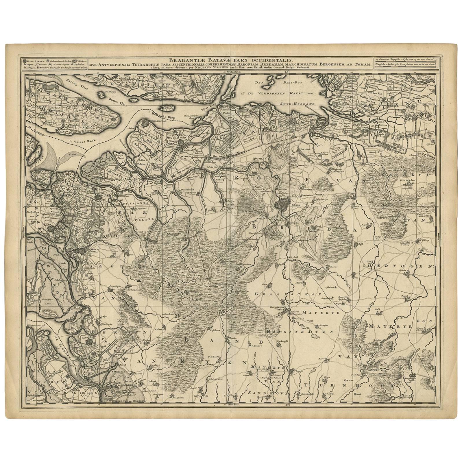
Antique print, titled: 'Brabantiae Batavae Pars Occidentalis : sive Antuerpiensis Tetrarchiae Pars Septentrionalis comprehendens Baroniam Bredanam, Marchionatum Bergensem ad Zoman aliasque minores ditiones.'
Highly detailed map of the region between Bergen Op Zoom, Breda, Hoogstraten and Sandvliet, The Netherlands. Published by Pieter Schenk c. 1700.
Artists and Engravers: Made by 'Nicolaes Visscher' after 'Pieter Schenk'. Made by an anonymous engraver after 'N. ten Have'. The Visscher family were art and map dealers in Amsterdam during the 17th century. Funded by C. J. Visscher (1587-1652), the business was continued by his son and grandson both named Nicolas. Nicolas Visscher I was born 1618 in Wenns, Austria. He died 1679 in Linz. After the death of Nicolas II, his widow passed the business to Pieter Schenk. Pieter Schenk / Petrus Schenck ( 1660-1718/19) was born in Germany, but settled in Amsterdam where he first became a pupil of Gerard Valck, the engraver. In 1687 he married Valck's sister and thereafter the Schenk and Valck families were active over a long period with a wide range of interests as print sellers, publishers of books, maps, topographical and architectural drawings and globes. Although they produced some original maps, most of their atlases consisted of printings from revised and re-worked plates originally by Jansson, the Visschers, the Sansons and others. Peter Schenk the Younger (1693-1775) was a Dutch engraver and map publisher active in Amsterdam and Leipzig.
Condition: Good, given age. Minor paper separation lower middle fold; repaired. Horizontal crease left to right. A soft crease in the left edge of the sheet. Brown stain right to lower middle fold. A few spots in the margins. Original middle fold as issued. General age-related toning and/or occasional minor defects from handling. Please study scan carefully.
- Dimensions:Height: 20.95 in (53.2 cm)Width: 24.41 in (62 cm)Depth: 0 in (0.02 mm)
- Materials and Techniques:
- Period:1700-1709
- Date of Manufacture:circa 1700
- Condition:Repaired: Minor paper separation lower middle fold; repaired. Horizontal crease left to right. A soft crease in the left edge of the sheet. Wear consistent with age and use. Brown stain right to lower middle fold. A few spots in the margins. Original middle fold as issued.
- Seller Location:Langweer, NL
- Reference Number:Seller: PCT-580191stDibs: LU3054326822162
About the Seller
5.0
Recognized Seller
These prestigious sellers are industry leaders and represent the highest echelon for item quality and design.
Platinum Seller
Premium sellers with a 4.7+ rating and 24-hour response times
Established in 2009
1stDibs seller since 2017
2,508 sales on 1stDibs
Typical response time: <1 hour
- ShippingRetrieving quote...Shipping from: Langweer, Netherlands
- Return Policy
Authenticity Guarantee
In the unlikely event there’s an issue with an item’s authenticity, contact us within 1 year for a full refund. DetailsMoney-Back Guarantee
If your item is not as described, is damaged in transit, or does not arrive, contact us within 7 days for a full refund. Details24-Hour Cancellation
You have a 24-hour grace period in which to reconsider your purchase, with no questions asked.Vetted Professional Sellers
Our world-class sellers must adhere to strict standards for service and quality, maintaining the integrity of our listings.Price-Match Guarantee
If you find that a seller listed the same item for a lower price elsewhere, we’ll match it.Trusted Global Delivery
Our best-in-class carrier network provides specialized shipping options worldwide, including custom delivery.More From This Seller
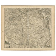
View AllAntique Map of Brabant 'The Netherlands' by N. Visscher, circa 1690
Located in Langweer, NL
Antique map titled 'Brabantiae Batavae Pars Occidentalis (..)'. Highly detailed map of the region between Bergen Op Zoom, Breda, Hoogstraten and Sandvliet, The Netherlands. Published...
Category
Antique Late 17th Century Maps
Materials
Paper
$632 Sale Price
20% Off
Antique Map of the Province Groningen in The Netherlands, c.1680
Located in Langweer, NL
Antique map titled 'Groningae et Omlandiae Dominium vulgo de Provincie van Stadt en Lande'.
Old map of the province of Groningen, the Netherlands. This map originates from 'Germani...
Category
Antique 17th Century Maps
Materials
Paper

$469 Sale Price
20% Off
Antique Map of Brabant 'The Netherlands' by N. Visscher, circa 1690
Located in Langweer, NL
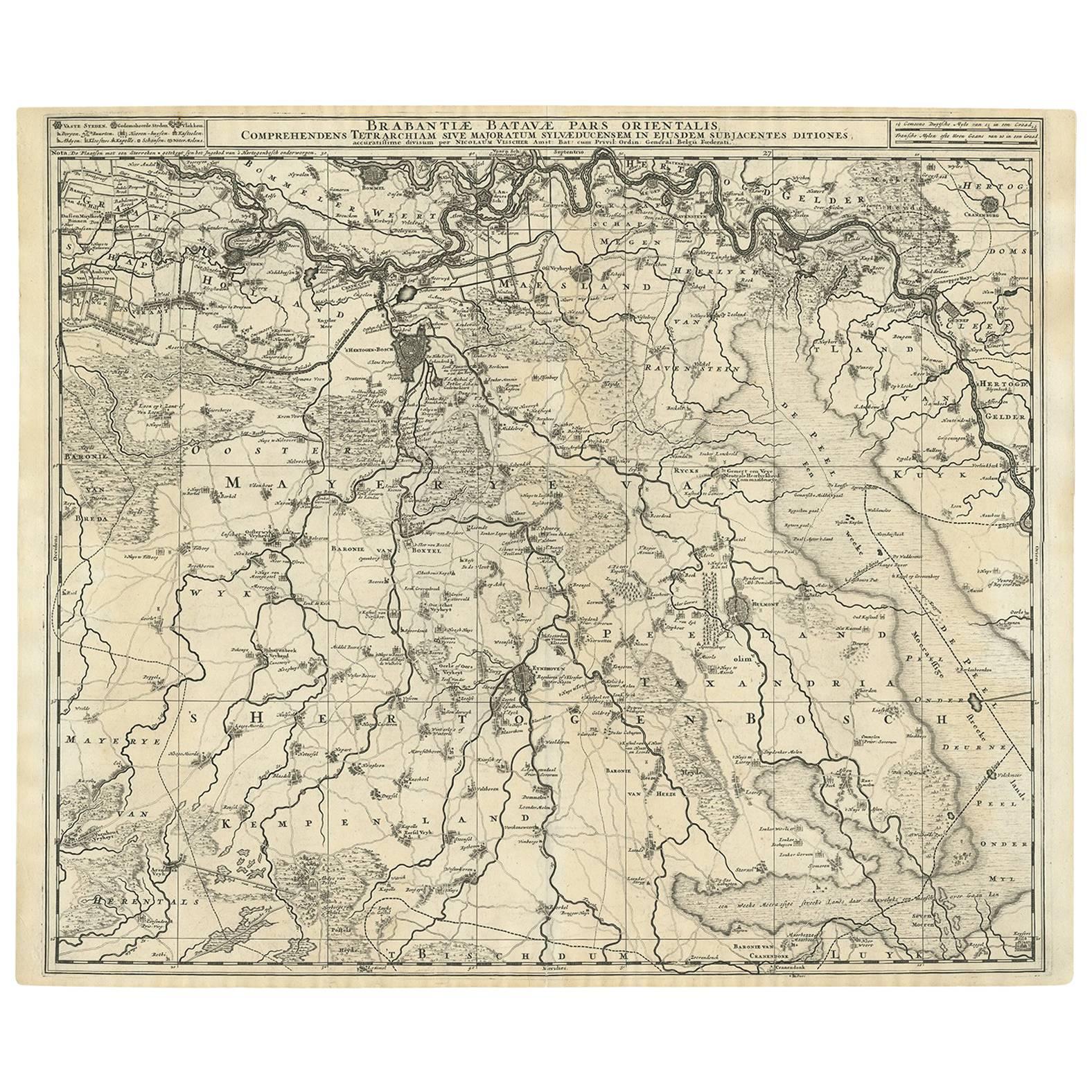
Antique map titled 'Brabantiae Batavae pars orientalis, comprehendens Tetrarchiam sive majoratum sylvaeducensem in ejusdem subjacentes ditiones (..)'. Map of the Dutch province 'Brab...
Category
Antique Mid-18th Century Maps
Materials
Paper
$575 Sale Price
20% Off
Antique Map of Friesland by De Wit, c.1690
Located in Langweer, NL
Antique map titled 'Tabula Comitatus Frisiae'.
Old map of the province of Friesland, the Netherlands. With a small inset map of the Wadden area. Third state of the map by Schotan...
Category
Antique 17th Century Maps
Materials
Paper

$785 Sale Price
20% Off
Antique Map of the Province of Gelderland, the Netherlands, c.1690
Located in Langweer, NL
Antique map titled 'Ducatus Geldriae novissima descriptio'. Map of Gelderland, The Netherlands. Shows many cities (like Arnhem, Nijmegen, Eindhoven, Zutphen, Zwolle, etc), roads, riv...
Category
Antique 17th Century Maps
Materials
Paper

$478 Sale Price
20% Off
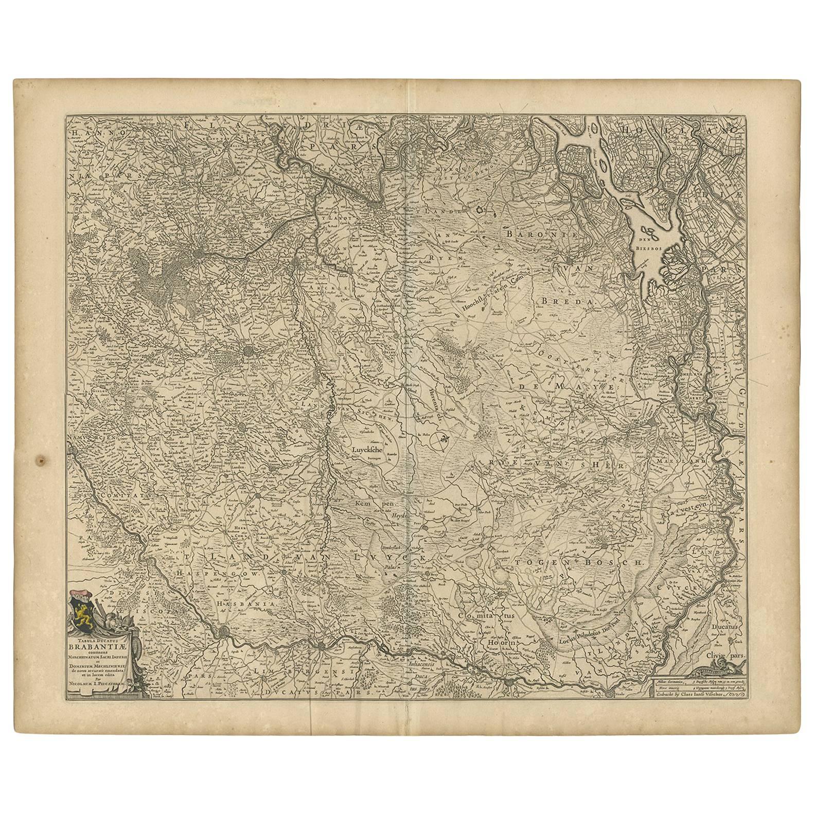
Antique Map of Brabant 'The Netherlands' by N. Visscher, circa 1670
Located in Langweer, NL
Detailed map of the southern part of The Netherlands and the northern part of Belgium with Antwerp and Brussels. In the corner top left in Holland with Rotterdam partly on the map. S...
Category
Antique Mid-17th Century Maps
Materials
Paper
$594 Sale Price
20% Off
You May Also Like
1752 Vaugoundy Map of Flanders : Belgium, France, and the Netherlands, Ric.a002
Located in Norton, MA
Large Vaugoundy Map of Flanders:
Belgium, France, and the Netherlands
Colored -1752
Ric.a002
Description: This is a 1752 Didier Robert de Vaugondy map of Flanders. The map de...
Category
Antique 17th Century Unknown Maps
Materials
Paper

1635 Willem Blaeu Map of Northern France"Comitatvs Bellovacvm" Ric.a08
Located in Norton, MA
1635 Willem Blaeu map of northern France, entitled.
"Comitatvs Bellovacvm Vernacule Beavvais,"
Colored
Ric.a008
“COMITATVS BELLOVACVM…” Amsterdam: W...
Category
Antique 17th Century Unknown Maps
Materials
Paper

17th Century Hand Colored Map of the Liege Region in Belgium by Visscher
By Nicolaes Visscher II
Located in Alamo, CA
An original 17th century map entitled "Leodiensis Episcopatus in omnes Subjacentes Provincias distincté divisusVisscher, Leodiensis Episcopatus" by Nicolaes Visscher II, published in Amsterdam in 1688. The map is centered on Liege, Belgium, includes the area between Antwerp, Turnhout, Roermond, Cologne, Trier and Dinant.
This attractive map is presented in a cream-colored mat measuring 30" wide x 27.5" high. There is a central fold, as issued. There is minimal spotting in the upper margin and a tiny spot in the right lower margin, which are under the mat. The map is otherwise in excellent condition.
The Visscher family were one of the great cartographic families of the 17th century. Begun by Claes Jansz Visscher...
Category
Antique Late 17th Century Dutch Maps
Materials
Paper

1643 Willem&Joan Blaeu Map NW Flanders "Flandriae Teutonicae Pars Prientalior
Located in Norton, MA
1643 Willem and Joan Blaeu map of northwest Flanders, entitled
"Flandriae Teutonicae Pars Prientalior,"
Ric0012
" Authentic" - Map of the northwest Fl...
Category
Antique 17th Century Dutch Maps
Materials
Paper

1657 Janssonius Map of Vermandois and Cappelle, Ric. A-004
Located in Norton, MA
1657 Janssonius map of
Vermandois and Cappelle
Ric.a004
Description: Antique map of France titled 'Descriptio Veromanduorum - Gouvernement de la Cappelle'. Two detailed maps o...
Category
Antique 17th Century Unknown Maps
Materials
Paper

1640 Joan Bleau Map Entitled"Diocecese de rheims et le pais de rethel, " Eic.a011
Located in Norton, MA
1640 Joan Bleau map entitled
"Diocecese de rheims et le pais de rethel,"
Ric.a011
OAN BLAEU
Diocecese de Rheims, et le pais de Rethel.
Handcolored engraving, c.1640.
...
Category
Antique 17th Century Dutch Maps
Materials
Paper

More Ways To Browse
Netherlands Sellers
Antique Books Amsterdam
17th Century Dutch Drawings
Scan Globe
World Map Of Trade Routes
Albanian Antique
Antique Furniture Wiltshire
Antique Maps Of Israel
Framed Africa Maps
Antique Furniture Goa
Croatian Antiques
Map Of Israel
Teak Sphere
18th Century Scottish Collectibles
Map Of Mexican California
Ottoman Map
Antique Map Of Korea
Maps South East Asia