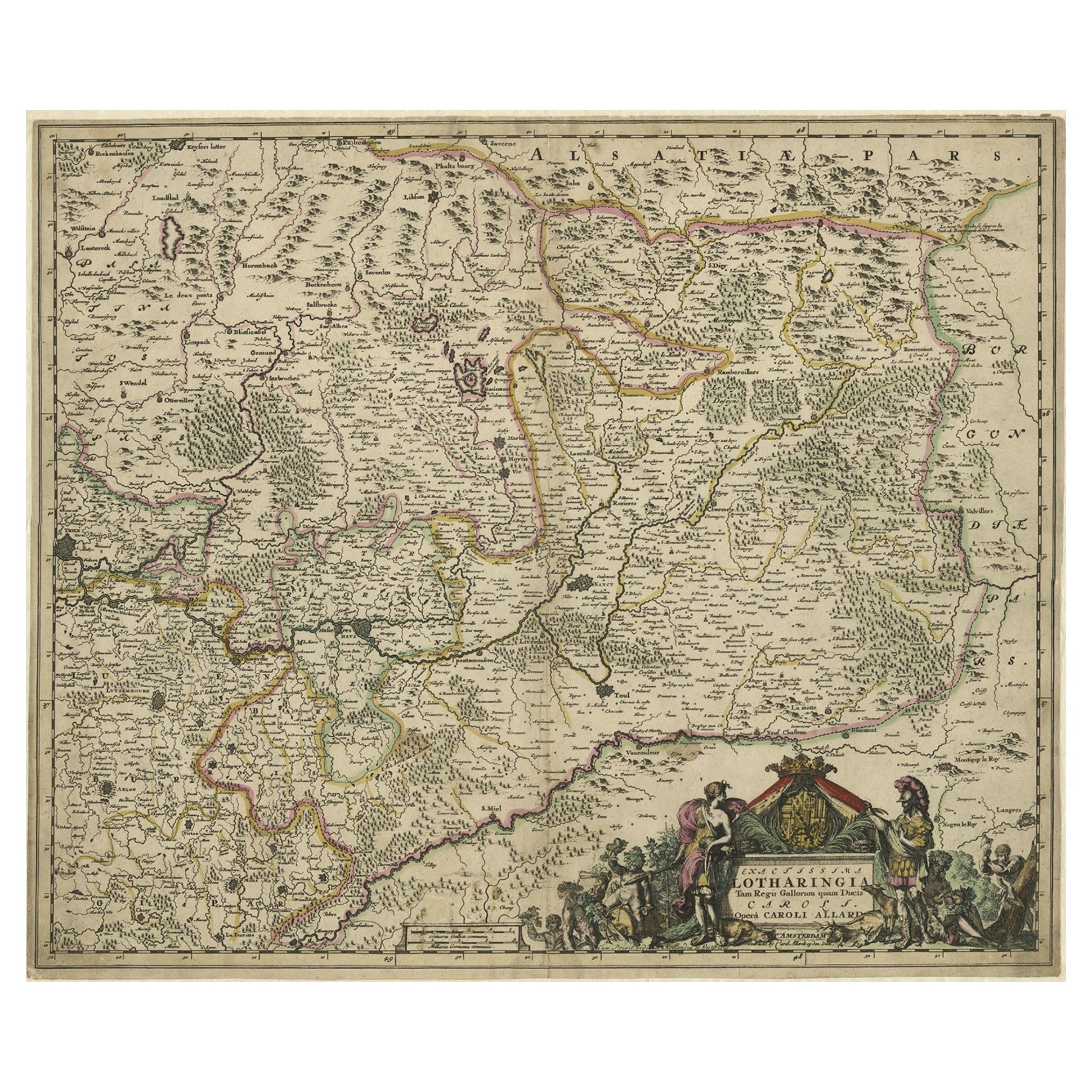
Items Similar to Historic 1690 Map of Lorraine in France by Allard - Cities of Toul, Nancy, Metz


Want more images or videos?
Request additional images or videos from the seller
1 of 10
Historic 1690 Map of Lorraine in France by Allard - Cities of Toul, Nancy, Metz
$650.98
$813.7220% Off
£487.27
£609.0920% Off
€552
€69020% Off
CA$895.93
CA$1,119.9120% Off
A$998.61
A$1,248.2620% Off
CHF 523.94
CHF 654.9220% Off
MX$12,194.64
MX$15,243.3020% Off
NOK 6,634.17
NOK 8,292.7120% Off
SEK 6,270.30
SEK 7,837.8720% Off
DKK 4,202.21
DKK 5,252.7720% Off
About the Item
Exactissima Lotharingia - A Rare 17th Century Map of Lorraine by Carel Allard
This fascinating map of Lorraine, created by Carel Allard around 1690, is a stunning example of copperplate engraving and old coloring. Carel Allard, a renowned Dutch cartographer and engraver from Amsterdam, was highly respected for his meticulous and detailed maps. This map, titled Exactissima Lotharingia Tam Regis Gallorum quam Ducis Caroli Opera Caroli Allard, is an exquisite representation of the historical region of Lorraine, located in northern France.
The map is oriented with the west at the top, offering a unique perspective on the area, which includes the cities of Toul, Nancy, Metz, and Trier. The map’s vibrant hand coloring, typical of the period, enhances the geographic and political divisions, while highlighting significant cities and regions in rich red tones. The borders of Lorraine are prominently marked, and the topography of the region is meticulously illustrated with fine lines depicting rivers, hills, and forests.
Carel Allard's engraving technique is a testament to the masterful craftsmanship of the late 17th century. Copperplate engraving was a labor-intensive process where the cartographer would meticulously incise the design into a copper plate, which was then inked and pressed onto paper. The old hand coloring adds depth and aesthetic appeal, making each map unique. The decorative cartouche in the lower right corner of the map is a masterpiece in itself. It features allegorical figures, soldiers, and a coat of arms, symbolizing the pride and heritage of Lorraine. The presence of these decorative elements not only enhances the visual appeal but also provides insight into the cultural and political significance of the region during that period.
What makes this map particularly interesting is its historical context and rarity. Allard’s maps were not produced in large quantities, and their survival through centuries makes them highly collectible. The geographical accuracy and artistic flair make it a valuable piece for both map collectors and historians. Lorraine, as depicted on the map, was an area of great strategic and political importance during the late 17th century, situated between France and the Holy Roman Empire. The detailed depiction of cities, rivers, and natural landscapes showcases Allard’s dedication to precision and his artistic touch in portraying the region's rich heritage.
Condition: The map has been framed before but is preserved in good condition. It has an overall even toning, which is typical for maps of this age. A small hole is in the right border, hardly noticeable. The colors are vivid, retaining their original vibrancy.
Framing Tips: For framing, it is recommended to use acid-free materials and UV-protected glass to preserve the old coloring and prevent fading. A classic wooden frame with a neutral or gold tone will complement the historical essence of the piece and highlight its decorative cartouche.
- Dimensions:Height: 19.69 in (50 cm)Width: 24.02 in (61 cm)Depth: 0.01 in (0.2 mm)
- Materials and Techniques:Paper,Engraved
- Period:1690-1699
- Date of Manufacture:circa 1690
- Condition:The map has been framed before but is preserved in good condition. It has an overall even toning, which is typical for maps of this age. A small hole is in the right border, hardly noticeable. The colors are vivid, retaining their original vibrancy.
- Seller Location:Langweer, NL
- Reference Number:Seller: BG-13659-31stDibs: LU3054344168902
About the Seller
5.0
Recognized Seller
These prestigious sellers are industry leaders and represent the highest echelon for item quality and design.
Platinum Seller
Premium sellers with a 4.7+ rating and 24-hour response times
Established in 2009
1stDibs seller since 2017
2,513 sales on 1stDibs
Typical response time: <1 hour
- ShippingRetrieving quote...Shipping from: Langweer, Netherlands
- Return Policy
Authenticity Guarantee
In the unlikely event there’s an issue with an item’s authenticity, contact us within 1 year for a full refund. DetailsMoney-Back Guarantee
If your item is not as described, is damaged in transit, or does not arrive, contact us within 7 days for a full refund. Details24-Hour Cancellation
You have a 24-hour grace period in which to reconsider your purchase, with no questions asked.Vetted Professional Sellers
Our world-class sellers must adhere to strict standards for service and quality, maintaining the integrity of our listings.Price-Match Guarantee
If you find that a seller listed the same item for a lower price elsewhere, we’ll match it.Trusted Global Delivery
Our best-in-class carrier network provides specialized shipping options worldwide, including custom delivery.More From This Seller
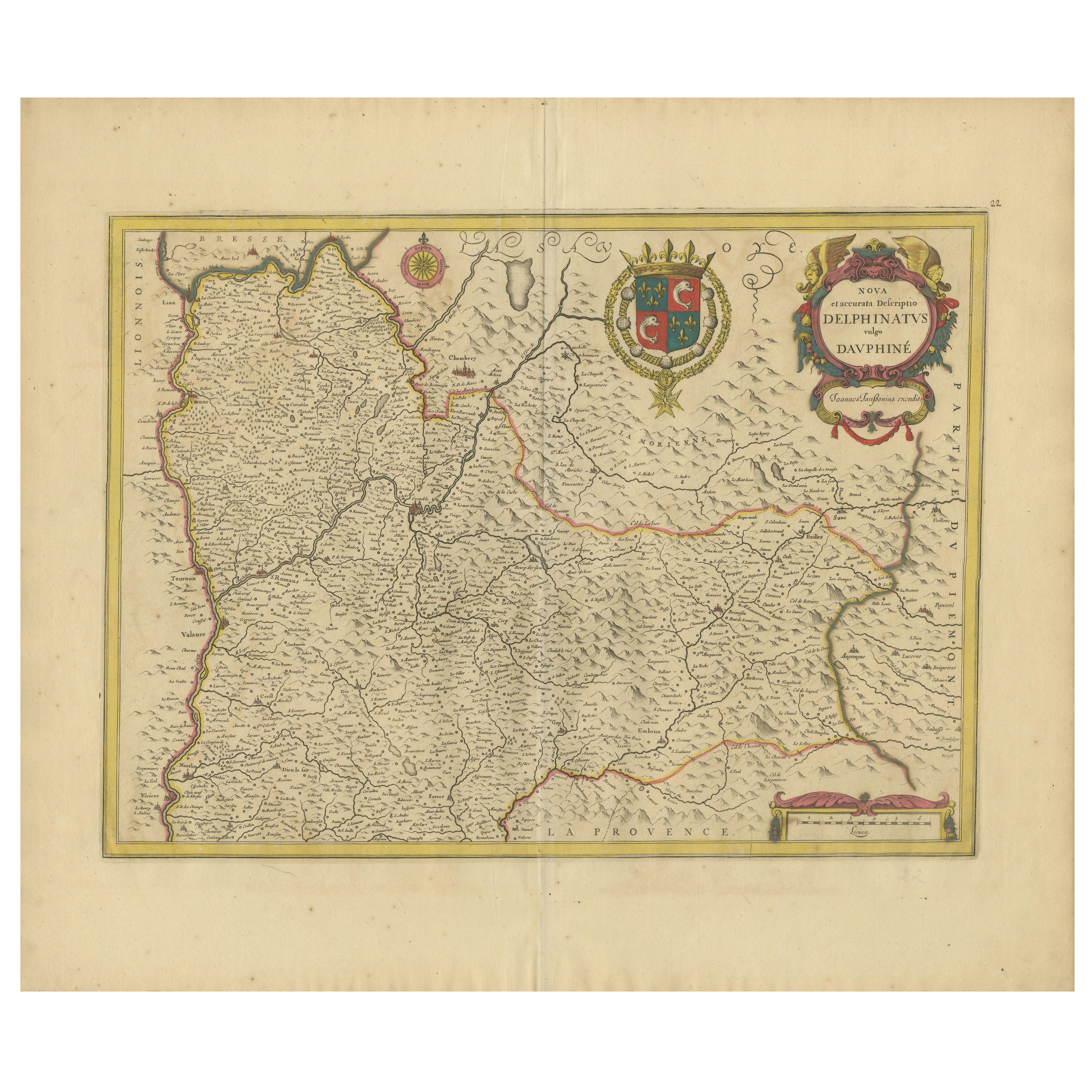
View AllRare 17th-Century Map of Dauphiné in Southeastern France by F. De Wit, ca.1688
Located in Langweer, NL
Title: Rare Hand-Colored 17th-Century Map of Dauphiné by Frederik De Wit c. 1688
Description: This captivating 17th-century map of Dauphiné, titled "Nova et Accurata Delphinatus Vul...
Category
Antique 1680s Maps
Materials
Paper

Antique Map of the Region of Touraine by Janssonius 'circa 1650'
By Johannes Janssonius
Located in Langweer, NL
Antique map of France titled 'Touraine - Turonensis Ducatus'. Decorative map of the Touraine region, France. It shows the cities of Tours, Amboise and others. Published by J. Jansson...
Category
Antique Mid-17th Century Maps
Materials
Paper

$424 Sale Price
20% Off
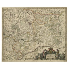
Striking Antique Map of Luxembourg and Northern France 'Lotharingen', c.1680
Located in Langweer, NL
Description: Antique map titled 'Exactissima Lotharingia tam Regis Gallorum quam Ducis.' -
Striking map of Luxembourg and Northern France. Includ...
Category
Antique 1680s Maps
Materials
Paper
$613 Sale Price
20% Off
Antique Map of the Artois Region 'France' by F. de Wit, circa 1680
Located in Langweer, NL
Antique map titled 'Tabula Comitatus Artesiae emendata'. Large map of the Artois region, France. Published by F. de Wit, circa 1680.
Category
Antique Late 17th Century Maps
Materials
Paper

$508 Sale Price
25% Off
Antique Map of the Region of Lyon by Hondius, circa 1630
Located in Langweer, NL
Antique map titled 'Lionnois, Forest et Beauiolois'. Old map of the former region of Lyon, Vienne, Bresse, Rohan and the Rhône River. This map originates f...
Category
Antique Mid-17th Century Maps
Materials
Paper

$471 Sale Price
20% Off
Antique Map of the Limoges Region in France, c.1690
Located in Langweer, NL
Antique map titled 'Le Diocèse de Limoges'. Large map of the Limoges region, France.
The map is dedicated to the bishop of Limoges, Antoine de Charpin.
Artists and Engravers:...
Category
Antique 17th Century Maps
Materials
Paper

$613 Sale Price
20% Off
You May Also Like
1640 Joan Bleau Map Entitled"Diocecese de rheims et le pais de rethel, " Eic.a011
Located in Norton, MA
1640 Joan Bleau map entitled
"Diocecese de rheims et le pais de rethel,"
Ric.a011
OAN BLAEU
Diocecese de Rheims, et le pais de Rethel.
Handcolored engraving, c.1640.
...
Category
Antique 17th Century Dutch Maps
Materials
Paper

1656 Jansson Map Metz Region of France Entitled "Territorium Metense" Ric0014
Located in Norton, MA
1656 Jansson map Metz Region of France entitled "Territorium Metense."
Ric0014
" Authentic" - Map of the historical region surrounding Metz, in Lorraine, France.
Oriented with ...
Category
Antique 17th Century Dutch Maps
Materials
Paper

17th Century Hand-Colored Map of a Region in West Germany by Janssonius
By Johannes Janssonius
Located in Alamo, CA
This attractive highly detailed 17th century original hand-colored map is entitled "Archiepiscopatus Maghdeburgensis et Anhaltinus Ducatus cum terris adjacentibus". It was published ...
Category
Antique Mid-17th Century Dutch Maps
Materials
Paper

1635 Willem Blaeu Map of Northern France"Comitatvs Bellovacvm" Ric.a08
Located in Norton, MA
1635 Willem Blaeu map of northern France, entitled.
"Comitatvs Bellovacvm Vernacule Beavvais,"
Colored
Ric.a008
“COMITATVS BELLOVACVM…” Amsterdam: W...
Category
Antique 17th Century Unknown Maps
Materials
Paper

1625 Mercator Map of the Provenience of Quercy, "Quercy Cadvrcivm Ric.0013
Located in Norton, MA
1625 Mercator map of the provenience of Quercy, entitled
"Quercy Cadvrcivm,"
Ric.0013
" Authentic" - Map of the provenience of Quercy Cadvrcivm
D...
Category
Antique 17th Century French Maps
Materials
Paper

1657 Janssonius Map of Vermandois and Cappelle, Ric. A-004
Located in Norton, MA
1657 Janssonius map of
Vermandois and Cappelle
Ric.a004
Description: Antique map of France titled 'Descriptio Veromanduorum - Gouvernement de la Cappelle'. Two detailed maps o...
Category
Antique 17th Century Unknown Maps
Materials
Paper

More Ways To Browse
Coat Of Arms Engraving
Antique Opera Glasses
Gold Opera Coat
Gold Opera Glasses
Wooden Soldiers
Opera Plates
Antique French Opera Glasses
Flair Holland
Antique Opera Glasses Opera Collectables
Vintage Scandanavian Chairs
19th Century Red Glass
Antique French Console Table Tables
Silver Bowl Large
Antique French Silk
Down Couch
Used Lighter Art
Blue Edge Glass
Mahogany 1950s Furniture