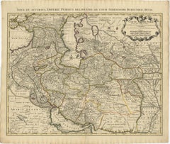
Items Similar to Imperii Persici Delineatio: A 1722 Cartographic Masterpiece of Persia by Schenk

Want more images or videos?
Request additional images or videos from the seller
1 of 6
Imperii Persici Delineatio: A 1722 Cartographic Masterpiece of Persia by Schenk
$1,101.60
$1,377.0120% Off
£814.33
£1,017.9120% Off
€920
€1,15020% Off
CA$1,498.26
CA$1,872.8220% Off
A$1,678.79
A$2,098.4920% Off
CHF 873.87
CHF 1,092.3420% Off
MX$20,537.42
MX$25,671.7820% Off
NOK 11,092.22
NOK 13,865.2820% Off
SEK 10,476.47
SEK 13,095.5920% Off
DKK 7,005.35
DKK 8,756.6920% Off
Shipping
Retrieving quote...The 1stDibs Promise:
Authenticity Guarantee,
Money-Back Guarantee,
24-Hour Cancellation
About the Item
Title: IMPERII PERCICI delineatio ex scriptis potissimum geographicis Arabum et Persarum
Cartographer: Petrus Schenk (Pieter Schenk), 1722
An original antique hand-colored engraved map that primarily covers the Persian Empire, extending into parts of the neighboring regions, including Armenia, Arabia, and parts of Central Asia.
The map features an ornate 'curtain' style cartouche in the upper right corner, adding an element of artistic decoration typical of the period.
The regions are hand-colored, often in pastel shades of pink, green, and yellow, distinguishing various territories and regions within the Persian Empire.
Mountains, rivers, and other topographical features are illustrated, giving a sense of the physical geography of the region.
Various cities and settlements are marked, some with small illustrations of buildings or symbols indicating their importance or size.
Regions Highlighted:
- Armenia: Located in the northwest, adjacent to the Black Sea.
- Arabia: The southern regions, labeled as part of the Arabian Peninsula.
- Mesopotamia: The fertile region between the Tigris and Euphrates rivers, indicating its historical significance.
- Caspian Sea: Prominently shown in the northern part of the map, with detailed coastline and surrounding regions.
The Maker: Petrus Schenk
Background:
- Petrus Schenk (1660-1711): A well-known Dutch cartographer, engraver, and publisher based in Amsterdam. He was renowned for his detailed and decorative maps, as well as for his work in producing globes.
- Reputation: Schenk was part of a family of mapmakers and had a significant influence on the cartographic and publishing world in the late 17th and early 18th centuries. His works are characterized by their artistic flourish and meticulous attention to detail.
What Makes This Map Interesting
1. **Historical Context:**
- **Early 18th Century Cartography:** The map represents the state of geographical knowledge in the early 18th century, a period when European interest in the Middle East and Central Asia was high due to trade routes and colonial ambitions.
- **Persian Empire:** It provides a detailed look at the Persian Empire, a historically significant empire known for its rich culture, strategic military presence, and contributions to art and science.
2. **Artistic Elements:**
- **Hand-Coloring:** The use of hand-coloring adds a unique artistic element, making each copy of the map slightly different and a piece of art in its own right.
- **Decorative Cartouches:** The ornate title cartouche is a typical feature of maps from this period, combining artistic expression with informational content.
3. **Cultural Significance:**
- **Cross-Cultural Documentation:** The map’s reliance on Arabic and Persian geographic sources illustrates the cross-cultural exchange of knowledge and the European effort to document and understand non-European territories.
- **Educational Value:** Maps like these were not only tools for navigation and understanding geography but also served as educational tools for Europeans to learn about distant lands.
4. **Rarity and Collectibility:**
- **Antique Value:** As a map from 1722, it holds significant antique value. Maps from this era are sought after by collectors and historians for their beauty and historical importance.
- **Petrus Schenk’s Signature Style:** Schenk’s maps are particularly valued for their artistic and detailed approach, making them prized items in collections of antique maps.
In summary, this map by Petrus Schenk is an intriguing blend of art, history, and geography, offering insights into the Persian Empire as understood by early 18th-century European cartographers. Its detailed depiction of regions, hand-coloring, and decorative elements make it a fascinating and valuable piece for both historical and artistic study.
- Dimensions:Height: 20.08 in (51 cm)Width: 23.43 in (59.5 cm)Depth: 0.01 in (0.2 mm)
- Materials and Techniques:Paper,Engraved
- Period:1720-1729
- Date of Manufacture:1722
- Condition:Repaired: Tear restored in right margin. Good, considering age. Fold as published. Remains of tape glue in margin on reverse. General age-related toning and/or occasional minor defects around the edges. Original Old Hand-Coloring. Please study scan carefully.
- Seller Location:Langweer, NL
- Reference Number:Seller: BG-13741-21stDibs: LU3054340347102
About the Seller
5.0
Recognized Seller
These prestigious sellers are industry leaders and represent the highest echelon for item quality and design.
Platinum Seller
Premium sellers with a 4.7+ rating and 24-hour response times
Established in 2009
1stDibs seller since 2017
2,493 sales on 1stDibs
Typical response time: <1 hour
- ShippingRetrieving quote...Shipping from: Langweer, Netherlands
- Return Policy
Authenticity Guarantee
In the unlikely event there’s an issue with an item’s authenticity, contact us within 1 year for a full refund. DetailsMoney-Back Guarantee
If your item is not as described, is damaged in transit, or does not arrive, contact us within 7 days for a full refund. Details24-Hour Cancellation
You have a 24-hour grace period in which to reconsider your purchase, with no questions asked.Vetted Professional Sellers
Our world-class sellers must adhere to strict standards for service and quality, maintaining the integrity of our listings.Price-Match Guarantee
If you find that a seller listed the same item for a lower price elsewhere, we’ll match it.Trusted Global Delivery
Our best-in-class carrier network provides specialized shipping options worldwide, including custom delivery.More From This Seller
View All1742 Antique Map of the Persian Empire with Detailed Borders and Cartouche
Located in Langweer, NL
Title: 1742 Covens & Mortier Map of the Persian Empire by Guillaume De L'Isle
This remarkable 1742 map, "Carte de Perse," was originally designed by Guillaume De L'Isle, a preemin...
Category
Antique 1740s Dutch Maps
Materials
Paper
Authentic Old Map of Persia with Original Border Coloring, 1745
Located in Langweer, NL
Title: "Kaartje van Persien na de stelling van den Heer Guillaume de L'Isle"
Translates to "Map of Persia based on the work of Mr. Guillaume de L'Isle." Guillaume de L'Isle was a p...
Category
Antique 1740s Maps
Materials
Paper

Rare Antique Map of Persia, Incl the Caspian Sea and the Arabian Peninsula, 1726
Located in Langweer, NL
Rare untitled antique map of Persia. It covers from the Gulf of Suez eastward to Ahmedabad (Amadabad) in modern day western India. This map, centered on Persia, includes the Caspian Sea and part of the Arabian Peninsula...
Category
Antique 1720s Maps
Materials
Paper
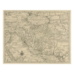
$814 Sale Price
20% Off
Antique Map of Eastern Turkey, Caucasus, Israel through Iraq and part of Arabia
Located in Langweer, NL
Antique map titled 'Nieuwe Kaart van Irak Arabia, Kurdistan, Diarbek, Turkomannia, Syrie en het Heilige Land'. Beautiful map including eastern Turkey, the Caucasus, Israel through Ir...
Category
Antique Mid-18th Century Maps
Materials
Paper

$440 Sale Price
20% Off
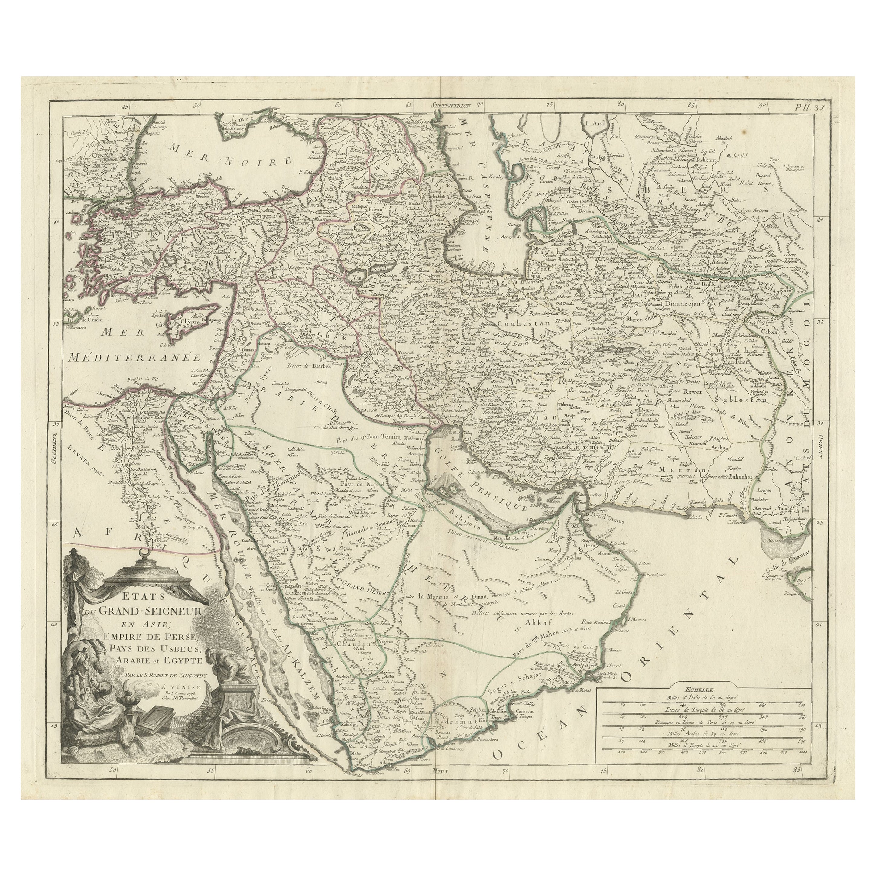
Detailed Original Antique Map of the Turkish Empire with Arabia, 1778
Located in Langweer, NL
Title: Etats Due Grand-Seigneur En Asie, Empire De Perse, Pays Des Usbecs, Arabie et Egypte . . . 1753
Detailed map of the Turkish Empire, extending to the Black Sea, Georgia, the...
Category
Antique 1770s Maps
Materials
Paper

$459 Sale Price
20% Off
Antique Map of Persia by A. Zatta, circa 1785
Located in Langweer, NL
Antique map titled 'L'Impero della Persia diviso ne suoi Stati'. The Empire of Persia divided into its states. Originates from 'Atlante Novissimo, illustrato ed accresciuto sulle oss...
Category
Antique Late 18th Century Maps
Materials
Paper

$335 Sale Price
20% Off
You May Also Like
Persia, Armenia & Adjacent Regions: A 17th Century Hand-colored Map by De Wit
By Frederick de Wit
Located in Alamo, CA
A large 17th century hand colored copperplate engraved map entitled "Novissima nec non Perfectissima Scandinaviae Tabula comprehendens Regnorum Sueciae, Daniae et Norvegiae distincte...
Category
Antique Late 17th Century Dutch Maps
Materials
Paper

Persia, Armenia & Adjacent Regions: A Hand-colored 17th Century Map by De Wit
By Frederick de Wit
Located in Alamo, CA
This colorful and detailed 17th century copperplate map by Frederick De Wit was published in Amsterdam between 1666 and 1690. It depicts the Caspian Se...
Category
Late 17th Century Old Masters More Prints
Materials
Engraving

1718 Ides & Witsen Map "Route D'amsterdam a Moscow Et De La Ispahan Et Gamron
Located in Norton, MA
1718 Ides & Witsen map, entitled
"Route D'Amsterdam A Moscow Et De La Ispahan Et Gamron,"
Ric.b005
Subject: Eastern Europe and Central Asia
Period: 1718 (published)
Publicati...
Category
Antique Early 18th Century Dutch Maps
Materials
Paper

17th Century Nicolas Visscher Map of Southeastern Europe
Located in Hamilton, Ontario
A beautiful, highly detailed map of southeastern Europe by Nicolas Visscher. Includes regions of Northern Italy (showing the cities Bologna, Padua, and Venice), Bohemia, Austria (sho...
Category
Antique 17th Century Dutch Maps
Materials
Paper

$1,350 Sale Price
38% Off
1627 Hendrik Hondius Map Entitled "Vltoniae Orientalis Pars, " Ric.a009
Located in Norton, MA
1627 Hendrik Hondius map entitled
"Vltoniae orientalis pars,"
Ric.a009
Title:
Vltoniae orientalis : pars
Title (alt.) :
Ultoniae orientalis pars
Creator:
Mercator, Gerh...
Category
Antique 17th Century Dutch Maps
Materials
Paper

Map Holy Land La Terre Sainte Engraved van Loon Published N de Fer 1703 French
Located in BUNGAY, SUFFOLK
La Terre Sainte, The Holy Land, Tiree Des Memoires De M.De.La Rue. Par N. de Fer. Geographe de Sa Majeste Catoliq et de Monseigneur le Dauphin. Avec Privil du Roi 1703
Detailed map of the Holy Land from Nicholas de Fer's L'Atlas Curieux ou le Monde. East is oriented at the top.
MAKER Nicolas de Fer 1646-1720
The French cartographer and engraver, Nicolas de Fer, was a master at creating maps that were works of art. The maps that he published were printed during the Baroque period when the decorative arts were characterized by ornate detail. De Fer’s detailed maps and atlases were valued more for their decorative content than their geographical accuracy.
Nicolas de Fer was born in 1646. His father, Antoine de Fer, owned a mapmaking firm. At the age of twelve, Nicolas was apprenticed to a Parisian engraver named Louis Spirinx. The family business was starting to decline when his father died in 1673. Nicolas de Fer’s mother, Genevieve, took over the business after the death of her husband. In 1687 the business was passed on to Nicolas and the profits increased after he took over the firm. Nicolas de Fer was a prolific cartographer who produced atlases and hundreds of single maps. He eventually became the official geographer to King Louis XIV of France and King Philip V...
Category
Antique Early 1700s French Louis XIV Maps
Materials
Paper

More Ways To Browse
Southern Colonial
Dutch Military
Military Globe
Antique Oushak Carpets
Blue Coffee Tables
1945 Chair Juhl
Antique Three Leg Table
Folke Arstrom
Silver Over Copper
Vintage Barware Glasses
Antique Etched Glass
Antique French Shell
Coffee Table Black Italian Modern
Christofle America
Iranian Silk Rug Carpet
Poul Moller
Tables With Inlaid Wood
World War Table