Items Similar to The Lay of the Land: A 1901 Topographic Map of Oviedo, Asturias


Want more images or videos?
Request additional images or videos from the seller
1 of 6
The Lay of the Land: A 1901 Topographic Map of Oviedo, Asturias
$374.14
$467.6820% Off
£278.33
£347.9120% Off
€312
€39020% Off
CA$512.33
CA$640.4120% Off
A$569.64
A$712.0520% Off
CHF 297.44
CHF 371.7920% Off
MX$6,933.93
MX$8,667.4220% Off
NOK 3,795.15
NOK 4,743.9420% Off
SEK 3,555.87
SEK 4,444.8420% Off
DKK 2,375.08
DKK 2,968.8520% Off
Shipping
Retrieving quote...The 1stDibs Promise:
Authenticity Guarantee,
Money-Back Guarantee,
24-Hour Cancellation
About the Item
The province depicted on the historical map on offer, Oviedo, corresponds to the modern-day autonomous community of Asturias in northwestern Spain. Here are some points about Asturias:
1. **Geography**: Asturias is known for its rugged coastline, mountainous landscapes, and rich greenery, which is quite distinct from the drier regions of Spain. The Cantabrian Mountains, including the Picos de Europa National Park, provide stunning landscapes and are popular for hiking and other outdoor activities.
2. **Climate**: The region has a maritime climate, with mild temperatures throughout the year. It's famous for its "Green Spain" moniker due to its verdant landscapes, which result from higher rainfall than much of the rest of Spain.
3. **History**: Asturias has a rich history, often referred to as the cradle of the Spanish reconquest, or "Reconquista," against the Moors. The Battle of Covadonga, won by the Visigothic nobleman Pelayo, is cited as the beginning of this reconquest.
4. **Culture**: Asturias has a distinct cultural identity within Spain. The traditional bagpipe, or "gaita," is a symbol of Asturian music. The region has its own language, Asturian (Bable), recognized as a regional language.
5. **Economy**: Historically, Asturias was an industrial and mining powerhouse, with coal mining and steel production being major industries. While these have declined, the region has diversified into service industries and tourism.
6. **Gastronomy**: The cuisine of Asturias is renowned, particularly for its seafood, hearty stews like "fabada Asturiana," and cider, known as "sidra," which is poured in a unique way to aerate it before drinking.
7. **Capital**: The capital city, also named Oviedo, is known for its medieval old town, pre-Romanesque churches, and as a starting point for the Northern Route of the Camino de Santiago.
The province of Oviedo, now Asturias, is a region with a strong sense of identity, rich natural beauty, and historical significance.
- Dimensions:Height: 14.77 in (37.5 cm)Width: 20.08 in (51 cm)Depth: 0 in (0.02 mm)
- Materials and Techniques:
- Period:1900-1909
- Date of Manufacture:1901
- Condition:Good condition. Central vertical folding lines as issued. Aged paper with typically warm, yellowish-brown hue, especially around the edges. A light brown discoloring along the top of the fold. Check the images carefully.
- Seller Location:Langweer, NL
- Reference Number:Seller: BG-13642-321stDibs: LU3054338032402
About the Seller
5.0
Recognized Seller
These prestigious sellers are industry leaders and represent the highest echelon for item quality and design.
Platinum Seller
Premium sellers with a 4.7+ rating and 24-hour response times
Established in 2009
1stDibs seller since 2017
2,510 sales on 1stDibs
Typical response time: <1 hour
- ShippingRetrieving quote...Shipping from: Langweer, Netherlands
- Return Policy
Authenticity Guarantee
In the unlikely event there’s an issue with an item’s authenticity, contact us within 1 year for a full refund. DetailsMoney-Back Guarantee
If your item is not as described, is damaged in transit, or does not arrive, contact us within 7 days for a full refund. Details24-Hour Cancellation
You have a 24-hour grace period in which to reconsider your purchase, with no questions asked.Vetted Professional Sellers
Our world-class sellers must adhere to strict standards for service and quality, maintaining the integrity of our listings.Price-Match Guarantee
If you find that a seller listed the same item for a lower price elsewhere, we’ll match it.Trusted Global Delivery
Our best-in-class carrier network provides specialized shipping options worldwide, including custom delivery.More From This Seller
View AllOrense in Depth: A 1902 Topographical Map of Galicia's Mountainous Province
Located in Langweer, NL
The map is a detailed cartographic representation of the province of Orense (Ourense in Galician), located in the northwest of Spain, as it was in 1902. Here's a brief description an...
Category
Antique Early 1900s Maps
Materials
Paper
$297 Sale Price
20% Off
Free Shipping
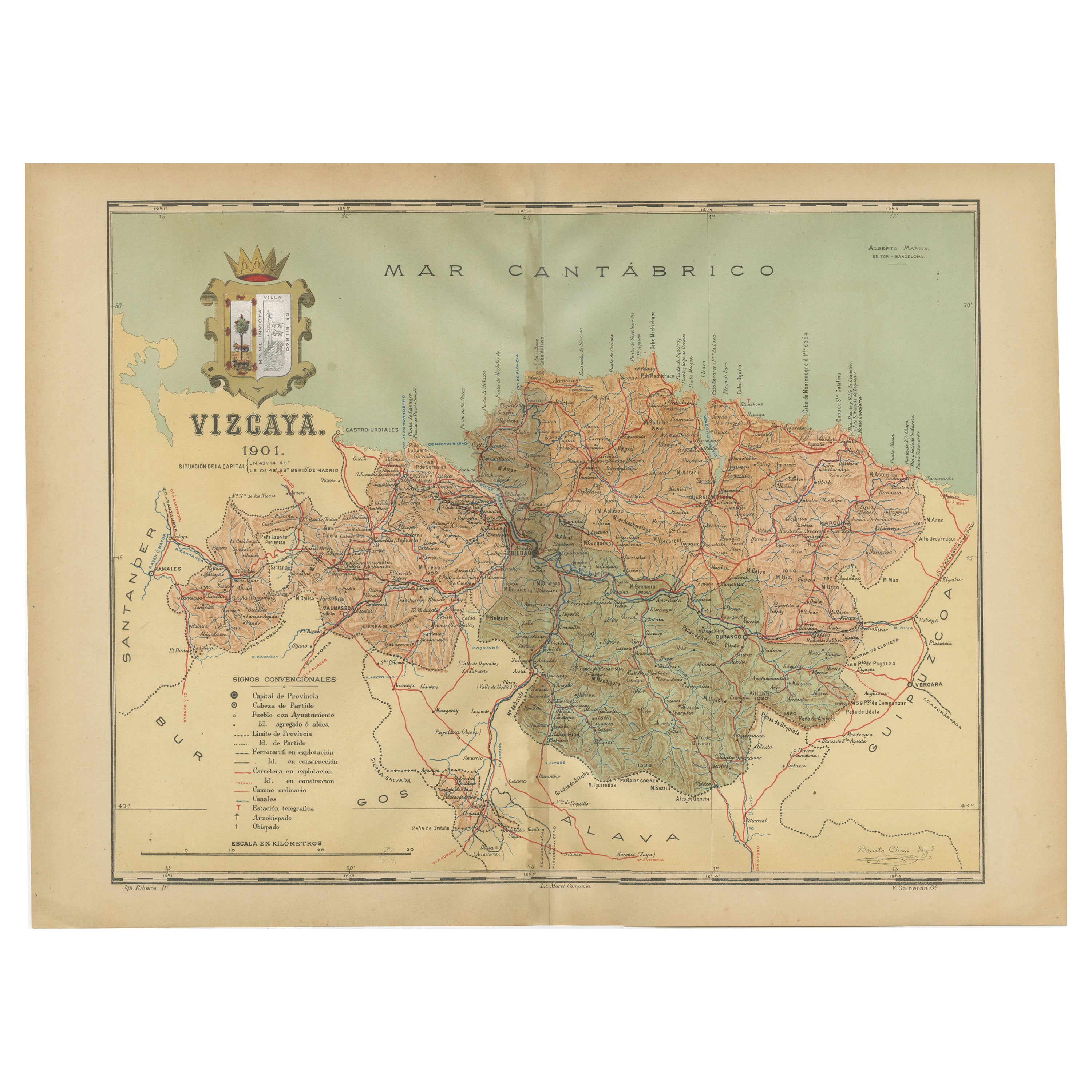
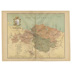
Cartographic Heritage: The 1901 Map of the Vizcaya Province in Spain
Located in Langweer, NL
This is a historical map of the province of Vizcaya (Biscay) in Spain, dated 1901. The title on the map is "VIZCAYA. 1901." It shows the topographical details of the region with cont...
Category
Antique Early 1900s Maps
Materials
Paper
$306 Sale Price
20% Off
Free Shipping
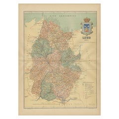
Lugo 1901: A Cartographic Chronicle of Galicia's Ancient Roman Walled City
Located in Langweer, NL
The map presents the province of Lugo, located in the autonomous community of Galicia in northwestern Spain, as it was in 1901. Notable features include:
- **Topography**: The provi...
Category
Antique Early 1900s Maps
Materials
Paper
$297 Sale Price
20% Off
Free Shipping
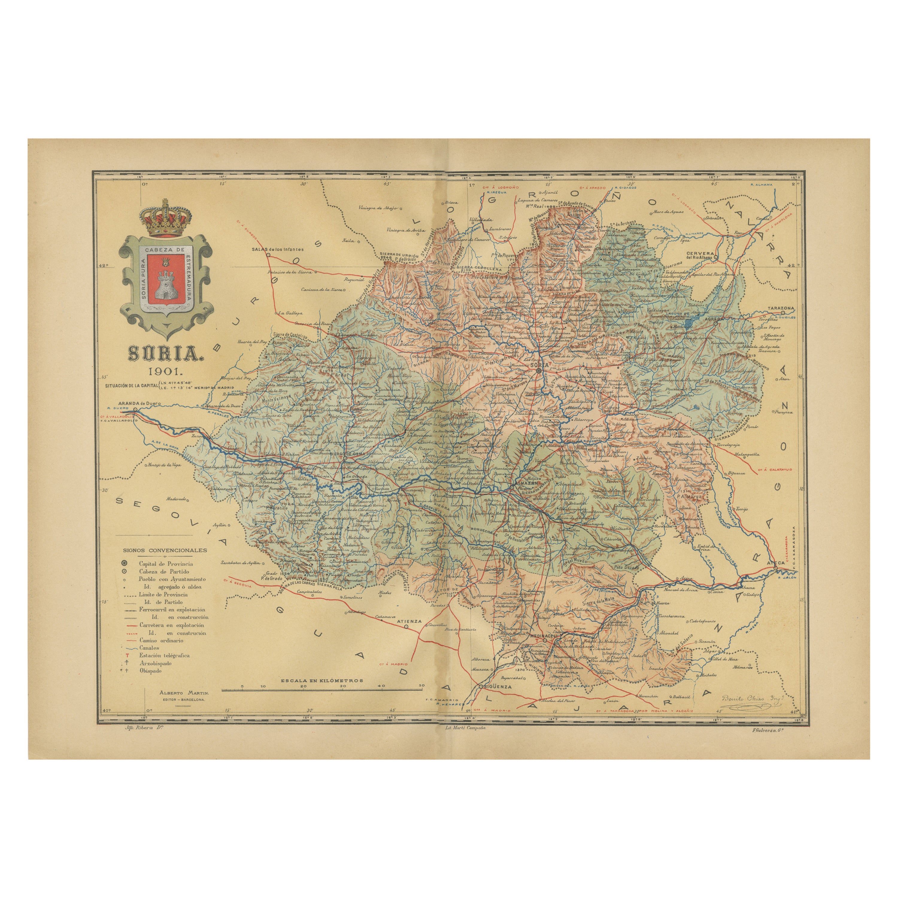
Map of Soria Province, 1901: Detailed Cartography of Northeastern Spain
Located in Langweer, NL
The map is a historical map of the province of Soria from 1901.
A decorative coat of arms enhances the aesthetic of the map, signifying the historical and cultural significance of ...
Category
Antique Early 1900s Maps
Materials
Paper

$316 Sale Price
20% Off
Free Shipping
Navarra in Cartographic Detail: A 1902 Map of the Crossroads of Northern Spain
Located in Langweer, NL
The original antique map for sale shows the Spanish province of Navarra as it was in 1902. Here's a brief description and a potential title for the map:
Description:
- The map detai...
Category
Antique Early 1900s Maps
Materials
Paper

$326 Sale Price
20% Off
Free Shipping
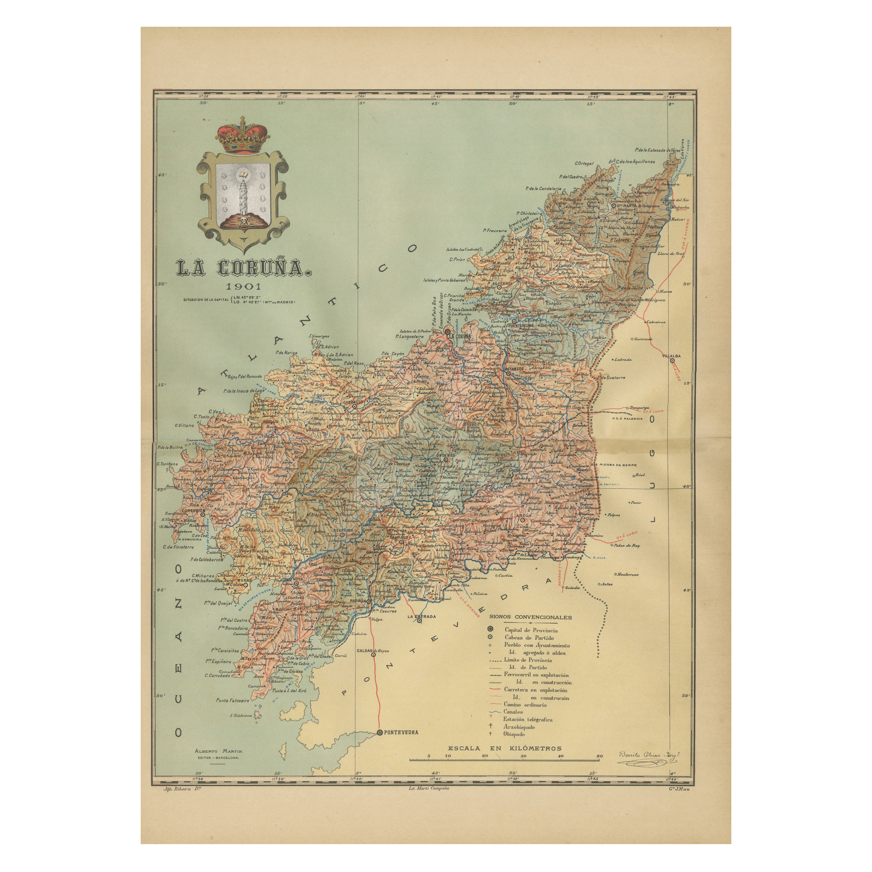
La Coruña 1901: A Cartographic View of Galicia's Maritime Province
Located in Langweer, NL
This antique map for sale showcases the province of La Coruña (in Galician, A Coruña), located in the northwest of Spain, within the autonomous community of Galicia, as of the year 1...
Category
Antique Early 1900s Maps
Materials
Paper

$354 Sale Price
20% Off
Free Shipping
You May Also Like
Large Original Vintage Map of Spain, circa 1920
Located in St Annes, Lancashire
Great map of Spain
Original color.
Good condition
Published by Alexander Gross
Unframed.
Category
Vintage 1920s English Maps
Materials
Paper

Large Original Antique Map of Madeira. 1894
Located in St Annes, Lancashire
Superb Antique map of Madeira
Published Edward Stanford, Charing Cross, London 1894
Original colour
Good condition
Unframed.
Free shipping
Category
Antique 1890s English Maps
Materials
Paper

Large Original Antique Map of The Canary Islands. 1894
Located in St Annes, Lancashire
Superb Antique map of The Canary Islands
Published Edward Stanford, Charing Cross, London 1894
Original colour
Good condition
Unframed.
Free shipping
Category
Antique 1890s English Maps
Materials
Paper

Large Original Antique Map of Cyprus. 1894
Located in St Annes, Lancashire
Superb Antique map of Cyprus
Published Edward Stanford, Charing Cross, London 1894
Original colour
Good condition
Unframed.
Free shipping
Category
Antique 1890s English Maps
Materials
Paper

Map of the Republic of Genoa
Located in New York, NY
Framed antique hand-coloured map of the Republic of Genoa including the duchies of Mantua, Modena, and Parma.
Europe, late 18th century.
Dimension: 25...
Category
Antique Late 18th Century European Maps

Geographical Antique Map of Principality of Monaco
By Bruno Santini
Located in Alessandria, Piemonte
ST/609 - Interesting antique color map of Monaco Principality in French language : "Carte qui contient le Principauté de Piémont, le Monferrat et la comté de...
Category
Antique Late 18th Century Italian Other Maps
Materials
Paper

More Ways To Browse
Used Furniture Oviedo
Antique Aerator
Antique Oushak
Mid Century Danish Directors Chairs
Moller 70
Argentina Travel Poster
Century Furniture Faux Bamboo
Early American Chairs
Hans Muller
Vintage Wood Table With Glass Top
19th Century Square Table
Antonio Bonet
Galle Chairs
Large Chinese Rug
1940s Vintage French Art Deco
20th Century Spanish Table
Antonio Bellini
Retro Fiberglass Furniture