Items Similar to Lugo 1901: A Cartographic Chronicle of Galicia's Ancient Roman Walled City


Want more images or videos?
Request additional images or videos from the seller
1 of 6
Lugo 1901: A Cartographic Chronicle of Galicia's Ancient Roman Walled City
$297.14
$371.4220% Off
£221.20
£276.5020% Off
€248
€31020% Off
CA$407.01
CA$508.7620% Off
A$452.68
A$565.8520% Off
CHF 236.38
CHF 295.4720% Off
MX$5,508.64
MX$6,885.8020% Off
NOK 3,018.88
NOK 3,773.6020% Off
SEK 2,831.18
SEK 3,538.9720% Off
DKK 1,887.94
DKK 2,359.9220% Off
Shipping
Retrieving quote...The 1stDibs Promise:
Authenticity Guarantee,
Money-Back Guarantee,
24-Hour Cancellation
About the Item
The map presents the province of Lugo, located in the autonomous community of Galicia in northwestern Spain, as it was in 1901. Notable features include:
- **Topography**: The province's terrain is depicted, which ranges from the coastal areas by the Cantabrian Sea to the mountainous interior regions.
- **Hydrography**: Blue lines likely represent the province's rivers, which would include the Miño, the province's main river, and its tributaries.
- **Transportation**: Red lines indicating roads and railways show the transport links within Lugo and to other regions.
- **Urban Centers**: Various symbols mark the locations of cities, towns, and villages, with the capital, also named Lugo, indicated.
- **Political Boundaries**: Dotted lines may show administrative boundaries within the province.
- **Legend**: The map contains a legend (Signos Convencionales) that explains the symbols used for provincial capitals, roads, railways, and other features.
- **Scale**: There is a scale in kilometers for distance measurement.
- **Coat of Arms**: The coat of arms of Lugo, featuring a chalice and a sacred host, is prominently displayed, symbolizing the province's cultural and historical heritage.
About the province of Lugo:
Lugo is renowned for its well-preserved Roman walls, which encircle the old town and are a UNESCO World Heritage site. The province is characterized by its lush green landscape, part of the Green Spain, and its relatively cool and wet climate. The economy of Lugo is traditionally based on agriculture and fishing, with dairy farming, beef production, and the cultivation of crops such as potatoes and corn being significant. The coastal areas are known for their high-quality seafood. Lugo is also a stop on the Camino Primitivo, one of the routes of the Camino de Santiago pilgrimage. The region's culture reflects a strong Celtic influence, evident in its music, folklore, and festivals such as the 'Arde Lucus', which celebrates the province's Roman history.
- Dimensions:Height: 20.08 in (51 cm)Width: 14.77 in (37.5 cm)Depth: 0 in (0.02 mm)
- Materials and Techniques:
- Period:1900-1909
- Date of Manufacture:1901
- Condition:Good condition. Central vertical folding lines as issued. Aged paper with typically warm, yellowish-brown hue, especially around the edges. Check the images carefully.
- Seller Location:Langweer, NL
- Reference Number:Seller: BG-13642-261stDibs: LU3054338032112
About the Seller
5.0
Recognized Seller
These prestigious sellers are industry leaders and represent the highest echelon for item quality and design.
Platinum Seller
Premium sellers with a 4.7+ rating and 24-hour response times
Established in 2009
1stDibs seller since 2017
2,510 sales on 1stDibs
Typical response time: <1 hour
- ShippingRetrieving quote...Shipping from: Langweer, Netherlands
- Return Policy
Authenticity Guarantee
In the unlikely event there’s an issue with an item’s authenticity, contact us within 1 year for a full refund. DetailsMoney-Back Guarantee
If your item is not as described, is damaged in transit, or does not arrive, contact us within 7 days for a full refund. Details24-Hour Cancellation
You have a 24-hour grace period in which to reconsider your purchase, with no questions asked.Vetted Professional Sellers
Our world-class sellers must adhere to strict standards for service and quality, maintaining the integrity of our listings.Price-Match Guarantee
If you find that a seller listed the same item for a lower price elsewhere, we’ll match it.Trusted Global Delivery
Our best-in-class carrier network provides specialized shipping options worldwide, including custom delivery.More From This Seller
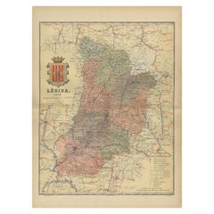
View AllLleida 1902: A Cartographic Perspective of Catalonia's Gateway to the Pyrenees
Located in Langweer, NL
The map for sale shows the province of Lleida, located in the western part of Catalonia, Spain, as of 1902. Here are the key features depicted on the map:
- **Topography**: The map ...
Category
Antique Early 1900s Maps
Materials
Paper
$287 Sale Price
20% Off
Free Shipping
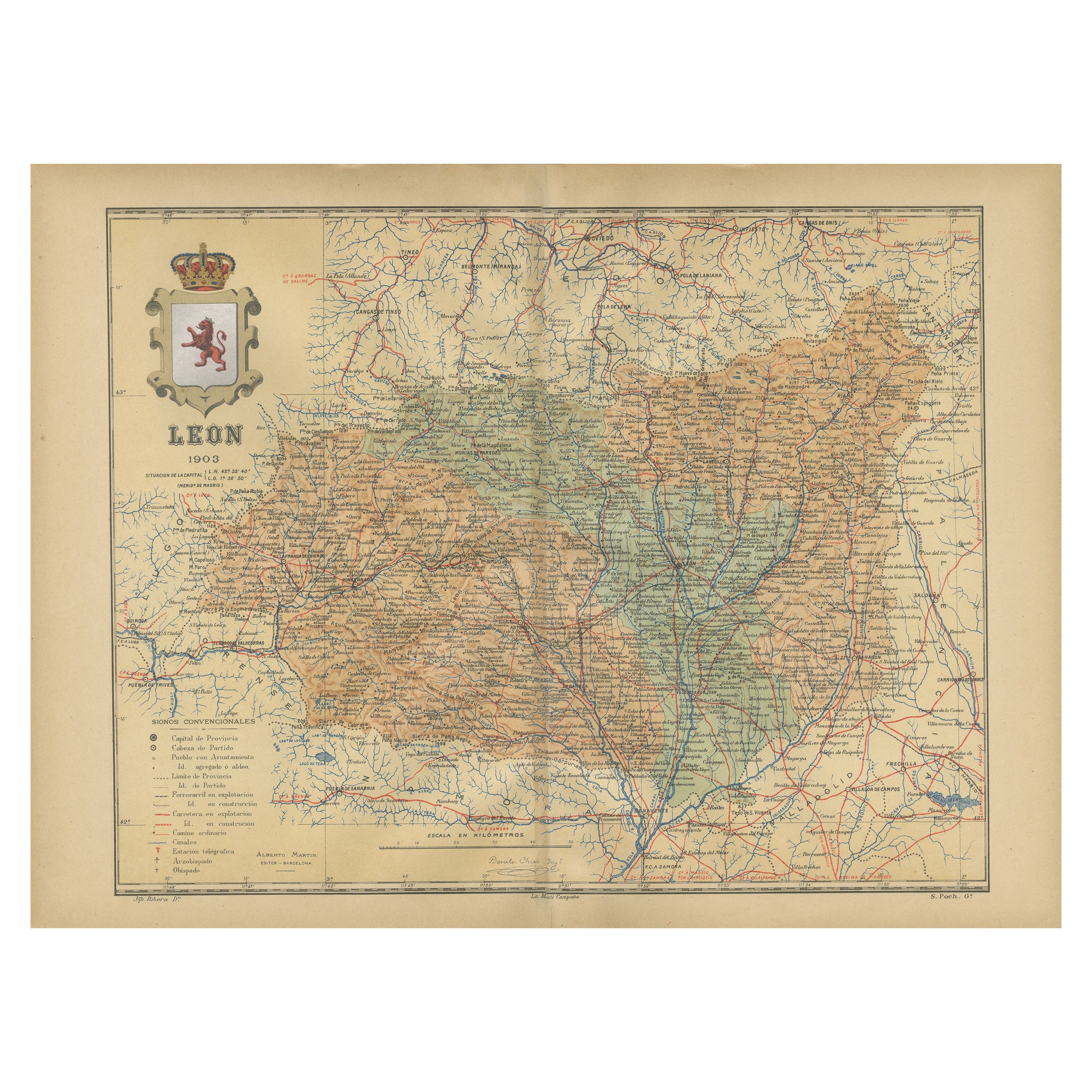
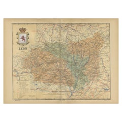
León 1903: A Cartographic Detailing of Castilla y León's Mountainous Province
Located in Langweer, NL
The map depicts the province of León, which is located in the northwest of Spain and forms part of the autonomous community of Castilla y León, as of 1903. Notable features of the ma...
Category
Antique Early 1900s Maps
Materials
Paper
$277 Sale Price
20% Off
Free Shipping
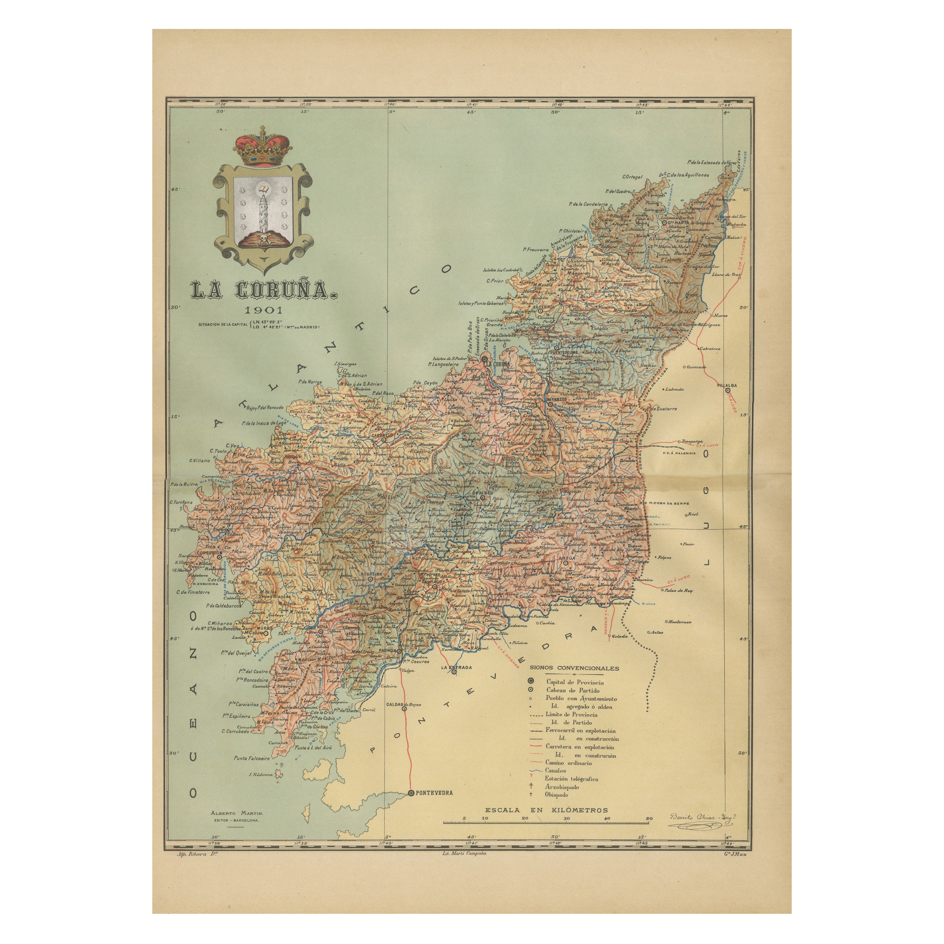
La Coruña 1901: A Cartographic View of Galicia's Maritime Province
Located in Langweer, NL
This antique map for sale showcases the province of La Coruña (in Galician, A Coruña), located in the northwest of Spain, within the autonomous community of Galicia, as of the year 1...
Category
Antique Early 1900s Maps
Materials
Paper

$354 Sale Price
20% Off
Free Shipping
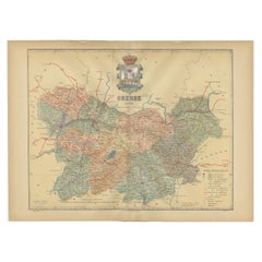
Orense in Depth: A 1902 Topographical Map of Galicia's Mountainous Province
Located in Langweer, NL
The map is a detailed cartographic representation of the province of Orense (Ourense in Galician), located in the northwest of Spain, as it was in 1902. Here's a brief description an...
Category
Antique Early 1900s Maps
Materials
Paper
$297 Sale Price
20% Off
Free Shipping
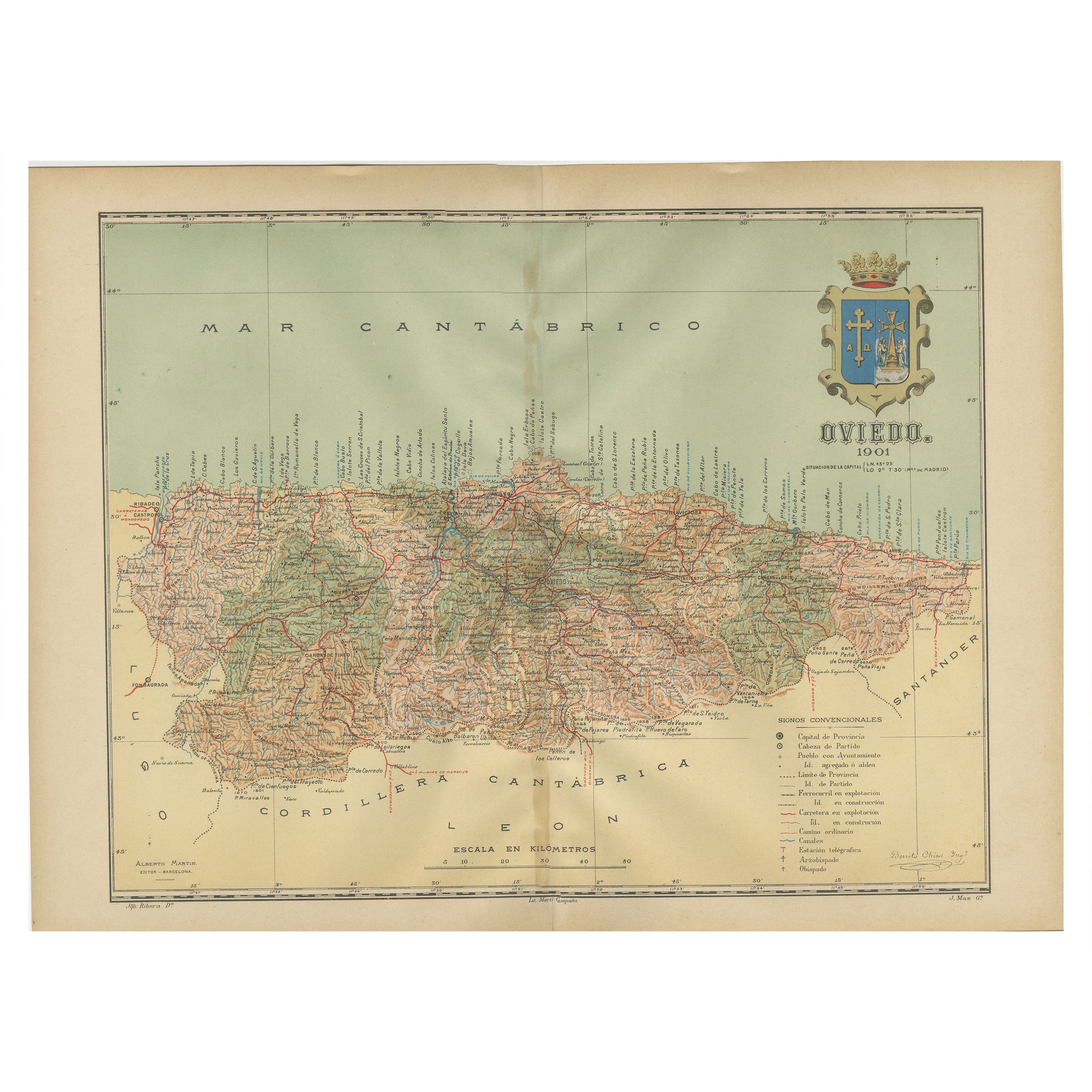
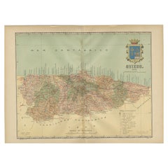
The Lay of the Land: A 1901 Topographic Map of Oviedo, Asturias
Located in Langweer, NL
The province depicted on the historical map on offer, Oviedo, corresponds to the modern-day autonomous community of Asturias in northwestern Spain. Here are some points about Asturia...
Category
Antique Early 1900s Maps
Materials
Paper
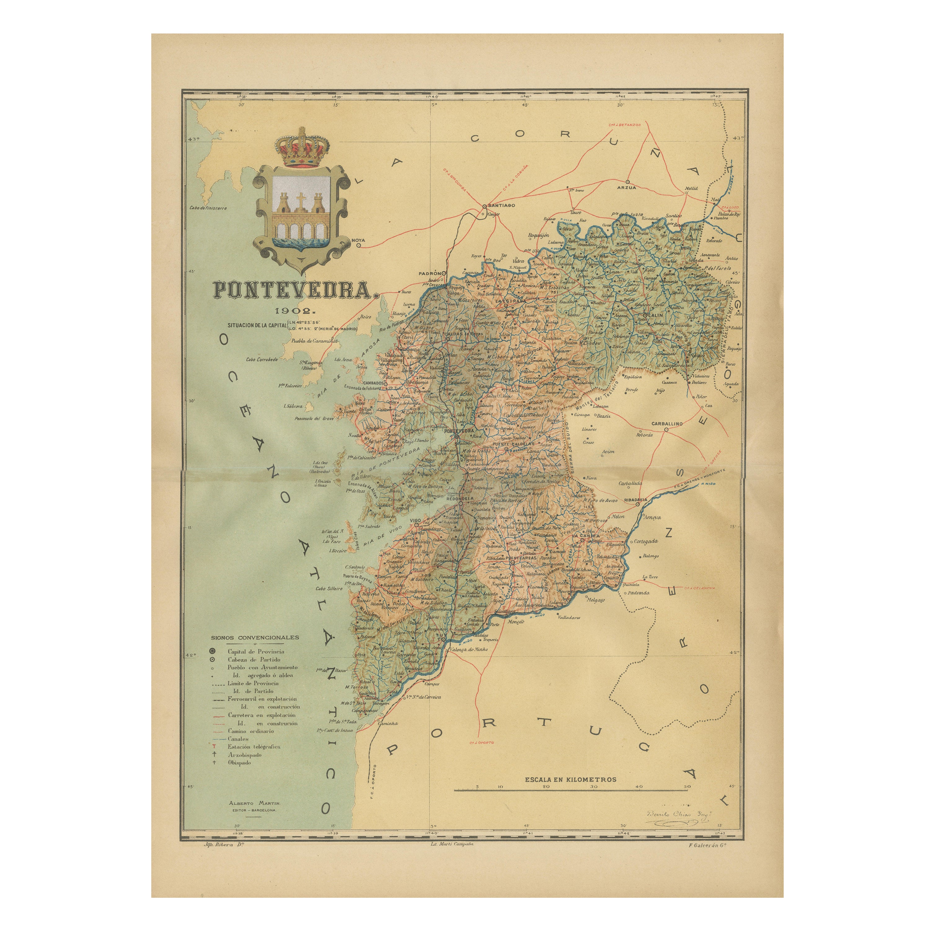
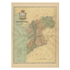
Cartographic Survey of Pontevedra, 1902: Crossroads of Galicia"
Located in Langweer, NL
This original old map of over 100 years old depicts the province of Pontevedra as it was in 1902. Pontevedra is located in the northwest of Spain, in the autonomous community of Galicia. This coastal province is bordered by the Atlantic Ocean to the west and Portugal to the south. It is a region known for its rugged coastline, which includes the famous Rías Baixas, a series of four estuarine inlets that are known for their scenic beauty, beaches, and seafood. The interior of the province is characterized by a hilly landscape that gradually rises from the coast to the interior.
Pontevedra's capital, which shares the same name, is renowned for its well-preserved old town, rich medieval history, and the iconic Sanctuary of the Pilgrim Virgin...
Category
Antique Early 1900s Maps
Materials
Paper
You May Also Like
Large Original Vintage Map of Spain, circa 1920
Located in St Annes, Lancashire
Great map of Spain
Original color.
Good condition
Published by Alexander Gross
Unframed.
Category
Vintage 1920s English Maps
Materials
Paper

Ancient National Atlas of France with Marengo
Located in Alessandria, Piemonte
Ancient National Atlas of France with the department of Marengo: a rare French etching dated 1806.
ST/178.
Category
Antique Early 19th Century French Other Prints
Materials
Paper

Geographical Antique Map of Principality of Monaco
By Bruno Santini
Located in Alessandria, Piemonte
ST/609 - Interesting antique color map of Monaco Principality in French language : "Carte qui contient le Principauté de Piémont, le Monferrat et la comté de...
Category
Antique Late 18th Century Italian Other Maps
Materials
Paper

Original Antique English County Map, Durham, J & C Walker, 1851
Located in St Annes, Lancashire
Great map of Durham
Original colour
By J & C Walker
Published by Longman, Rees, Orme, Brown & Co. 1851
Unframed.
Category
Antique 1850s English Other Maps
Materials
Paper
Large Original Antique Map of Lombardy and Venice, Italy. John Dower, 1861
Located in St Annes, Lancashire
Great map of Lombardy and Venice
Lithograph engraving by John Dower
Original colour
Published, 1861
Unframed
Good condition / crease to bottom left corner
Free shipping
Category
Antique 1860s English Victorian Maps
Materials
Paper

Original Antique Map of Spain and Portugal, circa 1790
Located in St Annes, Lancashire
Super map of Spain and Portugal
Copper plate engraving by A. Bell
Published, circa 1790.
Unframed.
Category
Antique 1790s English Other Maps
Materials
Paper

More Ways To Browse
Roman Capital
Railway Map
Antique Fishing Collectables
Chalice Used
Antique Potato
Antique Oushak
Mid Century Danish Directors Chairs
Moller 70
Argentina Travel Poster
Century Furniture Faux Bamboo
Early American Chairs
Hans Muller
Vintage Wood Table With Glass Top
19th Century Square Table
Antonio Bonet
Galle Chairs
Large Chinese Rug
1940s Vintage French Art Deco