Items Similar to Map of Soria Province, 1901: Detailed Cartography of Northeastern Spain


Want more images or videos?
Request additional images or videos from the seller
1 of 7
Map of Soria Province, 1901: Detailed Cartography of Northeastern Spain
$316.58
$395.7320% Off
£235.51
£294.3820% Off
€264
€33020% Off
CA$433.51
CA$541.8920% Off
A$482
A$602.5120% Off
CHF 251.68
CHF 314.6020% Off
MX$5,867.17
MX$7,333.9720% Off
NOK 3,211.28
NOK 4,014.1020% Off
SEK 3,008.82
SEK 3,761.0220% Off
DKK 2,009.69
DKK 2,512.1120% Off
Shipping
Retrieving quote...The 1stDibs Promise:
Authenticity Guarantee,
Money-Back Guarantee,
24-Hour Cancellation
About the Item
The map is a historical map of the province of Soria from 1901.
A decorative coat of arms enhances the aesthetic of the map, signifying the historical and cultural significance of Soria. The use of color is both functional and decorative, with blues likely representing water features, browns and greens for the land, and reds for main roads or boundaries.
Soria is a province located in the autonomous community of Castile and León in Spain. The map reflects the political and geographic understanding of the region at the beginning of the 20th century.
This map serves as both a navigational aid and a historical document, providing insights into the geography, infrastructure, and administrative organization of Soria at the time of its creation. The level of detail suggests it was designed for practical use, possibly by government officials or for civic planning.
Soria, a province in the autonomous community of Castile and León in Spain, is known for its rich historical heritage, natural beauty, and cultural significance. Traditionally, some of the main points of interest in the province of Soria would include:
1. **The City of Soria**: The provincial capital itself is a point of interest, with its historical architecture and cultural sites.
2. **Numancia**: An ancient Celtiberian settlement that is famous for its resistance against the Romans. The archaeological site near the village of Garray is a significant historical landmark.
3. **Monastery of San Juan de Duero**: An impressive monastery located on the banks of the river Duero, known for its unique cloister and mix of architectural styles.
4. **Hermitage of San Saturio**: Nestled into the side of a cliff and overlooking the river Duero, this hermitage is a peaceful retreat with beautiful frescoes.
5. **Plaza Mayor**: In the heart of Soria, the Plaza Mayor is a central spot for gatherings and is surrounded by important buildings.
6. **Iglesia de Santo Domingo**: A Romanesque church in Soria with a stunning façade, considered one of the best examples of Romanesque architecture in the province.
7. **Laguna Negra and the Urbión Glacial Lagoon**: A deep mountain lake surrounded by pine forests and steep cliffs, part of the natural park "Laguna Negra y Circos Glaciares de Urbión".
8. **Sierra de Cebollera Natural Park**: A mountainous area that offers numerous hiking trails and a variety of flora and fauna.
9. **The Río Lobos Canyon**: A striking natural canyon that provides a habitat for a variety of wildlife, as well as opportunities for hiking and exploration.
10. **Castillo de Gormaz**: One of the largest and longest fortresses in Europe, offering panoramic views of the surrounding countryside.
11. **El Burgo de Osma**: A historic town with a beautiful cathedral and a well-preserved medieval atmosphere.
12. **Alameda de Cervantes (La Dehesa)**: A large and well-maintained park in the city of Soria, perfect for a leisurely walk.
13. **Ruins of San Nicolás**: The ruins of this Romanesque church are a picturesque reminder of the past.
These sites reflect the historical importance and natural wonders of the province, attracting tourists interested in history, architecture, and nature.
- Dimensions:Height: 14.77 in (37.5 cm)Width: 20.08 in (51 cm)Depth: 0 in (0.02 mm)
- Materials and Techniques:
- Period:1900-1909
- Date of Manufacture:1901
- Condition:Good condition. Central vertical folding lines as issued. Aged paper with typically warm, yellowish-brown hue, especially around the edges and along the folding lines in the middle. Check the images carefully.
- Seller Location:Langweer, NL
- Reference Number:Seller: BG-13642-391stDibs: LU3054338032912
About the Seller
5.0
Recognized Seller
These prestigious sellers are industry leaders and represent the highest echelon for item quality and design.
Platinum Seller
Premium sellers with a 4.7+ rating and 24-hour response times
Established in 2009
1stDibs seller since 2017
2,510 sales on 1stDibs
Typical response time: <1 hour
- ShippingRetrieving quote...Shipping from: Langweer, Netherlands
- Return Policy
Authenticity Guarantee
In the unlikely event there’s an issue with an item’s authenticity, contact us within 1 year for a full refund. DetailsMoney-Back Guarantee
If your item is not as described, is damaged in transit, or does not arrive, contact us within 7 days for a full refund. Details24-Hour Cancellation
You have a 24-hour grace period in which to reconsider your purchase, with no questions asked.Vetted Professional Sellers
Our world-class sellers must adhere to strict standards for service and quality, maintaining the integrity of our listings.Price-Match Guarantee
If you find that a seller listed the same item for a lower price elsewhere, we’ll match it.Trusted Global Delivery
Our best-in-class carrier network provides specialized shipping options worldwide, including custom delivery.More From This Seller
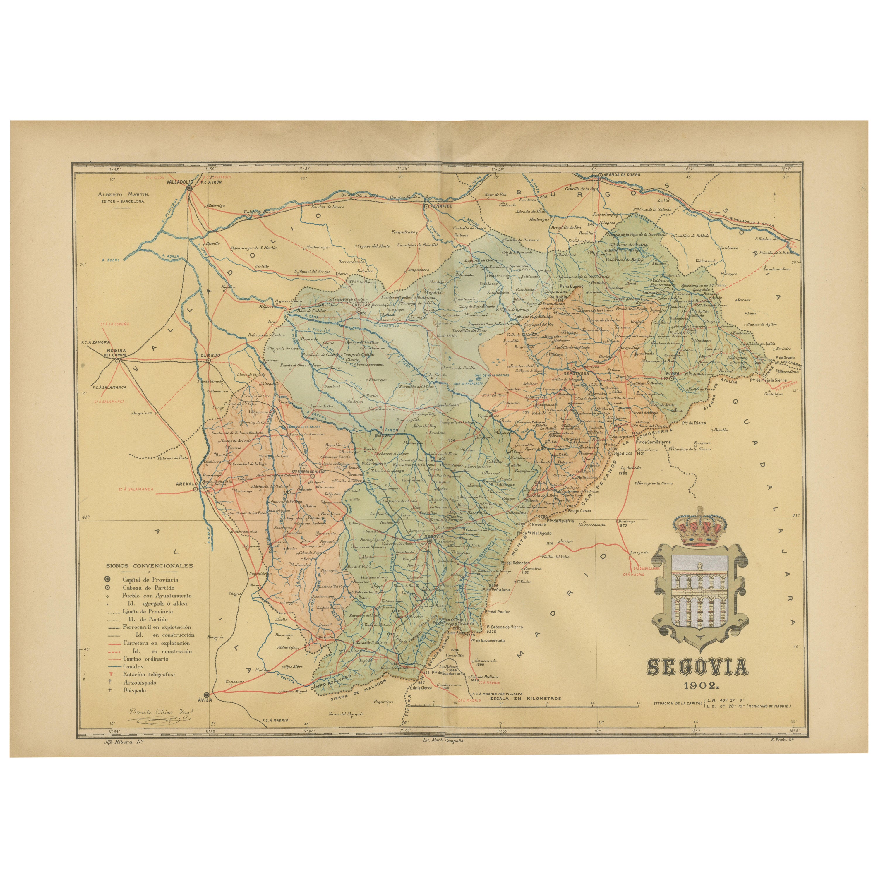
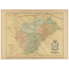
View AllTopographical and Administrative Cartography of Segovia in Spain, 1902
Located in Langweer, NL
An original old map of the province of Segovia from the year 1902. Segovia is a historic area located in the central part of Spain, northwest of Madrid. Known for its rich history, a...
Category
Antique Early 1900s Maps
Materials
Paper
$278 Sale Price
20% Off
Free Shipping
Navarra in Cartographic Detail: A 1902 Map of the Crossroads of Northern Spain
Located in Langweer, NL
The original antique map for sale shows the Spanish province of Navarra as it was in 1902. Here's a brief description and a potential title for the map:
Description:
- The map detai...
Category
Antique Early 1900s Maps
Materials
Paper

$326 Sale Price
20% Off
Free Shipping
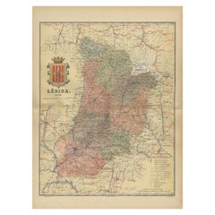
Lleida 1902: A Cartographic Perspective of Catalonia's Gateway to the Pyrenees
Located in Langweer, NL
The map for sale shows the province of Lleida, located in the western part of Catalonia, Spain, as of 1902. Here are the key features depicted on the map:
- **Topography**: The map ...
Category
Antique Early 1900s Maps
Materials
Paper
$287 Sale Price
20% Off
Free Shipping
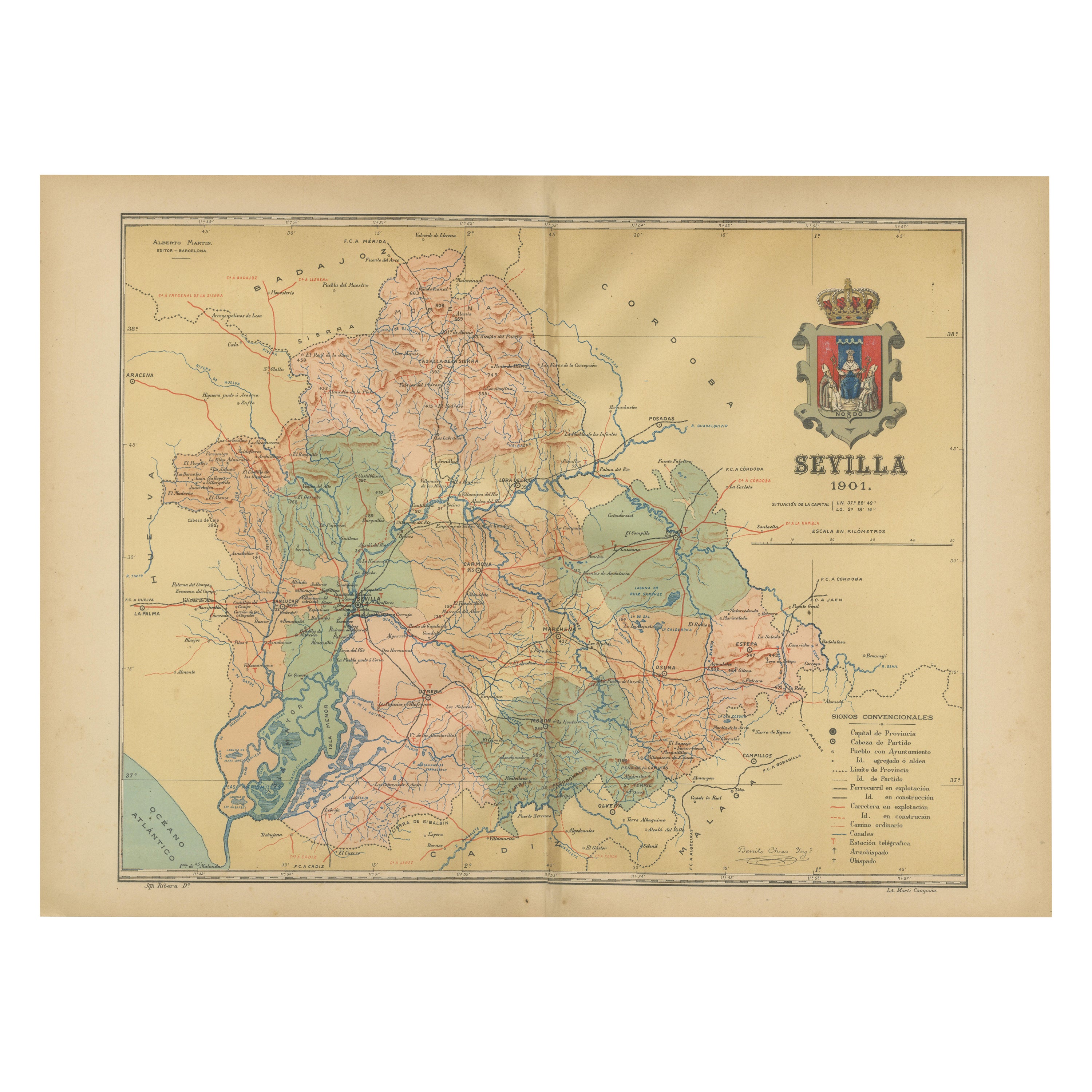
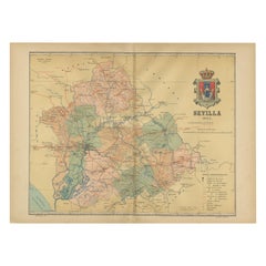
Map of Sevilla Province, 1901: A Depiction of The Spanish Cultural Heartland
Located in Langweer, NL
The print for sale here depicts a historical map of the province of Sevilla (Seville) from the year 1901. Sevilla is located in the southern part of Spain and is part of the autonomo...
Category
Antique Early 1900s Maps
Materials
Paper
$268 Sale Price
30% Off
Free Shipping
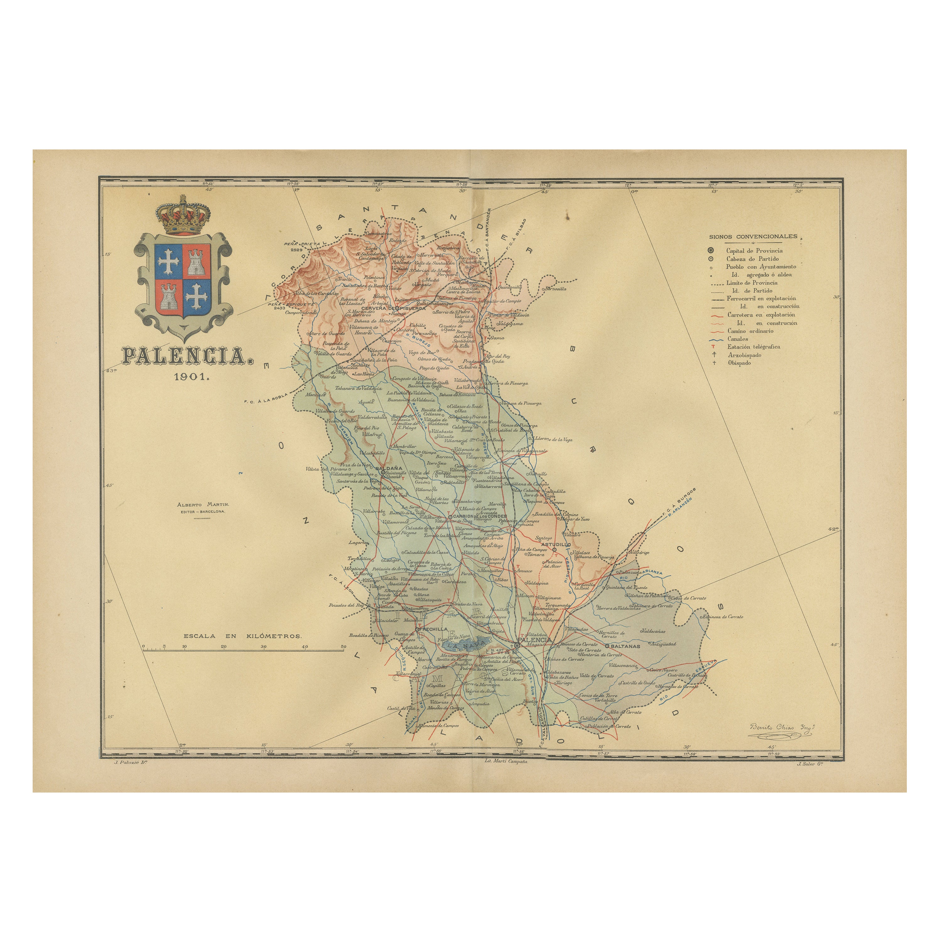
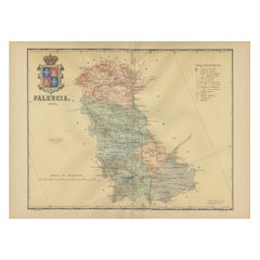
Original Antique Map of Palencia Province, in Northern Spain, 1901
Located in Langweer, NL
This historical map is of Palencia, a province in the northern part of Spain.
Palencia is situated within the autonomous community of Castilla y León. It is bordered by the provinc...
Category
Antique Early 1900s Maps
Materials
Paper
$374 Sale Price
20% Off
Free Shipping
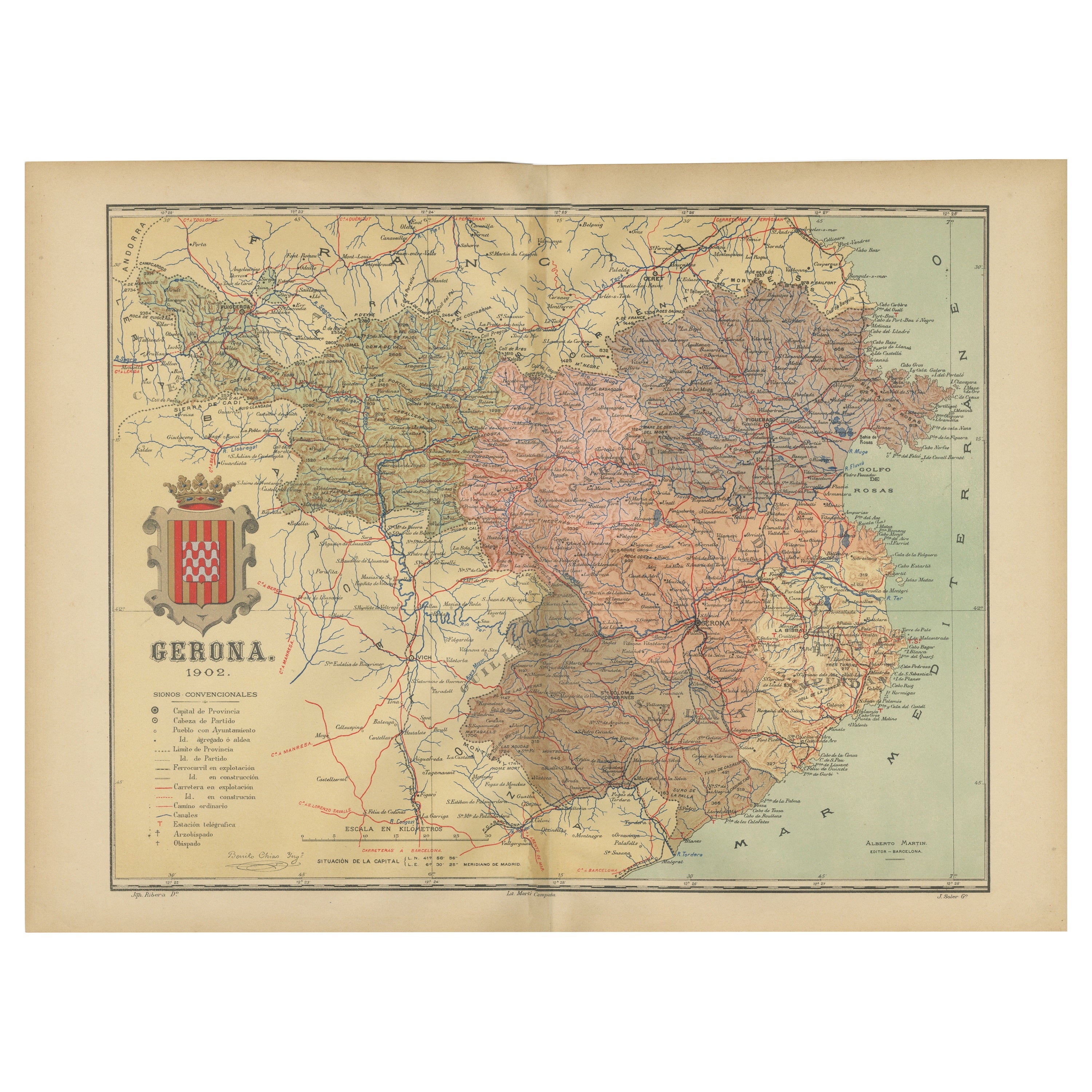
Girona 1902: Geographic and Infrastructural Map of Catalonia’s Northern Province
Located in Langweer, NL
The map provided is of the province of Girona (in Catalan, Girona), located in the northeast of Spain, within the autonomous community of Catalonia, as of the year 1902. Here are the...
Category
Antique Early 1900s Maps
Materials
Paper

$374 Sale Price
20% Off
Free Shipping
You May Also Like
Large Original Vintage Map of Spain, circa 1920
Located in St Annes, Lancashire
Great map of Spain
Original color.
Good condition
Published by Alexander Gross
Unframed.
Category
Vintage 1920s English Maps
Materials
Paper

Austria-Hungary, Western Part. Century Atlas antique vintage map
Located in Melbourne, Victoria
'The Century Atlas. Austria-Hungary, Western Part'
Original antique map, 1903.
Central fold as issued. Map name and number printed on the reverse corners.
Sheet 40cm by 29.5cm.
Category
Early 20th Century Victorian More Prints
Materials
Lithograph

1849 Map of "Europaische Russland", 'Meyer Map of European Russia', Ric. R017
Located in Norton, MA
1849 Map of
"Europaische Russland"
( Meyer Map of European Russia)
Ric.r017
A lovely map of European Russia dating to 1849 by Joseph Meyer. It covers the European portions of...
Category
Antique 19th Century Unknown Maps
Materials
Paper

Map of Eastern Roman Empire -Vintage Offset Print - Early 20th Century
Located in Roma, IT
This map of Eastern Roman Empire is a vintage offset print realized in the early 20th Century.
The state of preservation of the artwork is aged with dif...
Category
Early 20th Century Figurative Prints
Materials
Offset

Italy, Northern Part. Century Atlas antique vintage map
Located in Melbourne, Victoria
'The Century Atlas. Italy, Northern Part.'
Original antique map, 1903.
Central fold as issued. Map name and number printed on the reverse corners.
Sheet 29.5cm by 40cm.
Category
Early 20th Century Victorian More Prints
Materials
Lithograph

Map of Spain and Portugal - Original Etching - Late 19th Century
Located in Roma, IT
This Map of Spain and Portugal is an etching realized by an anonymous artist.
The state of preservation of the artwork is good with some small diffused stains.
Sheet dimension: 28...
Category
Late 19th Century Modern Figurative Prints
Materials
Etching

More Ways To Browse
Spanish Provincial
Spanish Santos
Antique Heart Pine
Antique Oushak
Mid Century Danish Directors Chairs
Moller 70
Argentina Travel Poster
Century Furniture Faux Bamboo
Early American Chairs
Hans Muller
Vintage Wood Table With Glass Top
19th Century Square Table
Antonio Bonet
Galle Chairs
Large Chinese Rug
1940s Vintage French Art Deco
20th Century Spanish Table
Antonio Bellini