Items Similar to Girona 1902: Geographic and Infrastructural Map of Catalonia’s Northern Province

Want more images or videos?
Request additional images or videos from the seller
1 of 6
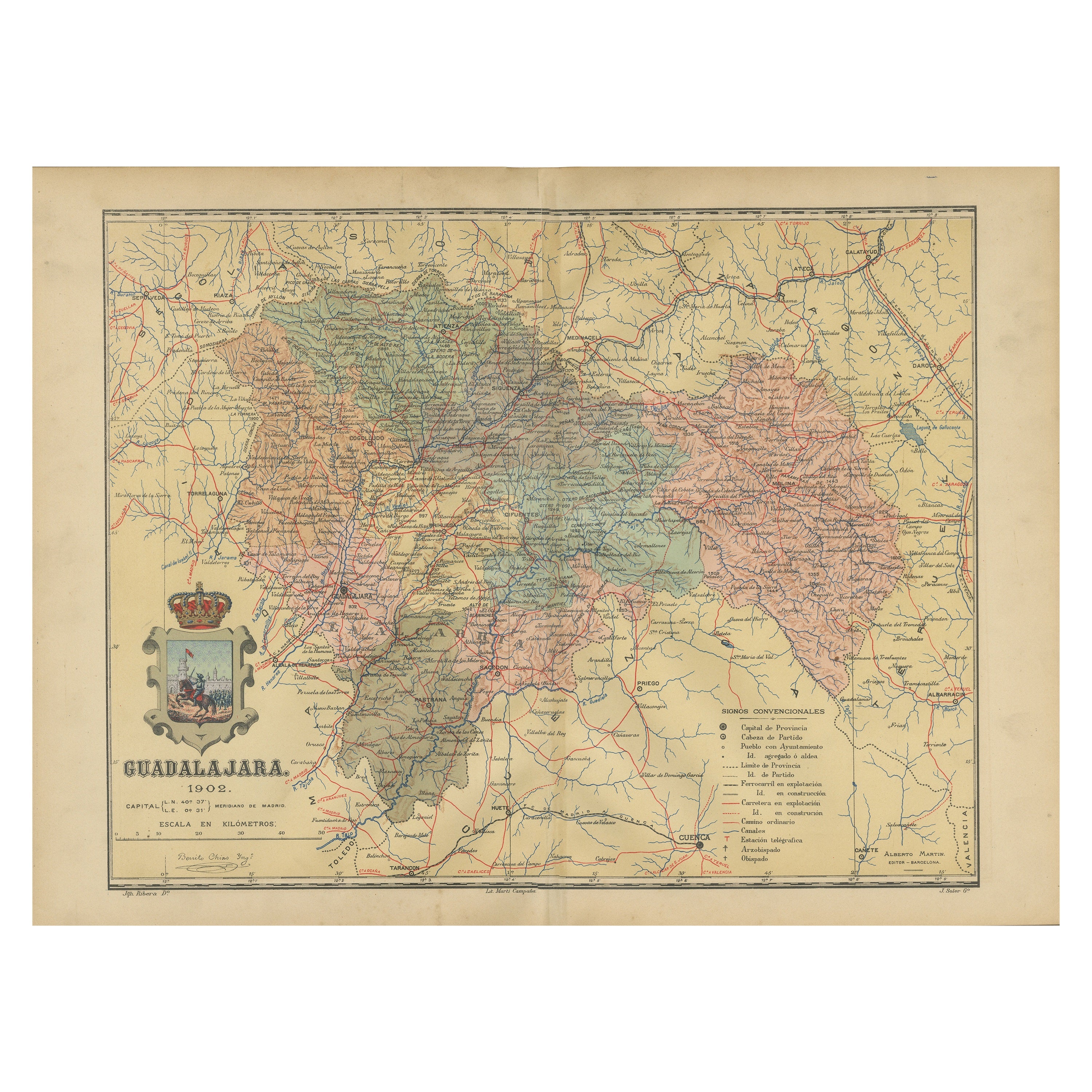
Girona 1902: Geographic and Infrastructural Map of Catalonia’s Northern Province
About the Item
The map provided is of the province of Girona (in Catalan, Girona), located in the northeast of Spain, within the autonomous community of Catalonia, as of the year 1902. Here are the key features:
The map details the mountainous landscape of the Pyrenees along the northern border and the more gentle relief towards the Mediterranean coast. It shows Girona's extensive coastline, including the Costa Brava, known for its rugged beauty and beaches.
Blue lines indicate rivers, likely including the Onyar, Ter, and Fluvia, which flow through the province. Red lines represent the transportation network of roads and railways, demonstrating the infrastructure connecting Girona's towns and cities. Symbols mark the locations of cities, towns, and villages, with the capital city, also named Girona, emphasized. Dotted lines may represent the administrative boundaries within Catalonia.
The coat of arms of Girona is prominently displayed, featuring elements that symbolize the province's heritage.
About the province of Girona:
Girona is known for its rich history, which includes Iberian, Greek, Roman, and Arab influences, as evidenced by the diverse architectural heritage found throughout the province. The capital city, Girona, has a well-preserved medieval quarter with historic baths and the Girona Cathedral. The province's landscape ranges from the Pyrenees mountains to the scenic Costa Brava. Girona is also known for its natural parks, such as the Cap de Creus, the Aiguamolls de l'Empordà, and part of the Garrotxa Volcanic Zone Natural Park. The region has a strong culinary reputation, with several renowned restaurants and a tradition of producing high-quality products like wine, olive oil, and seafood. The province's economy is diversified, including tourism, agriculture, and services.
- Dimensions:Height: 14.77 in (37.5 cm)Width: 20.08 in (51 cm)Depth: 0 in (0.02 mm)
- Materials and Techniques:
- Period:1900-1909
- Date of Manufacture:1901
- Condition:Good condition. Central vertical folding lines as issued. Aged paper with typically warm, yellowish-brown hue, especially around the edges. Check the images carefully.
- Seller Location:Langweer, NL
- Reference Number:
About the Seller
5.0
Platinum Seller
These expertly vetted sellers are 1stDibs' most experienced sellers and are rated highest by our customers.
Established in 2009
1stDibs seller since 2017
1,916 sales on 1stDibs
Typical response time: <1 hour
- ShippingRetrieving quote...Ships From: Langweer, Netherlands
- Return PolicyA return for this item may be initiated within 14 days of delivery.
More From This SellerView All
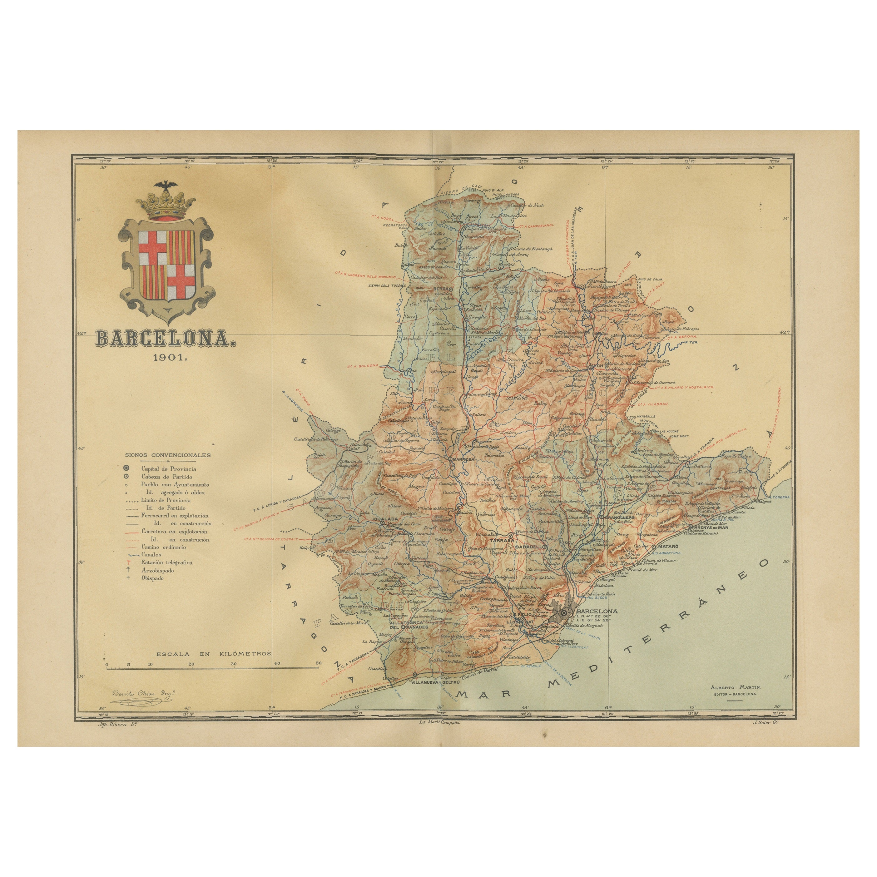
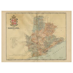
- Barcelona 1901: A Cartographic Portrait of Catalonia's Capital ProvinceLocated in Langweer, NLThis orignal antique map is a historical depiction of the province of Barcelona from 1901. It showcases the varied terrain of the province, with the Serra de Collserola ridge near the city of Barcelona and the Pyrenees to the north. The map includes the coastline along the Mediterranean Sea, indicating Barcelona's position as a coastal province. Blue lines indicate rivers, such as the Llobregat and Besòs, which are significant features in the province's geography. Dotted lines may signify the borders of the province within Catalonia. The coat of arms of Barcelona, highlighted with gold, is prominently displayed, featuring the Cross of Saint George (Cruz de Sant Jordi), the patron saint of Catalonia, and the red and yellow bars which are a symbol of the Aragonese and Catalan heritage. About the province of Barcelona: The province of Barcelona is part of the autonomous community of Catalonia in northeastern Spain. It is the most economically significant region of Catalonia, playing a crucial role in the country's economy due to its port, manufacturing, and service industries. The city of Barcelona is the capital and the second most populous city in Spain, known for its rich cultural heritage, architecture by Antoni Gaudí, such as the Sagrada Família, and its influential art scene. The province enjoys a Mediterranean climate and features diverse landscapes from the beaches along the coast to the mountains in the interior. Barcelona is also known for its vibrant festivals, cuisine, fashion, and sports, particularly football, being home to FC Barcelona...Category
Antique Early 1900s Maps
MaterialsPaper
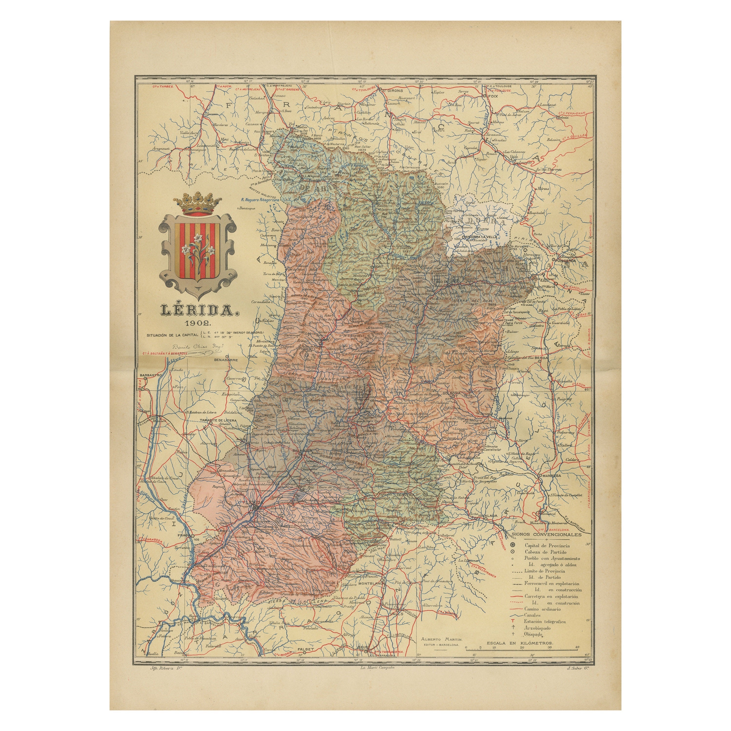
- Lleida 1902: A Cartographic Perspective of Catalonia's Gateway to the PyreneesLocated in Langweer, NLThe map for sale shows the province of Lleida, located in the western part of Catalonia, Spain, as of 1902. Here are the key features depicted on the map: - **Topography**: The map ...Category
Antique Early 1900s Maps
MaterialsPaper
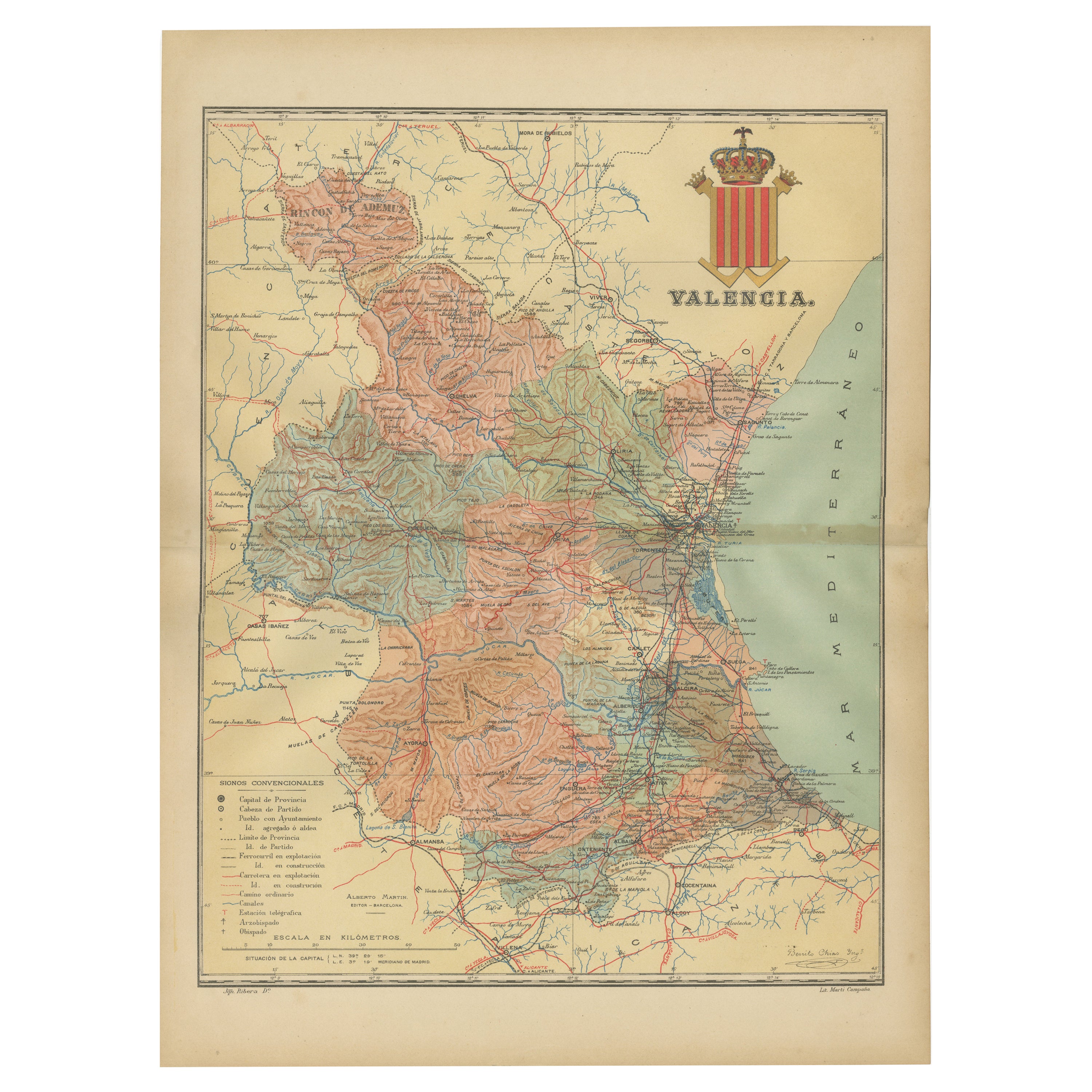
- Topographical and Infrastructure Map of the Province of Valencia, 1901Located in Langweer, NLA historical map of the province of Valencia, dated 1901. The map includes intricate details such as topographical features, with mountain ranges and river systems prominently marked...Category
Antique Early 1900s Maps
MaterialsPaper
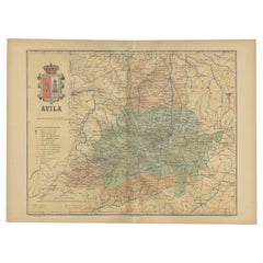
- Ávila in a Historical Map of 1902: A Geographic and Administrative OverviewLocated in Langweer, NLThe map is of the province of Ávila, one of the provinces of the autonomous community of Castile and León in Spain, and it is dated from 1902. The map illustrates several geographic ...Category
Antique Early 1900s Maps
MaterialsPaper
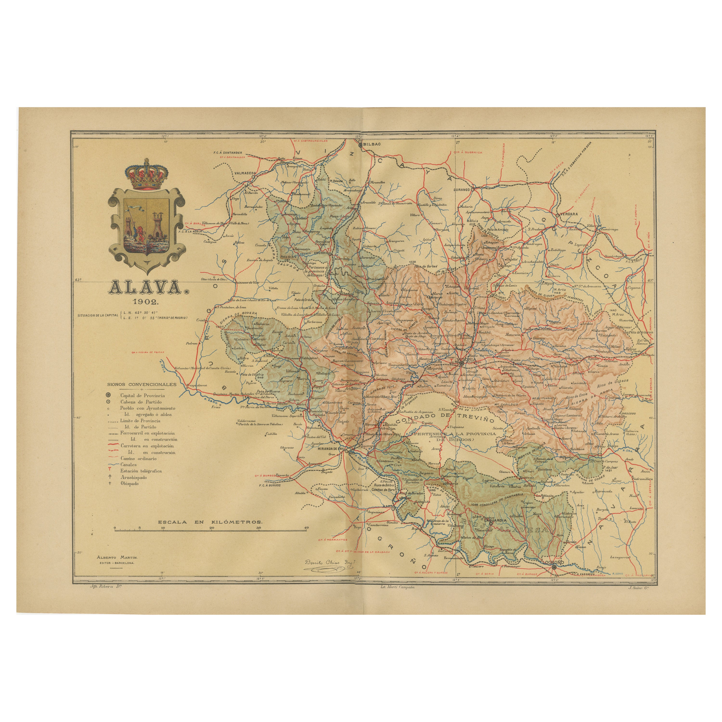
- Álava in Northern Spain: The Geography of Basque Heritage and Terrain, 1902Located in Langweer, NLThis original antique map is a historical depiction of the province of Álava (in Basque: Araba), which is one of the provinces of the Basque Country in northern Spain, as indicated b...Category
Antique Early 1900s Maps
MaterialsPaper
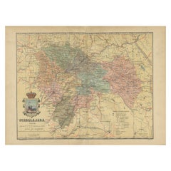
- Guadalajara 1902: A Cartographic Image of Castilla-La Mancha's Northern ProvinceLocated in Langweer, NLThe map illustrates the province of Guadalajara, part of the autonomous community of Castilla-La Mancha in Spain, as of 1902. The map includes various geographic and infrastructural ...Category
Antique Early 1900s Maps
MaterialsPaper


You May Also Like
- Geographical Antique Map of Principality of MonacoBy Bruno SantiniLocated in Alessandria, PiemonteST/609 - Interesting antique color map of Monaco Principality in French language : "Carte qui contient le Principauté de Piémont, le Monferrat et la comté de...Category
Antique Late 18th Century Italian Other Maps
MaterialsPaper
- Set of 4 Antique Geographical Maps French-German War 1870-71Located in Casale Monferrato, ITElegant late 19th century set of four antique geographical maps relating to the positioning of the armies in the Franco-German War 1870-71. A...Category
Antique 1890s Italian Maps
MaterialsPaper
- School Chart or Pull Down Map of Geography of the Netherlands, 1950sLocated in Hemiksem, VANA beautiful old school map of the Netherlands, painted on linen. The map shows the 3 different reliefs (low, middle, high) of the Netherlands. The beau...Category
Vintage 1950s Belgian Mid-Century Modern Maps
MaterialsLinen, Paint
- Antique 18th Century Map of the Province of Pensilvania 'Pennsylvania State'Located in Philadelphia, PAA fine antique of the colony of Pennsylvania. Noted at the top of the sheet as a 'Map of the province of Pensilvania'. This undated and anonymous map is thought to be from the Gentleman's Magazine, London, circa 1775, although the general appearance could date it to the 1760's. The southern boundary reflects the Mason-Dixon survey (1768), the western boundary is placed just west of Pittsburgh, and the northern boundary is not marked. The map has a number of reference points that likely refer to companion text and appear to be connected to boundaries. The western and southern boundaries are marked Q, R, S, for example. A diagonal line runs from the Susquehanna R to the Lake Erie P. A broken line marked by many letters A, B, N, O, etc., appears in the east. There are no latitude or longitude markings, blank verso. Framed in a shaped contemporary gilt wooden frame and matted under a cream colored matte. Bearing an old Graham Arader Gallery...Category
Antique 18th Century British American Colonial Maps
MaterialsPaper
- 1635 Willem Blaeu Map of Northern France"Comitatvs Bellovacvm" Ric.a08Located in Norton, MA1635 Willem Blaeu map of northern France, entitled. "Comitatvs Bellovacvm Vernacule Beavvais," Colored Ric.a008 “COMITATVS BELLOVACVM…” Amsterdam: W...Category
Antique 17th Century Unknown Maps
MaterialsPaper
- 1877 "Geological and Geographical Atlas of Colorado" by F. V. HaydenLocated in Colorado Springs, COThis is F. V. Hayden's Geological and Geographical Atlas of Colorado and Portions of Adjacent Territory, an unmatched geological record for its time. Published by the Department of the Interior in 1877, the Atlas of Colorado consists of twenty double elephant sized sheets, divided into two series. The first series, four sheets, embrace the entire area on a scale of twelve miles to an inch, and include Triangulations, Drainage, an Economic Map, and a General Geological map...Category
Antique 1870s American Maps
MaterialsPaper


Recently Viewed
View AllMore Ways To Browse
Map Of Old Armenia
Teak Wood Sphere
Nova Guinea Maps
Antique Map Of Illinois
Petite Point Hand Bag
Antique Map Of Southeastern Us
Antique Map Alabama
Antique Map Of Sydney
Malay Archipelago Map
Gambia Antique Map
Uruguay Antique Map
Guyana Antique Map
Ruscelli Map
Masque Theatre No
Nova Scotia Map
Antique Map Tuscany
Berkshire Antique Map
Cornwall Map