Items Similar to Old Colourful Decorative Map of Turkey in Europe, 1846


Want more images or videos?
Request additional images or videos from the seller
1 of 5
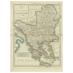
Old Colourful Decorative Map of Turkey in Europe, 1846
$220.38
$275.4820% Off
£163.32
£204.1520% Off
€184
€23020% Off
CA$300.87
CA$376.0820% Off
A$334.70
A$418.3820% Off
CHF 175.45
CHF 219.3220% Off
MX$4,089.97
MX$5,112.4620% Off
NOK 2,234.20
NOK 2,792.7420% Off
SEK 2,103.19
SEK 2,628.9820% Off
DKK 1,400.96
DKK 1,751.2020% Off
Shipping
Retrieving quote...The 1stDibs Promise:
Authenticity Guarantee,
Money-Back Guarantee,
24-Hour Cancellation
About the Item
Antique map titled 'Turkey in Europe'. Old map of Turkey in Europe.
This map originates from 'A New Universal Atlas Containing Maps of the various Empires, Kingdoms, States and Republics Of The World (..) by S.A. Mitchell.
Artists and Engravers: Samuel Augustus Mitchell was an American geographer. Mitchell worked as a teacher before turning to publishing geography textbooks and maps. He became involved in geography after teaching and realizing that there were so many poor quality geographical resources available to teachers. He was in Philadelphia when he founded his company. His son, S. Augustus Mitchell, became owner in 1860. Their publications covered all genres of geography: maps, travel guides, textbooks, and more.
- Dimensions:Height: 17.13 in (43.5 cm)Width: 13.78 in (35 cm)Depth: 0 in (0.02 mm)
- Materials and Techniques:
- Period:
- Date of Manufacture:1846
- Condition:Wear consistent with age and use. Condition: Good, original/contemporary hand coloring. Age-related toning and some wear, mainly in margins. Blank verso, please study image carefully.
- Seller Location:Langweer, NL
- Reference Number:Seller: BG-12418-34 1stDibs: LU3054327097622
About the Seller
5.0
Recognized Seller
These prestigious sellers are industry leaders and represent the highest echelon for item quality and design.
Platinum Seller
Premium sellers with a 4.7+ rating and 24-hour response times
Established in 2009
1stDibs seller since 2017
2,494 sales on 1stDibs
Typical response time: 1 hour
- ShippingRetrieving quote...Shipping from: Langweer, Netherlands
- Return Policy
Authenticity Guarantee
In the unlikely event there’s an issue with an item’s authenticity, contact us within 1 year for a full refund. DetailsMoney-Back Guarantee
If your item is not as described, is damaged in transit, or does not arrive, contact us within 7 days for a full refund. Details24-Hour Cancellation
You have a 24-hour grace period in which to reconsider your purchase, with no questions asked.Vetted Professional Sellers
Our world-class sellers must adhere to strict standards for service and quality, maintaining the integrity of our listings.Price-Match Guarantee
If you find that a seller listed the same item for a lower price elsewhere, we’ll match it.Trusted Global Delivery
Our best-in-class carrier network provides specialized shipping options worldwide, including custom delivery.More From This Seller
View AllAntique Map of Turkey in Europe by Wyld, '1845'
Located in Langweer, NL
Antique map titled 'Turkey in Europe'. Original antique map of Turkey in Europe. This map originates from 'An Atlas of the World, Comprehending S...
Category
Antique Mid-19th Century Maps
Materials
Paper

$191 Sale Price
20% Off
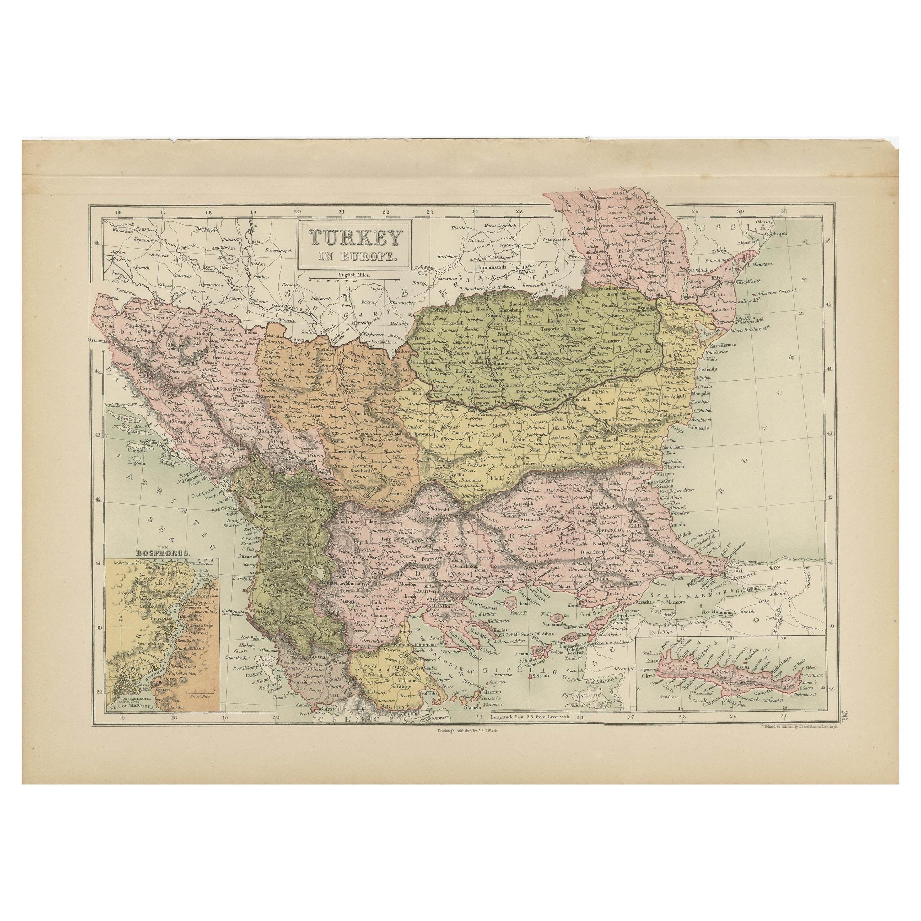
Antique Map of Turkey in Europe by A & C. Black, 1870
Located in Langweer, NL
Antique map titled 'Turkey in Europe'. Original antique map of Turkey in Europe with inset maps of the Bosporus and Crete or Candia. This map originates from ‘Black's General Atlas o...
Category
Antique Late 19th Century Maps
Materials
Paper
$167 Sale Price
20% Off
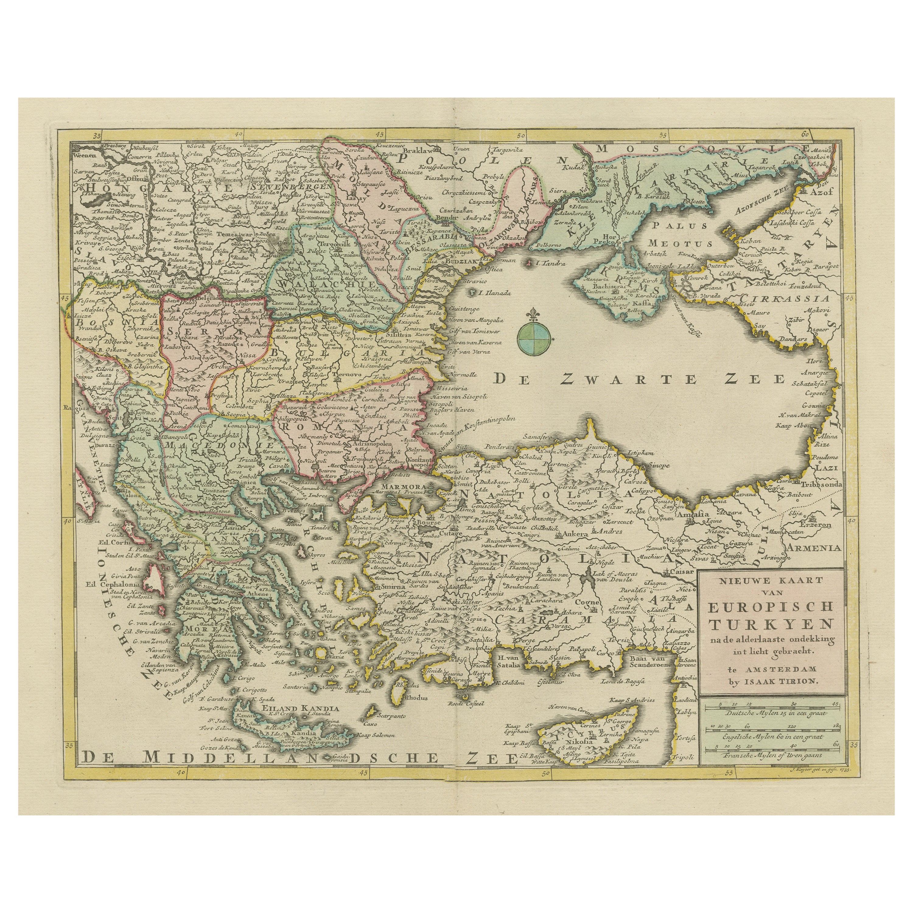
Antique Map of Greece, Turkey and surroundings with original coloring
Located in Langweer, NL
Antique map titled 'Nieuwe Kaart van Europisch Turkyen na de alderlaatste ontdekking in t licht gebracht'. Antique map of Greece with Crete and Cyprus, Turkey and the Black Sea. Publ...
Category
Antique Mid-18th Century Maps
Materials
Paper

$661 Sale Price
20% Off
Antique Map of Turkey and Greece by Petri, c.1873
Located in Langweer, NL
Antique map titled 'Europisch Turkije en Griekenland'. Old map depicting Turkey in Europe and Greece. This map originates from 'School-Atlas van alle Deelen der Aarde'.
Artists and...
Category
Antique 19th Century Maps
Materials
Paper

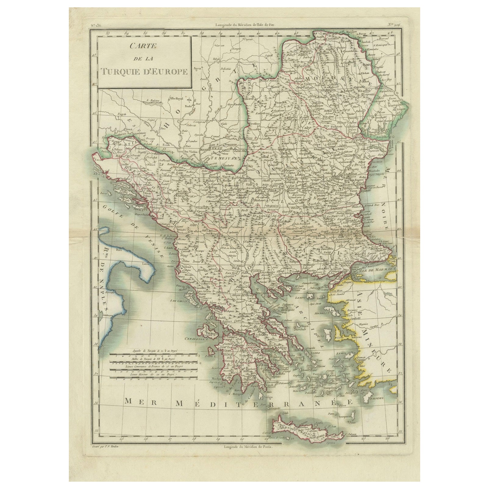
Genuine Antique Map of European Turkey by Pierre Antoine Tardieu (1784-1869)
Located in Langweer, NL
This is an original antique map titled "Carte de la Turquie d'Europe," which depicts the European territories of the Ottoman Empire. The map features detailed geographical and political boundaries, showcasing various regions, cities, rivers, and mountains within the Ottoman European territories. The map was created by Pierre Antoine Tardieu, a renowned French engraver, steel engraver, and cartographer known for his high-quality work.
Map Details:
- **Title**: Carte de la Turquie d'Europe
- **Creator**: Pierre Antoine Tardieu (1784-1869)
- **Publication Date**: Early 19th century
- **Dimensions**: Approximately 34.5 x 43.5 cm (13.5 x 17.25 inches)
- **Features**: The map includes a detailed representation of the European territories of the Ottoman Empire, with place names, rivers, mountains, and regions clearly marked. The title cartouche is located in the upper left corner, and the mile scale is presented in the lower left.
Around the year 1800, the region referred to as "European Turkey" or "Ottoman Europe" was a significant part of the Ottoman Empire, which was one of the most powerful empires in the world at the time. Here are some key aspects of European Turkey during this period:
### Geographic Scope
European Turkey included a large part of Southeastern Europe, encompassing modern-day:
- Greece
- Bulgaria
- Romania (specifically the regions of Dobruja and parts of Wallachia)
- Serbia
- Albania
- Montenegro
- Bosnia and Herzegovina
- Parts of Croatia, Macedonia, and Hungary
Political Structure
- **Ottoman Administration**: The region was governed by the Ottoman administrative system, which divided territories into provinces (vilayets) and smaller administrative units (sanjaks). Each province was overseen by a governor (pasha) appointed by the Sultan.
- **Autonomy and Vassal States**: Some areas within European Turkey had varying degrees of autonomy or were vassal states. For example, Wallachia and Moldavia (in modern-day Romania) were vassal principalities that retained local rulers under Ottoman suzerainty.
Society and Demographics
- **Ethnic Diversity**: The region was extremely diverse, home to numerous ethnic groups, including Turks, Greeks, Bulgarians, Serbs, Albanians, Vlachs (Romanians), and Jews, among others.
- **Religious Diversity**: There was significant religious diversity, with Islam being the dominant religion due to Ottoman rule, but large Christian (Eastern Orthodox, Roman Catholic) and Jewish populations coexisted.
Economy
- **Agriculture**: The economy was largely agrarian, with agriculture being the primary occupation. Key crops included grains, tobacco, and cotton.
- **Trade and Commerce**: European Turkey was strategically important for trade, connecting the Mediterranean with Central Europe and the Black Sea. Major cities like Constantinople (modern-day Istanbul), Thessaloniki, and Belgrade were key commercial hubs.
Culture
- **Cultural Influence**: The region was a melting pot of various cultures, influenced by Byzantine, Slavic, and Ottoman traditions. This mix was reflected in architecture, cuisine, music, and customs.
- **Education and Language**: The official language of administration was Ottoman Turkish, but many local languages were spoken. Education was often conducted in religious institutions, with different communities maintaining their own schools.
Challenges and Conflicts
- **Internal Strife**: The Ottoman Empire faced numerous internal challenges, including administrative inefficiency, corruption, and local uprisings.
- **External Threats**: The empire was also under pressure from external forces, particularly from the Habsburg Empire, Russia, and later from nationalist movements within the Balkans, which sought independence or autonomy from Ottoman rule.
Decline of Ottoman Power
By 1800, the Ottoman Empire was experiencing a gradual decline, which would intensify throughout the 19th century. This period saw increasing nationalist sentiments among various ethnic groups within European Turkey, leading to uprisings and eventual wars of independence, such as the Serbian Revolution (1804-1835) and the Greek War of Independence (1821-1829).
Overall, European Turkey around 1800 was a complex and diverse region under the Ottoman Empire's waning control, characterized by a rich tapestry of cultures, economic activities, and political structures.
Condition Overview:
1. **Paper Quality**: The map exhibits signs of aging, such as yellowing along the edges, which is typical for documents of this age. The paper remains in good condition without major tears or damage.
2. **Edges and Corners**: The edges are slightly worn, with minor fraying and a few small tears that do not significantly impact the map's readability or aesthetic value.
3. **Center Fold**: There is a visible center fold, common for maps that were folded for storage or publication. The fold is in good condition without significant wear but with splits on both sidess.
4. **Color and Print Quality**: The colors used to outline the boundaries remain vibrant and clear. The print quality is excellent, with sharp, legible text and detailed illustrations.
5. **Staining and Spots**: There are a few spots and stains, particularly near the edges and along the fold. These do not obscure any critical details of the map.
Historical and Artistic Value:
Pierre Antoine Tardieu was known for his meticulous craftsmanship and contributions to cartography. His work drew the attention of prominent figures such as Alexander von Humboldt...
Category
Antique Early 1800s Maps
Materials
Paper
$373 Sale Price
20% Off
Antique Map of Turkey and Greece, 1852
Located in Langweer, NL
Antique map titled 'Europisch Turkije en Griekenland'. Map of Turkey in Europe and Greece. This map originates from 'School-Atlas van alle deelen der Aar...
Category
Antique 19th Century Maps
Materials
Paper

$114 Sale Price
20% Off
You May Also Like
Hand-Colored 18th Century Homann Map of the Danube, Italy, Greece, Croatia
By Johann Baptist Homann
Located in Alamo, CA
"Fluviorum in Europa principis Danubii" is a hand colored map of the region about the Danube river created by Johann Baptist Homann (1663-1724) in his 'Atlas Novus Terrarum', publish...
Category
Antique Early 18th Century German Maps
Materials
Paper

Hand-Colored 18th Century Homann Map of the Black Sea, Turkey and Asia Minor
By Johann Baptist Homann
Located in Alamo, CA
An attractive original early 18th century hand-colored map of the Black Sea and Turkey entitled "Carte de L'Asie Minevre ou de la Natolie et du Pont Evxin Tiree des Voyages et des Ob...
Category
Antique Early 18th Century German Maps
Materials
Paper

Greece, "Graeciae Antiquae"" A 17th Century Hand-colored Map by Sanson
By Nicolas Sanson
Located in Alamo, CA
This is an original 17th century hand colored copperplate engraved map of Greece entitled "Graeciae Antiquae Tabula Hanc Geographicam" by Nicolas d'Abbeville Sanson, engraved and pub...
Category
Antique Mid-17th Century French Maps
Materials
Paper

Large Original Antique Map of Cyprus. 1894
Located in St Annes, Lancashire
Superb Antique map of Cyprus
Published Edward Stanford, Charing Cross, London 1894
Original colour
Good condition
Unframed.
Free shipping
Category
Antique 1890s English Maps
Materials
Paper

Original Antique Map of Ancient Greece, Achaia, Corinth, 1786
Located in St Annes, Lancashire
Great map of Ancient Greece. Showing the region of Thessaly, including Mount Olympus
Drawn by J.D. Barbie Du Bocage
Copper plate engraving by P.F Tardieu
Original hand color...
Category
Antique 1780s French Other Maps
Materials
Paper

Map of Ancient Greece of Macedonia and... - Lithograph by Auguste Wahlen - 1844
Located in Roma, IT
Map of Ancient Greece of Macedonia and Thrace is a lithograph made by Auguste Wahlen in 1844.
Hand colored.
Good condition.
Bottom left is the original title "Carta della Grecia A...
Category
1840s Modern Figurative Prints
Materials
Lithograph

More Ways To Browse
In Europe
Antique Map Of Turkish Empire
Arnold And Son
Indianapolis Antique Furniture
Antique Map Of Jerusalem
Antique Maps Of Sicily
Antique Celestial Maps
Antique Compass Maritime Compasses
Bengal Map
J C Walker Map
Map Of Ancient Greece
Ptolemy Map
Antique Marine Compass
Map Of Jerusalem
1820 World Map
Cyprus Antique Maps
Antique Ecuador
Antique Map Of Thailand