Items Similar to Old Original Map of Pozzuoli Near Naples in the Campania Region, Italy, ca.1740
Want more images or videos?
Request additional images or videos from the seller
1 of 5
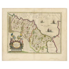
Old Original Map of Pozzuoli Near Naples in the Campania Region, Italy, ca.1740
$330.01
$412.5220% Off
£248.57
£310.7120% Off
€280
€35020% Off
CA$455.10
CA$568.8820% Off
A$511.29
A$639.1120% Off
CHF 267.15
CHF 333.9420% Off
MX$6,240.52
MX$7,800.6520% Off
NOK 3,392.01
NOK 4,240.0220% Off
SEK 3,192.87
SEK 3,991.0820% Off
DKK 2,131.25
DKK 2,664.0720% Off
About the Item
Antique map titled 'Hic Jacent Puteolorum Bajarum (..)'. Old map of the region of Pozzuoli showing the topographic and architectural features of interest. Pozzuoli is a city and comune of the Metropolitan City of Naples, in the Italian region of Campania. Source unknown, to be determined.
Artists and Engravers: Anonymous.
Condition: Very good, general age-related toning. Minor wear, blank verso. Please study image carefully.
- Dimensions:Height: 9.65 in (24.5 cm)Width: 13.19 in (33.5 cm)Depth: 0 in (0.02 mm)
- Materials and Techniques:
- Period:1740-1749
- Date of Manufacture:circa 1740
- Condition:
- Seller Location:Langweer, NL
- Reference Number:Seller: BG-12279-5 1stDibs: LU3054326675582
About the Seller
5.0
Recognized Seller
These prestigious sellers are industry leaders and represent the highest echelon for item quality and design.
Platinum Seller
Premium sellers with a 4.7+ rating and 24-hour response times
Established in 2009
1stDibs seller since 2017
2,533 sales on 1stDibs
Typical response time: <1 hour
- ShippingRetrieving quote...Shipping from: Langweer, Netherlands
- Return Policy
Authenticity Guarantee
In the unlikely event there’s an issue with an item’s authenticity, contact us within 1 year for a full refund. DetailsMoney-Back Guarantee
If your item is not as described, is damaged in transit, or does not arrive, contact us within 7 days for a full refund. Details24-Hour Cancellation
You have a 24-hour grace period in which to reconsider your purchase, with no questions asked.Vetted Professional Sellers
Our world-class sellers must adhere to strict standards for service and quality, maintaining the integrity of our listings.Price-Match Guarantee
If you find that a seller listed the same item for a lower price elsewhere, we’ll match it.Trusted Global Delivery
Our best-in-class carrier network provides specialized shipping options worldwide, including custom delivery.More From This Seller
View AllAntique Map of Southern Italy by Janssonius, C.1650
Located in Langweer, NL
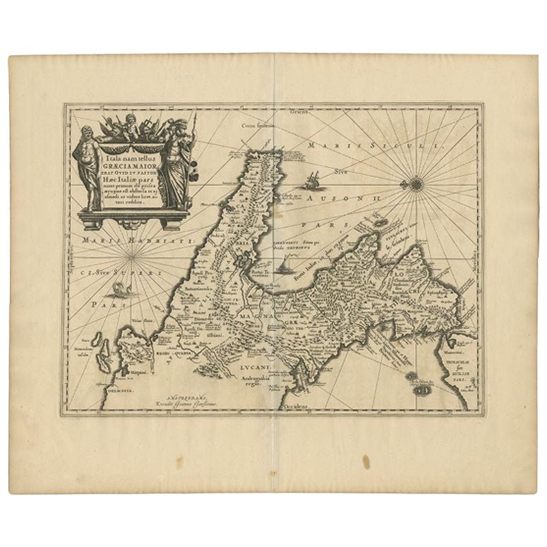
"Antique map titled 'Itala nam tellus Graecia Maior erat Ovid. IV. Fastor. Haec Italiae pars nunc primum de prica aerugine est abstersa (..)'. Beautiful map of Southern Italy...
Category
Antique 17th Century Maps
Materials
Paper

$697 Sale Price
20% Off
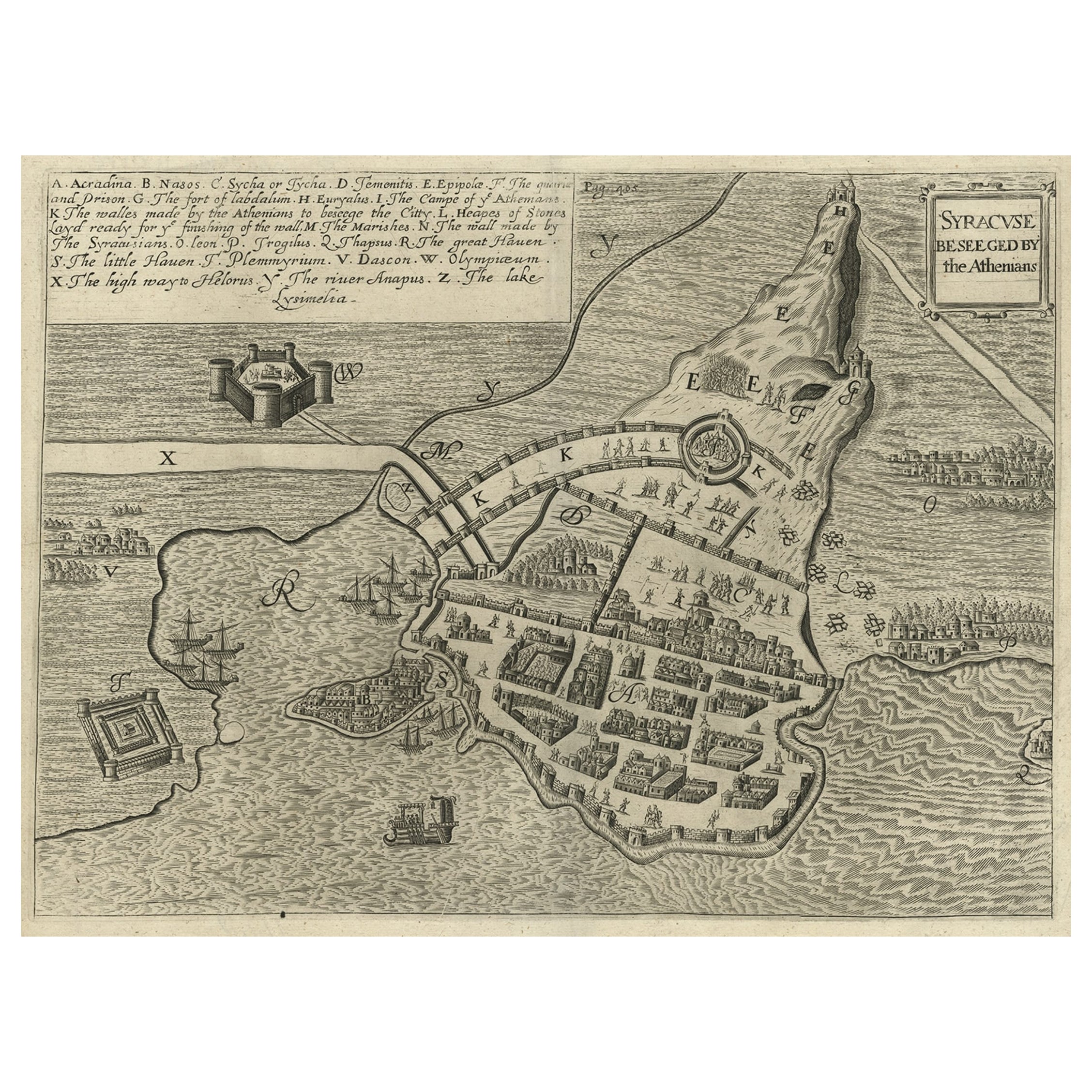
Antique Map of the Siege of Syracuse, Sicilia, Italy, 'ca.1675'
Located in Langweer, NL
Antique map titled 'Syracus beseeged by the Athenians.' This original uncommon antique map shows the siege of Syracuse, Italy, by the Athenians. Key top left.
The siege of Syracus...
Category
Antique 1670s Maps
Materials
Paper
$697 Sale Price
20% Off
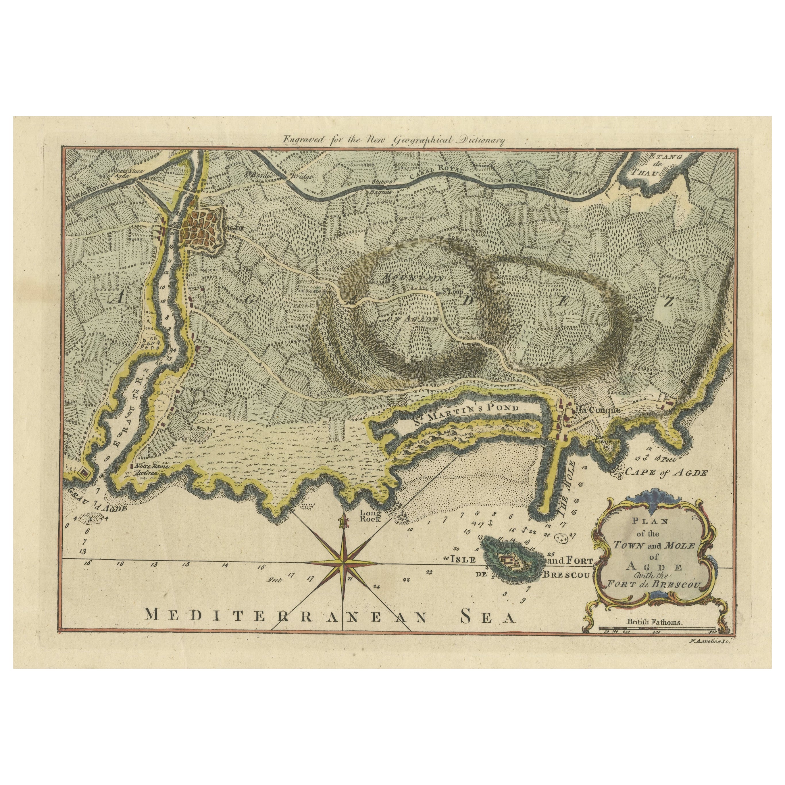
Antique Map Plan of Town and Mole of CAP D'agde & Fort De Brescou, France, 1759
Located in Langweer, NL
Antique Plan titled 'Plan of the Town and Mole of Agde with the Fort de Brescou'. Antique town plan of Agde, engraved for the Geographical Dictionary, by Rol...
Category
Antique Mid-18th Century Maps
Materials
Paper
$462 Sale Price
20% Off
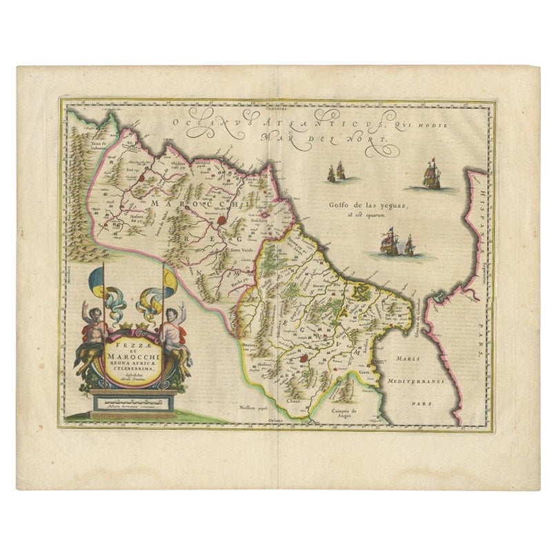
Antique Map of Morocco Showing Towns of Marakesh, Taradant and Fez, 1636
Located in Langweer, NL
Antique map titled 'Fezzae et Marocchi regna Africae Celeberrima'. Map of Morocco, showing large fortified towns of Marakesh, Taradante and Fez, towns, mountains, rivers, lakes, etc....
Category
Antique 17th Century Maps
Materials
Paper
$1,178 Sale Price
20% Off
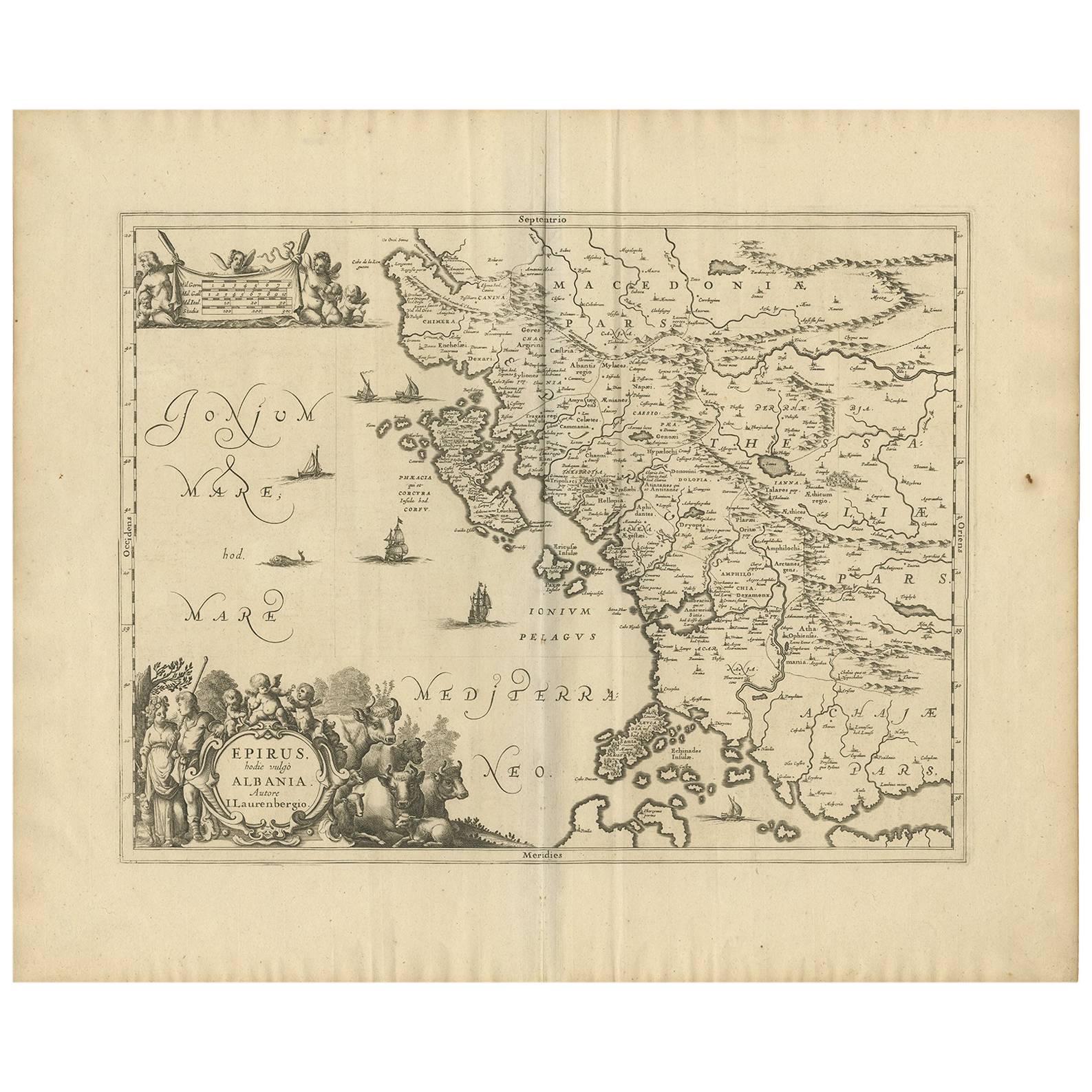
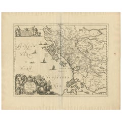
Antique Map of Epirus 'Albania, Greece' by J. Janssonius, circa 1650
Located in Langweer, NL
This map covers the northwestern coast of Greece and part of present-day Albania. The map was drawn by Johannes Wilhelm Laurenberg, a mathematician and historian who produced several...
Category
Antique Mid-17th Century Maps
Materials
Paper
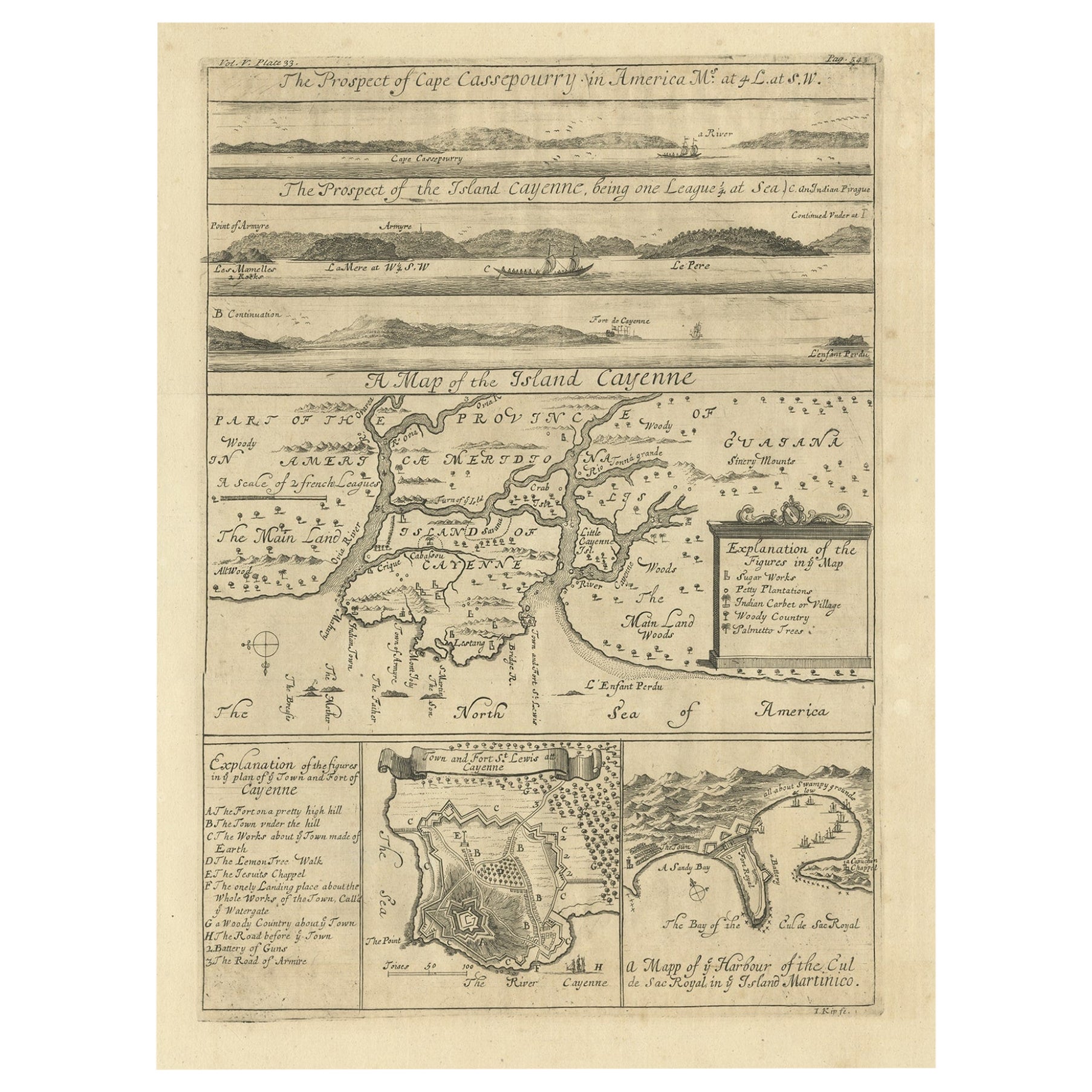
Antique Map of Cayenne and Cassepouri, French Guinea, South America, c.1730
Located in Langweer, NL
Antique map titled 'A Map of the Island Cayenne (..)’. A set of interesting copper engravings of Cayenne and Cassepouri, French Guinea, South America, and Martinique in the West Indies. The map of Cayenne, home of Cayenne pepper, has a key of symbols identifying the sugar works, petty plantations, indian carbet or village, woody country and palmetto trees. The plan of Fort Lewis, Cayenne also has a lettered key including; A. the fort on a pretty high hill...
Category
Antique 18th Century Maps
Materials
Paper
$358 Sale Price
20% Off
You May Also Like
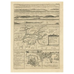
1646 Jansson Map Entitled "Procinvia Connactiae, " Ric.a006
Located in Norton, MA
1646 Jansson map entitled
"Procinvia connactiae,"
Ric.a006
Description: The PROVINCE of CONNAVGT 490 x 380From vol 4 of Jansson's Atlas Novus 1646, published in Amsterdam with...
Category
Antique 17th Century Unknown Maps
Materials
Paper

Map of the Kingdom of Sardinia and Part of the Kingdom of Genoa, Rome
By Giovanni Maria Cassini
Located in Hamilton, Ontario
18th century map by Italian engraver Giovanni Maria Cassini (Italy 1745-1824). Map of Part of the Kingdom of Sardinia and Part of the Kingdom of Genoa: Rome. This is a hand colored a...
Category
Antique 18th Century Italian Maps
Materials
Paper

$795 Sale Price
36% Off
1597 German Map of Alexandria by Georg Braun and Frans Hogenberg
By Georg Braun and Frans Hogenberg
Located in Chapel Hill, NC
1597 Map of Alexandria by Georg Braun and Frans Hogenberg, Germany. From "Civitas Orbis Terrarum", part 2, published in Cologne by Bertram Buchholz. Printed in 2 parts. Title: "Alexa...
Category
Antique 16th Century German Renaissance Maps
Materials
Paper

18th Century Map Engraving - Plan of the Works of the City of Messina, Sicily
Located in Corsham, GB
A map of Messina, a harbour city in northeast Sicily. Inscribed with the title in plate to the lower edge, 'Plan of the Works of the City of Messina, one of the strongest and most co...
Category
18th Century More Prints
Materials
Engraving

$285 Sale Price
20% Off
Antique Map - Gallia - Etching by Johannes Janssonius - 1650s
By Johannes Janssonius
Located in Roma, IT
Antique Map - Gallia is an antique map realized in 1650 by Johannes Janssonius (1588-1664).
The Map is Hand-colored etching, with coeval watercoloring.
Good conditions with slight ...
Category
1650s Modern Figurative Prints
Materials
Etching

17th Century Topographical Map of Cote D'azur, Avignon, Frejus by Iohan Peeters
Located in New York, NY
Fine topographical 17th century map by Iohan Peeters of the towns of Avignon and Frejus in the Cote d'Azur-Provence-Alpes Region of Southeastern France.
Beautifully suited decorativ...
Category
Antique 17th Century Dutch Maps
Materials
Paper

More Ways To Browse
Persian Maps
Antique Map Of The Philippines
Large Map Of Italy
Used Marine Compass
West Indies Colonial
Antique Pamphlets
Sicily Map
Thailand Map
Antique Maps Of Russian Empire
Antique Navigational Tools
Australian Colonial
Antique German Compass
Key Trade Sign
Spanish Galleon
World Map Of Trade Routes
Antique Puerto Rico
Albanian Antique
Antique Furniture Wiltshire