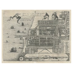
Items Similar to Original Antique Plan of the Dutch Settlement at Chinsura-Hooghly, India, 1746
Want more images or videos?
Request additional images or videos from the seller
1 of 5
Original Antique Plan of the Dutch Settlement at Chinsura-Hooghly, India, 1746
$335.77
$419.7120% Off
£249.78
£312.2220% Off
€280
€35020% Off
CA$459.78
CA$574.7320% Off
A$511.22
A$639.0220% Off
CHF 266.93
CHF 333.6620% Off
MX$6,222.76
MX$7,778.4520% Off
NOK 3,405.90
NOK 4,257.3820% Off
SEK 3,191.17
SEK 3,988.9620% Off
DKK 2,131.49
DKK 2,664.3620% Off
Shipping
Retrieving quote...The 1stDibs Promise:
Authenticity Guarantee,
Money-Back Guarantee,
24-Hour Cancellation
About the Item
Antique print, titled: 'Plan de la Loge Hollandoise d'Ougly'.
A plan of the Dutch settlement at Chinsura-Hooghly, India. This print originates from Prevost's 'Histoire Generale des Voyages' (Paris 1746-1759).
Artists and Engravers: Jakob van der Schley (Amsterdam 1715-1779) was a Dutch draughtsman and engraver. He studied under Bernard Picart and became heavily influenced by his style.
- Dimensions:Height: 9.97 in (25.3 cm)Width: 13.94 in (35.4 cm)Depth: 0 in (0.02 mm)
- Materials and Techniques:
- Period:1740-1749
- Date of Manufacture:1746
- Condition:Wear consistent with age and use. Condition: Very good, given age. Vertical folds, as issued. Some soiling of the margins. General age-related toning and/or occasional minor defects from handling. Blank verso. Please study image carefully.
- Seller Location:Langweer, NL
- Reference Number:Seller: PCT-49868 1stDibs: LU3054326969972
About the Seller
5.0
Recognized Seller
These prestigious sellers are industry leaders and represent the highest echelon for item quality and design.
Platinum Seller
Premium sellers with a 4.7+ rating and 24-hour response times
Established in 2009
1stDibs seller since 2017
2,510 sales on 1stDibs
Typical response time: <1 hour
- ShippingRetrieving quote...Shipping from: Langweer, Netherlands
- Return Policy
Authenticity Guarantee
In the unlikely event there’s an issue with an item’s authenticity, contact us within 1 year for a full refund. DetailsMoney-Back Guarantee
If your item is not as described, is damaged in transit, or does not arrive, contact us within 7 days for a full refund. Details24-Hour Cancellation
You have a 24-hour grace period in which to reconsider your purchase, with no questions asked.Vetted Professional Sellers
Our world-class sellers must adhere to strict standards for service and quality, maintaining the integrity of our listings.Price-Match Guarantee
If you find that a seller listed the same item for a lower price elsewhere, we’ll match it.Trusted Global Delivery
Our best-in-class carrier network provides specialized shipping options worldwide, including custom delivery.More From This Seller
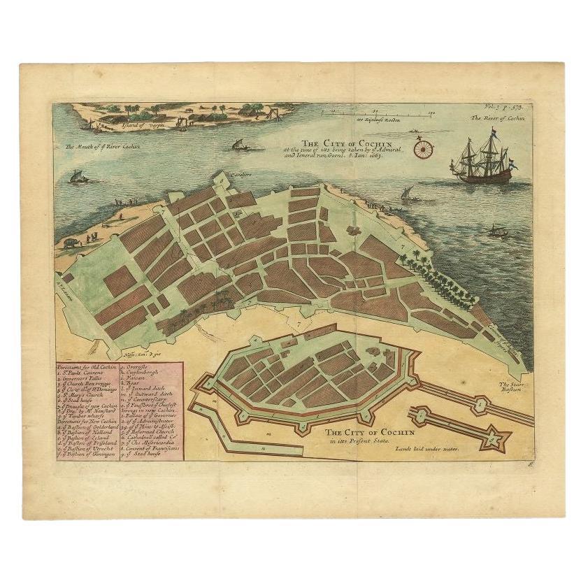
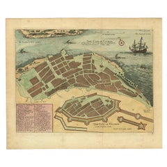
View AllVery Attractive Handcolored Antique Plan of Cochin in India, 1744
By Philip Baldaeus
Located in Langweer, NL
Antique map titled 'The City of Cochin (..).' Plan of Cochin, Malabar Coast, India, during the attack by Admiral van Goens in 1663. This map was published in 'The True and Exact Desc...
Category
Antique 18th Century Maps
Materials
Paper
$805 Sale Price
20% Off
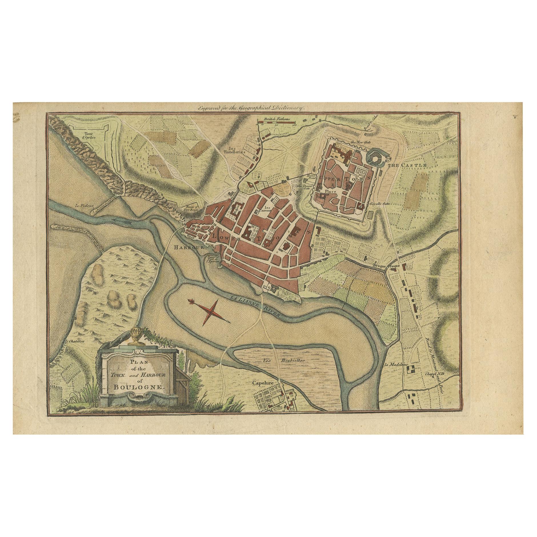
Antique Plan of the Town and Harbour of Boulogne-sur-Mer by Barrow 'c.1760'
Located in Langweer, NL
Antique map titled 'Plan of the Town and Harbour of Boulogne'. Original antique plan of the town and harbour of Boulogne-sur-Mer, France. This map originates from John Barrow...
Category
Antique Mid-18th Century Maps
Materials
Paper
$143 Sale Price
20% Off
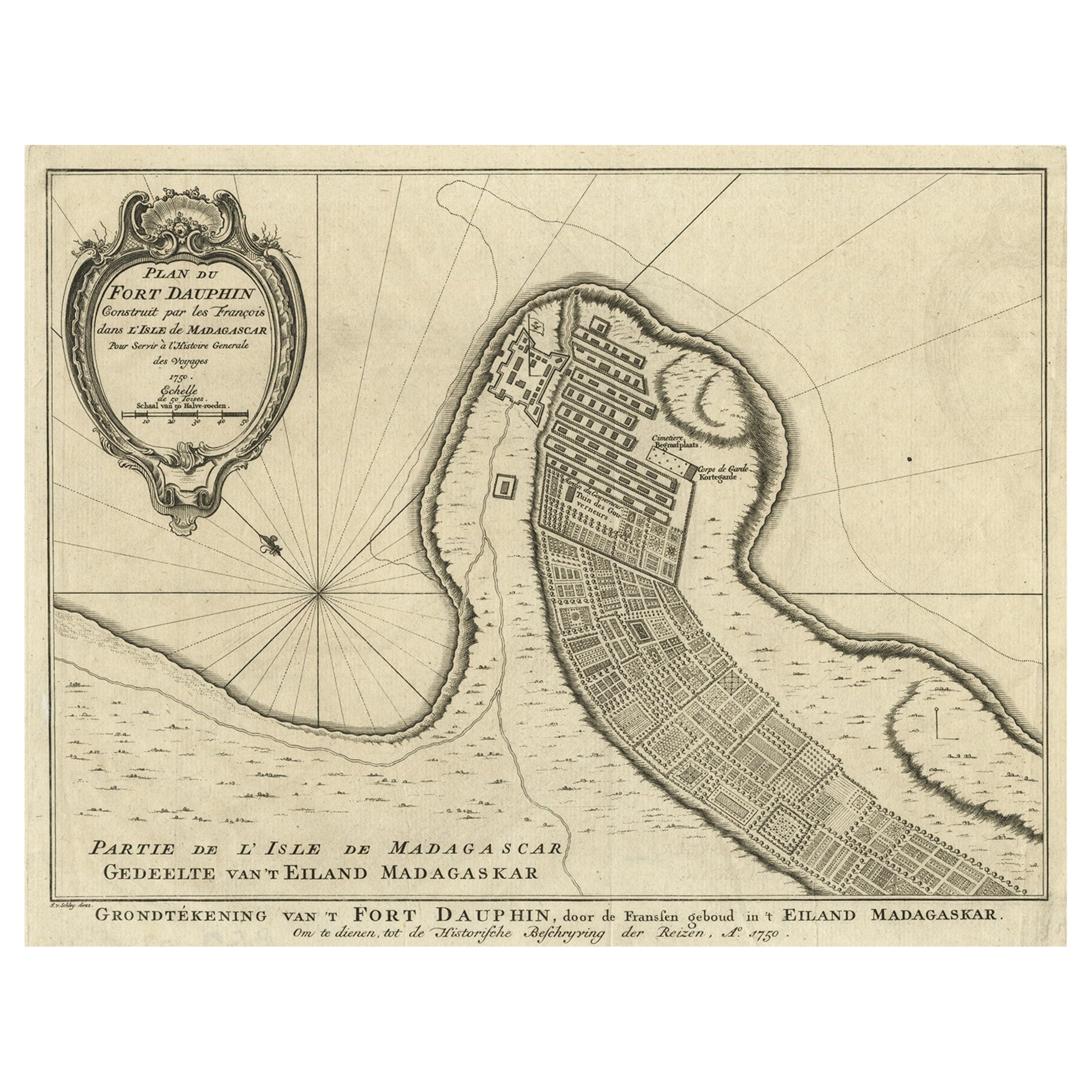
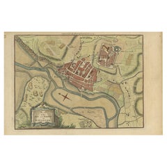
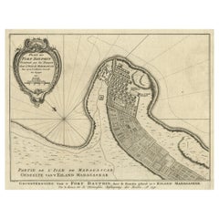
Antique Plan of Fort Dauphin on Madagascar of the East Coast of Africa, 1756
Located in Langweer, NL
Antique map titled 'Plan du Fort Dauphin (..) -
Grondtekening van 't Fort Dauphin'. Plan of Fort Dauphin on the island of Madagascar of the east coast of Africa. This print origi...
Category
Antique 1750s Maps
Materials
Paper
$230 Sale Price
20% Off
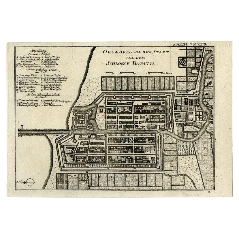
Antique Plan of Batavia and the Castle in the Dutch East Indies, 1763
Located in Langweer, NL
Antique map titled 'Grundriss von der Stadt und dem Schlosse Batavia.' Plan of the city and the castle of Batavia in the Dutch East Indies / Indonesia. From 'Algemeine Welthistorie (...
Category
Antique 18th Century Maps
Materials
Paper

$374 Sale Price
20% Off
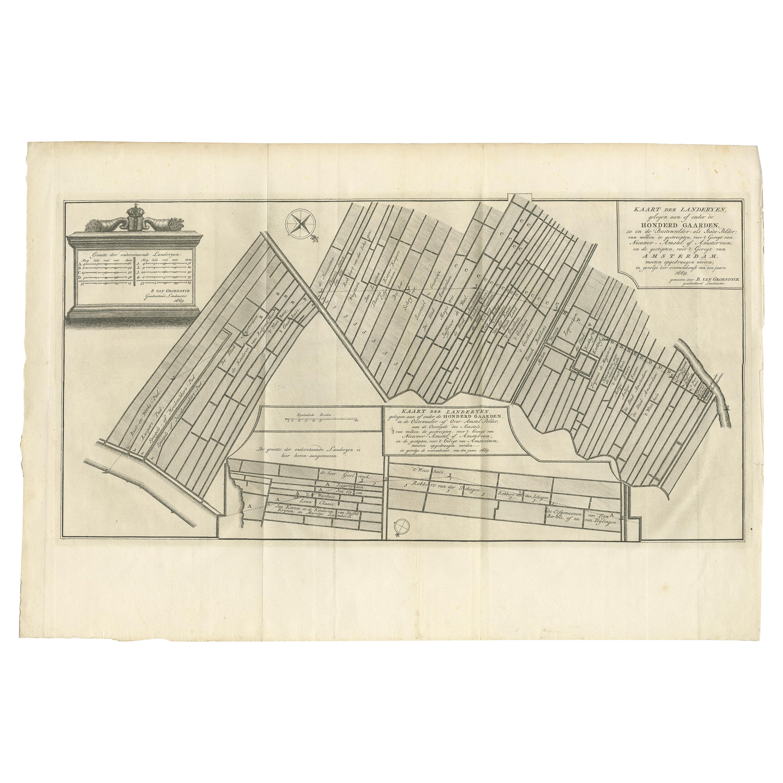
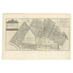
Antique Map Showing Estates of 1669 in Amsterdam, Published in c.1767
Located in Langweer, NL
Antique map titled 'Kaart der landeryen, gelegen aan of onder de honderd gaarden, zo in de Buitenvelder- als Stads-polder; van welken de gestreepten, voor 't geregt van Nieuwer-Amste...
Category
Antique 18th Century Maps
Materials
Paper
$239 Sale Price
20% Off
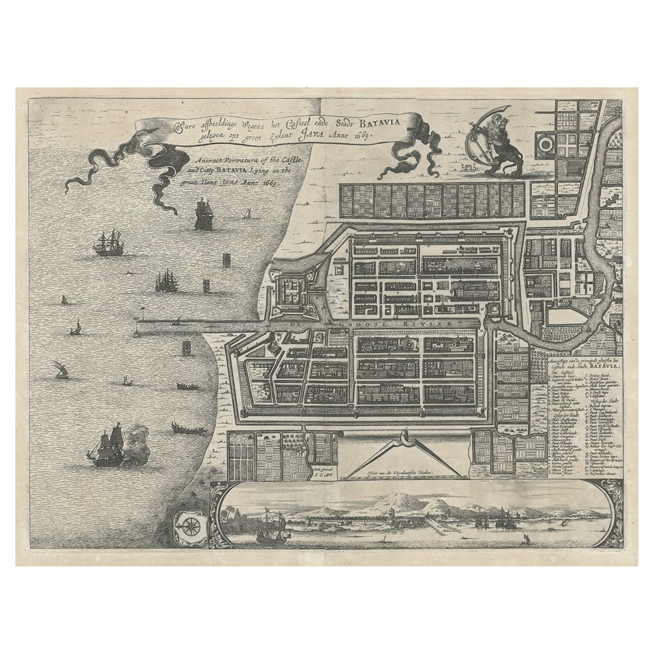
Antique Plan of the Castle & City of Batavia 'Jakarta' on Java, Indonesia, c1669
Located in Langweer, NL
Antique map Batavia titled 'Ware Affbeeldinge wegens het Casteel ende Stadt Batavia'.
Antique print of the castle and city of Batavia on the Island of Java'. Rare edition with En...
Category
Antique 1660s Maps
Materials
Paper
$1,199 Sale Price
20% Off
You May Also Like
18th Century Map Engraving - Newport, a Strong Sea-Port Town in Flanders
Located in Corsham, GB
A map of Nieuwpoort, anglicised to 'Newport', in northern Belgium. There is a panorama in the upper quarter depicting major landmarks. Below is a plan of the town, including its strong defences and ships at the port in the lower register. Inscribed with the title in plate to the lower edge, 'Newport a Strong Sea-Port Town...
Category
18th Century More Prints
Materials
Engraving

$269 Sale Price
20% Off
Original Antique Map or City Plan of Geneva, Switzerland. Circa 1835
Located in St Annes, Lancashire
Nice map of Geneva
Drawn and engraved by J.Dower
Published by Orr & Smith. C.1835
Unframed.
Free shipping
Category
Antique 1830s English Maps
Materials
Paper

Antique Town Plan Map, Poole, English, Framed Cartography, Georgian, Circa 1780
Located in Hele, Devon, GB
This is an antique town plan map of Poole in Dorset. An English, framed atlas engraving, dating to the 18th century and later.
Fascinating cartography with annotated streets and pl...
Category
Antique Late 18th Century British George III Maps
Materials
Glass, Wood, Paper

Original Antique Map or City Plan of Amsterdam, Netherlands. Circa 1835
Located in St Annes, Lancashire
Nice map of Amsterdam
Drawn and engraved by J.Dower
Published by Orr & Smith. C.1835
Unframed.
Free shipping
Category
Antique 1830s English Maps
Materials
Paper

Antique French Map of Asia Including China Indoneseia India, 1783
Located in Amsterdam, Noord Holland
Very nice map of Asia. 1783 Dedie au Roy.
Additional information:
Country of Manufacturing: Europe
Period: 18th century Qing (1661 - 1912)
Condition: Overall Condition B (Good Used)...
Category
Antique 18th Century European Maps
Materials
Paper

$648 Sale Price
20% Off
19th Century Lithograph Map of Lower Manhattan, New York
Located in Haddonfield, NJ
1859 hand colored map of Lower Manhattan or New Amsterdam by George H. Moore.
Category
Antique 19th Century English Folk Art Maps
Materials
Paper

$620 Sale Price
20% Off
More Ways To Browse
Ottoman Map
Antique Map Of Korea
Maps South East Asia
Antique Furniture Kansas City
Antique Great Lakes Map
Arnold And Son
Indianapolis Antique Furniture
Antique Map Of Jerusalem
Antique Maps Of Sicily
Antique Celestial Maps
Antique Compass Maritime Compasses
Bengal Map
J C Walker Map
Map Of Ancient Greece
Ptolemy Map
Antique Marine Compass
Map Of Jerusalem
1820 World Map