Items Similar to Original Copper Engraving of the Northeast Coast of Australia, 1803
Want more images or videos?
Request additional images or videos from the seller
1 of 6
Original Copper Engraving of the Northeast Coast of Australia, 1803
$853.82
$1,067.2720% Off
£635.15
£793.9420% Off
€712
€89020% Off
CA$1,169.17
CA$1,461.4620% Off
A$1,299.95
A$1,624.9420% Off
CHF 678.76
CHF 848.4520% Off
MX$15,823.59
MX$19,779.4920% Off
NOK 8,660.73
NOK 10,825.9120% Off
SEK 8,114.69
SEK 10,143.3620% Off
DKK 5,420.06
DKK 6,775.0820% Off
Shipping
Retrieving quote...The 1stDibs Promise:
Authenticity Guarantee,
Money-Back Guarantee,
24-Hour Cancellation
About the Item
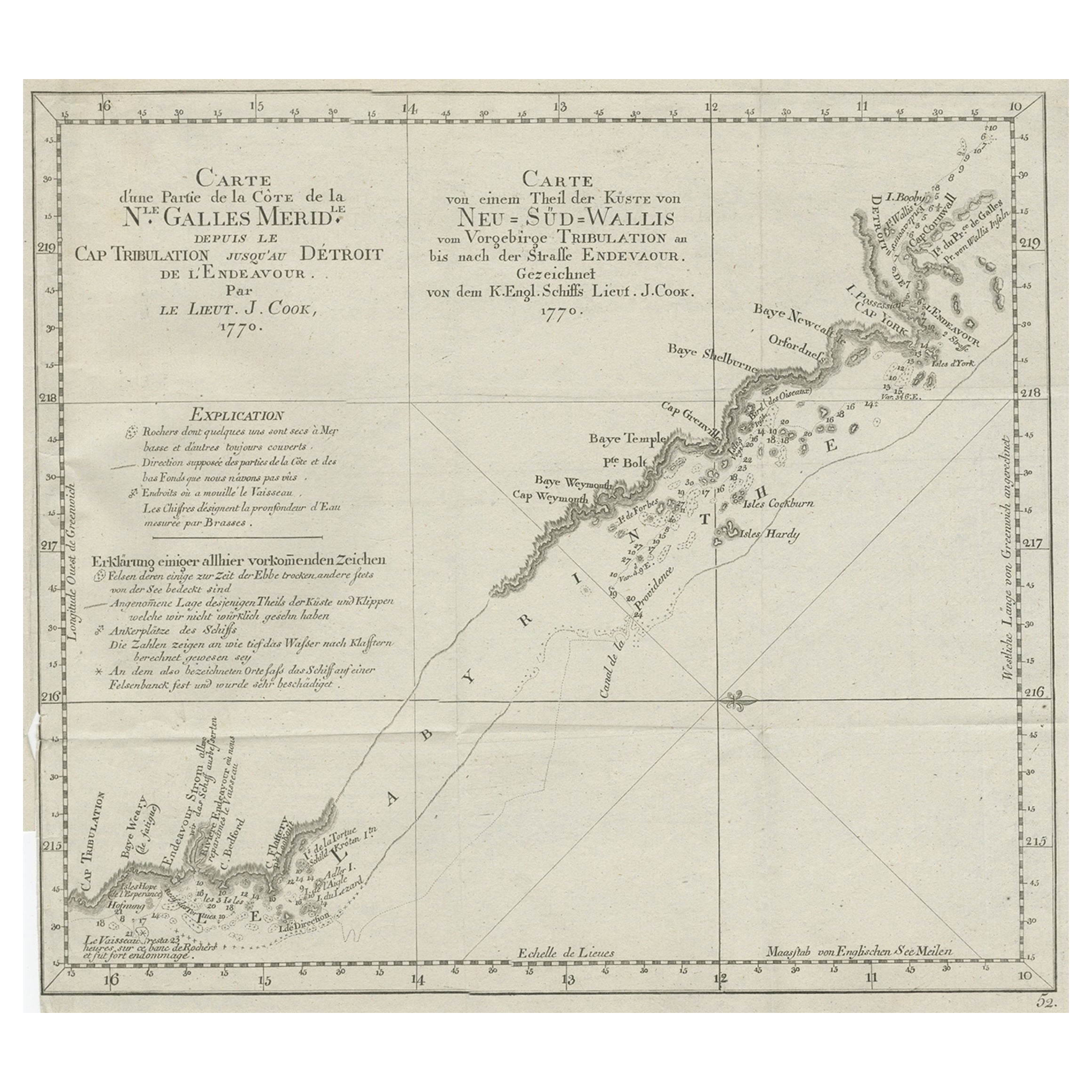
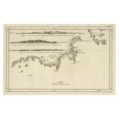
Antique map Australia titled 'Kaart van een gedeelte van de Kust van Nieuw Zuid Wales van Kwelling Kaap tot de Endeavour-Straat door Luit. J. Cook'.
A chart of the northeast coast of Australia from the northern extremity of Cape York peninsula with Endeavour Strait to the Endeavour River and present day Cooktown. Originates from 'Reizen Rondom de Waereld door James Cook (..)'.
Artists and Engravers: Translated by J.D. Pasteur. Published by Honkoop, Allart en Van Cleef.
Condition:
Very good, general age-related toning. Please study image carefully.
About the Seller
5.0
Recognized Seller
These prestigious sellers are industry leaders and represent the highest echelon for item quality and design.
Platinum Seller
Premium sellers with a 4.7+ rating and 24-hour response times
Established in 2009
1stDibs seller since 2017
2,511 sales on 1stDibs
Typical response time: <1 hour
- ShippingRetrieving quote...Shipping from: Langweer, Netherlands
- Return Policy
Authenticity Guarantee
In the unlikely event there’s an issue with an item’s authenticity, contact us within 1 year for a full refund. DetailsMoney-Back Guarantee
If your item is not as described, is damaged in transit, or does not arrive, contact us within 7 days for a full refund. Details24-Hour Cancellation
You have a 24-hour grace period in which to reconsider your purchase, with no questions asked.Vetted Professional Sellers
Our world-class sellers must adhere to strict standards for service and quality, maintaining the integrity of our listings.Price-Match Guarantee
If you find that a seller listed the same item for a lower price elsewhere, we’ll match it.Trusted Global Delivery
Our best-in-class carrier network provides specialized shipping options worldwide, including custom delivery.More From This Seller
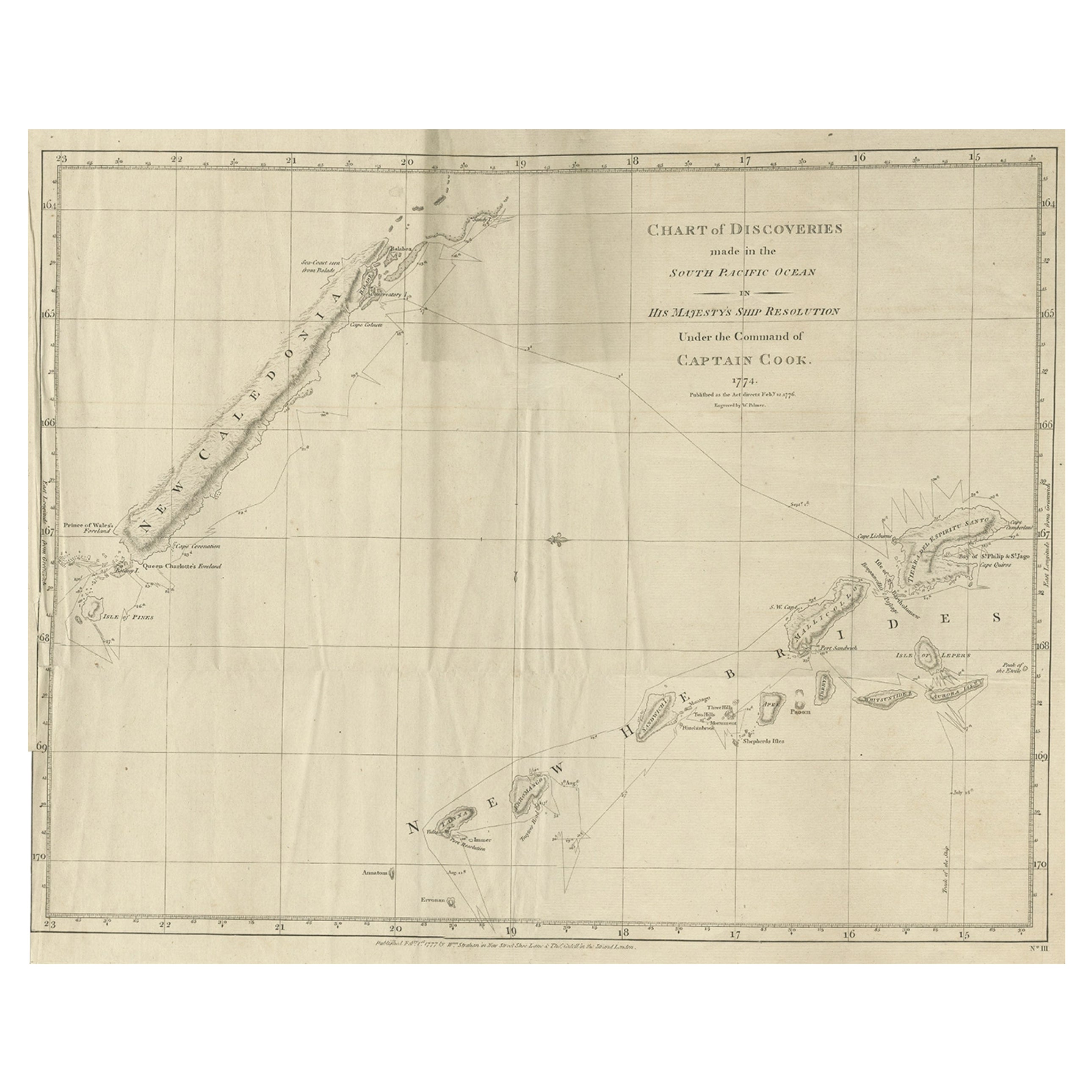
View AllRare Engraving of New Caledonia & New Hebrides from Capt. Cook's Travels, 1777
Located in Langweer, NL
Antique map titled 'Chart of Discoveries made in the South Pacific Ocean'.
Rare engraving from the official British Admiralty sanctioned edition of the accounts of Cook’s second voyage. All other later copies made of this image by other publishers were unauthorised, usually smaller and inferior in quality. Made after Cook's discovery of the island group on 4 September 1774, which he named New Caledonia...
Category
Antique 1770s Maps
Materials
Paper
$719 Sale Price
20% Off
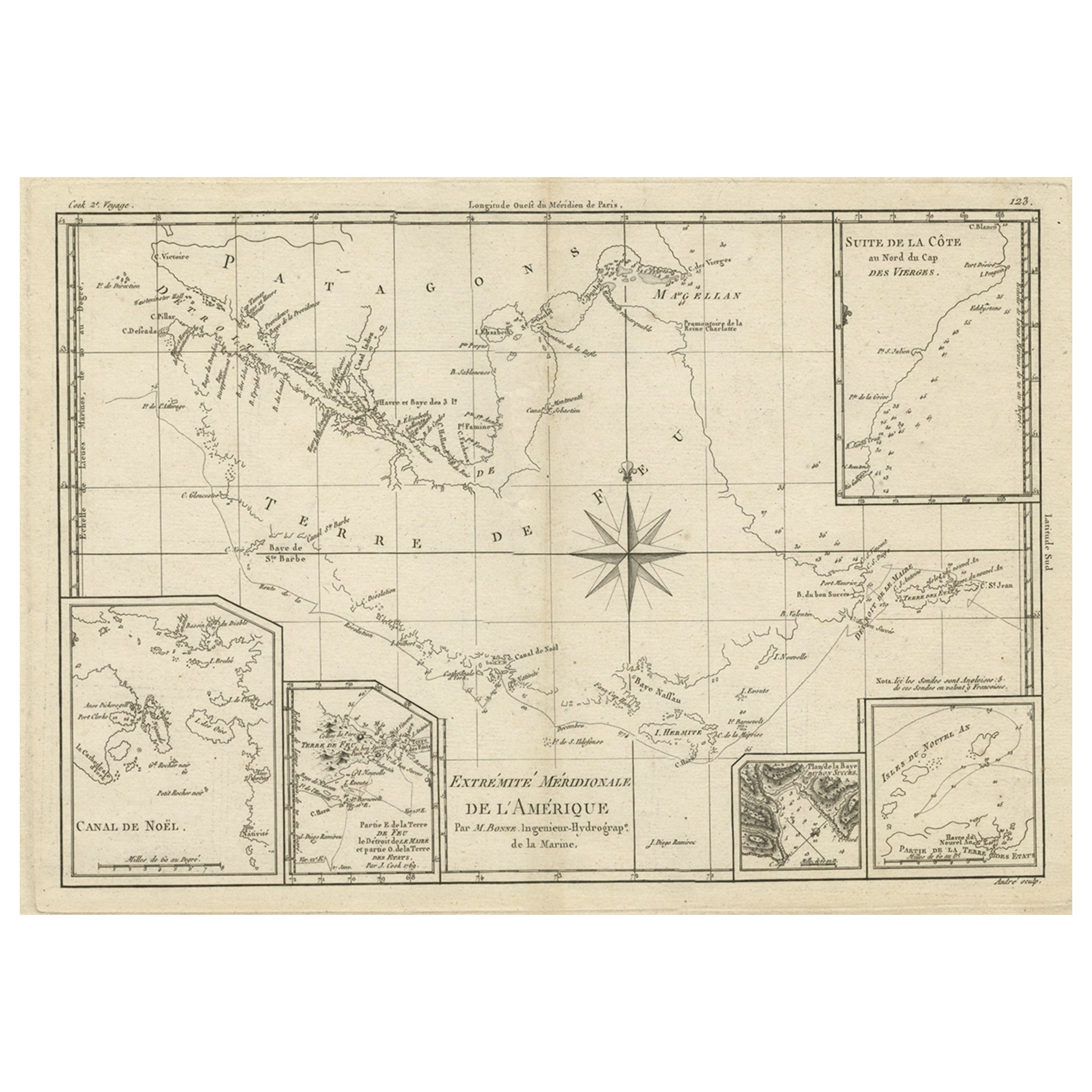
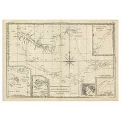
Copper Engraved Map of Tierra del Fuego and the Strait of Magellan, c1780
Located in Langweer, NL
Antique map titled 'Extremite Meridionale de l'Amerique.'
Copper engraved map of Tierra del Fuego and the Strait of Magellan with five detailed insets of the region showing soundings, anchorages, etc. Engraved by Andre. This map originates from 'Atlas de Toutes les Parties Connues du Globe Terrestre'.
Artists and Engravers: Rigobert Bonne (1727-1795 ) was one of the most important cartographers of the late 18th century. In 1773 he succeeded Jacques Bellin as Royal Cartographer to France in the office of the Hydrographer at the Depôt de la Marine. Working in his official capacity Bonne compiled some of the most detailed and accurate maps of the period. Bonne's work represents an important step in the evolution of the cartographic ideology away from the decorative work of the 17th and early 18th century towards a more detail oriented and practical aesthetic. With regard to the rendering of terrain Bonne maps...
Category
Antique 1780s Maps
Materials
Paper
$345 Sale Price
20% Off
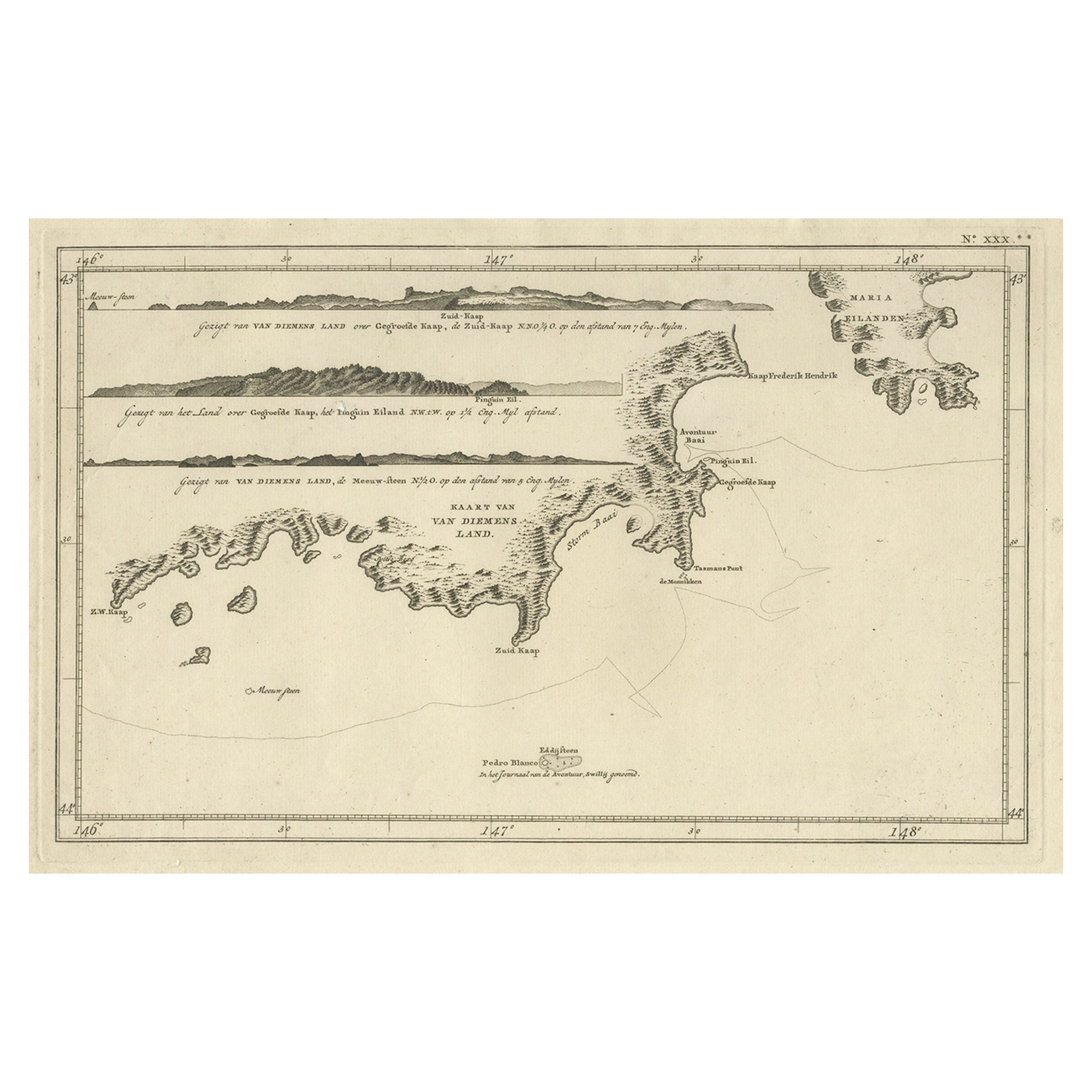
Antique Coastal Views and a Map of Van Diemens Land (Tasmania), Australia, 1803
Located in Langweer, NL
Antique map Tasmania titled 'Kaart van Diemens Land'.
Coastal views and a map of van Diemens Land (Tasmania). Originates from 'Reizen Rondom de Waereld ...
Category
Antique Early 1800s Maps
Materials
Paper
$825 Sale Price
20% Off
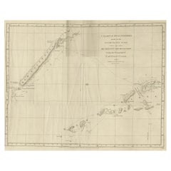
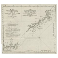
Old Chart of the North-Eastern Coast of Australia Discovered by Cook, 1774
Located in Langweer, NL
Antique print titled Carte d'une Partie de la Cote de la N.le Galles Merid etc.
An interesting chart of the north-eastern coast of Australia discovered by Cook in 1770, showing th...
Category
Antique 1770s Maps
Materials
Paper
$729 Sale Price
20% Off
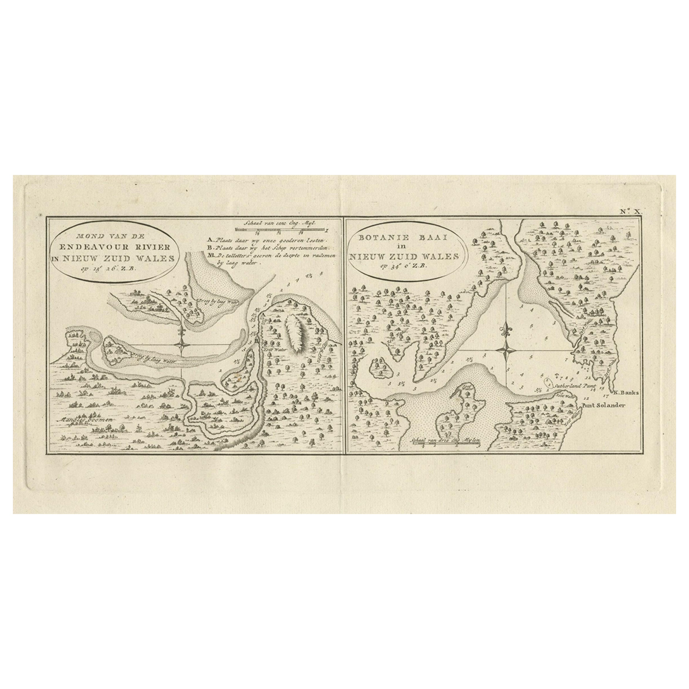
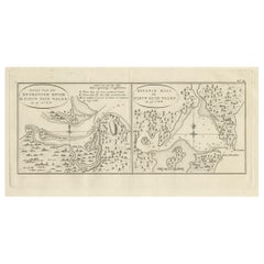
Antique Map of Endeavour River and Botany Bay, New South Wales, Australia, 1803
Located in Langweer, NL
Antique map Australia titled 'Mond van de Endeavour Rivier in Nieuw Zuid Wales' and 'Botanie Baai in Nieuw Zuid Wales'. Antique map of the Endeav...
Category
Antique 19th Century Maps
Materials
Paper
$767 Sale Price
20% Off
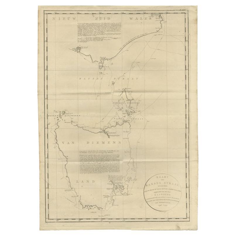
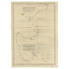
Large Antique Map of Bass Strait, Tasmania, Australia by Cook, 1803
Located in Langweer, NL
Antique map Australia titled 'Kaart van Basses Straat tusschen Nieuw Zuid Wales en van Diemensland (..)'. Large chart of Bass Strait and one of t...
Category
Antique 19th Century Maps
Materials
Paper
$4,317 Sale Price
20% Off
You May Also Like
Original Antique Map of Australia by Dower, circa 1835
Located in St Annes, Lancashire
Nice map of Australia
Drawn and engraved by J.Dower
Published by Orr & Smith. C.1835
Unframed.
Free shipping
Category
Antique 1830s English Maps
Materials
Paper

Original Antique Map of Tasmania, Australia by Dower, circa 1835
Located in St Annes, Lancashire
Nice map of Tasmania
Drawn and engraved by J.Dower
Published by Orr & Smith. C.1835
Unframed.
Free shipping
Category
Antique 1830s English Maps
Materials
Paper

Ancient Map of Oceania - Original Etching - 19th century
Located in Roma, IT
This Map of Oceania is an etching realized in the 19th century.
The state of preservation of the artwork is good. At the top of the paper, the inscription “Longitudine del Meridiano...
Category
19th Century More Prints
Materials
Etching

Original Antique Map of South Africa, Arrowsmith, 1820
Located in St Annes, Lancashire
Great map of South Africa.
Drawn under the direction of Arrowsmith.
Copper-plate engraving.
Published by Longman, Hurst, Rees, Orme and Br...
Category
Antique 1820s English Maps
Materials
Paper

New South Wales, Australia, antique mid 19th century engraved John Tallis map
Located in Melbourne, Victoria
'New South Wales'
With decorative border surrounds and vignettes of 'Sydney Cove'. 'The Murray' and 'Xanthorrhea'.
'Drawn and engraved by J Rapkin'. Published by John Tallis.
375m...
Category
1840s Victorian Landscape Prints
Materials
Engraving

Large Original Antique Map of Australia by Sidney Hall, 1847
Located in St Annes, Lancashire
Great map of Australia
Drawn and engraved by Sidney Hall
Steel engraving
Original colour outline
Published by A & C Black. 1847
Unframed
Free shipping.
Category
Antique 1840s Scottish Maps
Materials
Paper

More Ways To Browse
Antique Copper Engravings
Australian Antique Furniture
Antique Copper Australia
Antique Navigational Tools
Antique German Compass
Key Trade Sign
Spanish Galleon
World Map Of Trade Routes
Antique Puerto Rico
Albanian Antique
Antique Furniture Wiltshire
Antique Maps Of Israel
Framed Africa Maps
Antique Furniture Goa
Croatian Antiques
Map Of Israel
Teak Sphere
18th Century Scottish Collectibles