Items Similar to Print of Maps of Islands of the South Pacific, Incl. Pitcairn & Dusky Bay, 1788


Want more images or videos?
Request additional images or videos from the seller
1 of 5
Print of Maps of Islands of the South Pacific, Incl. Pitcairn & Dusky Bay, 1788
$420.87
$526.0820% Off
£311.22
£389.0320% Off
€352
€44020% Off
CA$582.42
CA$728.0220% Off
A$648.48
A$810.6120% Off
CHF 337.46
CHF 421.8220% Off
MX$7,827.09
MX$9,783.8620% Off
NOK 4,232.04
NOK 5,290.0620% Off
SEK 3,997.43
SEK 4,996.7920% Off
DKK 2,680.50
DKK 3,350.6220% Off
About the Item
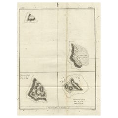
Antique map titled 'Esquisse de la Bay Dusky, Dans La Nouvelle Zeelande / I. Pitcairn / Isles de Wallis / I Turtle / I des Cocos and Traitres / Palmerston I. / I. Suavage / I. D'Hervey/ Havre Pickersgill / I de Pasques.'
Detailed set of maps of the islands of the South Pacific, with a large compass rose and inset of Dusky Bay on New Zealand. This map originates from 'Atlas encyclopedique: contenant la géographie ancienne' by Rigobert Bonne.
Artists and Engravers: Rigobert Bonne (1727-1795 ) was one of the most important cartographers of the late 18th century. In 1773 he succeeded Jacques Bellin as Royal Cartographer to France in the office of the Hydrographer at the Depôt de la Marine. Working in his official capacity Bonne compiled some of the most detailed and accurate maps of the period. Bonne's work represents an important step in the evolution of the cartographic ideology away from the decorative work of the 17th and early 18th century towards a more detail oriented and practical aesthetic. With regard to the rendering of terrain Bonne maps bear many stylistic similarities to those of his predecessor, Bellin. However, Bonne maps generally abandon such common 18th century decorative features such as hand coloring, elaborate decorative cartouches, and compass roses. While mostly focusing on coastal regions, the work of Bonne is highly regarded for its detail, historical importance, and overall aesthetic appeal.
Condition: Good, given age. Irregular edges as issued with an occasinal small tear. A few spots in the margins. Original middle fold as issued. General age-related toning and/or occasional minor defects from handling. Please study image carefully.
- Dimensions:Height: 12.21 in (31 cm)Width: 18.31 in (46.5 cm)Depth: 0 in (0.02 mm)
- Materials and Techniques:
- Period:1780-1789
- Date of Manufacture:1788
- Condition:Condition: Good, given age. Irregular edges as issued with an occasinal small tear. A few spots in the margins. Original middle fold as issued. General age-related toning and/or occasional minor defects from handling. Please study image carefully.
- Seller Location:Langweer, NL
- Reference Number:Seller: PCT-578931stDibs: LU3054326755262
About the Seller
5.0
Recognized Seller
These prestigious sellers are industry leaders and represent the highest echelon for item quality and design.
Platinum Seller
Premium sellers with a 4.7+ rating and 24-hour response times
Established in 2009
1stDibs seller since 2017
2,587 sales on 1stDibs
Typical response time: <1 hour
- ShippingRetrieving quote...Shipping from: Langweer, Netherlands
- Return Policy
Authenticity Guarantee
In the unlikely event there’s an issue with an item’s authenticity, contact us within 1 year for a full refund. DetailsMoney-Back Guarantee
If your item is not as described, is damaged in transit, or does not arrive, contact us within 7 days for a full refund. Details24-Hour Cancellation
You have a 24-hour grace period in which to reconsider your purchase, with no questions asked.Vetted Professional Sellers
Our world-class sellers must adhere to strict standards for service and quality, maintaining the integrity of our listings.Price-Match Guarantee
If you find that a seller listed the same item for a lower price elsewhere, we’ll match it.Trusted Global Delivery
Our best-in-class carrier network provides specialized shipping options worldwide, including custom delivery.More From This Seller
View AllAntique Map of Islands in the Mediterranean by Bowen, 'c.1760'
Located in Langweer, NL
Antique map titled 'Particular Draughts of some of the chief African Islands (..)'. Eight small maps on one sheet including 'Islands of Malta Goze & Cuming, An Accurate Chart of Cape de Verde Islands…, Island of St Helena.., Island of Madera, Island of Teneriffe, The Bay of Agoa…, The Dutch Fort at the Cape of Good Hope…, A Draught of Table Bay...
Category
Antique Mid-18th Century Maps
Materials
Paper

$478 Sale Price
20% Off
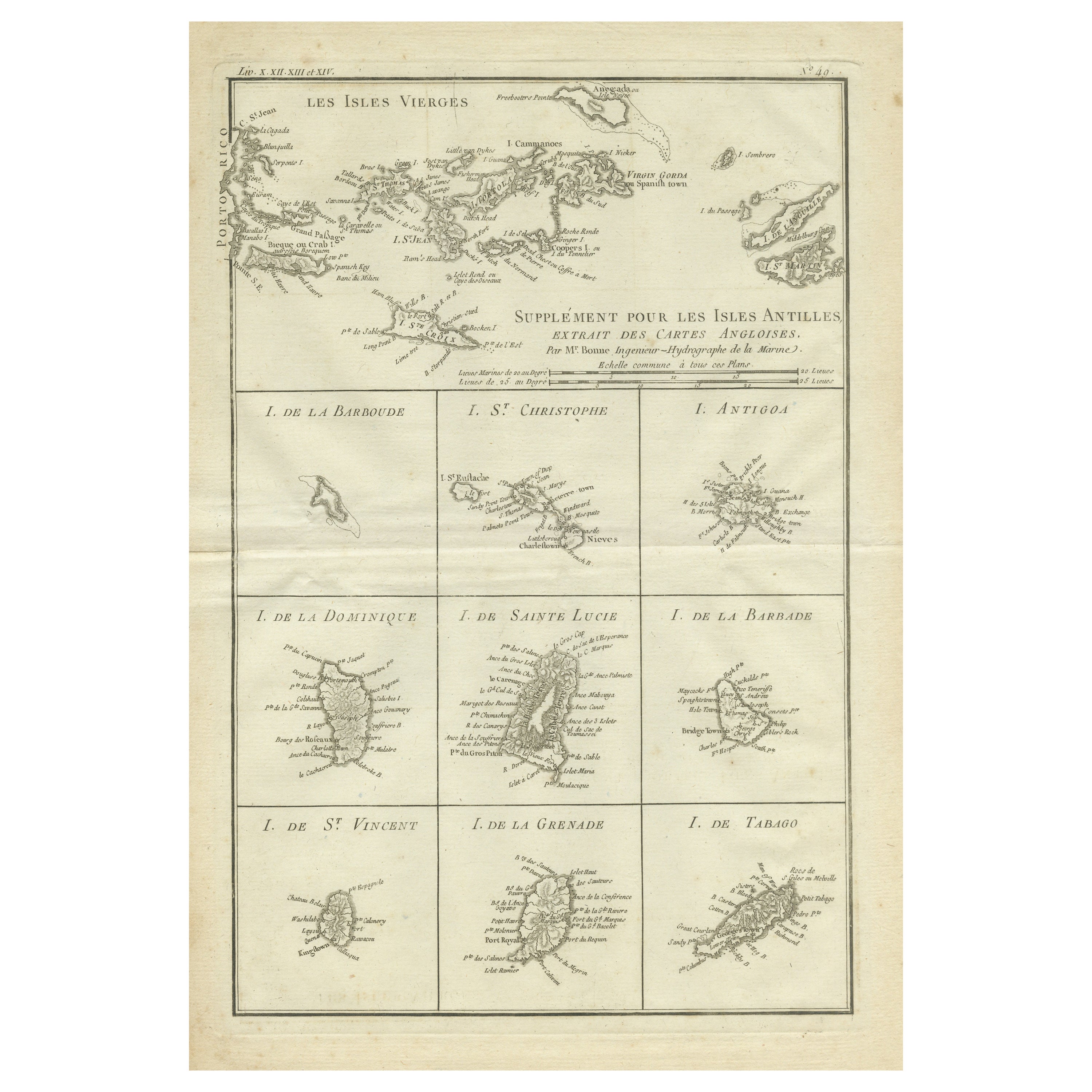
Original Antique Map of the Virgin Islands with Insets of Caribbean Isles, 1787
Located in Langweer, NL
Antique map titled 'Supplément pour les Isles Antilles (..)'. Original old map of the Virgin Islands, with insets of Barbuda, St. Kits, Antigua, Dominica, St. Lucia, Barbados, St. Vi...
Category
Antique Late 18th Century Maps
Materials
Paper
$248 Sale Price
20% Off
Free Shipping
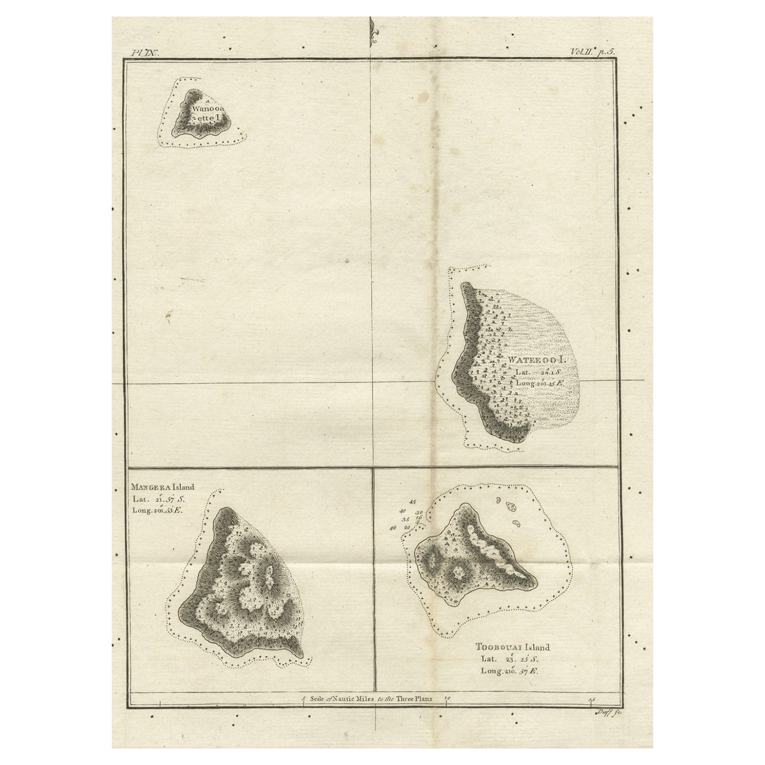
Old Map of the Cook Islands Takutea, Atiu, Mangaiac and Tubuai, Polynesia, 1781
Located in Langweer, NL
Antique map titled 'Mangeea Island, Toobouai Island (..)'. Map of three of the Cook Islands: Wanooaette [i.e. Takutea] Island, Wateeoo [i.e. Tui or Atiu] ...
Category
Antique 18th Century Maps
Materials
Paper
$124 Sale Price
20% Off
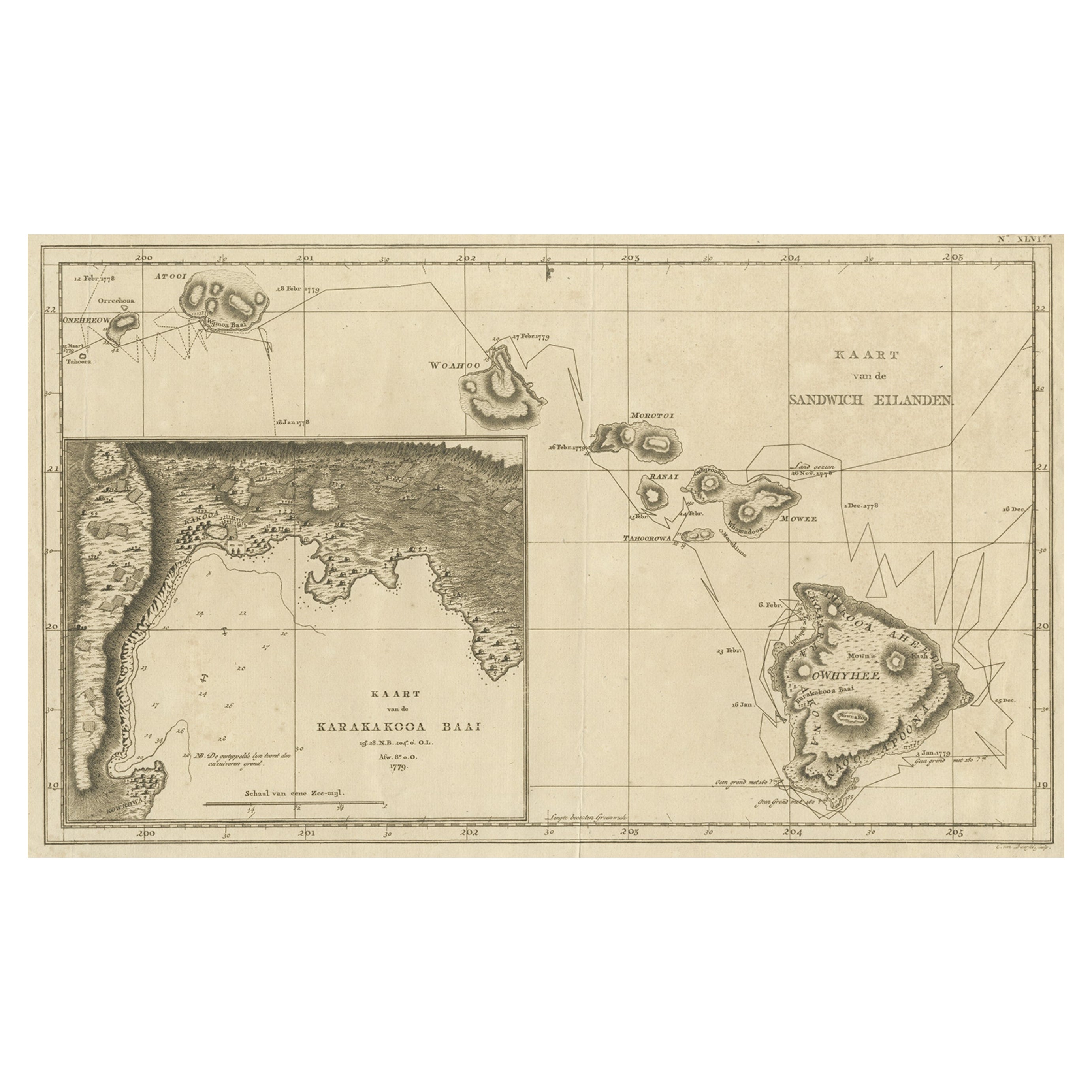
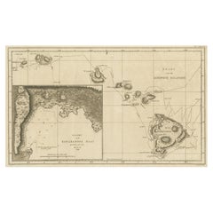
Map of the Hawaiian Islands with a Large Inset of Karakakooa Bay, 1803
Located in Langweer, NL
Antique map titled 'Kaart van de Sandwich Eilanden'.
Map of the Hawaiian Islands with a large inset of Karakakooa Bay, including soundings and anchorages. Originates from 'Reizen R...
Category
Antique Early 1800s Maps
Materials
Paper
$2,152 Sale Price
20% Off
Free Shipping
Antique Map of the Friendly Islands by Cook, 1803
Located in Langweer, NL
Antique map Friendly Islands titled 'Kaart van de Vrienden Eilanden'. Antique map of the Friendly Islands depicting Rotterdam or Anamocka, Middelburg or Eaoowe and Amsterdam or Tonga...
Category
Antique 19th Century Maps
Materials
Paper

$205 Sale Price
20% Off
Antique Map of Quinam and the Côn ?ao Islands by Sayer, 1778
Located in Langweer, NL
Antique map titled 'A Chart of a part of the Coast of Cochinchina' and 'Plan of Pulo Condor'. Two maps on one sheet. The upper map shows part of the coast of Cochinchina from Cham Co...
Category
Antique 18th Century Maps
Materials
Paper

$315 Sale Price
20% Off
You May Also Like
Original Antique Map of US Possessions In The Pacific Ocean, C.1900
Located in St Annes, Lancashire
Fabulous map of US possessions in the Pacific Ocean
Original color.
Engraved and printed by the George F. Cram Company, Indianapolis.
Published, C.1900.
Unframed.
Free shipping.
Category
Antique 1890s American Maps
Materials
Paper

Original Antique Map of South America. C.1780
Located in St Annes, Lancashire
Great map of South America
Copper-plate engraving
Published C.1780
Two small worm holes to left side of map
Unframed.
Category
Antique Early 1800s English Georgian Maps
Materials
Paper

Original Antique Map of Hawaii And Adjacent Islands. C.1900
Located in St Annes, Lancashire
Fabulous map of Hawaii. With a vignette of Honolulu
Original color.
Engraved and printed by the George F. Cram Company, Indianapolis.
Published, C.1900.
Unframed.
Free shipping.
Category
Antique 1890s American Maps
Materials
Paper

Original Antique Map of South East Asia by Thomas Clerk, 1817
Located in St Annes, Lancashire
Great map of South East Asia
Copper-plate engraving
Drawn and engraved by Thomas Clerk, Edinburgh.
Published by Mackenzie And Dent, 1817
Unframed.
Category
Antique 1810s English Maps
Materials
Paper

Original Antique Map of Switzerland, Engraved By Barlow, Dated 1807
Located in St Annes, Lancashire
Great map of Switzerland
Copper-plate engraving by Barlow
Published by Brightly & Kinnersly, Bungay, Suffolk.
Dated 1807
Unframed.
Category
Antique Early 1800s English Maps
Materials
Paper

Large Original Antique Map of The Canary Islands. 1894
Located in St Annes, Lancashire
Superb Antique map of The Canary Islands
Published Edward Stanford, Charing Cross, London 1894
Original colour
Good condition
Unframed.
Free shipping
Category
Antique 1890s English Maps
Materials
Paper

More Ways To Browse
Small Antique Compass
Antique Marine Compass
Thailand Map
Antique Maps Of Russian Empire
Antique Navigational Tools
Australian Colonial
Antique German Compass
Key Trade Sign
Spanish Galleon
World Map Of Trade Routes
Antique Puerto Rico
Albanian Antique
Antique Furniture Wiltshire
Antique Maps Of Israel
Framed Africa Maps
Antique Furniture Goa
Croatian Antiques
Map Of Israel