Items Similar to Rare Map of Kildin Island in Russia Plus Engraving of Seal Hunting, 1614

Want more images or videos?
Request additional images or videos from the seller
1 of 8
Rare Map of Kildin Island in Russia Plus Engraving of Seal Hunting, 1614
$718.64
$898.3020% Off
£532.55
£665.6920% Off
€600
€75020% Off
CA$981.09
CA$1,226.3620% Off
A$1,091.42
A$1,364.2720% Off
CHF 572.13
CHF 715.1720% Off
MX$13,336.85
MX$16,671.0720% Off
NOK 7,285.42
NOK 9,106.7820% Off
SEK 6,858.22
SEK 8,572.7720% Off
DKK 4,568.35
DKK 5,710.4320% Off
Shipping
Retrieving quote...The 1stDibs Promise:
Authenticity Guarantee,
Money-Back Guarantee,
24-Hour Cancellation
About the Item
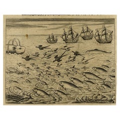
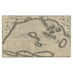
Insula Kilduyn. Orig. copper-engraving after details from J. H. van Linschoten's map taken from his account of the three expeditions undertaken by Willem Barents in 1594, in an attempt to discover a north-east passage to China. Kildin is a small Russian island in the Barents Sea. "Vera genuina indu' inscripted in the top.
The image on the verso show two small rowing boats with seal or whale hunters and the dangers that go with it.
From the Johan Isaac Pontanus & J. Hondius edition of 1614 - 'Historische beschrijvinghe der seer wijt beroemde coop-stadt Amsterdam'.
creator: Anoniem / Anonymous(engraver / etcher), Lodewijcksz, Willem(copied after)
period: 1614
material: paper
technique: engraving
measurements sheet of Kildin island: 9.5 x 7 inch ( 24x18 cm) - the engraving of the Seal Hunt is an inch bigger.
measurement map: 5.1 x 3.5 inch ( 13x9 cm ) - - the engraving of the Whale Hunt is an inch bigger.
The condition of the engravings itself is very good, Dutch text accompanying the engravings. The area around the engravings has (water) damage, brown spots and borders of the leaf are scuffy. Study the image of the larger leaf carefully.
- Dimensions:Height: 7.09 in (18 cm)Width: 9.45 in (24 cm)Depth: 0 in (0.02 mm)
- Materials and Techniques:
- Period:Early 17th Century
- Date of Manufacture:1614
- Condition:
- Seller Location:Langweer, NL
- Reference Number:Seller: BG-13098-1A1stDibs: LU3054325978492
About the Seller
5.0
Recognized Seller
These prestigious sellers are industry leaders and represent the highest echelon for item quality and design.
Platinum Seller
Premium sellers with a 4.7+ rating and 24-hour response times
Established in 2009
1stDibs seller since 2017
2,494 sales on 1stDibs
Typical response time: 1 hour
- ShippingRetrieving quote...Shipping from: Langweer, Netherlands
- Return Policy
Authenticity Guarantee
In the unlikely event there’s an issue with an item’s authenticity, contact us within 1 year for a full refund. DetailsMoney-Back Guarantee
If your item is not as described, is damaged in transit, or does not arrive, contact us within 7 days for a full refund. Details24-Hour Cancellation
You have a 24-hour grace period in which to reconsider your purchase, with no questions asked.Vetted Professional Sellers
Our world-class sellers must adhere to strict standards for service and quality, maintaining the integrity of our listings.Price-Match Guarantee
If you find that a seller listed the same item for a lower price elsewhere, we’ll match it.Trusted Global Delivery
Our best-in-class carrier network provides specialized shipping options worldwide, including custom delivery.More From This Seller
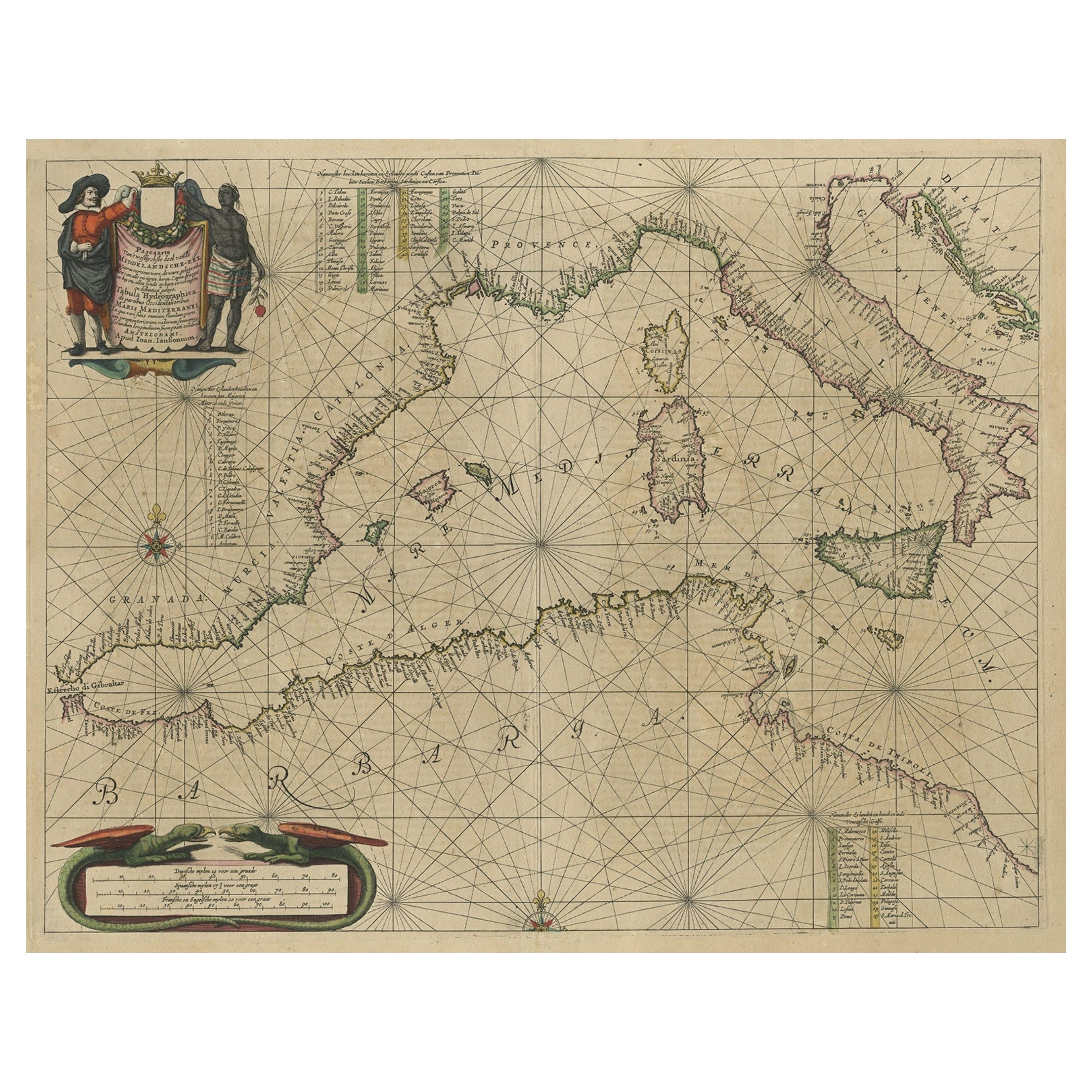
View AllOriginal Antique Engraving of a Sea Chart of the Western Mediterranean, ca.1650
Located in Langweer, NL
Antique map titled 'Pascaerte van 't westlyckste deel vande Middelandsche-Zee (..)'.
Sea chart of the Western Mediterranean. The map extends from the Straits of Gibralter to Italy ...
Category
Antique 1650s Maps
Materials
Paper

$1,197 Sale Price
20% Off
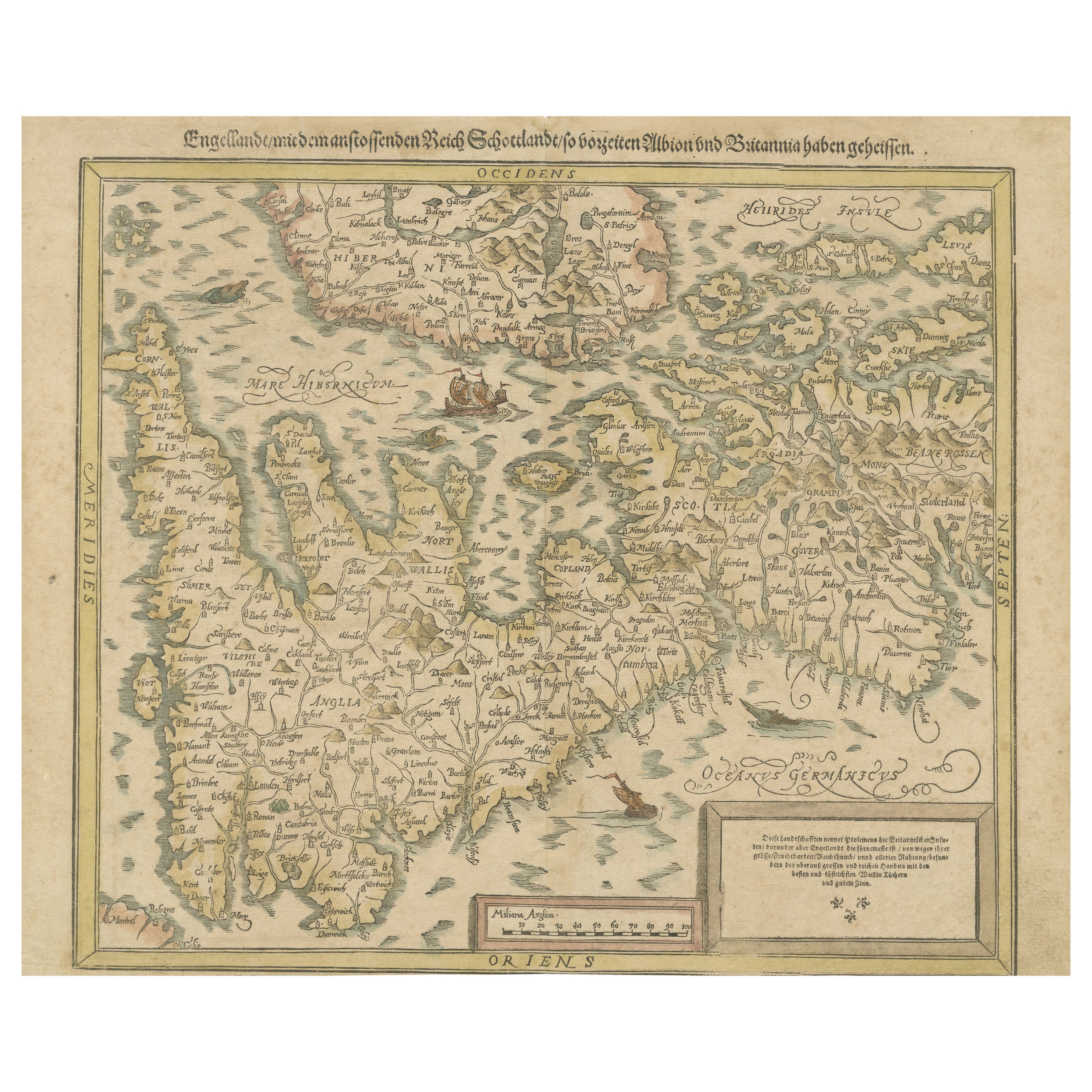
Sebastian Münster's 16th Century Map of the British Isles, ca.1590
Located in Langweer, NL
GREAT BRITAIN -- "ENGELLANDT mit dem anstossenden Reich Schottlandt so vorzeiten Albion und Britannia haben geheissen". (Basel, c. 1590).
Partly handcolored woodcut double-page map from S. Munster's 'Cosmographey'. 330 x 408 mm. (Lower margin cut short (touching the line), tiny hole in upper margin, sl. foxed/browned, lower right corner a bit thumbed).
Sebastian Münster's 16th Century Map of the British Isles from 'Cosmographia Universalis...
Category
Antique 16th Century Maps
Materials
Paper
$613 Sale Price
20% Off
Free Shipping
Antique Print of the Sea Voyage to Nova Zembla, Russia, circa 1730
Located in Langweer, NL
Antique print of the Dutch crew killing a walrus with ships in the background. This print originates from 'Histoire des Provinces-Unies des Pays Bas...', or 'Geschiedenissen der Vere...
Category
Antique Mid-18th Century Prints
Materials
Paper
$320 Sale Price
20% Off
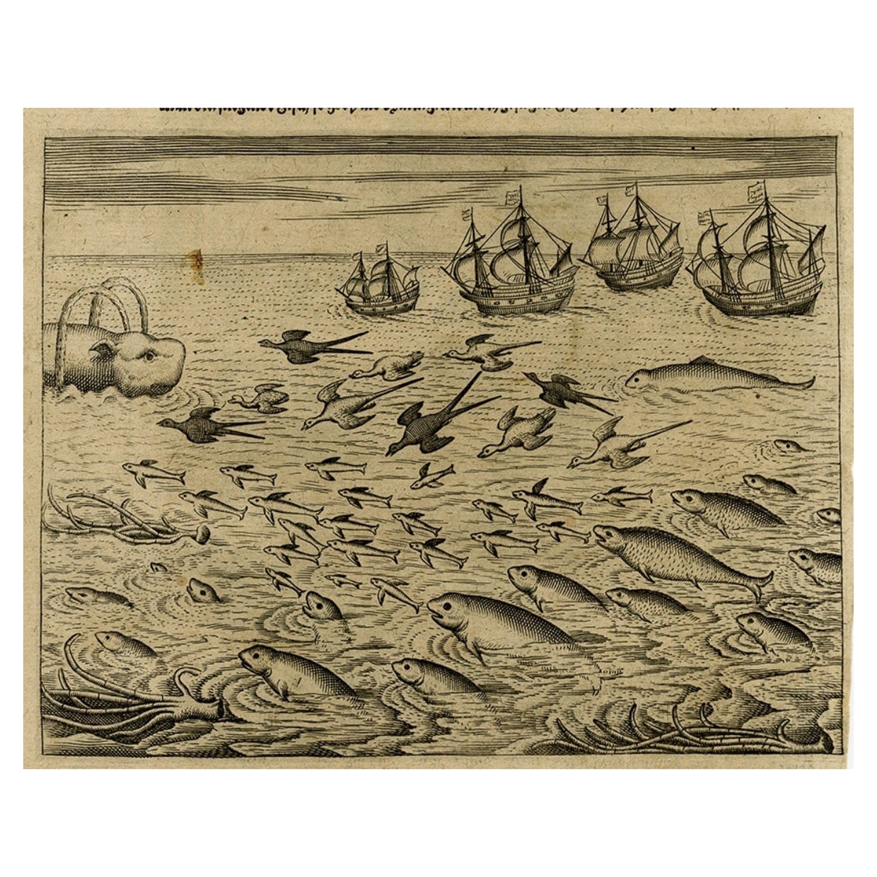
Old Print of Ascension Island with Ships, a Whale and Flying Fish, 1601
Located in Langweer, NL
Antique print, titled: 'Vera effigies et delineato Insulae Ascenstio …' - Bird's eye view of Ascension Island. Five large sailing ships in the background and flying fish and waterfowl in the foreground. On the rear an image of four ships sailing towards a whale, accompanied by fowl, flying fish and dolphins. From 'Indiae Orientalis', 1598-1604.
Artists and Engravers: Made by an anonymous engraver after 'Jean Theodore de Bry...
Category
Antique Early 1600s Prints
Materials
Paper
$268 Sale Price
20% Off
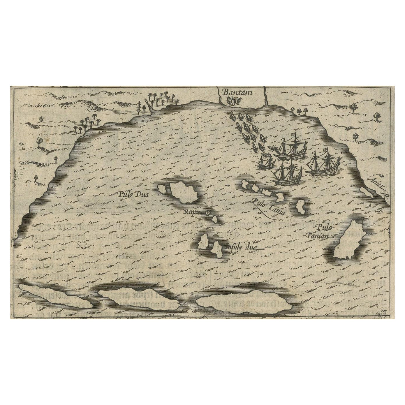
Small Map of Bantam with Dutch Ships and an Engraving of Portugese, 1614
Located in Langweer, NL
Two rare old miniature copper-engravings one one leaf. One showing the first arrival of the first Dutch in Indonesia, the so-called 'Houtman expedition' and on the reverse Portugese welcoming them with gifts.
The First Dutch Expedition to Indonesia was an expedition that took place from 1595 to 1597. It was instrumental in the opening up of the Indonesian spice trade...
Category
Antique Early 17th Century Maps
Materials
Paper
$718 Sale Price
20% Off
Old Map of The Kurile Islands, from Hokkaido, Japan to Kamchatka, Russia, c.1750
Located in Langweer, NL
Antique map titled 'Carte des Iles Kouriles'. Original antique map of the Kuril Islands.
The Kuril Islands or Kurile Islands are a volcanic archipelago that stretches approximate...
Category
Antique 1750s Maps
Materials
Paper
$316 Sale Price
20% Off
Free Shipping
You May Also Like
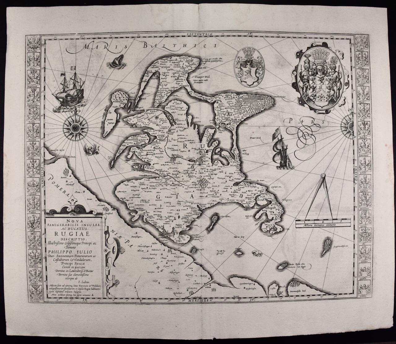
Rugen Island, Germany: An Early 17th Century Map by Mercator and Hondius
By Gerard Mercator
Located in Alamo, CA
This is an early 17th century map entitled "Nova Famigerabilis Insulae Ac Ducatus Rugiae Desciptio" (Map of Rugen Island, Germany) by Gerard Mercator and Henricus and Joducus Hondiu...
Category
Early 17th Century Old Masters Landscape Prints
Materials
Engraving

1646 Jansson Map Entitled "Procinvia Connactiae, " Ric.a006
Located in Norton, MA
1646 Jansson map entitled
"Procinvia connactiae,"
Ric.a006
Description: The PROVINCE of CONNAVGT 490 x 380From vol 4 of Jansson's Atlas Novus 1646, published in Amsterdam with...
Category
Antique 17th Century Unknown Maps
Materials
Paper

Ancient Map-Poli Arctici (Map of the Poles)-Etching by Johannes Janssonius-1650s
By Johannes Janssonius
Located in Roma, IT
Poli Arctici is an ancient map realized in 1650 by Johannes Janssonius (1588-1664).
The Map is a Hand-colored etching, with coeval watercoloring.
Good conditions with slight foxing...
Category
1650s Modern Figurative Prints
Materials
Etching

Ancient Map - Zeilan - Etching by Johannes Janssonius - 1650s
By Johannes Janssonius
Located in Roma, IT
Ancient Map - Zeilan is an ancient map realized in 1650 by Johannes Janssonius (1588-1664).
The Map is Hand-colored etching, with coeval watercoloring.
...
Category
1650s Modern Figurative Prints
Materials
Etching

Antique Map - Mare Pacificum - Etching by Johannes Janssonius - 1650s
By Johannes Janssonius
Located in Roma, IT
Mare Pacificum is an antique map realized in 1650 by Johannes Janssonius (1588-1664).
The Map is Hand-colored etching, with coeval watercolorang.
Good conditions with slight foxing...
Category
1650s Modern Figurative Prints
Materials
Etching

Engraving Depicting 16th Century Map of Terra Sancta
Located in Buchanan, MI
Abraham Ortelius (Flemish, 1527-1598) Terra Sancta.
Engraving depicting 16th century map of Terra Sancta. Site 15" x 19.5.
Category
Antique 18th Century and Earlier Maps
Materials
Paper

More Ways To Browse
Hunting Collectibles
Hunting Engravings
Antique Hunting Collectibles
Hunt Engraving
Antique Rowing
Copper Boat
Russian Seal
Whale Engraving
Framed Map Of Paris
Used Nautical Charts
Antique Navigator
Map Of Middle East
Antique Map Of Switzerland
World Map Copper
British Empire Map
Malaysian Antique Furniture
Birds Eye View Map
Map Of Arabia