Items Similar to Rare Map of St. Louis on the Island of Hispaniola 'Santa Domingo', 1748


Want more images or videos?
Request additional images or videos from the seller
1 of 5
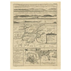
Rare Map of St. Louis on the Island of Hispaniola 'Santa Domingo', 1748
$335.77
$419.7120% Off
£249.78
£312.2220% Off
€280
€35020% Off
CA$459.78
CA$574.7320% Off
A$511.22
A$639.0220% Off
CHF 266.93
CHF 333.6620% Off
MX$6,222.76
MX$7,778.4520% Off
NOK 3,405.90
NOK 4,257.3820% Off
SEK 3,191.17
SEK 3,988.9620% Off
DKK 2,131.49
DKK 2,664.3620% Off
Shipping
Retrieving quote...The 1stDibs Promise:
Authenticity Guarantee,
Money-Back Guarantee,
24-Hour Cancellation
About the Item
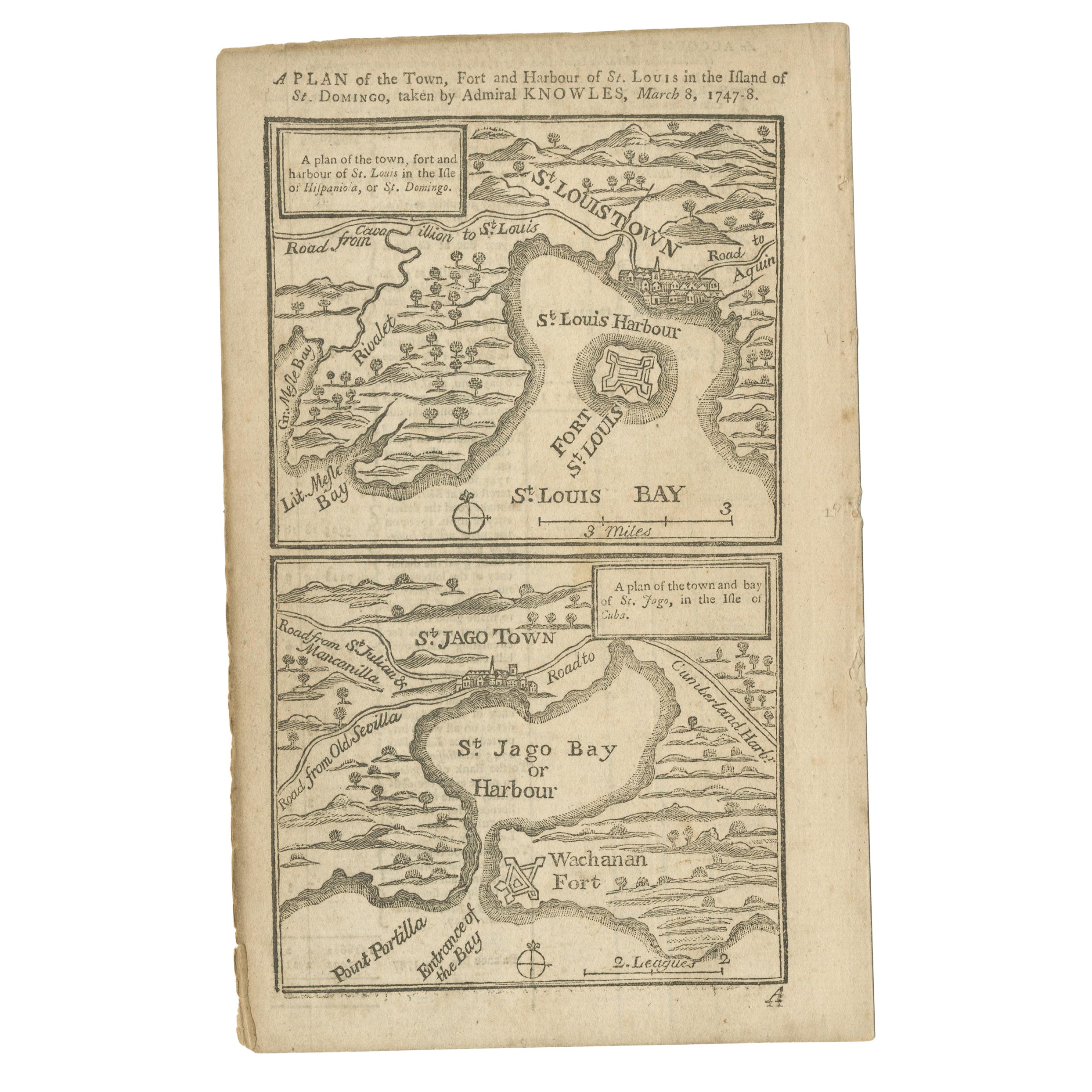
Description: Antique map titled 'A New & Exact Planof the Harbour of Port Louis (..)'.
Scarce early plan of the Harbor of St. Louis on the Island of Hispaniola (Santa Domingo), showing the the harbor at the time it was taken by Admiral Knowles in March 1748. Charles Knowles (1704 – 1777) was an officer of the Royal Navy, who saw service during the War of Jenkins' Ear, the War of the Austrian Succession, and the Seven Years War. He also briefly served with the Imperial Russian Navy during the Russo-Turkish War.
Artists and Engravers: Engraver: F. Vallnight.
Condition: Very good, given age. Please study scan carefully.
- Dimensions:Height: 7.92 in (20.1 cm)Width: 5.01 in (12.7 cm)Depth: 0 in (0.02 mm)
- Materials and Techniques:
- Period:1740-1749
- Date of Manufacture:1748
- Condition:Wear consistent with age and use.
- Seller Location:Langweer, NL
- Reference Number:Seller: BL-00077 1stDibs: LU3054326445742
About the Seller
5.0
Recognized Seller
These prestigious sellers are industry leaders and represent the highest echelon for item quality and design.
Platinum Seller
Premium sellers with a 4.7+ rating and 24-hour response times
Established in 2009
1stDibs seller since 2017
2,510 sales on 1stDibs
Typical response time: <1 hour
- ShippingRetrieving quote...Shipping from: Langweer, Netherlands
- Return Policy
Authenticity Guarantee
In the unlikely event there’s an issue with an item’s authenticity, contact us within 1 year for a full refund. DetailsMoney-Back Guarantee
If your item is not as described, is damaged in transit, or does not arrive, contact us within 7 days for a full refund. Details24-Hour Cancellation
You have a 24-hour grace period in which to reconsider your purchase, with no questions asked.Vetted Professional Sellers
Our world-class sellers must adhere to strict standards for service and quality, maintaining the integrity of our listings.Price-Match Guarantee
If you find that a seller listed the same item for a lower price elsewhere, we’ll match it.Trusted Global Delivery
Our best-in-class carrier network provides specialized shipping options worldwide, including custom delivery.More From This Seller
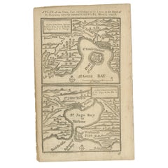
View AllAntique Map of Fort Saint Louis and Santiago de Cuba, 1748
Located in Langweer, NL
Antique map titled 'A plan of the town, fort and harbour of St Louis in the Isle of Hispaniola, or St Domingo / A plan of the town and bay of St. Jago, in the Isle if Cuba'. Two woodcut maps on one sheet, illustrating Admiral Sir Charles Knowles’ successful attack on Fort Saint Louis de Sud...
Category
Antique 18th Century Maps
Materials
Paper
$182 Sale Price
20% Off
Antique Map of the Bay of Batavia by Van der Aa, c.1720
Located in Langweer, NL
Antique map titled 'La Rade de Batavia'. A small early 18th century black and white map of the Bay of Batavia (Jakarta), Indonesia. Published by P....
Category
Antique 18th Century Maps
Materials
Paper

$259 Sale Price
20% Off
Antique Map of Anjouan Island by Valentijn, 1726
By F. Valentijn
Located in Langweer, NL
Antique map titled 'Anzuany'. This map depicts the island of Anjouan, one of the Comoros islands situated between Madagascar and Africa. The map is oriented with north to the left wi...
Category
Antique Early 18th Century Dutch Maps

Antique Map of Guadelupe in the Caribbean, 1759
By Jacques-Nicolas Bellin
Located in Langweer, NL
Antique map titled 'Carte De L'Isle De La Guadeloupe'. Detailed map of Guadalupe, Mari-Galante and the Isles de Saintes. Produced by Nichlas Bellin for Prevost d'Exiles influential t...
Category
Antique Mid-18th Century French Maps
Materials
Paper

Antique Map of Martinique, Showing Roads, Houses, Sugar Plantations, etc. c.1750
Located in Langweer, NL
Antique map titled 'Carte de l'Isle de la Martinique'.
Detailed map of Martinique. Shows hilly terrain, forests, roads, houses, and even the sugar plantations. The island was to ...
Category
Antique 18th Century Maps
Materials
Paper
$1,439 Sale Price
20% Off
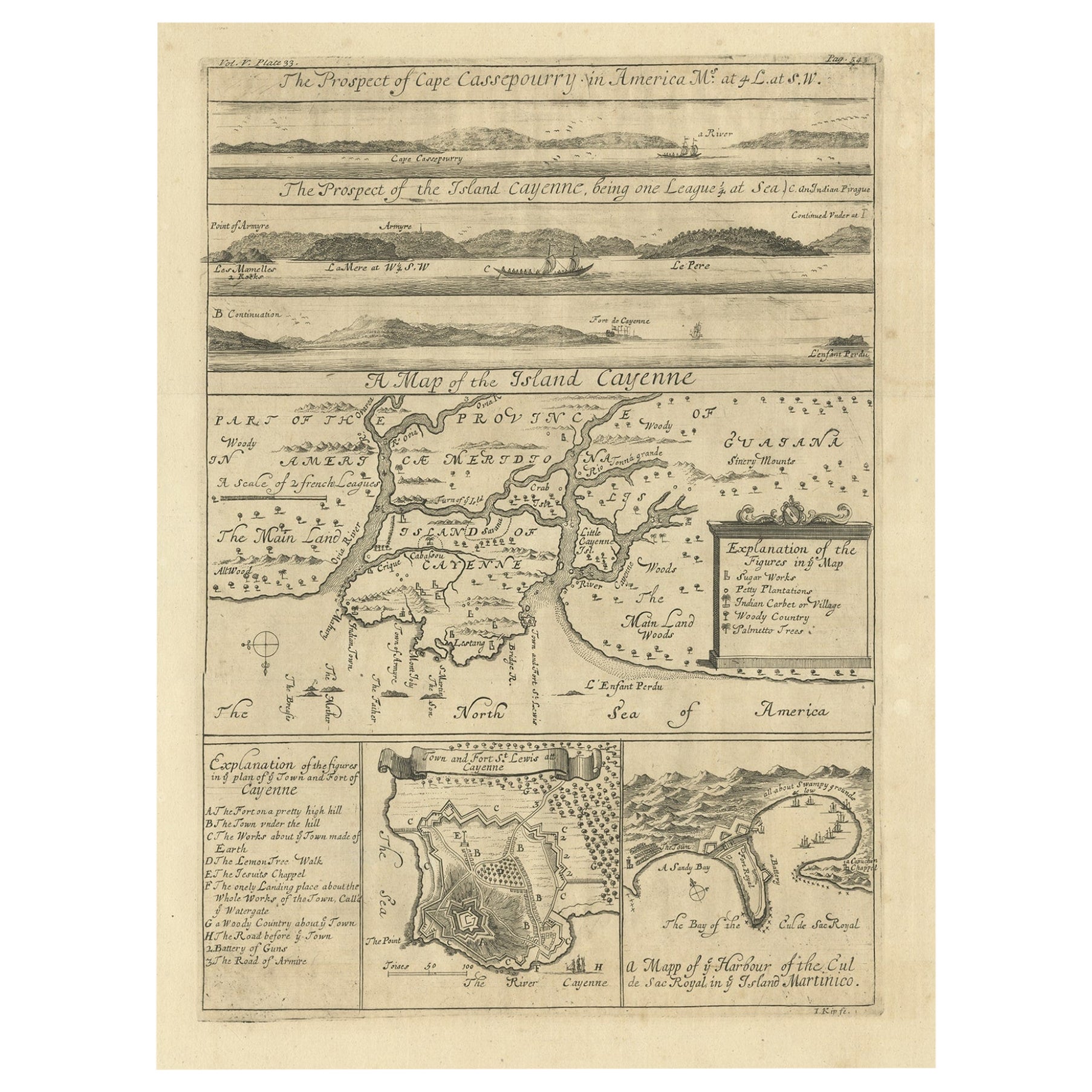
Antique Map of Cayenne and Cassepouri, French Guinea, South America, c.1730
Located in Langweer, NL
Antique map titled 'A Map of the Island Cayenne (..)’. A set of interesting copper engravings of Cayenne and Cassepouri, French Guinea, South America, and Martinique in the West Indies. The map of Cayenne, home of Cayenne pepper, has a key of symbols identifying the sugar works, petty plantations, indian carbet or village, woody country and palmetto trees. The plan of Fort Lewis, Cayenne also has a lettered key including; A. the fort on a pretty high hill...
Category
Antique 18th Century Maps
Materials
Paper
$364 Sale Price
20% Off
You May Also Like
Rugen Island, Germany: An Early 17th Century Map by Mercator and Hondius
By Gerard Mercator
Located in Alamo, CA
This is an early 17th century map entitled "Nova Famigerabilis Insulae Ac Ducatus Rugiae Desciptio" (Map of Rugen Island, Germany) by Gerard Mercator and Henricus and Joducus Hondiu...
Category
Early 17th Century Old Masters Landscape Prints
Materials
Engraving

West Coast of Africa, Guinea & Sierra Leone: An 18th Century Map by Bellin
By Jacques-Nicolas Bellin
Located in Alamo, CA
Jacques Bellin's copper-plate map entitled "Partie de la Coste de Guinee Dupuis la Riviere de Sierra Leona Jusquau Cap das Palmas", depicting the coast of Guinea and Sierra Leone in ...
Category
Antique Mid-18th Century French Maps
Materials
Paper

1627 Hendrik Hondius Map Entitled "Vltoniae Orientalis Pars, " Ric.a009
Located in Norton, MA
1627 Hendrik Hondius map entitled
"Vltoniae orientalis pars,"
Ric.a009
Title:
Vltoniae orientalis : pars
Title (alt.) :
Ultoniae orientalis pars
Creator:
Mercator, Gerh...
Category
Antique 17th Century Dutch Maps
Materials
Paper

1646 Jansson Map Entitled "Procinvia Connactiae, " Ric.a006
Located in Norton, MA
1646 Jansson map entitled
"Procinvia connactiae,"
Ric.a006
Description: The PROVINCE of CONNAVGT 490 x 380From vol 4 of Jansson's Atlas Novus 1646, published in Amsterdam with...
Category
Antique 17th Century Unknown Maps
Materials
Paper

Antique Map - Gallia - Etching by Johannes Janssonius - 1650s
By Johannes Janssonius
Located in Roma, IT
Antique Map - Gallia is an antique map realized in 1650 by Johannes Janssonius (1588-1664).
The Map is Hand-colored etching, with coeval watercoloring.
Good conditions with slight ...
Category
1650s Modern Figurative Prints
Materials
Etching

Ancient Map - Zeilan - Etching by Johannes Janssonius - 1650s
By Johannes Janssonius
Located in Roma, IT
Ancient Map - Zeilan is an ancient map realized in 1650 by Johannes Janssonius (1588-1664).
The Map is Hand-colored etching, with coeval watercoloring.
...
Category
1650s Modern Figurative Prints
Materials
Etching

More Ways To Browse
Royal Navy Antique
Map Of Holy Land
Antique Macedonia
Antique Maps Of New York City
Victorian Compass
Antique Maps Caribbean Islands
Hungary Map
Cartographer Tool
Goa Furniture
George Fleet
Sri Lanka Map
Philippines Map
Antique Map Ceylon
Antique Sri Lanka Map
Persian Maps
Antique Civil War Maps
Antique Map Of The Philippines
Large Map Of Italy