Items Similar to Small Map of St. Anna Bay and Willemstad, Curaçao – Dutch Colonial View, c. 1880


Want more images or videos?
Request additional images or videos from the seller
1 of 10
Small Map of St. Anna Bay and Willemstad, Curaçao – Dutch Colonial View, c. 1880
$296.45
£220.96
€250
CA$406.81
A$455.52
CHF 237.67
MX$5,550.19
NOK 3,015.84
SEK 2,867.26
DKK 1,903.41
Shipping
Retrieving quote...The 1stDibs Promise:
Authenticity Guarantee,
Money-Back Guarantee,
24-Hour Cancellation
About the Item
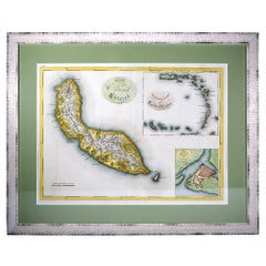
Map of St. Anna Bay and Willemstad, Curaçao – Dutch Colonial View, c. 1880
This attractive late 19th-century map titled “De St. Anna-baai en de hoofdstad van Curaçao” offers a detailed topographic and urban depiction of the island of Curaçao and its capital, Willemstad, centered around the vital waterway of St. Anna Bay. This lithographed map, printed circa 1880 in the Netherlands, is hand-colored and was likely intended for a Dutch school atlas or geographic publication.
The map covers both the densely developed southern shore of the bay—home to the capital—and the surrounding inland plantation lands, neighborhoods, and military installations. Notable locations like Pietermaai, Otrabanda, Scharloo, Punda, and Riffort are clearly marked, along with prominent estates such as Welgelegen, Zeelandia, and Rustenburg.
A legend at the upper left lists numbered locations, including:
1. Government House
2. Reformed Church
3. Synagogue
4. Roman Catholic Church
5. Hospital
6. Cemeteries
7. Forts
8. Plantations
The town’s structure is shown in fine detail with red-tinted buildings, road networks, and shaded elevation, while the blue-toned bay and Rifwater channel emphasize the harbor’s strategic and economic importance. On the bottom left, the entire island of Curaçao is inset for broader context, complete with place names such as Willemstad, St. Kruis, Bullenbaai, and Klein Curaçao.
This map is a valuable visual artifact from the Dutch colonial era, offering insight into the layout, administration, and function of Curaçao as a Caribbean port and naval station under Dutch rule. The contrast between the fortified city, its churches and synagogues, and the surrounding plantation economy is clearly visible.
Condition report:
Good condition. Light age toning. Original hand coloring remains vibrant. No tears. Light text bleed-through from verso, typical for the period. Ample margins for framing.
Framing suggestion:
A modern archival mat in soft ivory with a thin black or colonial-style wood frame complements the cartographic detail and period charm. Consider UV-protective glass to preserve the delicate hand-coloring.
- Dimensions:Height: 5.6 in (14.2 cm)Width: 7.33 in (18.6 cm)Depth: 0.01 in (0.2 mm)
- Materials and Techniques:
- Period:
- Date of Manufacture:circa 1880
- Condition:Good condition. Light age toning. Original hand coloring remains vibrant. No tears. Light text bleed-through from verso, typical for the period. Ample margins for framing.
- Seller Location:Langweer, NL
- Reference Number:Seller: BG-034461stDibs: LU3054344978092
About the Seller
5.0
Recognized Seller
These prestigious sellers are industry leaders and represent the highest echelon for item quality and design.
Platinum Seller
Premium sellers with a 4.7+ rating and 24-hour response times
Established in 2009
1stDibs seller since 2017
2,493 sales on 1stDibs
Typical response time: <1 hour
- ShippingRetrieving quote...Shipping from: Langweer, Netherlands
- Return Policy
Authenticity Guarantee
In the unlikely event there’s an issue with an item’s authenticity, contact us within 1 year for a full refund. DetailsMoney-Back Guarantee
If your item is not as described, is damaged in transit, or does not arrive, contact us within 7 days for a full refund. Details24-Hour Cancellation
You have a 24-hour grace period in which to reconsider your purchase, with no questions asked.Vetted Professional Sellers
Our world-class sellers must adhere to strict standards for service and quality, maintaining the integrity of our listings.Price-Match Guarantee
If you find that a seller listed the same item for a lower price elsewhere, we’ll match it.Trusted Global Delivery
Our best-in-class carrier network provides specialized shipping options worldwide, including custom delivery.More From This Seller
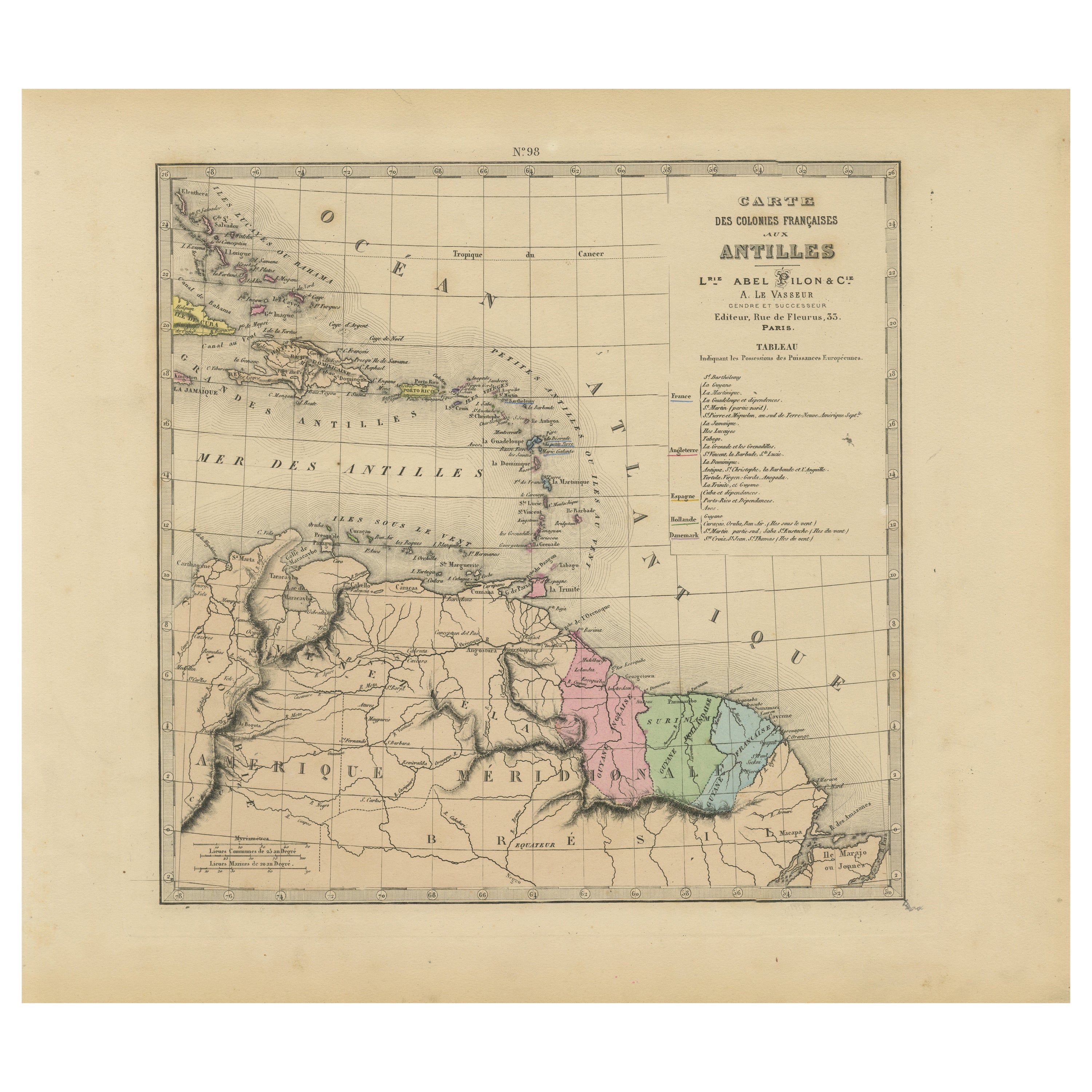
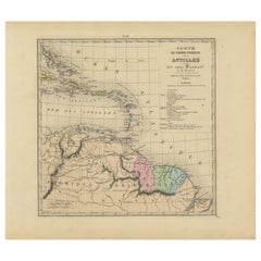
View AllAuthentique Map by Pilon of The French Colonies in The West Indies, 1876
Located in Langweer, NL
The 1876 map titled "Carte des Colonies Françaises aux Antilles" represents a significant contribution to cartography within the "Grand Atlas Départemental de la France de L'Algérie ...
Category
Antique Late 19th Century Maps
Materials
Paper
$227 Sale Price
20% Off
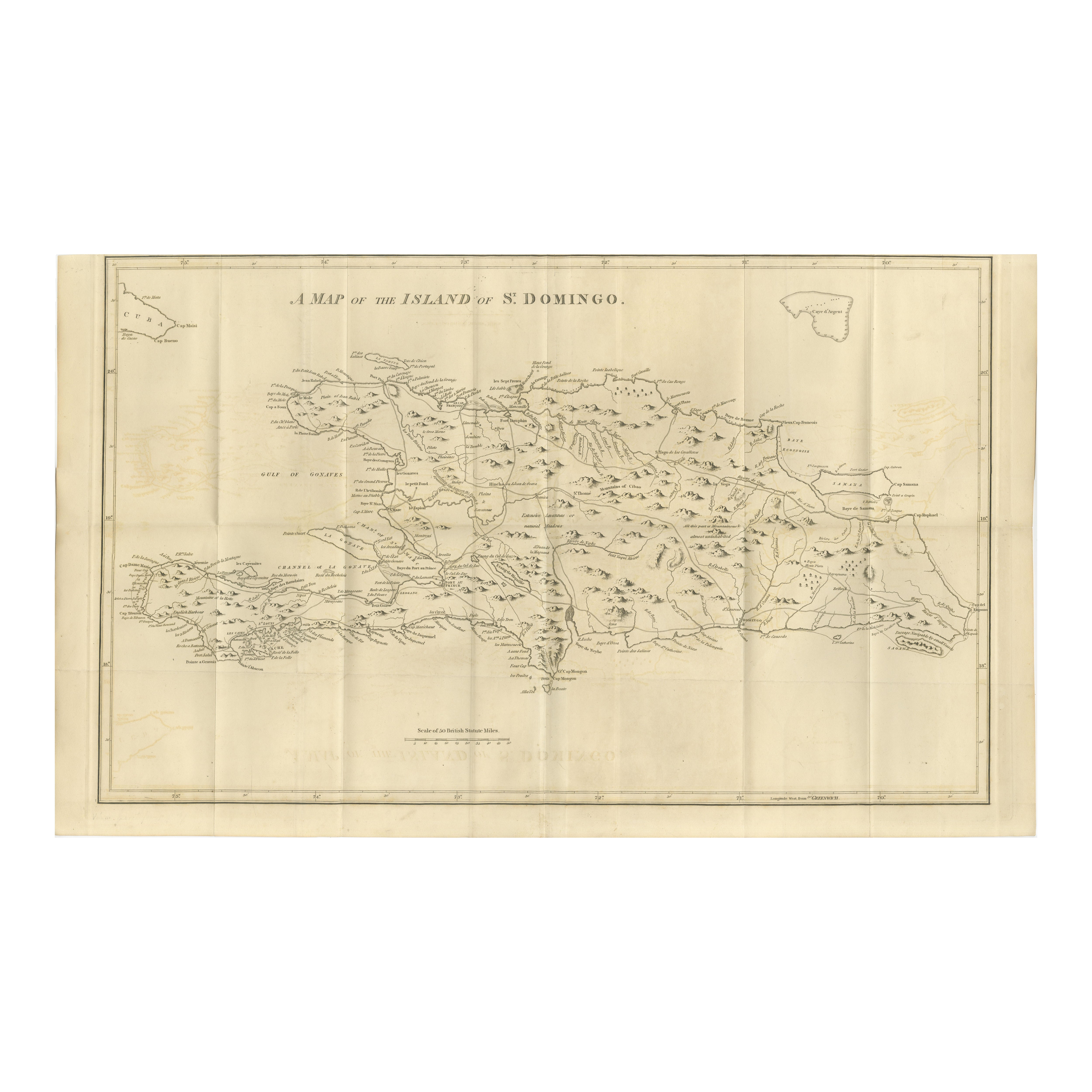
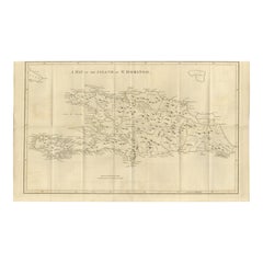
Saint Domingue Map 1793 – Colonial Haiti and Dominican Republic Plan
Located in Langweer, NL
1793 Map of Saint Domingue (Haiti and DR) – Colonial Island Plan
This antique map is titled “A Map of the Island of St. Domingo” and dates from circa 1793. It depicts the entire isl...
Category
Antique Late 18th Century English Maps
Materials
Paper
Martinique Map by Rigobert Bonne – French Antique Map, c.1768
Located in Langweer, NL
Map of Martinique by Rigobert Bonne, circa 1768
This is a detailed antique map of Martinique titled “Isle de la Martinique,” engraved by Rigobert Bonne around 1768 for the Atlas Encyclopédique. Bonne, a renowned French hydrographer and successor to Bellin, is celebrated for his scientifically precise and elegantly engraved maps.
The map shows Martinique with its mountainous interior, rivers, and settlements labelled, including Fort Royal, Fort St. Pierre, Le Marin, and Le Prêcheur. Coastal features, bays, and capes are marked, along with anchorages important for maritime navigation in the 18th century. The depiction includes relief shown pictorially, characteristic of Bonne’s cartographic style, enhancing both geographic understanding and aesthetic appeal.
This copperplate engraving retains original hand colouring outlining the coastlines in delicate blue and brown tones, typical for the period. It served as a key reference for scholars, navigators, and colonial administrators during France’s colonial presence in the Caribbean.
Condition:
Good condition overall. A strong impression with bright, original hand-colour outlines. General age toning, faint offsetting, and a vertical fold as issued in the atlas. Margins ample all around for framing.
Framing suggestions:
This historic Caribbean map...
Category
Antique 1760s French Maps
Materials
Paper

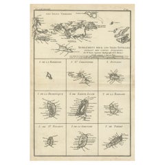
Map of Virgin Islands and Lesser Antilles by Rigobert Bonne, c. 1780
Located in Langweer, NL
Map of Virgin Islands and Lesser Antilles by Rigobert Bonne, c. 1780
This fine antique map is titled 'Supplément pour les Isles Antilles, extrait des cartes angloises' and was engraved by Rigobert Bonne, Ingénieur-Hydrographe de la Marine, around 1780. It depicts:
Upper half:
* The Virgin Islands (*Les Isles Vierges*), including:
* St. Thomas
* St. John
* Tortola
* Virgin Gorda
* Jost Van Dyke
* Surrounding smaller islands and passages.
* Parts of Puerto Rico visible left.
Lower half:
Nine inset maps of individual Caribbean islands with coastal details:
1. I. de la Barboude (Barbuda)
2. I. St. Christophe (St. Kitts)
3. I. Antigoa (Antigua)
4. I. de la Dominique (Dominica)
5. I. de Sainte Lucie (St. Lucia)
6. I. de la Barbade (Barbados)
7. I. de St. Vincent
8. I. de la Grenade (Grenada)
9. I. de Tabago (Tobago)
Features:
* Coastal names, bays, capes, and harbours noted.
* Fine clear engraving typical of Bonne’s atlases for maritime use.
* Scale bar with French lieues marines.
Engraver: Rigobert Bonne
Date: circa 1780
Published in: Atlas Encyclopédique
Condition:
Good dark impression on laid paper with wide margins. Some slight toning along centre fold and faint edge wear consistent with age. Original platemark visible.
Framing suggestions:
Display with other Bonne Caribbean or West Indies maps in a travel, history, or colonial themed wall. Ideal floated in a black or walnut wood frame with archival matting to preserve the crisp engraving.
Keywords:
Rigobert Bonne Caribbean maps...
Category
Antique 1780s French Maps
Materials
Paper
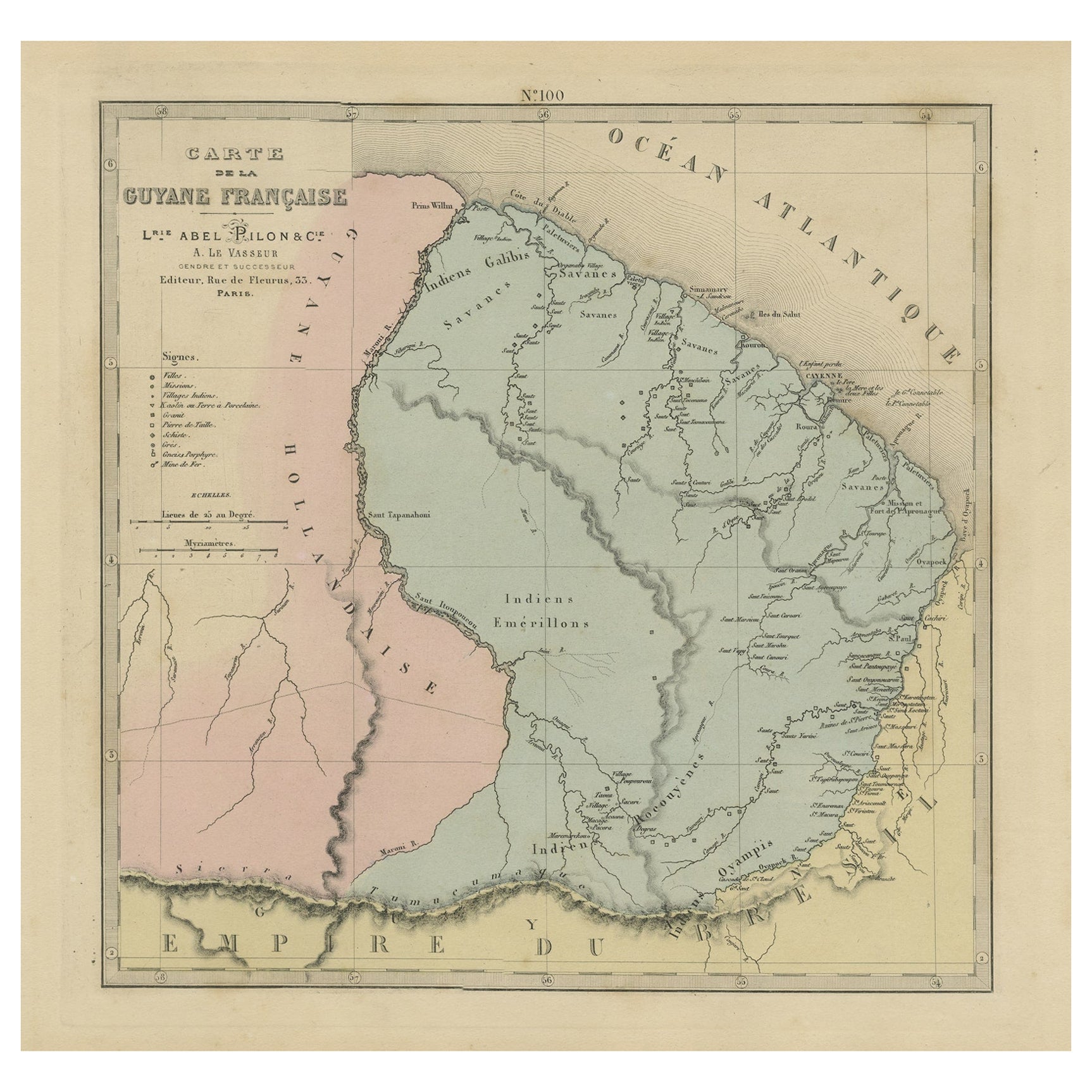
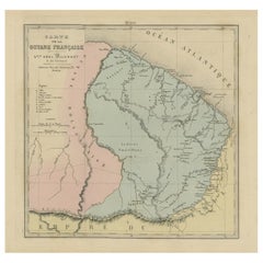
Antique Engraved Map with Original Hand Colour of French Guiana, 1876
Located in Langweer, NL
The 1876 map of French Guiana from the "Grand Atlas Départemental de la France de L'Algérie et des colonies" by H. Fisquet, published by A. Le Vasseur in Paris, is a significant piec...
Category
Antique Late 19th Century Maps
Materials
Paper
$265 Sale Price
20% Off
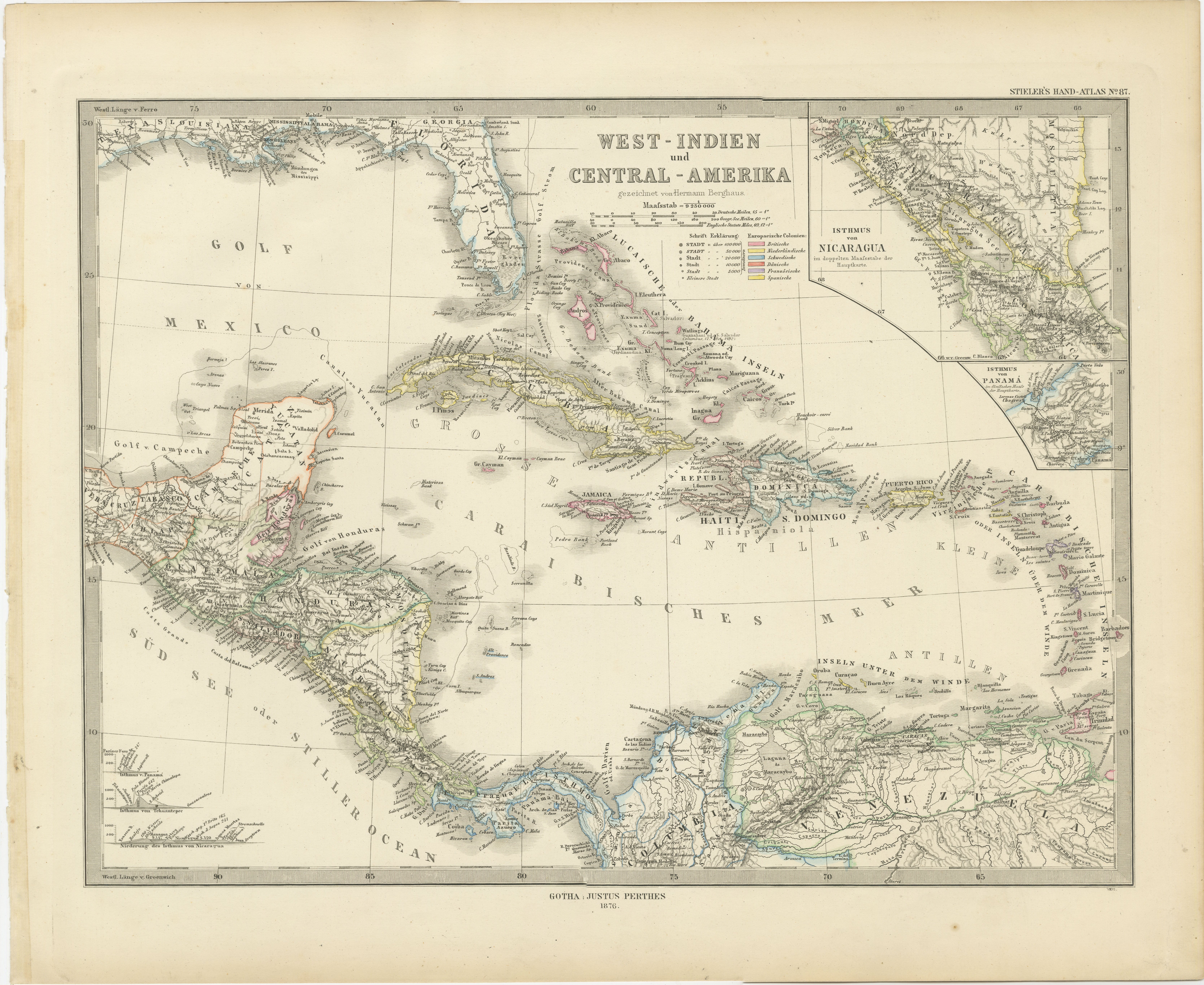
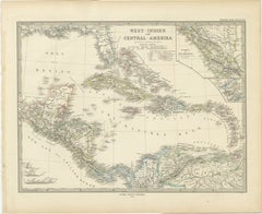
1880 Map of the Caribbean and Central America by Adolf Stieler
Located in Langweer, NL
This is a detailed map titled "West-Indien und Central-Amerika," created by Adolf Stieler and published in Gotha in 1880. The map covers the Caribbean islands and the Central America...
Category
Antique 1880s Maps
Materials
Paper
$275 Sale Price
20% Off
You May Also Like
Curaçao map - C. van Baarsel en zoon
Located in UTRECHT, UT
“Kaart van het eiland Curaçao.”, “Algemeene kaart der Caraïbische eilanden”, “Plan van het fort Amsterdam op Curaçao” from the atlas “Atlas der overzeesche bezittingen van Zijne Maje...
Category
Antique 1810s Dutch Other Maps
Materials
Paper
Map Of Martinique - Etching - 19th Century
Located in Roma, IT
Map Of Martinique is an etching realized by an anonymous engraver of the 19th Century.
Printed within the series "France Pittoresque" at the top center.
The state of preservation o...
Category
19th Century Modern Figurative Prints
Materials
Etching

Large Original Antique Map of The West Indies by Sidney Hall, 1847
Located in St Annes, Lancashire
Great map of The West Indies
Drawn and engraved by Sidney Hall
Steel engraving
Original colour outline
Published by A & C Black. 1847
Unframed
Free shipping.
Category
Antique 1840s Scottish Maps
Materials
Paper

Map Colonies Francaises Martinique, 1845
Located in BUNGAY, SUFFOLK
Colonies Francaises, Martinique, Amerique DU SUD
Geographie et Statistique par V.Levasseur. Ing'r Geographe.
Illustre par Raymond Bonheur, peintre.
Grave par Laguihermie, Rue St...
Category
Antique 19th Century French Maps
Materials
Paper

Large Original Antique Map of The Leeward Islands. 1894
Located in St Annes, Lancashire
Superb Antique map of The Leeward Islands
Published Edward Stanford, Charing Cross, London 1894
Original colour
Good condition
Unframed.
Free shipping
Category
Antique 1890s English Maps
Materials
Paper

Large Original Antique Map of The Bahamas. 1894
Located in St Annes, Lancashire
Superb Antique map of The Bahamas
Published Edward Stanford, Charing Cross, London 1894
Original colour
Good condition
Unframed.
Free shipping
Category
Antique 1890s English Maps
Materials
Paper

More Ways To Browse
Southern Colonial
Antique Church Light
Antique Ivory Collectables
Antique Hospital
Roman Capital
Antique Hospital Furniture
Dutch Military
Used Synagogue Furniture
Silver Bowl Large
Down Couch
Used Lighter Art
Blue Edge Glass
Mahogany 1950s Furniture
Solid Mahogany Table
Dessert Glasses
Geometric Glass Table
Mid Century Pin
6x10 Rug