Items Similar to Small Old Map Depicting the Banda Islands or the Spice Islands, Indonesia, 1706

Want more images or videos?
Request additional images or videos from the seller
1 of 5
Small Old Map Depicting the Banda Islands or the Spice Islands, Indonesia, 1706
On Hold
$517.42
$646.7820% Off
On Hold
£383.44
£479.3020% Off
On Hold
€432
€54020% Off
On Hold
CA$706.38
CA$882.9820% Off
On Hold
A$785.82
A$982.2820% Off
On Hold
CHF 411.94
CHF 514.9220% Off
On Hold
MX$9,602.53
MX$12,003.1720% Off
On Hold
NOK 5,245.50
NOK 6,556.8820% Off
On Hold
SEK 4,937.92
SEK 6,172.3920% Off
On Hold
DKK 3,289.21
DKK 4,111.5120% Off
Shipping
Retrieving quote...The 1stDibs Promise:
Authenticity Guarantee,
Money-Back Guarantee,
24-Hour Cancellation
About the Item
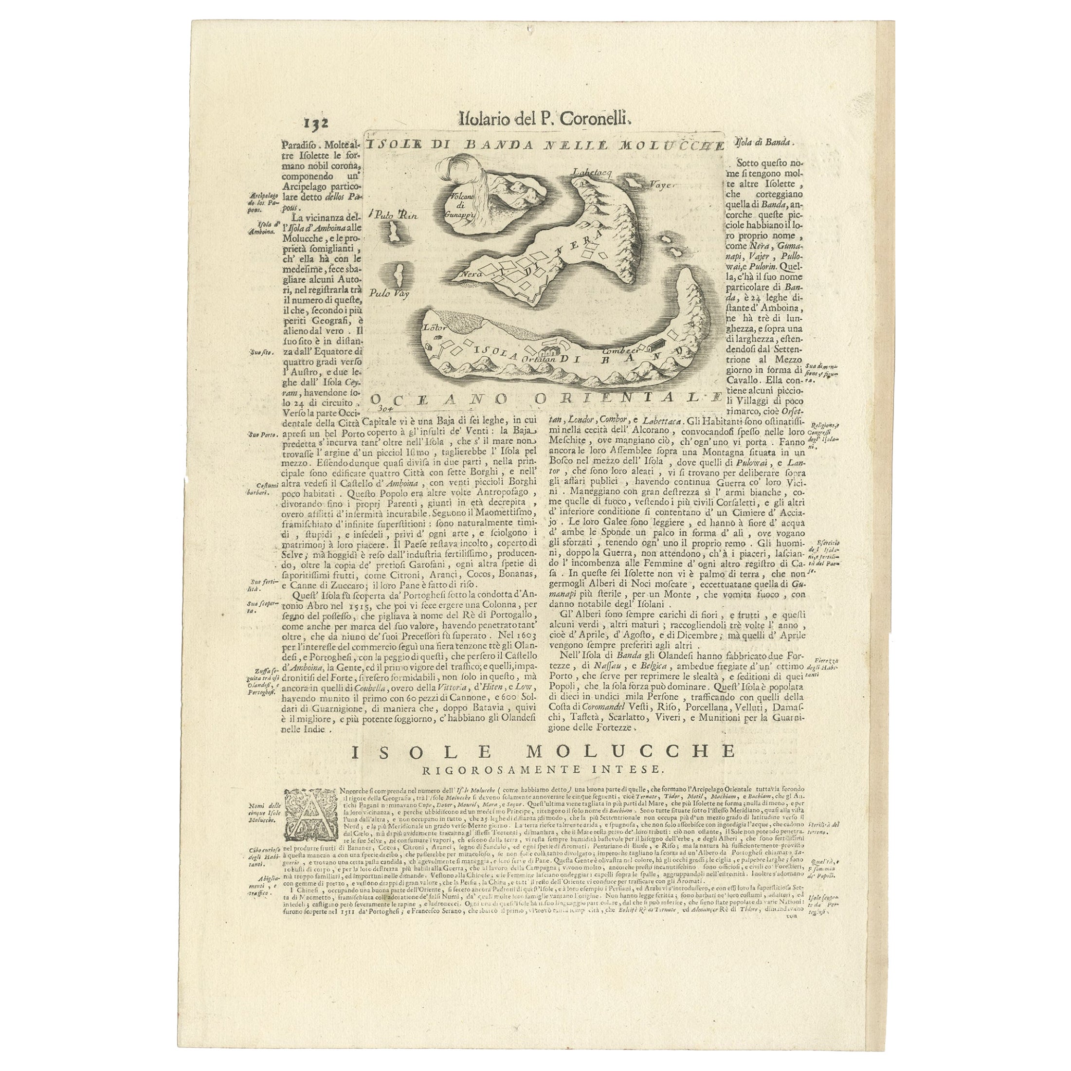
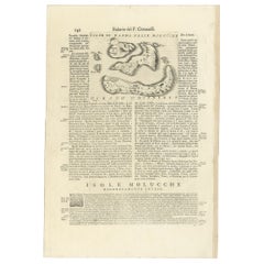
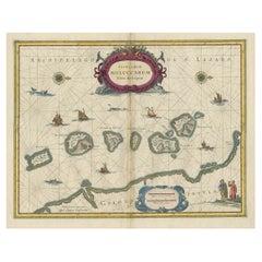
Antique map titled 'Isole di Banda Nelle Molucche'.
Small old map depicting the Banda Islands, Indonesia.
Artists and Engravers: Published by V.M. Coronelli in Venice, 1706.
- Dimensions:Height: 7.09 in (18 cm)Width: 8.86 in (22.5 cm)Depth: 0 in (0.02 mm)
- Materials and Techniques:
- Period:1700-1709
- Date of Manufacture:1706
- Condition:Wear consistent with age and use. Condition: Good, few small worm holes outside image border. Please study image carefully.
- Seller Location:Langweer, NL
- Reference Number:Seller: BG-11670-5 1stDibs: LU3054326936312
About the Seller
5.0
Recognized Seller
These prestigious sellers are industry leaders and represent the highest echelon for item quality and design.
Platinum Seller
Premium sellers with a 4.7+ rating and 24-hour response times
Established in 2009
1stDibs seller since 2017
2,502 sales on 1stDibs
Typical response time: <1 hour
- ShippingRetrieving quote...Shipping from: Langweer, Netherlands
- Return Policy
Authenticity Guarantee
In the unlikely event there’s an issue with an item’s authenticity, contact us within 1 year for a full refund. DetailsMoney-Back Guarantee
If your item is not as described, is damaged in transit, or does not arrive, contact us within 7 days for a full refund. Details24-Hour Cancellation
You have a 24-hour grace period in which to reconsider your purchase, with no questions asked.Vetted Professional Sellers
Our world-class sellers must adhere to strict standards for service and quality, maintaining the integrity of our listings.Price-Match Guarantee
If you find that a seller listed the same item for a lower price elsewhere, we’ll match it.Trusted Global Delivery
Our best-in-class carrier network provides specialized shipping options worldwide, including custom delivery.More From This Seller
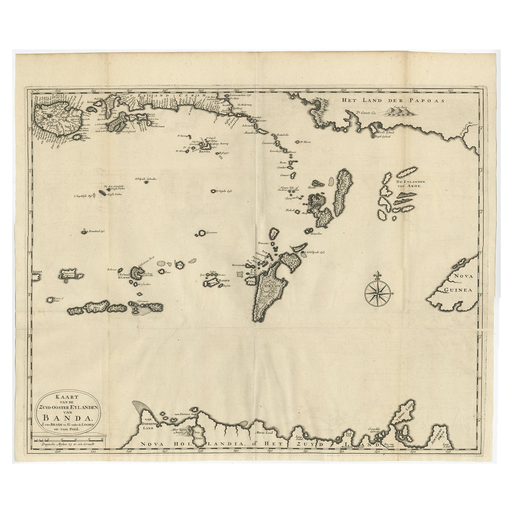
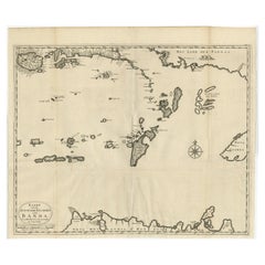
View AllOriginal Antique Map Southeast of the Banda or Spice Islands, Indonesia, 1726
Located in Langweer, NL
Antique map titled 'Kaart van de Zuyd-Ooster Eylanden van Banda'.
Map of the southeastern part of the Banda islands. This map originates from 'Oud en Nieuw Oost-Indiën' by F. Valen...
Category
Antique 1720s Maps
Materials
Paper
$737 Sale Price
20% Off
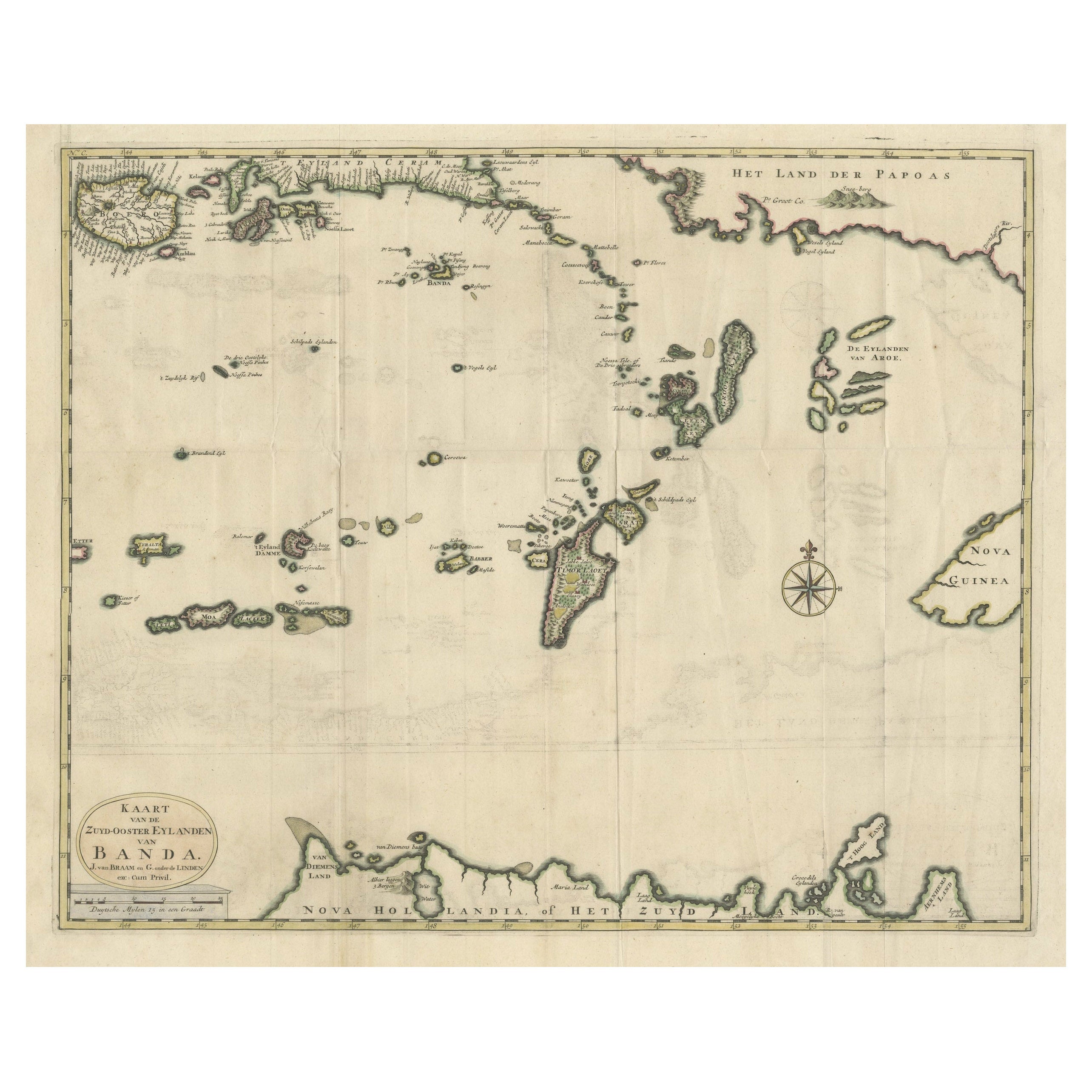
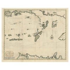
Old Antique Map of the Banda Islands (Southeast), Indonesia & Northern Australia
By F. Valentijn
Located in Langweer, NL
Original antique map titled 'Kaart van de Zuyd-Ooster Eylanden van Banda'. Important map of the seas and islands surrounding the Banda Islands, Indonesia, extending south to northern Australia, east to Papua New Guinea and north to Ceram. Published 1724-1726 by Joannes van Braam...
Category
Antique Early 18th Century Maps
Materials
Paper
$737 Sale Price
20% Off
Antique Map of the Banda Islands or Spice Islands, Moluccas, Indonesia, 1697
Located in Langweer, NL
Antique map titled 'Isole di Banda Nelle Molucche'.
Engraved map of Isola di Banda, Nelle, Molucche. On verso: 'Isola di Solor'.
Artists and Engravers: Vincenzo Maria (Padre)...
Category
Antique 17th Century Maps
Materials
Paper
$431 Sale Price
20% Off
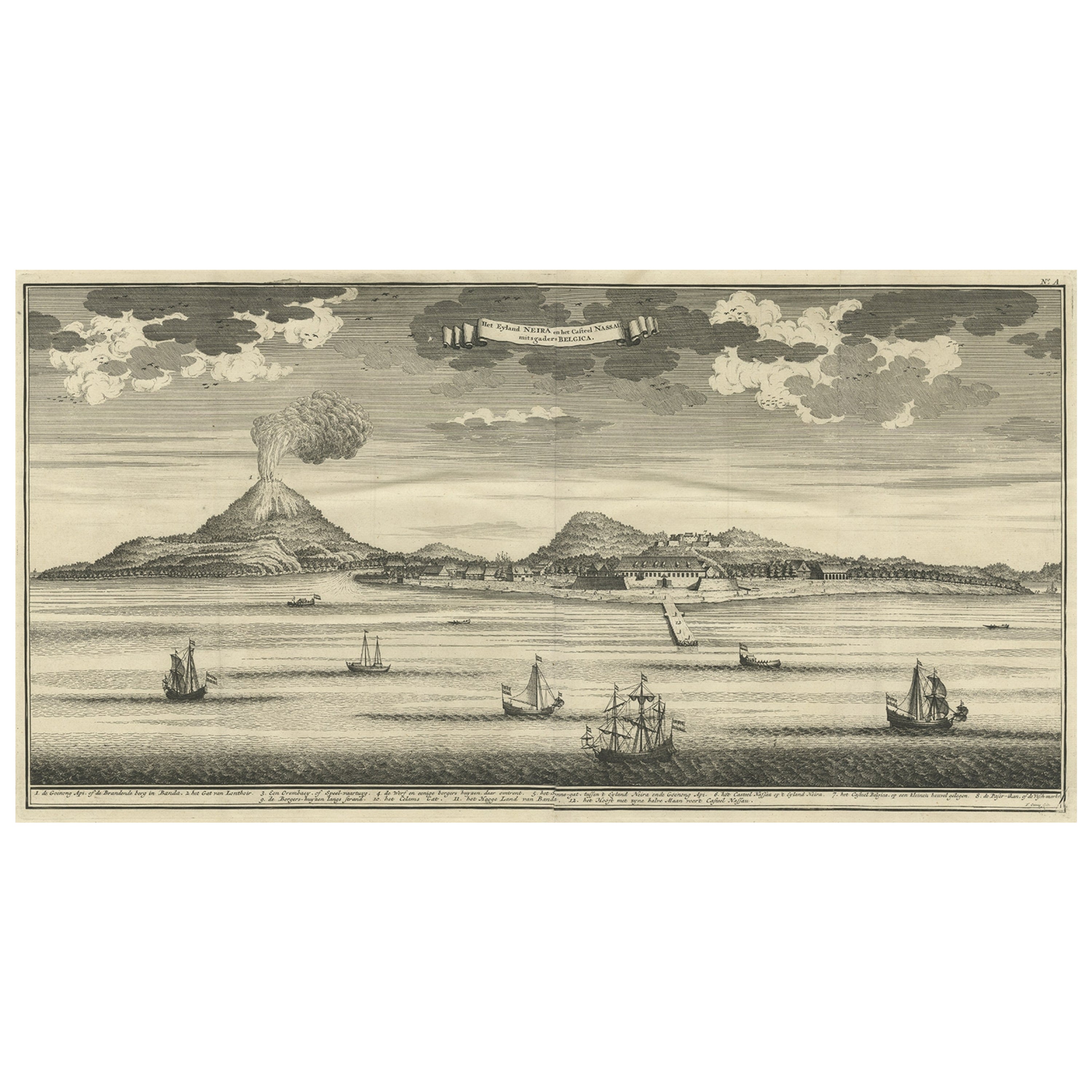
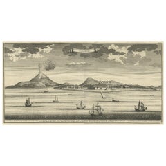
Beautiful Old View of Spice Island Banda Neira with Fort Nassau, Indonesia, 1726
Located in Langweer, NL
Antique print titled 'Het Eyland Neira, en het Casteel Nassau mitsgaders Belgica'.
Beautiful view of Banda Neira with Fort Nassau, Indonesia. This print originates from 'Oud en Nie...
Category
Antique 1720s Maps
Materials
Paper
$910 Sale Price
20% Off
Old Map of the Philippines and Part of Indonesia 'Spice Islands', 1744
Located in Langweer, NL
Antique map titled 'Nieuwe Kaart van de Filippynsche, Ladrones, Moluccos of Specery Eilanden, als mede Celebes etc'.
Old map of the Philippines and part of Indonesia. Originates ...
Category
Antique 1740s Maps
Materials
Paper

$632 Sale Price
20% Off
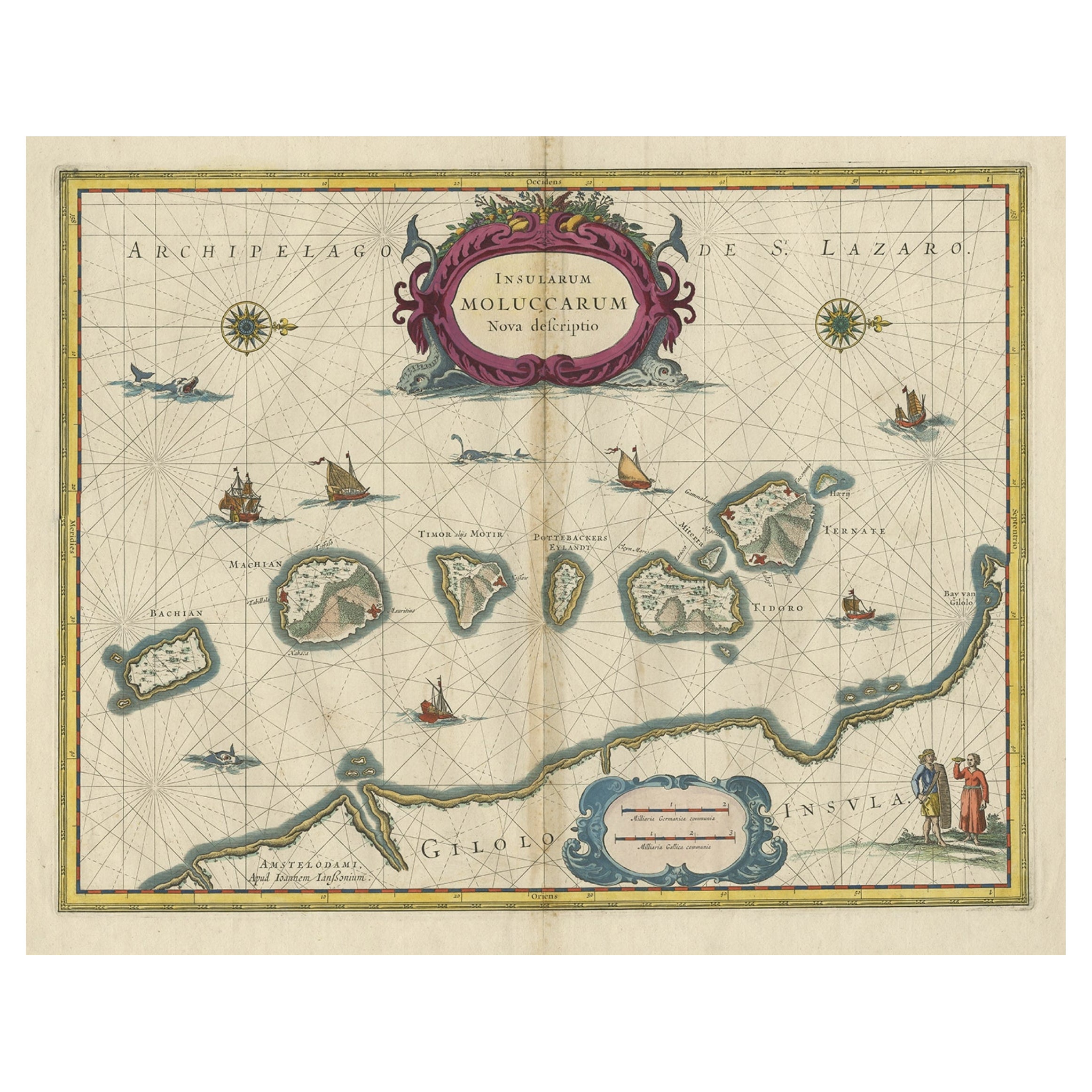
Beautiful Antique Map of the Moluccas or Spice Islands, Indonesia, ca.1650
Located in Langweer, NL
Antique map titled 'Insularum Moluccarum Nova Descriptio.'
Beautiful map of the Moluccas. The famous Spice Islands, the cornerstone of the Dutc...
Category
Antique 1650s Maps
Materials
Paper
$709 Sale Price
20% Off
You May Also Like
Old Horizontal Map of England
By Tasso
Located in Alessandria, Piemonte
ST/520 - Old rare Italian map of England, dated 1826-1827 - by Girolamo Tasso, editor in Venise, for the atlas of M.r Le-Sage.
Category
Antique Early 19th Century Italian Other Prints
Materials
Paper

Hand-Colored 18th Century Homann Map of Denmark and Islands in the Baltic Sea
By Johann Baptist Homann
Located in Alamo, CA
An 18th century copper plate hand-colored map entitled "Insulae Danicae in Mari Balthico Sitae utpote Zeelandia, Fionia, Langelandia, Lalandia, Falstria, Fembria Mona" created by Joh...
Category
Antique Early 18th Century German Maps
Materials
Paper

Map of the Republic of Genoa
Located in New York, NY
Framed antique hand-coloured map of the Republic of Genoa including the duchies of Mantua, Modena, and Parma.
Europe, late 18th century.
Dimension: 25...
Category
Antique Late 18th Century European Maps

Map "Estuary- Mouth of the Thames"
Located in Alessandria, Piemonte
ST/426 - Antique French Map of the estuary of the Thames, map dated 1769 -
"Mape of the entrance of the Thames. Designed by filing of Navy cards fo...
Category
Antique Mid-18th Century French Other Prints
Materials
Paper

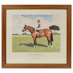
Lithograph Depicting the Horse Winner of the 1990 Italian Derby
Located in Milan, IT
Lithograph on paper made in the 1990s by the Salomone typography in Rome from a painting depicting Houmayoun, winner of the 1990 Italian Derby, ridden by Santiago Soto. With frame 66...
Category
1990s Italian Sports Equipment and Memorabilia
Materials
Wood, Paper
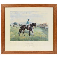
Lithograph Depicting the Horse Winner of the 1987 Italian Derby
Located in Milan, IT
Lithograph on paper made in the 1990s by the Salomone typography in Rome from a painting depicting Zaizoom winner of the 1987 Italian Derby, ridden by J. T Quinn. With frame 66.5x61 ...
Category
1990s Italian Sports Equipment and Memorabilia
Materials
Wood, Paper
More Ways To Browse
Framed Africa Maps
Map Of Israel
Teak Sphere
18th Century Scottish Collectibles
Map Of Mexican California
Ottoman Map
Antique Map Of Korea
Maps South East Asia
Antique Furniture Kansas City
Antique Great Lakes Map
Arnold And Son
Indianapolis Antique Furniture
Antique Map Of Jerusalem
Antique Maps Of Sicily
Antique Celestial Maps
Antique Compass Maritime Compasses
Bengal Map
J C Walker Map