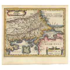
Items Similar to Thraciae Veteris Typus – 1618 Ortelius Map of Ancient Thrace with Hand Color

Want more images or videos?
Request additional images or videos from the seller
1 of 11
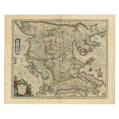
Thraciae Veteris Typus – 1618 Ortelius Map of Ancient Thrace with Hand Color
$1,317.51
£976.35
€1,100
CA$1,798.66
A$2,000.93
CHF 1,048.91
MX$24,450.90
NOK 13,356.61
SEK 12,573.40
DKK 8,375.30
Shipping
Retrieving quote...The 1stDibs Promise:
Authenticity Guarantee,
Money-Back Guarantee,
24-Hour Cancellation
About the Item
Thraciae Veteris Typus – 1618 Ortelius Map of Ancient Thrace with Hand Color
This striking early 17th-century map, Thraciae Veteris Typus, was published in 1618 by Abraham Ortelius as part of Theatrum Orbis Terrarum, the world’s first modern atlas. This map, depicting ancient Thrace, is based on Giacomo Gastaldi’s 1560 map of Southeastern Europe and supplemented with historical information from classical sources, including Herodotus, Pliny, Strabo, Appian, Virgil, Plutarch, and Sidonius.
The map encompasses the northeastern region of Greece and the northwestern part of Turkey, detailing the geography of the ancient Thracian lands. Portions of the Black Sea, the Sea of Marmara, and the Thrakikon Pelagos are depicted, with their waters elegantly stipple-engraved, enhancing the map’s visual appeal. Latin place names reference historical settlements, provinces, and natural landmarks, reflecting both ancient Roman and Greek influences.
This second state of the map includes a correction in the lower right cartouche, where "Gammaides" has been crossed out from the list of places with uncertain locations. The map features three elaborately designed strapwork cartouches, one of which contains an extensive textual description of the Thracian lands. The meticulous engraving, intricate detailing, and hand-applied color bring a dynamic vibrancy to the historical landscape.
As part of Ortelius’ Theatrum Orbis Terrarum, this map represents the Renaissance-era attempt to merge classical knowledge with contemporary cartography. Ortelius, often regarded as the father of modern atlas-making, compiled and refined geographical information from various sources, presenting them in a standardized, decorative format. This map is referenced in Van den Broecke #214, confirming its authenticity and significance.
Condition: Very good. A crisp, well-preserved impression printed on watermarked paper. Minor chips and small tears along the bottom edge are present but do not affect the printed area. The left margin is slightly narrow, while the right margin has been professionally extended, with careful repairs to minor chips and tears in the blank margin.
Framing Advice: For optimal preservation and display, this historical map should be framed using acid-free, museum-quality materials. UV-protective glass or acrylic is recommended to prevent fading of the hand-applied colors. A dark wood or gold-leaf frame will complement the map’s antique aesthetic, while a neutral or parchment-colored mat will enhance its classical appeal. Conservation mounting is advised to ensure the map remains undamaged by adhesives, preserving its value for generations to come.
This beautifully detailed and historically significant map is an essential acquisition for collectors of antique maps, classical history enthusiasts, and those with a passion for the cartographic heritage of Southeastern Europe.
- Dimensions:Height: 14.3 in (36.3 cm)Width: 19.49 in (49.5 cm)Depth: 0.01 in (0.2 mm)
- Materials and Techniques:Paper,Engraved
- Period:1600-1609
- Date of Manufacture:1603
- Condition:Very good. A crisp, well-preserved impression printed on watermarked paper. Minor chips and small tears along the bottom edge are present but do not affect the printed area. The left margin is slightly narrow, the right margin professionally restored.
- Seller Location:Langweer, NL
- Reference Number:Seller: BHZ122341stDibs: LU3054343904052
About the Seller
5.0
Recognized Seller
These prestigious sellers are industry leaders and represent the highest echelon for item quality and design.
Platinum Seller
Premium sellers with a 4.7+ rating and 24-hour response times
Established in 2009
1stDibs seller since 2017
2,494 sales on 1stDibs
Typical response time: 1 hour
- ShippingRetrieving quote...Shipping from: Langweer, Netherlands
- Return Policy
Authenticity Guarantee
In the unlikely event there’s an issue with an item’s authenticity, contact us within 1 year for a full refund. DetailsMoney-Back Guarantee
If your item is not as described, is damaged in transit, or does not arrive, contact us within 7 days for a full refund. Details24-Hour Cancellation
You have a 24-hour grace period in which to reconsider your purchase, with no questions asked.Vetted Professional Sellers
Our world-class sellers must adhere to strict standards for service and quality, maintaining the integrity of our listings.Price-Match Guarantee
If you find that a seller listed the same item for a lower price elsewhere, we’ll match it.Trusted Global Delivery
Our best-in-class carrier network provides specialized shipping options worldwide, including custom delivery.More From This Seller
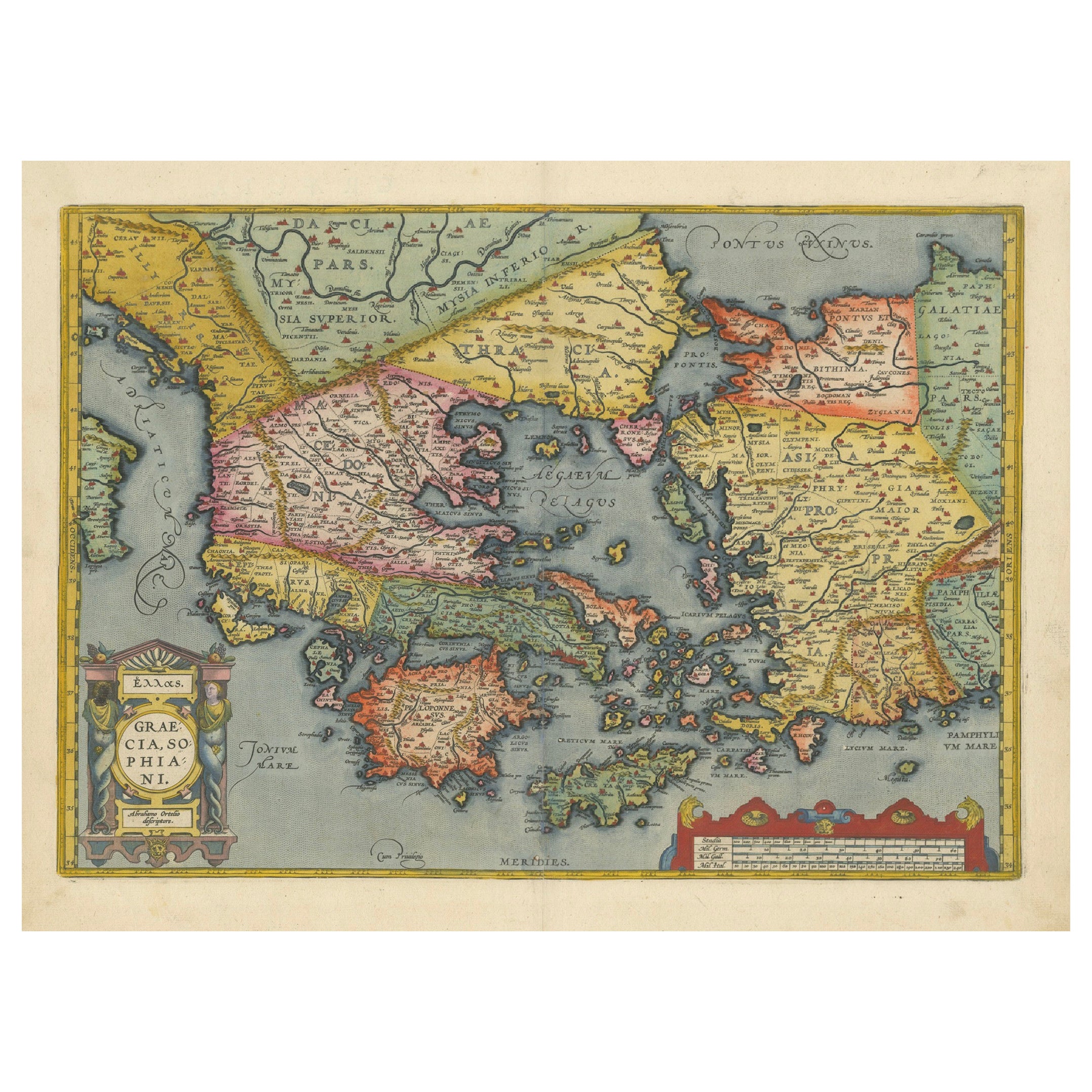
View AllAntique Map of Greece from Ortelius's Theatrum Orbis Terrarum, 1595
Located in Langweer, NL
Original antique map titled "Graecia Sophiani." This is a very detailed and decorative engraved map, with two decorative cartouches and a hand-colored initial on the verso, from Abra...
Category
Antique 16th Century Maps
Materials
Paper
$1,648 Sale Price
20% Off
Free Shipping
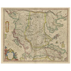
Original Old Map of Northeastern Greece & Northwestern Turkey, Published in 1661
Located in Langweer, NL
This small map was engraved by Petrus Kaerius and is based on Ortelius' map of the same title. It covers the ancient region of Thrace, present-day European Turkey and part of Greece....
Category
Antique 1660s Maps
Materials
Paper
$403 Sale Price
20% Off
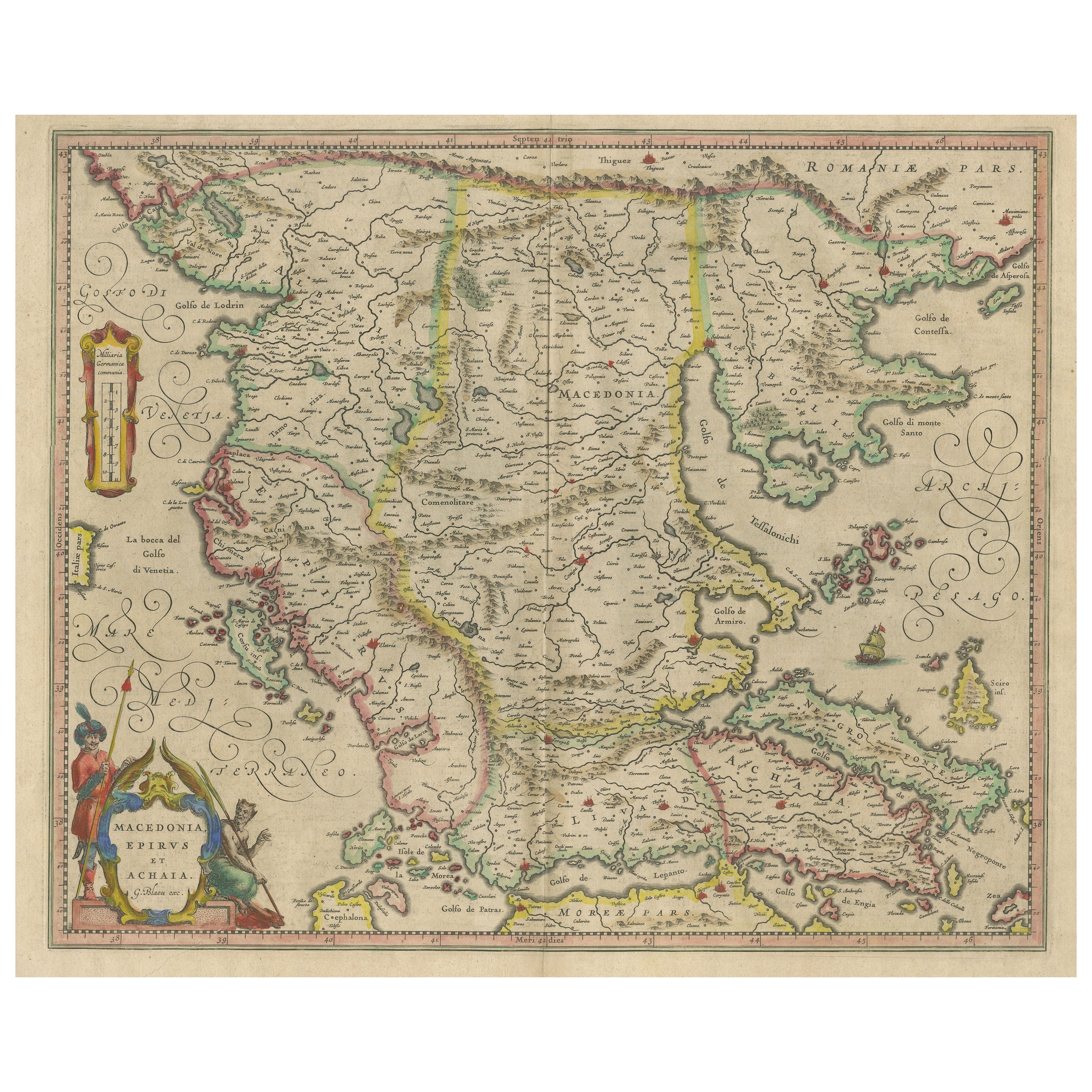
Antique Map of Macedonia, Northern Greece and part of Turkey in Europe
Located in Langweer, NL
Antique map titled 'Macedonia Epirus et Achaia'. Original old map of Macedonia, northern Greece, and part of Turkey in Europe. Published by W.J. Blaeu, circa 1640.
Willem Janszoon ...
Category
Antique Mid-17th Century Maps
Materials
Paper
$766 Sale Price
20% Off
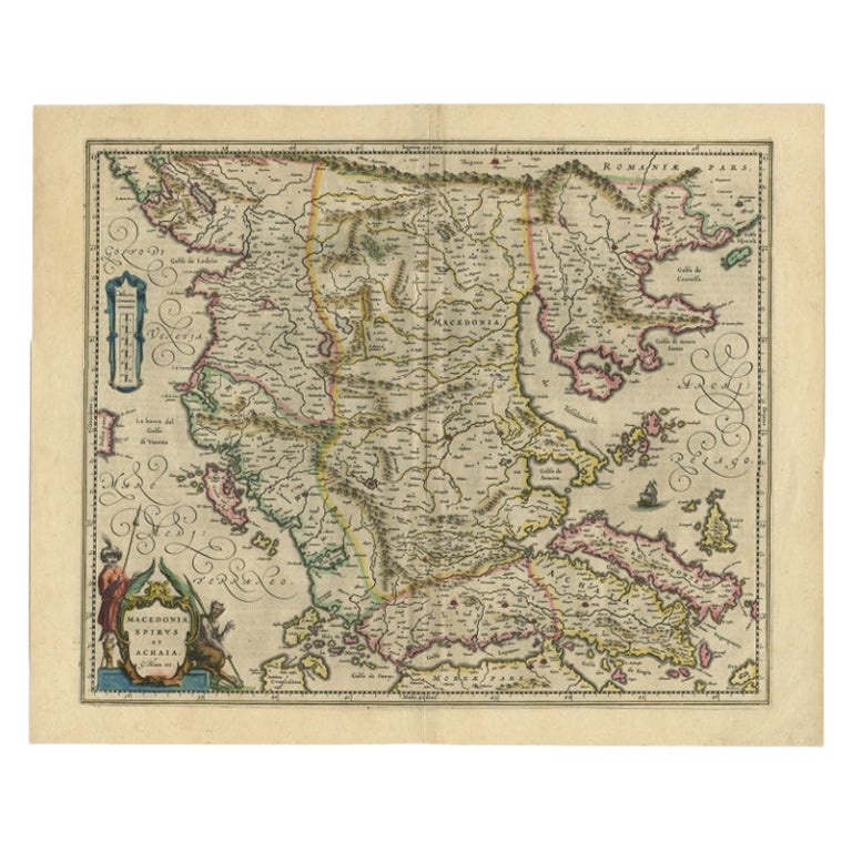
Antique Map of Macedonia by the Famous Mapmaker Blaeu, c.1650
Located in Langweer, NL
Antique map titled 'Macedonia, Epirus et Achaia'.
Ornated with a nice allegoric cartouche, one ship and a milage scale. Macedonia is shown in the centre of the map. With many detai...
Category
Antique 17th Century Maps
Materials
Paper
$1,104 Sale Price
20% Off
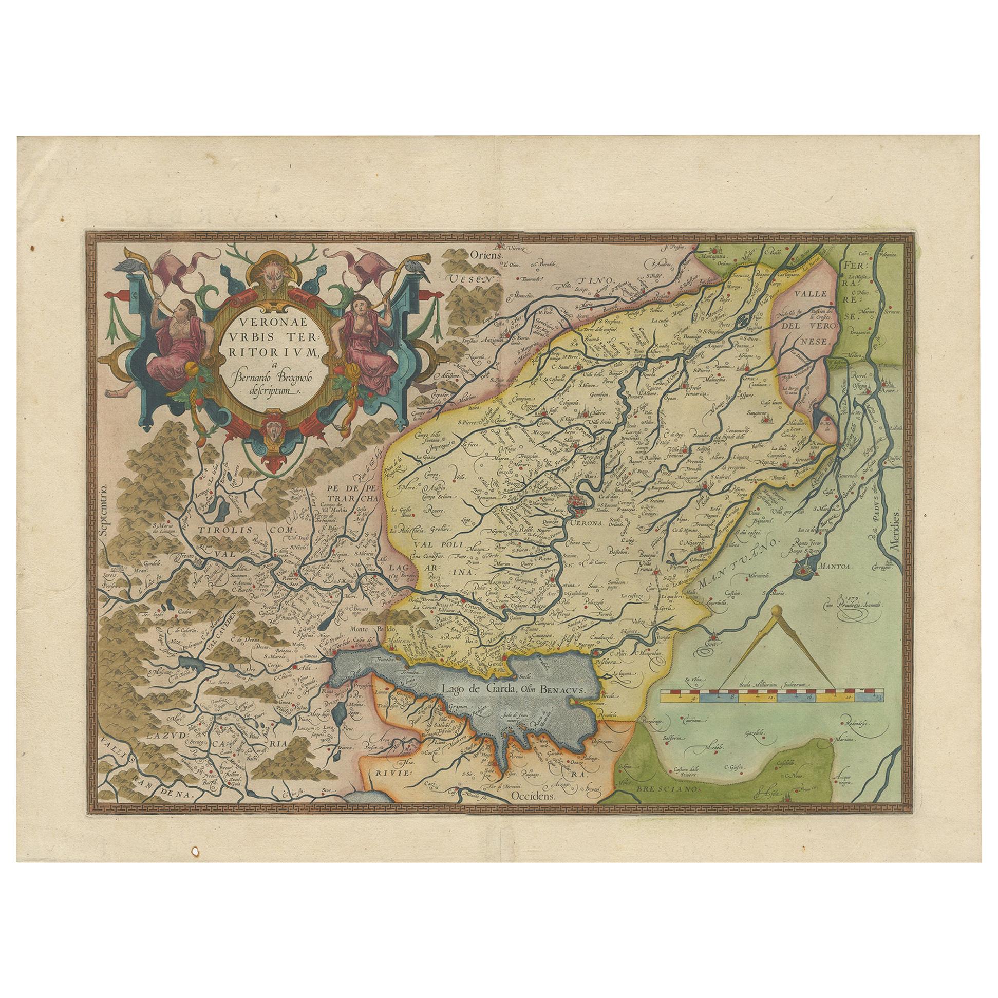
Antique Map of the Region of Verona 'Italy' by Ortelius, circa 1584
Located in Langweer, NL
Antique map titled 'Veronae Urbis Terratorium'. Original antique map of the Verona region, Italy. Centered on Verona, and including Mantua, and Lago de Garda. Published by A. Orteliu...
Category
Antique Late 19th Century Maps
Materials
Paper
$862 Sale Price
20% Off
Original Antique Map of Turkey, Asia Minor and Cyprus
By Gerard Mercator
Located in Langweer, NL
Antique map titled 'Natoliae sive Asia Minor'. Original old map of Turkey, Asia Minor and Cyprus. Includes a decorative cartouches, sailing ship, sea mon...
Category
Antique Early 17th Century Maps
Materials
Paper
$804 Sale Price
20% Off
You May Also Like
Greece, "Graeciae Antiquae"" A 17th Century Hand-colored Map by Sanson
By Nicolas Sanson
Located in Alamo, CA
This is an original 17th century hand colored copperplate engraved map of Greece entitled "Graeciae Antiquae Tabula Hanc Geographicam" by Nicolas d'Abbeville Sanson, engraved and pub...
Category
Antique Mid-17th Century French Maps
Materials
Paper

Southern Greece: A Large 17th C. Hand-colored Map by Sanson and Jaillot
By Nicolas Sanson
Located in Alamo, CA
This large original hand-colored copperplate engraved map of southern Greece and the Pelopponese Peninsula entitled "La Moree Et Les Isles De Zante, Cefalonie, Ste. Marie, Cerigo & C...
Category
Antique 1690s French Maps
Materials
Paper

Greece 1660 Jan Jansson Watercolour Map Peloponesus Sive Morea I Laurenbergio
Located in West Sussex, Pulborough
We are delighted to offer for sale this Jan Jansson Date: 1660 (published) Amsterdam map of Greece.
This is an authentic antique map of Peloponnese or...
Category
Antique 1660s Danish Dutch Colonial Maps
Materials
Copper

"Nova Barbariae Descriptio", a 17th Century Hand-Colored Map of North Africa
By Johannes Janssonius
Located in Alamo, CA
This original attractive 17th century hand-colored map of North Africa entitled "Nova Barbariae Descriptio" by Johannes Janssonius was published in Paris in 1635. It includes the Med...
Category
Antique Mid-17th Century Dutch Maps
Materials
Paper

1562 Map of Toscana Nuova Tavola by Girolamo Ruscelli
Located in Chapel Hill, NC
A 1562 map of Toscana Nuova Tavola by Girolamo Ruscelli. Tuscany is the heart of Italy & birthplace of the Italian language. Early hand-coloring. Copper plate engraving. Interestingl...
Category
Antique 16th Century Italian Renaissance Maps
Materials
Paper
1592 Abraham Ortelius Map "Lorraine: Lotharingiae Nova Descripti, Ric.A005
Located in Norton, MA
1592 Abraham Ortelius map entitled
"Lorraine: Lotharingiae Nova Descripti
Ric.a005
Description: Ortelius is best known for producing the atlas from which this map comes from, "...
Category
Antique 16th Century Dutch Maps
Materials
Paper

More Ways To Browse
Ancient Gold Cross
Ancient Greek Cross
Vintage Scandanavian Chairs
19th Century Red Glass
Antique French Console Table Tables
Silver Bowl Large
Antique French Silk
Down Couch
Used Lighter Art
Blue Edge Glass
Mahogany 1950s Furniture
Solid Mahogany Table
Dessert Glasses
Geometric Glass Table
Mid Century Pin
6x10 Rug
Studded Furniture
Styles Of Antique Desks