Items Similar to Turkey in Asia: Biblical Regions and the Holy Land from The Royal Atlas (1856)
Want more images or videos?
Request additional images or videos from the seller
1 of 10
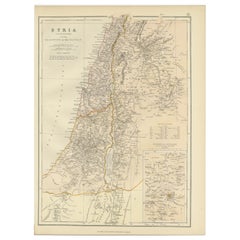
Turkey in Asia: Biblical Regions and the Holy Land from The Royal Atlas (1856)
$632.62
$790.7720% Off
£470.94
£588.6820% Off
€528
€66020% Off
CA$866.53
CA$1,083.1620% Off
A$963.77
A$1,204.7120% Off
CHF 503.25
CHF 629.0620% Off
MX$11,728.08
MX$14,660.0920% Off
NOK 6,427.29
NOK 8,034.1120% Off
SEK 6,027.66
SEK 7,534.5820% Off
DKK 4,019.48
DKK 5,024.3520% Off
Shipping
Retrieving quote...The 1stDibs Promise:
Authenticity Guarantee,
Money-Back Guarantee,
24-Hour Cancellation
About the Item
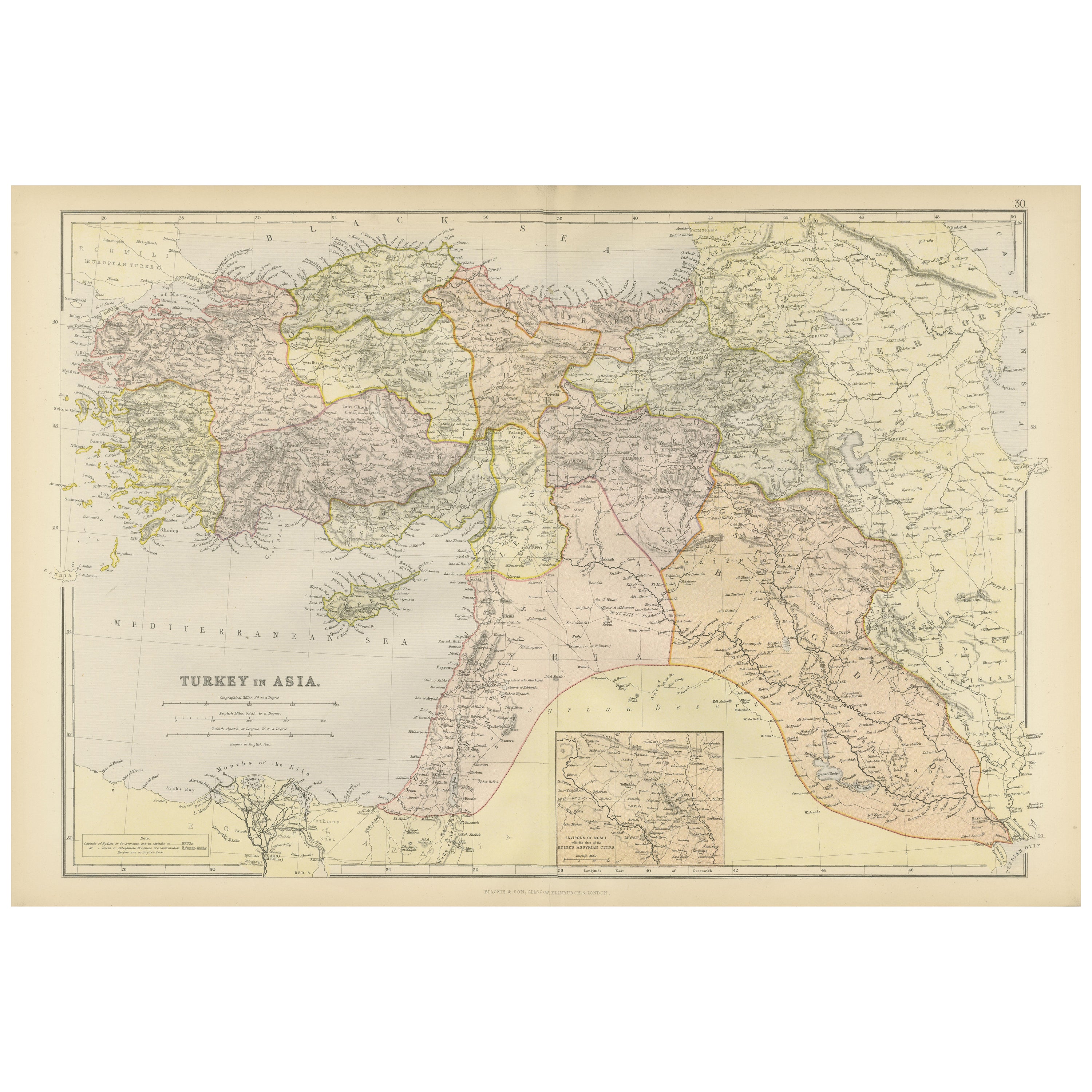
This antique map titled "Turkey in Asia (Biblical Regions) The Holy Land and its Borders" comes from "The Royal Illustrated Atlas", which was published in 1856 by A. Fullarton & Co. The mapmaker, John Bartholomew, was a prominent Scottish cartographer of the 19th century who specialized in both geographical and thematic maps. This map focuses on the Biblical regions of the Holy Land and its borders, including Ancient Phoenicia, The Hauran, and adjacent districts. It provides a detailed representation of the Jewish, Roman, and modern divisions of the land, along with significant topographical features.
The map is presented using lithography, a common mapmaking technique of the time, which allowed for detailed and accurate reproductions. Lithography uses a flat stone or metal plate on which the image is drawn with a greasy substance, enabling mass production of high-quality prints.
This particular map highlights important regions and places relevant to both Biblical and historical contexts. These include:
- Jerusalem, marked as a focal point of religious significance.
- The Dead Sea (Salt Sea), located to the east.
- The Jordan River, running from north to south.
- The territories of ancient tribes such as Judah, Benjamin, Ephraim, Manasseh, and Reuben.
- Phoenicia, located along the Mediterranean coast in the northwest, where cities like Tyre and Sidon are labeled.
- The Land of Edom and Amalekites, south of the Dead Sea.
The map also includes references to Biblical events, with areas divided by the ancient tribal territories of Israel. Additionally, Roman provincial borders and cities are labeled to provide a broader historical context.
This map was created around 1856 and reflects 19th-century European interest in Biblical geography, spurred by religious and archaeological studies of the region. The map served as both a religious and educational tool, showcasing the landscape and political divisions of a historically significant area for European audiences.
- Dimensions:Height: 22.96 in (58.3 cm)Width: 18.63 in (47.3 cm)Depth: 0.02 in (0.5 mm)
- Materials and Techniques:
- Period:
- Date of Manufacture:1856
- Condition:General age-related toning. Original folding line with very small splits in margins. Shows some wear and small defects in margins. Blank verso. Please study image carefully.
- Seller Location:Langweer, NL
- Reference Number:Seller: BG-13449-101stDibs: LU3054338241482
About the Seller
5.0
Recognized Seller
These prestigious sellers are industry leaders and represent the highest echelon for item quality and design.
Platinum Seller
Premium sellers with a 4.7+ rating and 24-hour response times
Established in 2009
1stDibs seller since 2017
2,510 sales on 1stDibs
Typical response time: <1 hour
- ShippingRetrieving quote...Shipping from: Langweer, Netherlands
- Return Policy
Authenticity Guarantee
In the unlikely event there’s an issue with an item’s authenticity, contact us within 1 year for a full refund. DetailsMoney-Back Guarantee
If your item is not as described, is damaged in transit, or does not arrive, contact us within 7 days for a full refund. Details24-Hour Cancellation
You have a 24-hour grace period in which to reconsider your purchase, with no questions asked.Vetted Professional Sellers
Our world-class sellers must adhere to strict standards for service and quality, maintaining the integrity of our listings.Price-Match Guarantee
If you find that a seller listed the same item for a lower price elsewhere, we’ll match it.Trusted Global Delivery
Our best-in-class carrier network provides specialized shipping options worldwide, including custom delivery.More From This Seller
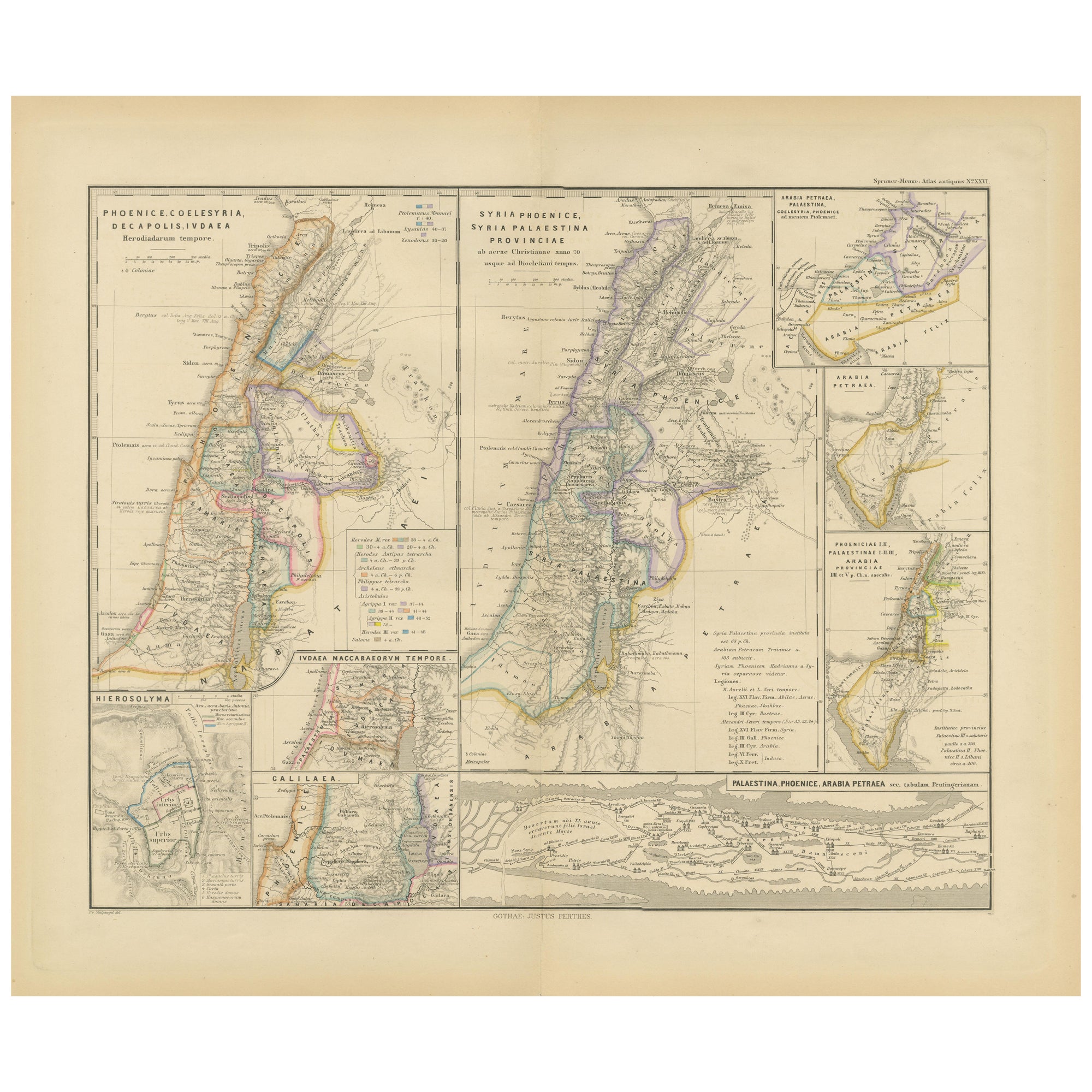
View AllLevant in Antiquity: Lands of Phoenicia, Judea, and Neighboring Kingdoms, 1880
Located in Langweer, NL
The map is titled "PHOENICE, COELESYRIA, IDUMAEA, JUDAEA MACCABAEORUM TEMPORE," which translates to "Phoenicia, Coele-Syria, Idumea, Judea at the Time of the Maccabees."
This origi...
Category
Antique 1880s Maps
Materials
Paper
$354 Sale Price
20% Off
Free Shipping
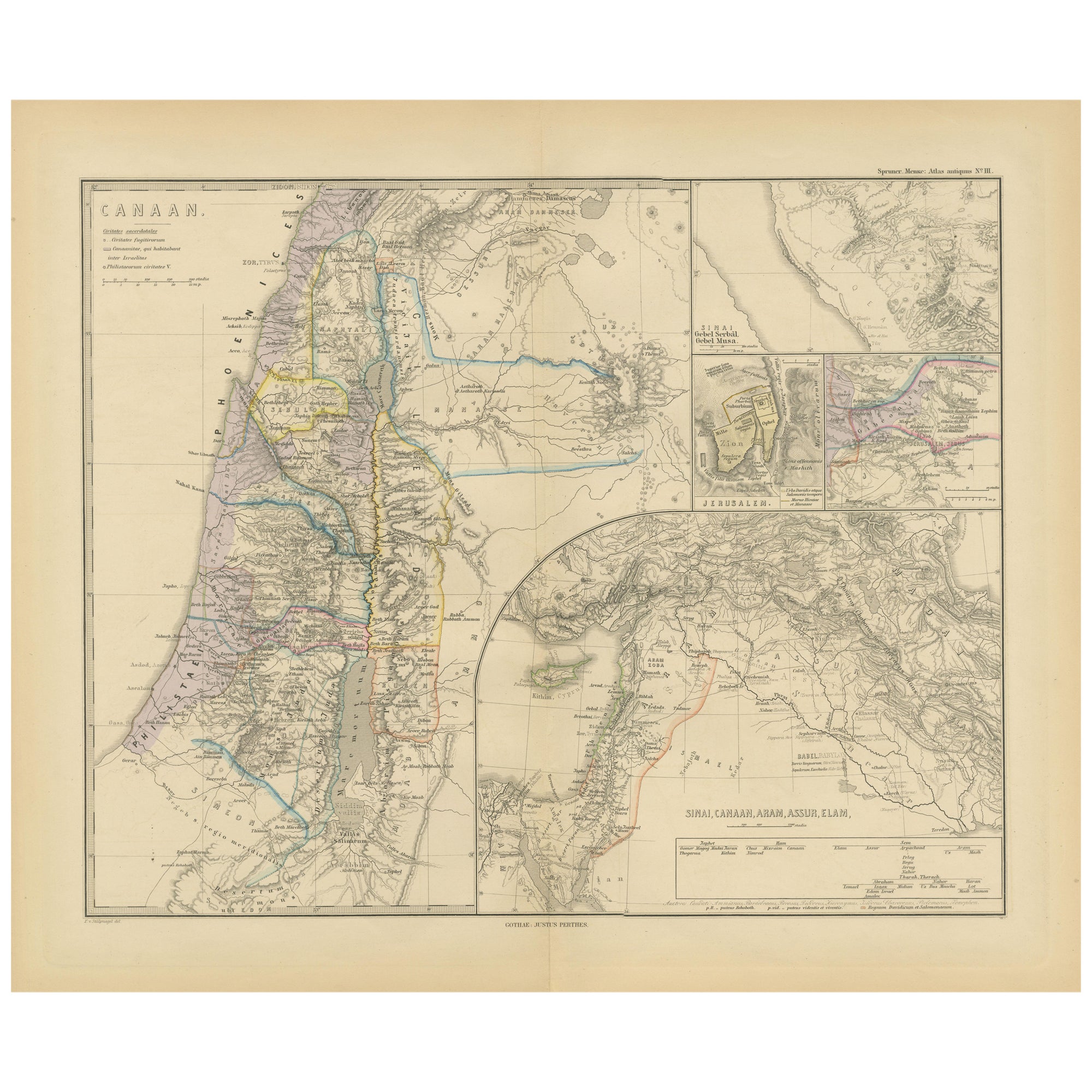
Historical Map of Canaan with Insets of Jerusalem and Surrounding Regions, 1880
Located in Langweer, NL
The map titled "CANAAN" depicts the historical region known as Canaan, located in the Levant, which corresponds to modern-day Israel, Palestinian territories, Lebanon, and parts of S...
Category
Antique 1880s Maps
Materials
Paper
$354 Sale Price
20% Off
Free Shipping
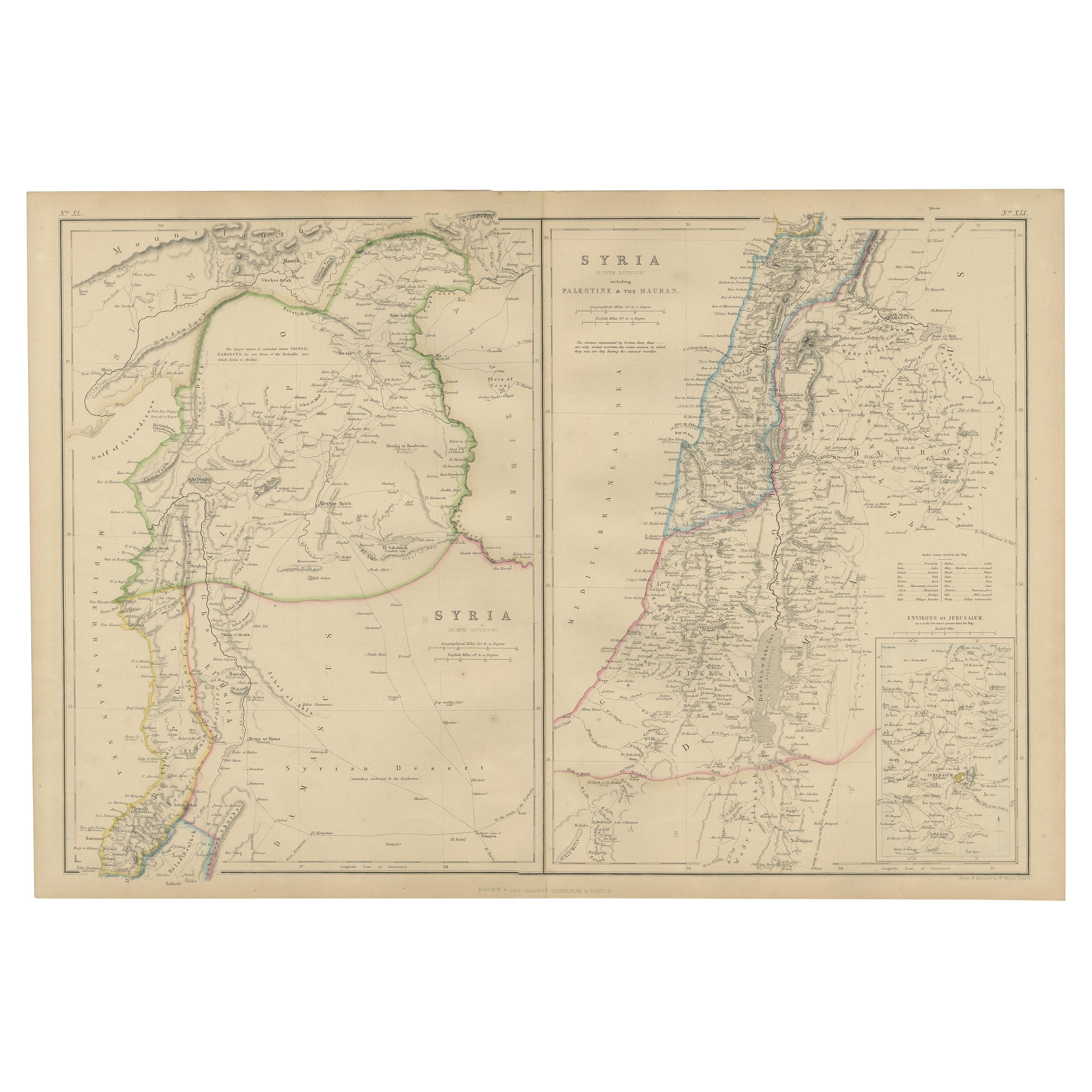
The Divided Realms of Syria - North and South as Seen in 1859 by W. G. Blackie
Located in Langweer, NL
The "Antique Map of Syria, North and South Division" by W. G. Blackie, dated 1859, is a significant historical cartographic work. This map, originating fr...
Category
Antique Mid-19th Century Maps
Materials
Paper

$239 Sale Price
20% Off
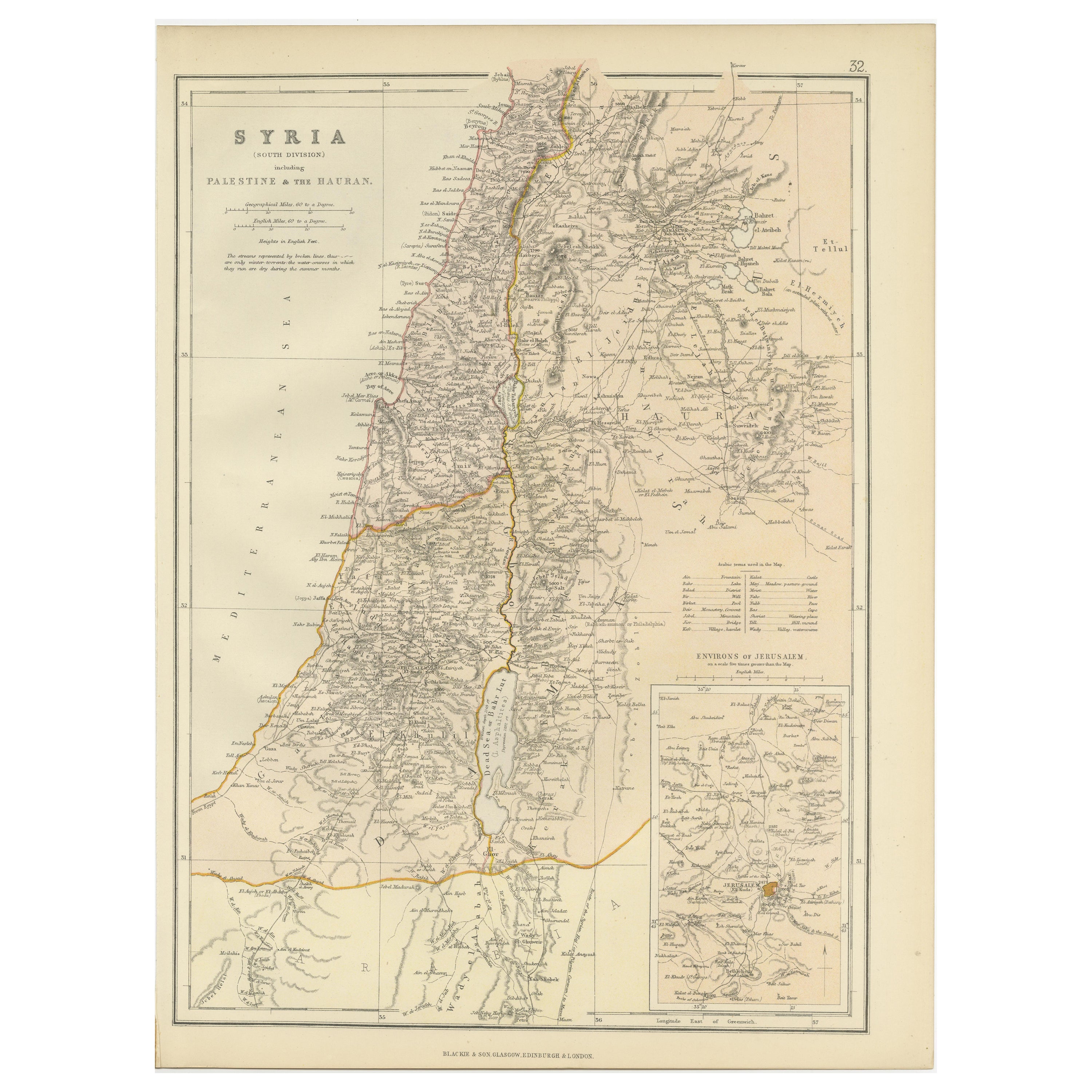
An Insightful 19th Century Map of Syria and the Surrounding Regions, 1882
Located in Langweer, NL
This map, titled "SYRIA (SOUTH DIVISION) including PALESTINE & THE HAUARAN," is a historical cartographic work from the late 19th century, specifically from the 1882 atlas by Blackie...
Category
Antique 1880s Maps
Materials
Paper
$268 Sale Price
20% Off
Empire's Crossroads: An 1882 Map of Turkey in Asia by Blackie & Son
Located in Langweer, NL
This map, titled "Turkey in Asia," is another detailed illustration from the 1882 atlas by Blackie & Son. It showcases the vastness of the Asian territories of the Ottoman Empire, sp...
Category
Antique 1880s Maps
Materials
Paper
$237 Sale Price
40% Off
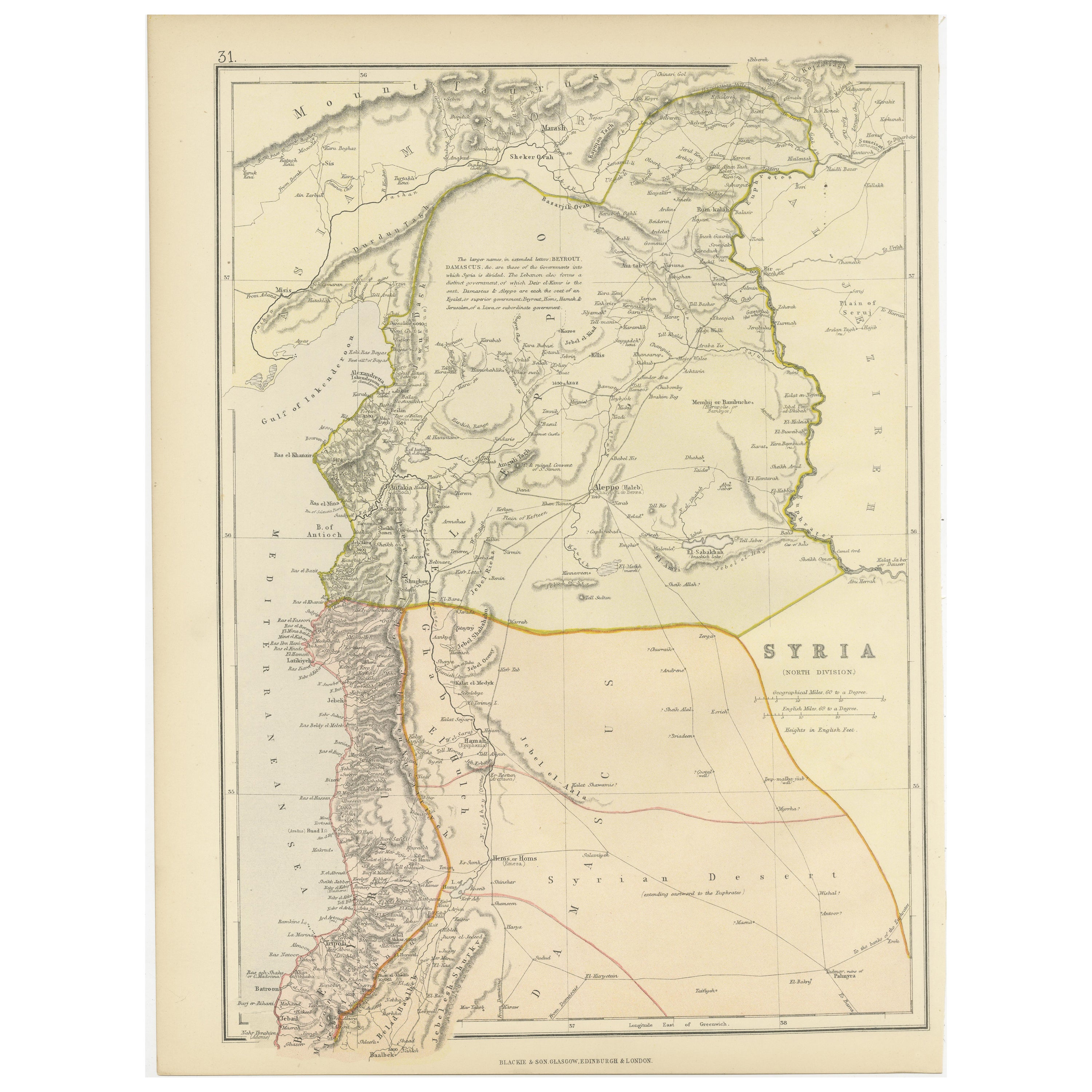
Territories of Antiquity: The Northern Division of Syria, A Detailed 1882 Map
Located in Langweer, NL
This 19th-century map from the atlas published by Blackie and Son in 1882 is titled "SYRIA (NORTH DIVISION)" and covers the northern part of Syria, capturing its geographical and adm...
Category
Antique 1880s Maps
Materials
Paper

$268 Sale Price
20% Off
You May Also Like
Map of the Holy Land "Carte de la Syrie et de l'Egypte" by Pierre M. Lapie
By Pierre M. Lapie
Located in Alamo, CA
An early 19th century map of ancient Syria and Egypt entitled "Carte de la Syrie et de l'Egypte anciennes/dressée par M. Lapie, Colonel d'Etat Major, et...
Category
Antique Early 19th Century French Maps
Materials
Paper

Circa 1825 original engraving of the map of Syria by Giraldon Bovinet
Located in PARIS, FR
The circa 1825 original engraving of "Syrie" by Giraldon Bovinet, based on the work of L. Vivien, is a historically significant map that reflects early 19th-century cartographic tech...
Category
1820s Prints and Multiples
Materials
Engraving, Paper

Large Original Vintage Map of Israel, circa 1920
Located in St Annes, Lancashire
Great map of Israel
Original color.
Good condition
Published by Alexander Gross
Unframed.
Category
Vintage 1920s English Edwardian Maps
Materials
Paper

Original Antique Decorative Map of South America-West Coast, Fullarton, C.1870
Located in St Annes, Lancashire
Great map of Chili, Peru and part of Bolivia
Wonderful figural border
From the celebrated Royal Illustrated Atlas
Lithograph. Original color.
Published by Fullarton, Edi...
Category
Antique 1870s Scottish Maps
Materials
Paper

Map of the Holy Land "Carte de la Syrie et de l'Egypte" by Pierre Lapie
By Pierre M. Lapie
Located in Alamo, CA
This is an early 19th century map of ancient Syria and Egypt entitled "Carte de la Syrie et de l'Egypte anciennes/dressée par M. Lapie, Colonel d'Etat M...
Category
1830s Landscape Prints
Materials
Engraving

1851 Map of "Independent Tartary", Ric. R018
Located in Norton, MA
1851 Map of
Independent Tartary
"Russia"
Ric.r018
A highly decorative 1851 map of Independent Tartary by John Tallis and John Rapkin. Covers the regions between the Caspian Sea and Lake Bakquash and between Russia and Afghanistan. These include the ancient Silk Route kingdoms of Khiva, Tartaria, Kokand, and Bokhara. Today this region roughly includes Kazakhstan, Uzbekistan, Turkmenistan, Kyrgyzstan, and Tajikistan. This wonderful map offers a wealth of detail for anyone with an interest in the Central Asian portion of the ancient Silk Road. Identifies various caravan routes, deserts, wells, and stopping points, including the cities of Bokhara and Samarkand. Three vignettes by W. Bragg decorate the map, these including an image of Tartars on a Journey, a horseback Bride Chase, and a tartar camp site. Surrounded by a vine motif border. Engraved by J. Rapkin for John Tallis's 1851 Illustrated Atlas .
Tartary Antique Map...
Category
Antique 19th Century Unknown Maps
Materials
Paper

More Ways To Browse
Royal Provincial
Antique Turkey Plates
Used Tyre Furniture
Early American Chairs
Hans Muller
Vintage Wood Table With Glass Top
19th Century Square Table
Antonio Bonet
Galle Chairs
Large Chinese Rug
1940s Vintage French Art Deco
20th Century Spanish Table
Antonio Bellini
Retro Fiberglass Furniture
Shipping Crate
Antique Oushak Carpets
Blue Coffee Tables
German Bauhaus Posters