Items Similar to Empire's Crossroads: An 1882 Map of Turkey in Asia by Blackie & Son

Want more images or videos?
Request additional images or videos from the seller
1 of 6
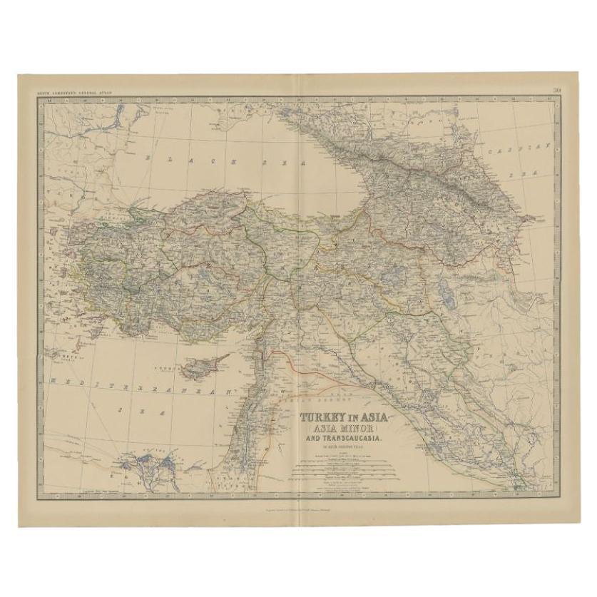
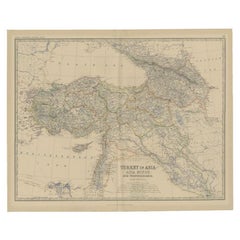
Empire's Crossroads: An 1882 Map of Turkey in Asia by Blackie & Son
About the Item
This map, titled "Turkey in Asia," is another detailed illustration from the 1882 atlas by Blackie & Son. It showcases the vastness of the Asian territories of the Ottoman Empire, spanning from the Mediterranean Sea to the borders of Persia and from the Black Sea down to the Arabian Peninsula.
The map is a rich tapestry of the empire's Asian provinces, delineated with colored borders that neatly define regions such as Anatolia, Mesopotamia, and the Levant. The cartography of the period is evident in the precise rendering of mountain ranges, river systems, and the placement of cities, all vital features for the era's travelers and scholars.
Topographical elements are illustrated with meticulous care, utilizing hachures to show relief and elevation, which was the convention before contour lines became standard. Settlements are marked from the largest cities to the smaller towns, reflecting the density and diversity of the empire's population centers.
In the lower inset, a detailed map of the environs of the Nile showcases the significance of this fertile region. The Nile Delta and the course of the river are clearly depicted, along with important cities like Cairo, underlining the agricultural and economic importance of Egypt to the Ottoman Empire.
This map is a historical document that speaks volumes about the geopolitical landscape of the late 19th century. It would have been an essential reference for understanding the complex makeup of the Ottoman territories in Asia, used by officials, merchants, and explorers alike. It captures a moment in time just before the modern era's dramatic changes and is a testament to the era's cartographic skill and the imperial reach of the Ottoman Empire.
- Dimensions:Height: 14.97 in (38 cm)Width: 22.45 in (57 cm)Depth: 0 in (0.02 mm)
- Materials and Techniques:
- Period:
- Date of Manufacture:1882
- Condition:Good condition, folding line in the middle. The outer borders are slightly discolored due to age, but not the image. This map is ideal for framing. Study the image carefully.
- Seller Location:Langweer, NL
- Reference Number:
About the Seller
5.0
Platinum Seller
These expertly vetted sellers are 1stDibs' most experienced sellers and are rated highest by our customers.
Established in 2009
1stDibs seller since 2017
1,916 sales on 1stDibs
Typical response time: <1 hour
- ShippingRetrieving quote...Ships From: Langweer, Netherlands
- Return PolicyA return for this item may be initiated within 14 days of delivery.
More From This SellerView All
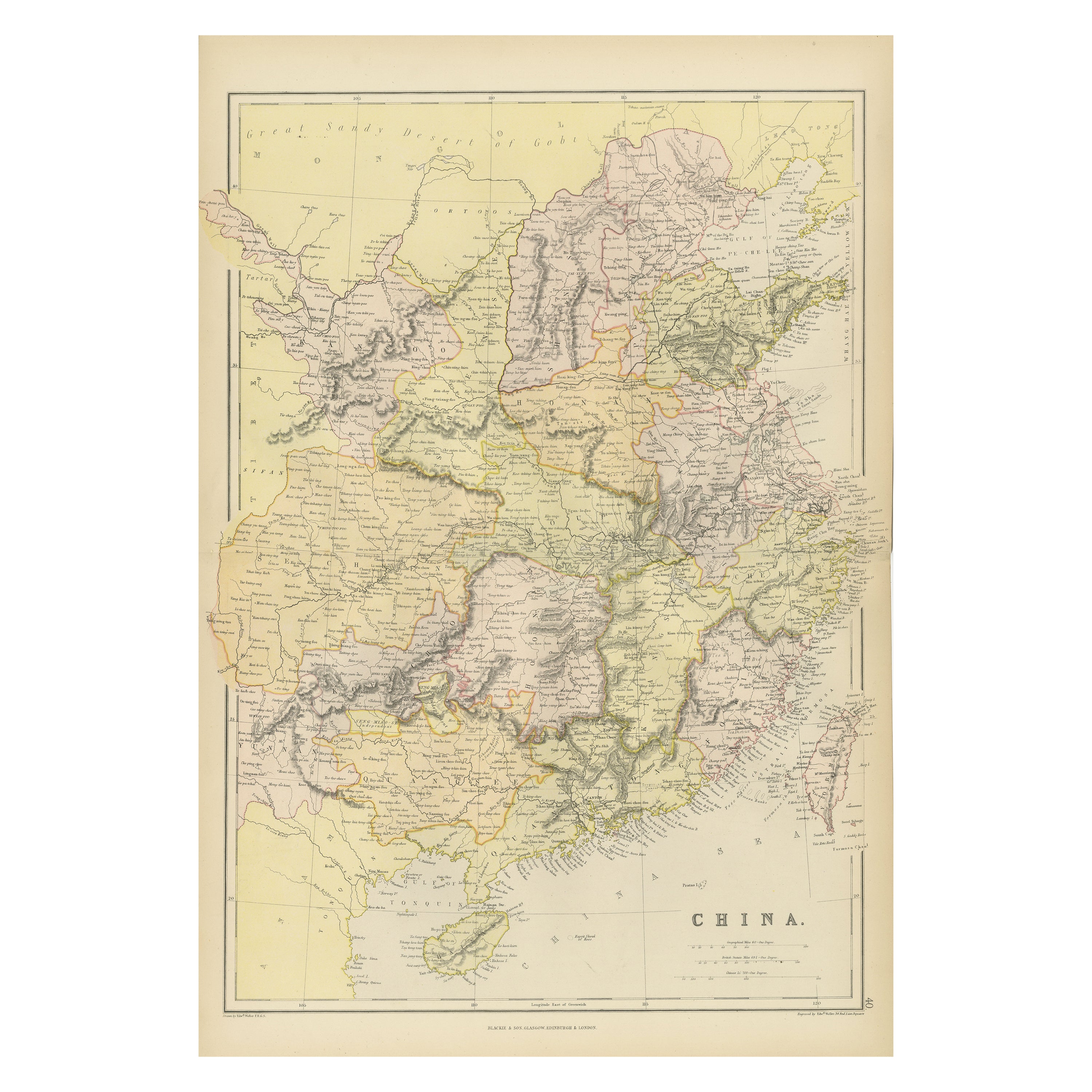
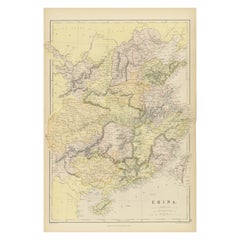
- Antique 19th Century Map of China by Blackie & Son, 1882Located in Langweer, NLThis map is an 1882 Blackie & Son map of China. The title "CHINA." is prominently displayed at the bottom. The map is colored to differentiate various regions, possibly indicating di...Category
Antique 1880s Maps
MaterialsPaper
- Antique Map of Turkey in Asia by Johnston, 1882Located in Langweer, NLAntique map titled 'Turkey in Asia (Asia Minor) and Transcaucasia'. Old map of Turkey in Asia (Asia Minor). This map originates from 'The Royal Atlas of Modern Geography, Exhibiting,...Category
Antique 19th Century Maps
MaterialsPaper
- Antique Map of Asia by with an Inset Map of Turkey in Asia, 1868Located in Langweer, NLAntique map Asia titled 'Carte Politique et Ethnographique d'Asie'. Old map of Asia with an inset map of Turkey in Asia. Includes descriptive text box...Category
Antique 19th Century Maps
MaterialsPaper
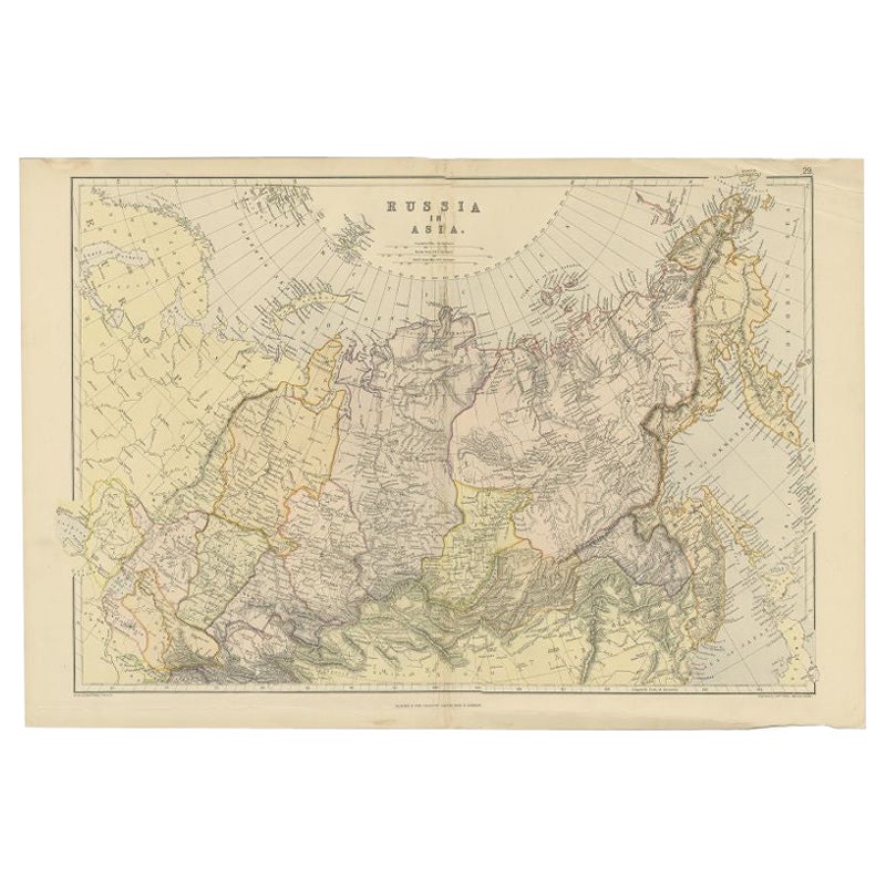
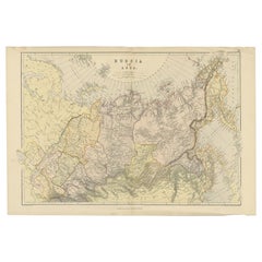
- Antique Map of Russia in Asia by Weller, 1882Located in Langweer, NLAntique map titled 'Russia in Asia'. Old map of Russia originating from Blackie's The Comprehensive Atlas & Geography of the World'. Artists and Engravers: Engraved by E. Weller. Pub...Category
Antique 19th Century Maps
MaterialsPaper
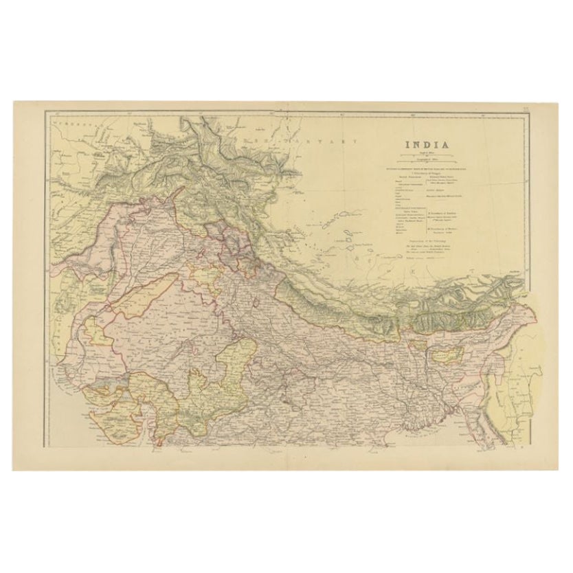
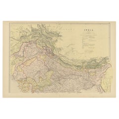
- Antique Map of Northern India by Blackie & Son, 1860Located in Langweer, NLAntique map titled 'India'. Old map depicting northern India. This map originates from 'The Comprehensive Atlas & Geography of the World, Compiled and Engraved from the most Authenti...Category
Antique 19th Century Maps
MaterialsPaper
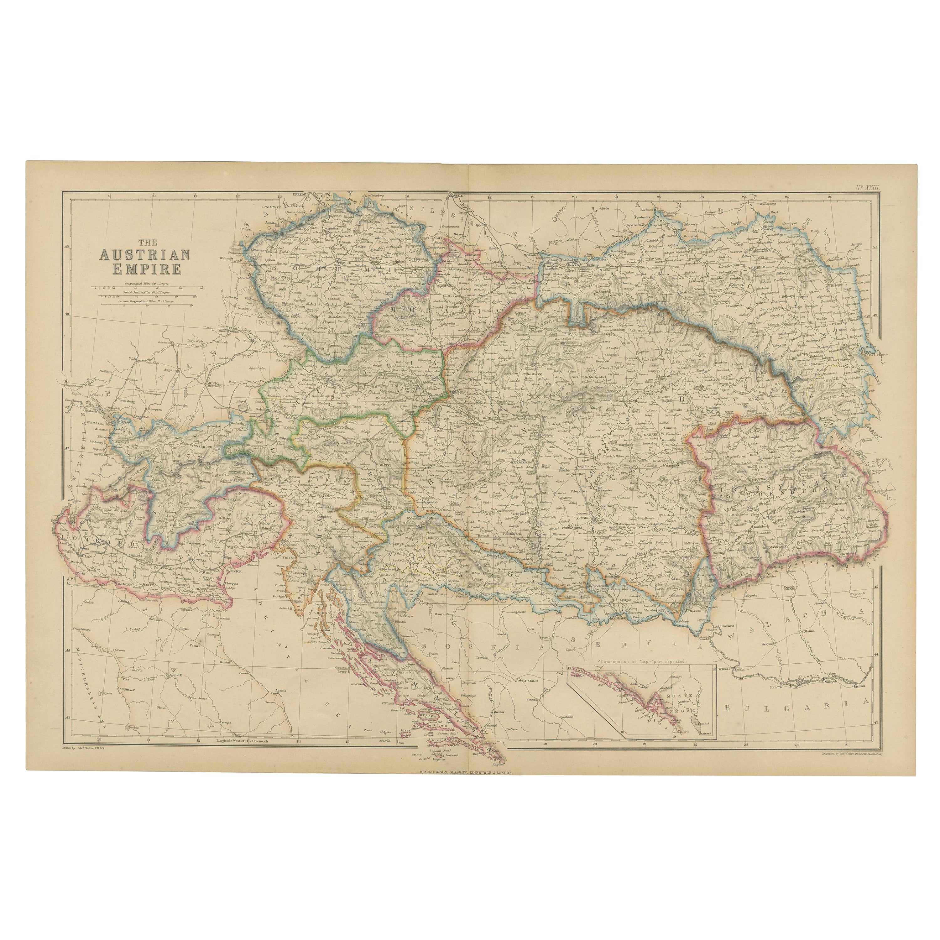
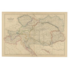
- Antique Map of the Austrian Empire by W. G. Blackie, 1859Located in Langweer, NLAntique map titled 'The Austrian Empire'. Original antique map of the Austrian Empire with inset map of Montenegro. This map originates from ‘The Imperial Atlas of Modern Geography’....Category
Antique Mid-19th Century Maps
MaterialsPaper

You May Also Like
- Original Antique Map of Asia. C.1780Located in St Annes, LancashireGreat map of Asia Copper-plate engraving Published C.1780 Two small worm holes to right side of map Unframed.Category
Antique Early 1800s English Georgian Maps
MaterialsPaper

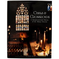
- Canals & Crossroads An illustrated History of Albany, NY Roman Catholic DioceseLocated in valatie, NYCanals & Crossroads: An illustrated History of Albany, New York Roman Catholic Diocese. Albany Catholic Press Association, Incorporated, 1997. Stated fi...Category
1990s American Books
MaterialsPaper
- Antique Carte de L'Inde Myanmar, Malaysia Vietnam Map of Asia the Chinese EmpireLocated in Amsterdam, Noord HollandAntique Carte de L'Inde Myanmar, Malaysia Vietnam Map of Asia the Chinese Empire Very nice map of Asia. Additional information: Type: Map Country of Man...Category
Antique 18th Century European Maps
MaterialsPaper
- Large Original Antique Map of Asia by Sidney Hall, 1847Located in St Annes, LancashireGreat map of Asia Drawn and engraved by Sidney Hall Steel engraving Original colour outline Published by A & C Black. 1847 Unframed Free shippingCategory
Antique 1840s Scottish Maps
MaterialsPaper
- 1814 Map of "Russian Empire" Ric.r032Located in Norton, MA1814 Map of "Russian Empire" Ric.r032 Russian Empire. Description: This is an 1814 John Thomson map of the Russian Empire. The map depicts the region from the Baltic Sea, Prussia, and Sweden to the Aleutian Islands and from the Arctic Ocean to the Yellow River. Highly detailed, myriad cities, towns, and villages are labeled throughout, including St. Petersburg, Moscow, Minsk, Kiev, and Kharkov. Rivers and mountain ranges are also identified, as are islands and numerous locations along the coastlines. It is important to note that the long-disputed sea between Korea and Japan is identified as the 'Sea of Japan. Historical Context: In 1815, Tsarist Russia emerged from the Napoleonic Wars economically insolvent and politically fearful of the Revolutionary fervor that had just swept through Europe. In order to shore up Russia's economic position, the Tsars began an aggressive series of expansions into the Caucuses and Central Asia that would vastly increase the landmass of the Russian Empire. Publication History Thomson maps are known for their stunning color, awe inspiring size, and magnificent detail. Thomson's work, including this map, represents some of the finest cartographic art...Category
Antique 19th Century Unknown Maps
MaterialsPaper
- Hand-Colored 18th Century Homann Map of the Black Sea, Turkey and Asia MinorBy Johann Baptist HomannLocated in Alamo, CAAn attractive original early 18th century hand-colored map of the Black Sea and Turkey entitled "Carte de L'Asie Minevre ou de la Natolie et du Pont Evxin Tiree des Voyages et des Ob...Category
Antique Early 18th Century German Maps
MaterialsPaper


Recently Viewed
View AllMore Ways To Browse
Engraved Cross
Collectors And Curiosities
Minature Map
Anguilla Map
James Calvert Smith
Winkler Prins
A Plan City And Castle Of Batavia
Antique Maine Maps
Shetland Map
Antique Map Iceland
Antique Map Of Iceland
Antique Map Of Maine
Tartar Map
Victor Levasseur On Sale
Antique Curiosities North Carolina
Bolivia Antique Map
Irish Canterbury Furniture
Irish Canterbury