Items Similar to 1632 Decorative Map of the Holy Land, Insets of Jerusalem and Biblical Artefacts


Want more images or videos?
Request additional images or videos from the seller
1 of 10
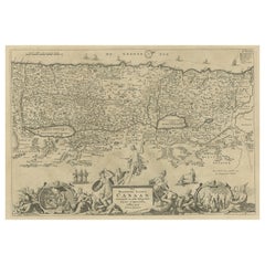
1632 Decorative Map of the Holy Land, Insets of Jerusalem and Biblical Artefacts
$1,533.62
$1,917.0320% Off
£1,141.47
£1,426.8420% Off
€1,280
€1,60020% Off
CA$2,100.68
CA$2,625.8520% Off
A$2,336.42
A$2,920.5220% Off
CHF 1,220
CHF 1,52520% Off
MX$28,431.70
MX$35,539.6220% Off
NOK 15,581.31
NOK 19,476.6420% Off
SEK 14,612.52
SEK 18,265.6520% Off
DKK 9,744.19
DKK 12,180.2420% Off
Shipping
Retrieving quote...The 1stDibs Promise:
Authenticity Guarantee,
Money-Back Guarantee,
24-Hour Cancellation
About the Item
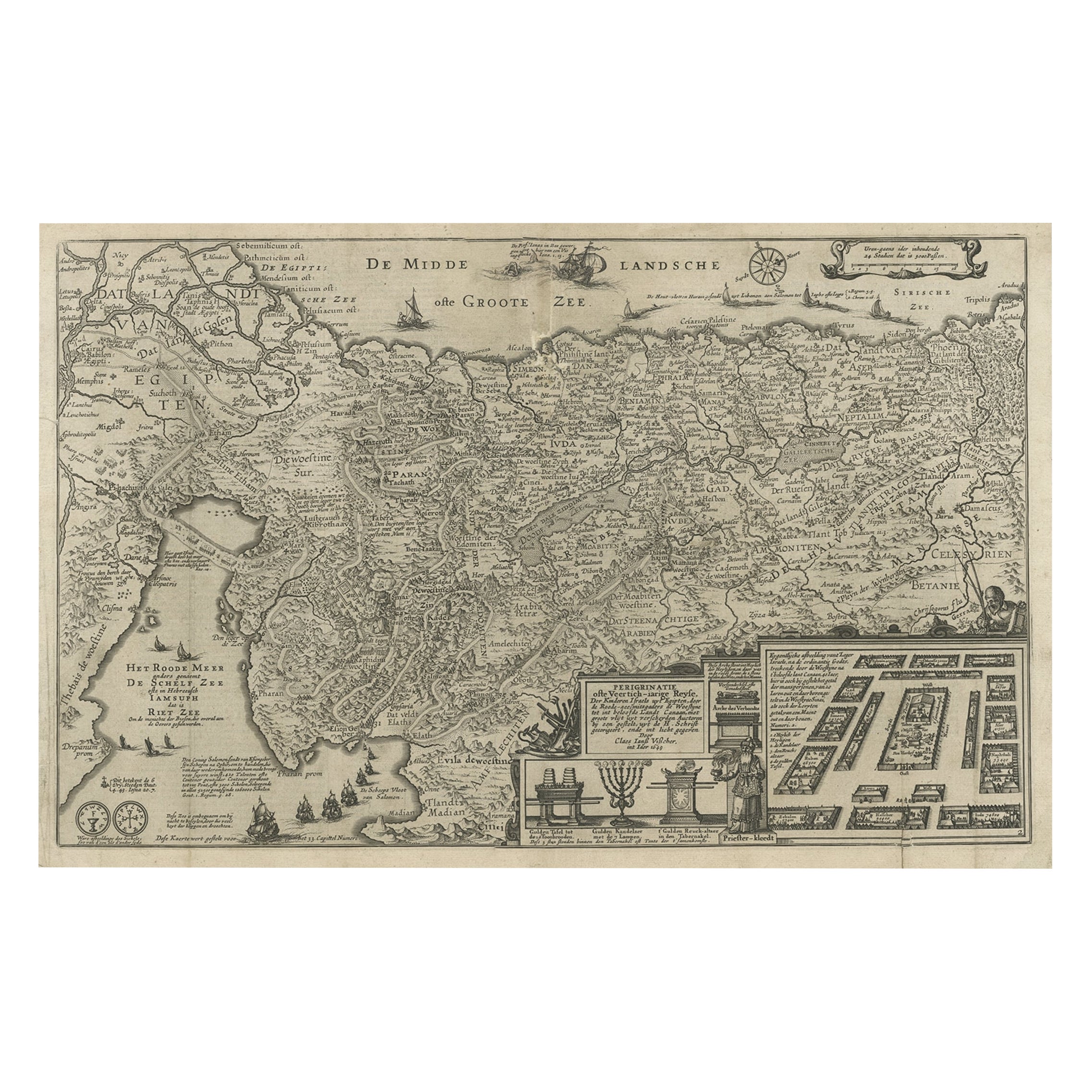
Title: 1632 Decorative Map of the Holy Land with Insets of Jerusalem and Biblical Artefacts
Description: This richly detailed map of the Holy Land, published in 1632, offers a fascinating view of the biblical regions of Israel and surrounding areas. The map, titled "Chorographia Terrae Sanctae," provides a meticulous layout of the Twelve Tribes of Israel, desert areas, and key biblical landmarks. It is embellished with stunning hand-colored illustrations and numerous insets, including a detailed plan of Jerusalem, depictions of Solomon’s Temple, the Tabernacle, and sacred religious artifacts like the Ark of the Covenant and the Menorah.
Alongside its geographic representation, the map includes elaborate allegorical scenes and ships sailing in the Mediterranean, adding both a decorative and historical dimension. Its design reflects the cartographic artistry of the 17th century, blending precision with artistic flair. Produced during the Counter-Reformation, it was intended not only as a geographical reference but also as a visual tool for understanding the biblical narrative and the spiritual significance of the Holy Land.
Engraved using copperplate techniques, the map showcases exceptional craftsmanship, with intricate detailing and vibrant original hand-coloring that brings the historical and biblical scenes to life. It is a rare and valuable artifact, appealing to collectors of historical maps, religious iconography, and 17th-century cartographic works.
Condition: In good condition with vibrant hand-coloring. Top margins a bit brownish on the edge but not touching the image, leaving it perfectly well for framing. No significant tears or repairs but folds as issued and sheets professionally joined together.
Matting and Framing Tips: Use acid-free matting and UV-protective glass to preserve its colors and paper. Pair with a wide, gold-accented frame to enhance its decorative and historical significance. Ensure proper spacing between the glass and the map to prevent damage. Display in a location away from direct sunlight and high humidity to maintain its pristine condition.
- Dimensions:Height: 15.44 in (39.2 cm)Width: 34.14 in (86.7 cm)Depth: 0.01 in (0.2 mm)
- Materials and Techniques:Paper,Engraved
- Period:1630-1639
- Date of Manufacture:1632
- Condition:Condition: In good condition with vibrant hand-coloring. Top margins a bit brownish but not touching the image, leaving it perfectly well for framing. No significant tears or repairs but folds as issued and sheets professionally joined together.
- Seller Location:Langweer, NL
- Reference Number:Seller: BHZ161311stDibs: LU3054343447972
About the Seller
5.0
Recognized Seller
These prestigious sellers are industry leaders and represent the highest echelon for item quality and design.
Platinum Seller
Premium sellers with a 4.7+ rating and 24-hour response times
Established in 2009
1stDibs seller since 2017
2,502 sales on 1stDibs
Typical response time: <1 hour
- ShippingRetrieving quote...Shipping from: Langweer, Netherlands
- Return Policy
Authenticity Guarantee
In the unlikely event there’s an issue with an item’s authenticity, contact us within 1 year for a full refund. DetailsMoney-Back Guarantee
If your item is not as described, is damaged in transit, or does not arrive, contact us within 7 days for a full refund. Details24-Hour Cancellation
You have a 24-hour grace period in which to reconsider your purchase, with no questions asked.Vetted Professional Sellers
Our world-class sellers must adhere to strict standards for service and quality, maintaining the integrity of our listings.Price-Match Guarantee
If you find that a seller listed the same item for a lower price elsewhere, we’ll match it.Trusted Global Delivery
Our best-in-class carrier network provides specialized shipping options worldwide, including custom delivery.More From This Seller
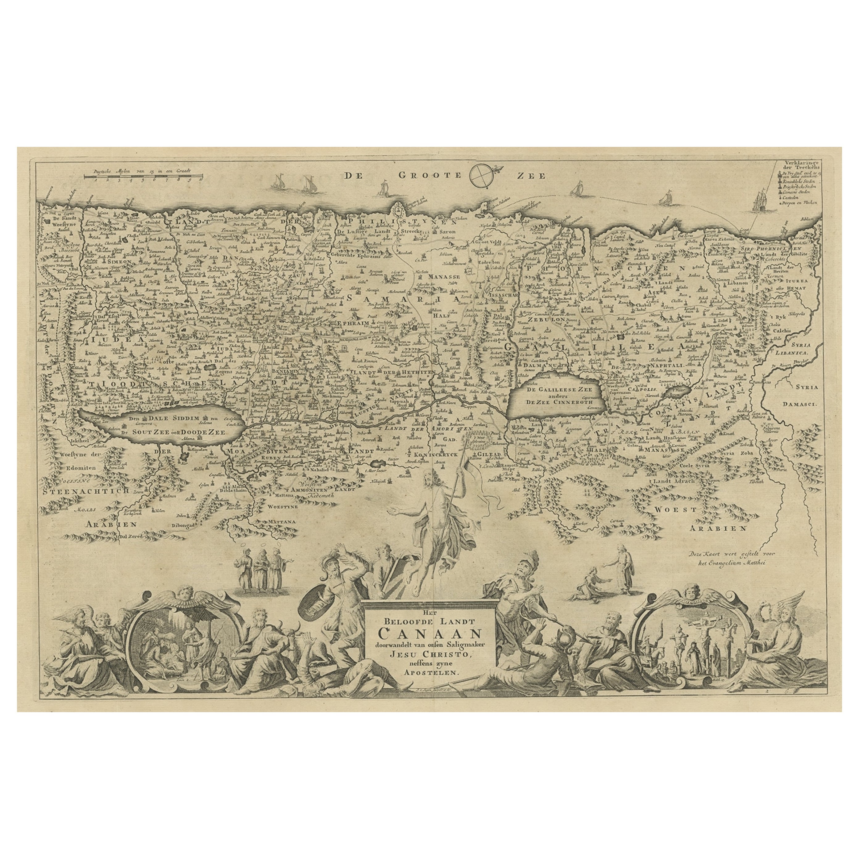
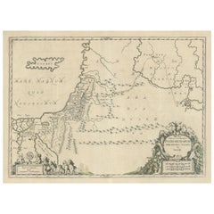
View AllBeautiful Rare Antique Map of the Holy Land, 1648
Located in Langweer, NL
Antique map Holy Land titled 'Perigrinatie ofte Veertich-Iarige Reyse, der kinderen Israels uyt Egipten, door de Roode-Zee; mitsgaders de Woestyne tot int Beloofde Landt Canaan, : met groote vlyt uyt verscheryden auctoren by een gestelt, uyt de H. Schrift gecorigeert, ende int licht gegeven'.
Beautiful and rare antique map of the Holy Land...
Category
Antique 1640s Maps
Materials
Paper
$805 Sale Price
20% Off
Antique Map of the Holy Land Described in the Old and New Testament, ca.1660
Located in Langweer, NL
Antique map titled 'Geographiae Sacrae ex Veteri et Novo Testamento Desumptae Tabula Prima quae Totius Orbis Partes Continet.'
Map of the lands described in the Old and New Testame...
Category
Antique 1660s Maps
Materials
Paper

$814 Sale Price
20% Off
Antique Map of the Holy Land, c.1717
Located in Langweer, NL
Antique map Israel titled 'Tabula Geographica Terrae Sanctae'. Rare edition made after a map of the Holy Land by J. Bonfrerius. The map is oriented ...
Category
Antique 18th Century Maps
Materials
Paper

$373 Sale Price
20% Off
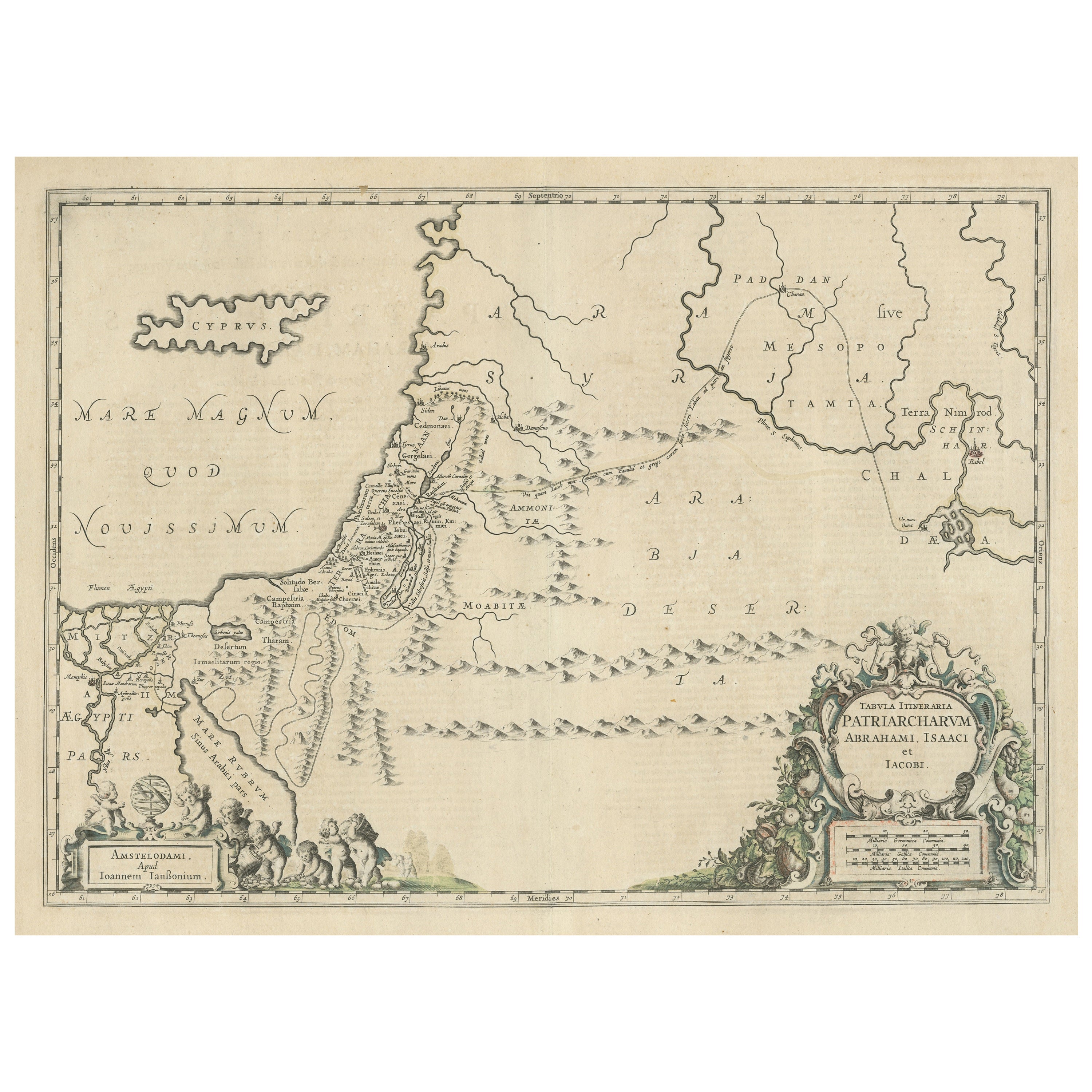
Promised Land of Canaan – Antique Map of Israel with Biblical Scenes, van Jagen
Located in Langweer, NL
Promised Land of Canaan – Antique Map of Israel with Biblical Scenes, van Jagen
This remarkable antique map titled Het beloofde landt Canaan doorwandelt...
Category
Antique 1740s Dutch Maps
Materials
Paper
Antique Map of the Holy Land by Schut, 1710
Located in Langweer, NL
Antique map of the Holy Land titled 'Het Beloofde Landt Canaan.' Very detailed and decorative map of the Holy Land embellished with sailing ships and com...
Category
Antique 18th Century Maps
Materials
Paper

$402 Sale Price
20% Off
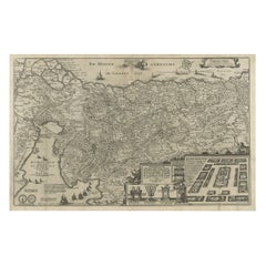
Antique Map of the Holy Land, showing the travels of Abraham, Isaac and Jacob
Located in Langweer, NL
Antique map titled 'Tabula Itineraria Patriarcharum Abrahami, Isaaci et Iacobi'. Decorative regional map of the Holy Land, showing the travels of Abraham, Isaac and Jacob. Published ...
Category
Antique Mid-17th Century Maps
Materials
Paper
$536 Sale Price
20% Off
You May Also Like
Map Holy Land La Terre Sainte Engraved van Loon Published N de Fer 1703 French
Located in BUNGAY, SUFFOLK
La Terre Sainte, The Holy Land, Tiree Des Memoires De M.De.La Rue. Par N. de Fer. Geographe de Sa Majeste Catoliq et de Monseigneur le Dauphin. Avec Privil du Roi 1703
Detailed map of the Holy Land from Nicholas de Fer's L'Atlas Curieux ou le Monde. East is oriented at the top.
MAKER Nicolas de Fer 1646-1720
The French cartographer and engraver, Nicolas de Fer, was a master at creating maps that were works of art. The maps that he published were printed during the Baroque period when the decorative arts were characterized by ornate detail. De Fer’s detailed maps and atlases were valued more for their decorative content than their geographical accuracy.
Nicolas de Fer was born in 1646. His father, Antoine de Fer, owned a mapmaking firm. At the age of twelve, Nicolas was apprenticed to a Parisian engraver named Louis Spirinx. The family business was starting to decline when his father died in 1673. Nicolas de Fer’s mother, Genevieve, took over the business after the death of her husband. In 1687 the business was passed on to Nicolas and the profits increased after he took over the firm. Nicolas de Fer was a prolific cartographer who produced atlases and hundreds of single maps. He eventually became the official geographer to King Louis XIV of France and King Philip V...
Category
Antique Early 1700s French Louis XIV Maps
Materials
Paper

The Holy Land at the Time of Jesus: A 17th Century Dutch Map by Visscher
By Nicolaes Visscher II
Located in Alamo, CA
This detailed Dutch map entitled "Het Beloofe de Landt Canaan door wandelt van onsen Salichmaecker Iesu Christo, nessens syne Apostelen" by Nicolaes Visscher was published in Amsterd...
Category
Antique Mid-17th Century Dutch Maps
Materials
Paper

Antique Map Of Lovanium By Bleau Circa 1640
Located in Brussels, Brussels
map of the brabent of leuven (Belgium) circa 1640 by Bléau. Bléau was well known for antique atlas that he draw during the 17 century
beautiful map, double page folded in the middle,...
Category
Antique 17th Century French Renaissance Prints
Materials
Paper
Rare Original Map of New Amsterdam (New York) – “Restitutio”, ca. 1674 –
Located in Dronten, NL
An exceptionally rare and original 17th-century engraving of New Amsterdam, now New York City, published by the renowned Amsterdam cartographer Carel (Carolus) Allard around 1674. Kn...
Category
Antique 17th Century Dutch Maps
Materials
Paper

Vintage Reproduction 17th Century Map of Europe, American, Cartography, Blaeuw
Located in Hele, Devon, GB
This is a vintage reproduction map of Europe. An American, paper stock cartography print in frame after the work by Blaeuw, dating to the late 20t...
Category
Late 20th Century Central American Mid-Century Modern Maps
Materials
Glass, Wood, Paper

1654 Joan Blaeu Map the Sutherland, Scotland, Entitled "Southerlandia, "Ric0007
Located in Norton, MA
1654 Joan Blaeu map of the
Sutherland, Scotland, entitled
"Southerlandia,"
Hand Colored
Ric0007
Description:
Lovely map centered on Sedan and D...
Category
Antique 17th Century Dutch Maps
Materials
Paper

More Ways To Browse
Jerusalem Furniture
Tabernacle Frame
Qing Dynasty Buddha
Raija Uosikkinen
Rape Of The Sabine
Record Player Cabinet
Rectangular Gallery Tray
Regency Style Bed Frame And Headboard
Retro Hawaiian Rattan Furniture
Rococo Teapot
Roman Stone Fragment
Rope Trimed Table
Rose Ginger Jar
Rosewood Chiffonier
Rosewood Writing Slope
Sabino Opalescent Glass
Sabino Opalescent
Sage Green Cabinet