Items Similar to Unusual Chart Showing Traveling Distances Between European Cities, C.1726


Want more images or videos?
Request additional images or videos from the seller
1 of 5
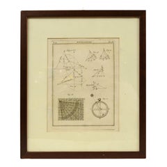
Unusual Chart Showing Traveling Distances Between European Cities, C.1726
$642.76
$803.4520% Off
£478.15
£597.6920% Off
€536
€67020% Off
CA$880.16
CA$1,100.2020% Off
A$978.62
A$1,223.2720% Off
CHF 510.98
CHF 638.7220% Off
MX$11,912.14
MX$14,890.1820% Off
NOK 6,519.87
NOK 8,149.8420% Off
SEK 6,108.81
SEK 7,636.0120% Off
DKK 4,080.27
DKK 5,100.3420% Off
Shipping
Retrieving quote...The 1stDibs Promise:
Authenticity Guarantee,
Money-Back Guarantee,
24-Hour Cancellation
About the Item
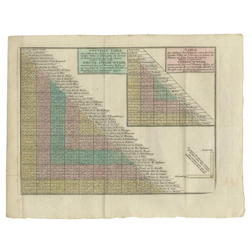
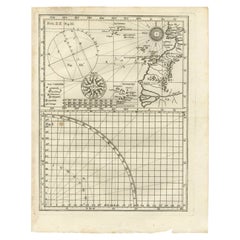
Antique print Europe titled 'Poliometria Europae Maxime Autem Germaniae ac Finitimorum Locorum'.
This unusual chart depicts the traveling distances between various European cities.
Artists and Engravers: Published by R. & I. Ottens, Amsterdam.
Condition: Good, general age-related toning. Original/contemporary hand coloring. Small defect upper margin, please study image carefully.
- Dimensions:Height: 20.87 in (53 cm)Width: 24.02 in (61 cm)Depth: 0 in (0.02 mm)
- Materials and Techniques:
- Period:1720-1729
- Date of Manufacture:circa 1726
- Condition:Wear consistent with age and use. Minor losses. General age-related toning. Original/contemporary hand coloring. Small defect upper margin.
- Seller Location:Langweer, NL
- Reference Number:Seller: BG-11670-81stDibs: LU3054326792872
About the Seller
5.0
Recognized Seller
These prestigious sellers are industry leaders and represent the highest echelon for item quality and design.
Platinum Seller
Premium sellers with a 4.7+ rating and 24-hour response times
Established in 2009
1stDibs seller since 2017
2,511 sales on 1stDibs
Typical response time: <1 hour
- ShippingRetrieving quote...Shipping from: Langweer, Netherlands
- Return Policy
Authenticity Guarantee
In the unlikely event there’s an issue with an item’s authenticity, contact us within 1 year for a full refund. DetailsMoney-Back Guarantee
If your item is not as described, is damaged in transit, or does not arrive, contact us within 7 days for a full refund. Details24-Hour Cancellation
You have a 24-hour grace period in which to reconsider your purchase, with no questions asked.Vetted Professional Sellers
Our world-class sellers must adhere to strict standards for service and quality, maintaining the integrity of our listings.Price-Match Guarantee
If you find that a seller listed the same item for a lower price elsewhere, we’ll match it.Trusted Global Delivery
Our best-in-class carrier network provides specialized shipping options worldwide, including custom delivery.More From This Seller
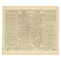
View AllAntique Distance Table Between the Main Cities of Europe by Keizer & De Lat 1788
Located in Langweer, NL
Antique print titled 'Nieuwe Steede-Wyser (..)'. Original antique distance table between the main cities of Europe. This print originates from 'Nieuwe Natuur- Geschied- en Handelkund...
Category
Antique 18th Century Prints
Materials
Paper
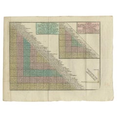
$211 Sale Price
20% Off
Antique Genealogy Chart of Weteravie, Swabia, Westphalia & Franconia, 1732
Located in Langweer, NL
Antique print titled 'Carte de la Seconde Noblesse (..)'. Chart of the noble counts of the second branch of Weteravie, Swabia, Westphalia and Franconia. This print orginates from 'At...
Category
Antique 18th Century Prints
Materials
Paper

$172 Sale Price
20% Off
Rare Antique Map of Part of Europe and Africa by Scherer, C.1703
Located in Langweer, NL
Antique map with two figures. The upper figures showing part of Europe and Africa. Below a chart. Printed for Scherer's 'Atlas Novus' (1702-1710). Artists and Engravers: Heinrich Sch...
Category
Antique 18th Century Maps
Materials
Paper
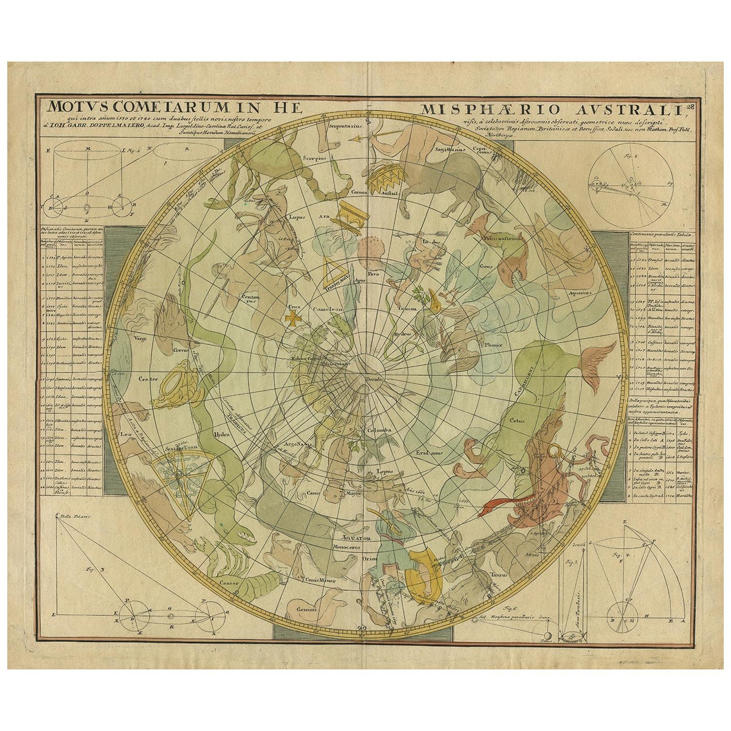
Antique Chart of the Passage of Comets in the Southern Sky, circa 1740
Located in Langweer, NL
Antique map titled 'Motus Comtarum in Hemispaerio Australi (..)'. This uncommon chart depicts the passage of comets in the southern sky between the years 1530-1704. Centered on the ecliptic poles and shows the constellation figures based on classical mythology, without showing the stars. The paths of dozens of comets are illustrated, eincluding those sighted by Tycho Brahe...
Category
Antique Mid-18th Century Maps
Materials
Paper
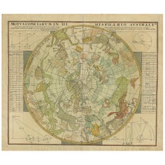
$2,248 Sale Price
25% Off
Antique Map of Europe Stretching from Northern Africa to the Baltic Sea, 1719
Located in Langweer, NL
Antique map titled 'Carte de la Germanie et les diferents Etats ou ses Peuples ont porté leurs conquestes'. Original antique map of Europe stretching from northern Africa to the Balt...
Category
Antique 18th Century Maps
Materials
Paper

$460 Sale Price
20% Off
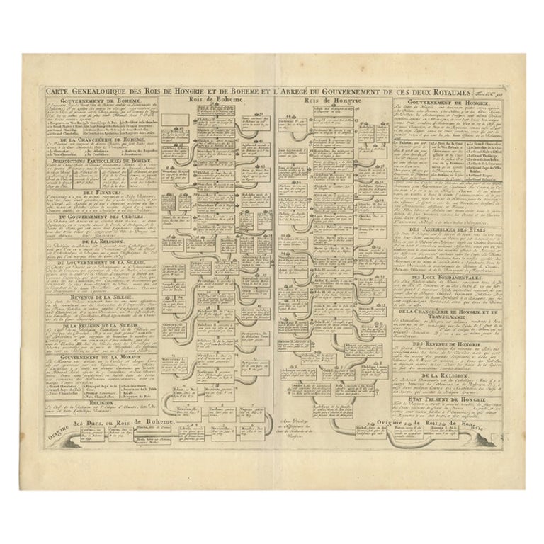
Antique Genealogy Chart of the Kings of Hungary and Bohemia by Chatelain, 1732
Located in Langweer, NL
Antique print titled 'Carte Genealogique des Rois de Hongrie (..)'. Genealogical chart of the kings of Hungary and Bohemia. This print orginates from 'Atlas H...
Category
Antique 18th Century Prints
Materials
Paper
$230 Sale Price
20% Off
You May Also Like
Old Map Depicting the Entire Earth's Surface Divided into Six Parts France 1850
Located in Milan, IT
Map depicting the entire earth's surface divided into six parts which depicts the position of peoples on Earth based on the assumption that it is impossible for each people to have t...
Category
Antique Mid-19th Century French Maps
Materials
Glass, Wood, Paper

The Orbits of Venus and Mercury: An 18th C. Framed Celestial Map by Doppelmayr
By Johann Gabriel Doppelmayr 1
Located in Alamo, CA
This 18th century hand-colored copperplate celestial map by Johann Doppelmayr entitled "Phænomena Motuum Irregularium quos Planetar inferiores Venus et M...
Category
Early 18th Century Landscape Prints
Materials
Engraving
1718 Ides & Witsen Map "Route D'amsterdam a Moscow Et De La Ispahan Et Gamron
Located in Norton, MA
1718 Ides & Witsen map, entitled
"Route D'Amsterdam A Moscow Et De La Ispahan Et Gamron,"
Ric.b005
Subject: Eastern Europe and Central Asia
Period: 1718 (published)
Publicati...
Category
Antique Early 18th Century Dutch Maps
Materials
Paper

1850 Old French Map Depicting the Entire Earth's Surface Divided into Two Parts
Located in Milan, IT
Geographical map depicting the entire earth’s surface divided into two parts that correspond to the two hemispheres or globes, the map deals with the latitudes and longitudes, the me...
Category
Antique Mid-19th Century French Maps
Materials
Glass, Wood, Paper

Engraving on Copper Print from the Volume Navigazione Nautical Subject 1790
Located in Milan, IT
Print by engraving on copper plate Tav III TIX fig. 17-22 from the volume Navigazione; with frame 28 x 33. Some calculations are depicted. Very good condition.
Shipping is insured by...
Category
Antique 1790s Italian Nautical Objects
Materials
Paper
17th Century Hand Colored Map of the Liege Region in Belgium by Visscher
By Nicolaes Visscher II
Located in Alamo, CA
An original 17th century map entitled "Leodiensis Episcopatus in omnes Subjacentes Provincias distincté divisusVisscher, Leodiensis Episcopatus" by Nicolaes Visscher II, published in Amsterdam in 1688. The map is centered on Liege, Belgium, includes the area between Antwerp, Turnhout, Roermond, Cologne, Trier and Dinant.
This attractive map is presented in a cream-colored mat measuring 30" wide x 27.5" high. There is a central fold, as issued. There is minimal spotting in the upper margin and a tiny spot in the right lower margin, which are under the mat. The map is otherwise in excellent condition.
The Visscher family were one of the great cartographic families of the 17th century. Begun by Claes Jansz Visscher...
Category
Antique Late 17th Century Dutch Maps
Materials
Paper

More Ways To Browse
Blue Swedish Chest
Bone Inlay Dresser
Car Wall Sculpture
Carved Oak Bureau
Carved Pig
Cast Iron Anchor
Cast Rabbit
China Bookends
Chinese Curio Cabinet
Chinese Emperor Print
Chinese Guardian Statues
Chinese Headrest
Civil War Memorabillia
Coffee Jar Vintage
Cream Lacquer Chests Of Drawers
Cristal Lalique
Crystal Dolphin
Curio And China Cabinets