Items Similar to North & South America: A 17th Century Hand-colored Map by Jansson & Goos


Want more images or videos?
Request additional images or videos from the seller
1 of 10
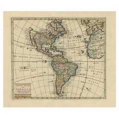
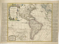
Johannes JanssonNorth & South America: A 17th Century Hand-colored Map by Jansson & Goos1628
1628
$1,275
£973.90
€1,119.12
CA$1,820.07
A$1,995.57
CHF 1,042.07
MX$24,014.12
NOK 13,133.61
SEK 12,348.97
DKK 8,357.77
About the Item
A 17th century hand-colored map of North & South America entitled "Americae Descriptio" by the cartographer Johannes Jansson, published in Jansson's Atlas Minor in Amsterdam in 1628. It was engraved by Abraham Goos. The map is based on an earlier map by Gerardus Mercator. There are many misconceptions about the new world depicted on this fascination map. Among them is the bulging shape of the Northwest coast of North America and the large land mass that extends to Asia, broken only by two small straits. The eastern most strait presumably represents the theorized (and hoped for) Northwest Passage, which was the goal of many explorations maritime for centuries, including the Vikings, Christopher Columbus, Captain James Cook and many more. A navigatable passage through the Americas would facilitate an efficient trade route between Europe and Asia. The map includes portions of Japan, as well as multiple islands in the Atlantic and Pacific Oceans, many of which do not exist. The St. Lawrence River is greatly elongated, extending to the southwest, ending in the region of present-day Colorado. The map also includes the imaginary large land mass in the southern hemisphere, Terra Australis Incognita, the existence of which was not disproved until Captain James Cook's first voyage approximately 150 years later.
This colorful, attractive and fascinating copperplate engraved map is printed on laid, chain-linked hand-made paper with wide margins, particularly the upper and lower margins. There is Latin text on the verso. The sheet measures 7" high and 8.63" wide. There is some discoloration and spotting in the margins and one tiny spot centrally, but the map is otherwise in very good condition.
Jan Jansson or Johannes Janssonius (1588-1664) was born in Arnhem, Holland. His father was a printer and bookseller. In 1612 he married a Hondius daughter and became part of the prominent cartographic and publishing family business. He published his first map on his own in 1616. He partnered with his brother-in-law, the famous cartographer Henricus Hondius. They published their Atlas Major in eleven volumes. He also worked on newer editions of earlier Mercator/Hondius atlases. He published Jansson's English Country Maps in 1646. His brother-in-law continued the business following Jansson's death in 1664.
Abraham Goos (1590-1643) was a Dutch engraver of maps, sea charts, and globes, based initially in Antwerp and later in Amsterdam. The majority of his work was on maps created by Joannes Jansson, Jocodus Hondius, and John Speed.
- Creator:Johannes Jansson (1729 - 1784, Dutch)
- Creation Year:1628
- Dimensions:Height: 7 in (17.78 cm)Width: 8.63 in (21.93 cm)
- Medium:
- Period:1620-1629
- Framing:Framing Options Available
- Condition:
- Gallery Location:Alamo, CA
- Reference Number:Seller: # 13191stDibs: LU117329155752
Johannes Jansson
Jan Jansson or Johannes Janssonius (1588-1664) was born in Arnhem, Holland. His father was a printer and bookseller. In 1612 he married a Hondius daughter and became part of the prominent cartographic and publishing family business. He published his first map on his own in 1616. He partnered with his brother-in-law, the famous cartographer Henricus Hondius. They published their Atlas Major in eleven volumes. He also worked on newer editions of earlier Mercator/Hondius atlases. He published Jansson's English Country Maps in 1646. His brother-in-law continued the business following Jansson's death in 1664. Abraham Goos (1590-1643) was a Dutch engraver of maps, sea charts, and globes, based initially in Antwerp and later in Amsterdam. The majority of his work was on maps created by Joannes Jansson, Jocodus Hondius, and John Speed.
About the Seller
5.0
Platinum Seller
Premium sellers with a 4.7+ rating and 24-hour response times
Established in 2011
1stDibs seller since 2019
293 sales on 1stDibs
Typical response time: 1 hour
- ShippingRetrieving quote...Shipping from: Alamo, CA
- Return Policy
Authenticity Guarantee
In the unlikely event there’s an issue with an item’s authenticity, contact us within 1 year for a full refund. DetailsMoney-Back Guarantee
If your item is not as described, is damaged in transit, or does not arrive, contact us within 7 days for a full refund. Details24-Hour Cancellation
You have a 24-hour grace period in which to reconsider your purchase, with no questions asked.Vetted Professional Sellers
Our world-class sellers must adhere to strict standards for service and quality, maintaining the integrity of our listings.Price-Match Guarantee
If you find that a seller listed the same item for a lower price elsewhere, we’ll match it.Trusted Global Delivery
Our best-in-class carrier network provides specialized shipping options worldwide, including custom delivery.More From This Seller
View AllNorth and South America: An 18th Century Hand-colored Map by Johann Homann
By Johann Baptist Homann
Located in Alamo, CA
This early 18th century hand-colored copperplate map of North and South America entitled "Totius Americae Septentrionalis Et Meridionalis Novissima Repraesentatio" was created by Johann Baptist Homann and published in Nuremberg, Germany, between 1710 and 1731. The map details cities, forts, mountains, forests and lakes, as well as districts. There is a decorative cartouche in the lower left which depicts a volcano, scenes representing the people in their native costumes, as well as animals and plants of the Americas. A village is seen in the background on the left. A second smaller decorative cartouche in the upper right includes text and a series of allegorical figures. A large portion if the north central and western portions of North America is left without detail, because the region was largely unexplored at the time this map was created. The map also shows "Terra Esonis Incognita", representing a mythical continuous land bridge from North America to Asia, a northwest passage. The map preceded the French and...
Category
Early 18th Century Old Masters Landscape Prints
Materials
Engraving

Map of the World: An Original 18th Century Hand-colored Map by E. Bowen
Located in Alamo, CA
This is an original 18th century hand-colored map entitled "A New & Correct Chart of All The Known World Laid down according to Mercator's Projection" by Emanuel Bowen. It was published in 1744 in London in John Harris's "Navigantium atque Itinerantium Bibliotheca" or "A Complete Collection of Voyages and Travels". This highly detailed and colorful map depicts the world. as it was known in the mid 18th century. A majority of the northern and central portions of Canada and America are left blank due to the purity of knowledge at the time this map was published.
The map is embellished with four Compass Roses in the lower left, lower center, lower right and center, along with many rhumb lines. There a is a decorative title cartouche in the upper left. This colorful, attractive, historical and interesting 1744 map presents the entire world on Mercator's projection as it was understood in the middle part of the 18th century, before the landmark explorations of Captain’s Cook, Vancouver, Wilkes and others. It is an example of a nautical chart, a type of map that was designed specifically for use by mariners. The map is centered on the equator and includes both the Eastern and Western Hemispheres. The continents of North America, South America, Europe, Africa, and Asia are depicted, as well as various islands in the Atlantic, Pacific, and Indian Oceans. The map is laid out according to the Mercator projection, a type of cylindrical map projection that was developed in the 16th century by Flemish cartographer Gerardus Mercator. This projection has the advantage of preserving angles and shapes, making it useful for navigation. The map presents a paucity of inland detail, particularly for the Americas, but major cities, geographical landmarks, and regions are included. Ocean currents and Tradewinds are identified, as well as the magnetic declination lines or magnetic variance, which refers to the difference between true north and compass north. The continents are color coded, enhancing the beauty of this map. The three compass roses indicate the directions of the cardinal points.
The depiction of the western coast of America, the Pacific and Australia are interesting. There was very little exploration of Australia between the navigations of William Damper in 1699 and Tobias Furneaux in 1773. Most of the maps detail relies on the 17th century Dutch expeditions to Australia's western coast, by Abel Tasman and William Janszoon. Van Diemen's Land (Tasmania) and New Guinea appear connected to the Australian continent. New Zealand appears as a single landmass. North of New Zealand there is a landmass labelled 'Ter d' St. Esprit' which probably represents the New Hebrides Islands. This map precedes the accurate exploration of the South Pacific and east coast of Australia by Captain James Cook later in the 18th century. The map includes ‘Drakes' Port,' the site where Sir Francis Drake supposedly landed in 1579 during his 1579 circumnavigation of the globe. Here he claimed territory for England, restocked, and repaired his vessels. Drake named the region New Albion. The exact location of Drake's Port is a cartographic mystery. Drake's Harbor is believed to be in the region of San Francisco Bay, Bodega Bay, San Pablo Bay...
Category
Mid-18th Century Old Masters Landscape Prints
Materials
Engraving

Africa: A Large 17th Century Hand-colored Map By Sanson and Jaillot
By Nicholas Sanson d'Abbeville
Located in Alamo, CA
This large original hand-colored copperplate engraved map of Africa entitled "L'Afrique divisee suivant l'estendue de ses principales parties ou sont distingues les uns des autres, L...
Category
1690s Landscape Prints
Materials
Engraving

Map of the East Indies: An Original 18th Century Hand-colored Map by E. Bowen
Located in Alamo, CA
This is an original 18th century hand-colored map entitled "An Accurate Map of the East Indies Exhibiting the Course of the European Trade both on the Continent and Islands" by Emanu...
Category
Mid-18th Century Old Masters Landscape Prints
Materials
Engraving

A Hand Colored 18th Century Framed Map of South America by Thomas Jefferys
Located in Alamo, CA
This detailed hand colored map of South America by Thomas Jefferys was published in London in 1750. The map shows countries, early colonial possessions, towns, rivers, mountains, and...
Category
Mid-18th Century Other Art Style Landscape Prints
Materials
Engraving

"Africa Vetus": A 17th Century Hand-colored Map By Sanson
By Nicholas Sanson d'Abbeville
Located in Alamo, CA
This original hand-colored copperplate engraved map of Africa entitled "Africa Vetus, Nicolai Sanson Christianiss Galliar Regis Geographi" was originally created by Nicholas Sanson d...
Category
1690s Landscape Prints
Materials
Engraving

You May Also Like
Antique Hand-Coloured Map of North and South America, ca.1765
Located in Langweer, NL
Description: Antique map titled 'Nieuwe Kaart van Amerika.' Attractive map of North and South America, the western part of Africa and south west Europe. Source unknown, to be determi...
Category
Antique 1760s Maps
Materials
Paper
$1,185 Sale Price
20% Off
Rare Antique Map of the Americas with Island California by Danckerts, c.1680
Located in Langweer, NL
Rare Antique Map of the Americas with Island California by Justus Danckerts, ca. 1696
This exceptional antique map titled Novissima et Accuratissima Totius Americae Descriptio per I...
Category
Antique Late 17th Century Dutch Maps
Materials
Paper
$3,318 Sale Price
20% Off
Map of South America 1792 by Elwe – Hand-Colored Antique Dutch Engraving
By J.B. Elwe
Located in Langweer, NL
Map of South America 1792 by Elwe – Hand-Colored Antique Dutch Engraving
This striking antique map of South America, titled "L'Amerique Meridionale," was published in 1792 by the Du...
Category
Antique Late 18th Century European Maps
Materials
Paper
Detailed 1795 Map of the Americas with Exploration Tracks and Nice Cartouche
Located in Langweer, NL
This is a very handsome and rare 1795 map of the Americas titled "Amerique ou Nouveau Continent Dressee sur les Nouvelles Relations Decouvertes et Observations" by Jean Baptiste Noli...
Category
Antique 1790s Maps
Materials
Paper
$2,218 Sale Price
20% Off
Antique Map of South American, The West Indies & Most of Africa, Ca.1775
Located in Langweer, NL
Antique map titled 'Carte pour Servir a l' Histoire Philosophique et Politique des Etablissemens et du Commerce des Europeens dans les deux Indes'.
This map is roughly centered o...
Category
Antique 1770s Maps
Materials
Paper

$720 Sale Price
20% Off
Antique Map of South America by Gordon, c.1745
Located in Langweer, NL
Antique map titled 'South America according to the latest observations'. Antique map of South America originating from 'Geography Anatomiz'd: or, The Geographical Grammar'. Artists a...
Category
Antique 18th Century English Maps
Materials
Paper
More Ways To Browse
Antique Hand Chain
Northwest Coast
Antique Maps Of North America
World Map Of Trade Routes
Mercator Map
Christopher James
Antique Maps Colorado
1950 Fashion Illustrations
Antique Poster Food
Arman Resin
Baroque Painting Angel
Botanical Print Rose
Bronze Hippo
Charles Cary Rumsey
Club 57
Colleen Browning
Communist Propaganda Poster
Crazy Watch