Items Similar to Albacete, Spain - 1902: A Cartographic Depiction of Landscape and Infrastructure


Want more images or videos?
Request additional images or videos from the seller
1 of 6
Albacete, Spain - 1902: A Cartographic Depiction of Landscape and Infrastructure
$273.44
$341.8020% Off
£205.96
£257.4420% Off
€232
€29020% Off
CA$377.09
CA$471.3620% Off
A$423.64
A$529.5520% Off
CHF 221.35
CHF 276.6920% Off
MX$5,170.72
MX$6,463.4020% Off
NOK 2,810.53
NOK 3,513.1620% Off
SEK 2,645.52
SEK 3,306.9020% Off
DKK 1,765.90
DKK 2,207.3720% Off
About the Item
Albacete, Spain - 1902: A Cartographic Depiction of Landscape and Infrastructure
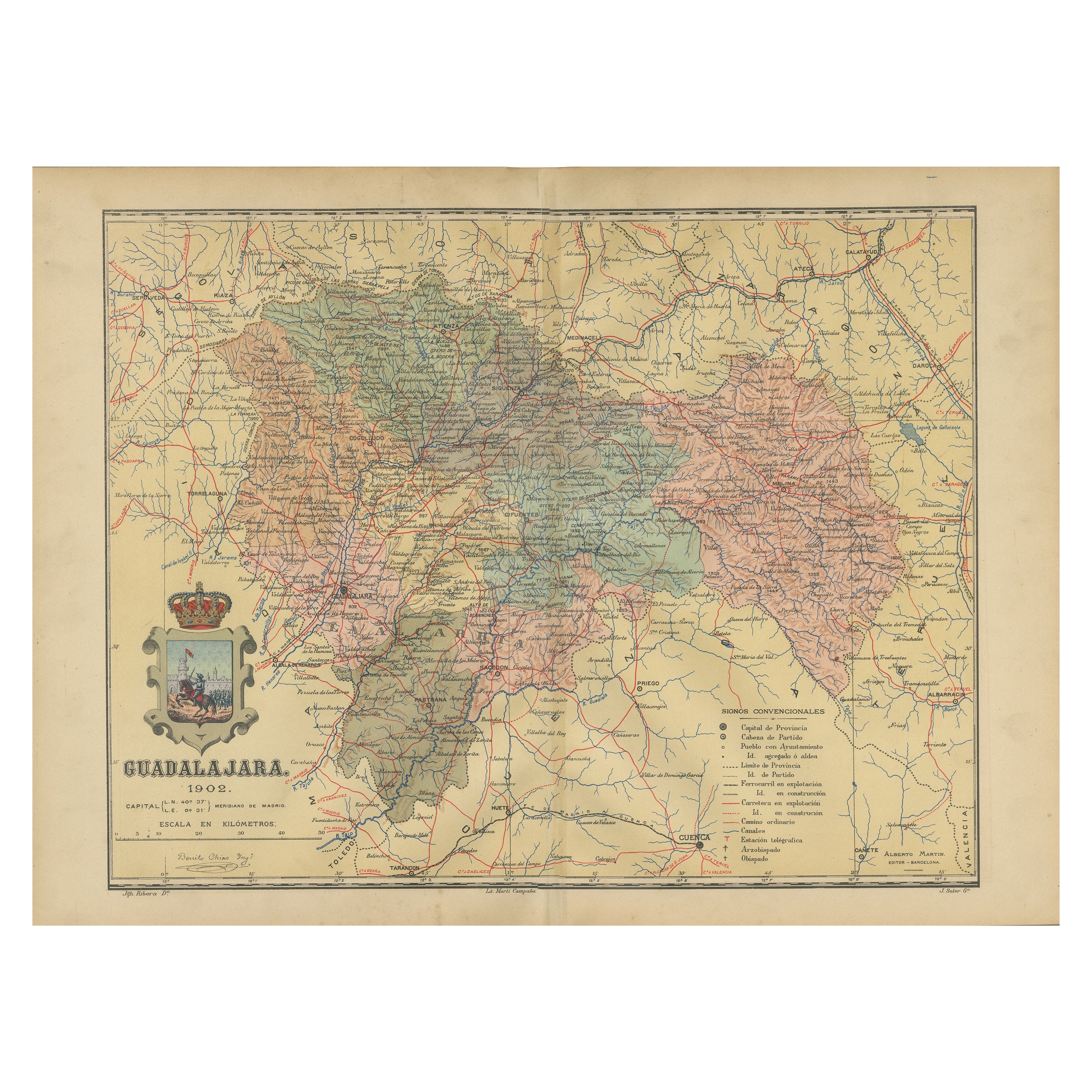
An original and historical map of the province of Albacete, dated 1902, from the "Atlas Geográfico Ibero-Americano España" by D. Benito Chias y Carbo.
Albacete is a province in the southeastern part of the Castilla-La Mancha region in Spain. It is known for several key features and historical elements:
The province has a varied landscape, including parts of the plains of La Mancha to the north and mountainous areas to the south. It also encompasses parts of the Iberian plateau.
The capital city, also named Albacete, is a significant urban center in the region and has been historically important as a hub for the manufacturing of knives and other bladed tools.
Traditionally, the economy of Albacete has been based on agriculture and the production of wine and cheese. In recent times, the services sector and industrial development have grown, diversifying the provincial economy.
Albacete is known for its rich cultural heritage, including traditional festivals like the Feria de Albacete, which is declared of International Tourist Interest by Spain, and features bullfighting, music, and regional cuisine.
There are notable archaeological sites in the province, including prehistoric rock paintings in the municipality of Hellín, which are part of the Rock Art of the Mediterranean Basin on the Iberian Peninsula, a UNESCO World Heritage site.
It contains important natural parks and reserves, such as the Lagunas de Ruidera and the Calares del Mundo y de la Sima Natural Parks, which are significant for their biodiversity and geological formations.
Albacete is the site of the Los Llanos Air Base, which has been used by the Spanish Air Force and has hosted NATO training operations.
The province also hosts an international motorcycle racing circuit known as Circuito de Albacete, which is popular for various motor racing events.
Albacete serves as a transportation hub, with significant road and rail networks connecting it to major cities like Madrid and Valencia.
The province combines a mix of traditional rural life with modern development, and its history spans from ancient times through the Roman and Moorish periods to the present day, with each era leaving its mark on the culture and architecture of the region.
- Dimensions:Height: 14.77 in (37.5 cm)Width: 20.08 in (51 cm)Depth: 0 in (0.02 mm)
- Materials and Techniques:
- Period:1900-1909
- Date of Manufacture:1902
- Condition:Good condition. Central vertical folding lines as issued. Light brown discoloring in the fold line. Aged paper with typically warm, yellowish-brown hue, especially around the edges.
- Seller Location:Langweer, NL
- Reference Number:Seller: BG-13642-21stDibs: LU3054338031332
About the Seller
5.0
Recognized Seller
These prestigious sellers are industry leaders and represent the highest echelon for item quality and design.
Platinum Seller
Premium sellers with a 4.7+ rating and 24-hour response times
Established in 2009
1stDibs seller since 2017
2,533 sales on 1stDibs
Typical response time: <1 hour
- ShippingRetrieving quote...Shipping from: Langweer, Netherlands
- Return Policy
Authenticity Guarantee
In the unlikely event there’s an issue with an item’s authenticity, contact us within 1 year for a full refund. DetailsMoney-Back Guarantee
If your item is not as described, is damaged in transit, or does not arrive, contact us within 7 days for a full refund. Details24-Hour Cancellation
You have a 24-hour grace period in which to reconsider your purchase, with no questions asked.Vetted Professional Sellers
Our world-class sellers must adhere to strict standards for service and quality, maintaining the integrity of our listings.Price-Match Guarantee
If you find that a seller listed the same item for a lower price elsewhere, we’ll match it.Trusted Global Delivery
Our best-in-class carrier network provides specialized shipping options worldwide, including custom delivery.More From This Seller
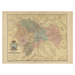
View AllGuadalajara 1902: A Cartographic Image of Castilla-La Mancha's Northern Province
Located in Langweer, NL
The map illustrates the province of Guadalajara, part of the autonomous community of Castilla-La Mancha in Spain, as of 1902. The map includes various geographic and infrastructural ...
Category
Antique Early 1900s Maps
Materials
Paper
$273 Sale Price
20% Off
Free Shipping
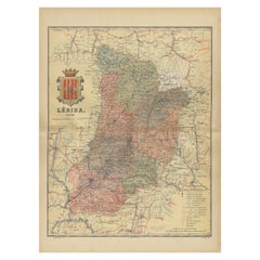
Lleida 1902: A Cartographic Perspective of Catalonia's Gateway to the Pyrenees
Located in Langweer, NL
The map for sale shows the province of Lleida, located in the western part of Catalonia, Spain, as of 1902. Here are the key features depicted on the map:
- **Topography**: The map ...
Category
Antique Early 1900s Maps
Materials
Paper
$282 Sale Price
20% Off
Free Shipping
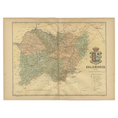
1902 Cartographic View of Salamanca: The Golden Province of Spain
Located in Langweer, NL
This map showcases the province of Salamanca in the year 1902. Salamanca is located in the autonomous community of Castile and León in western Spain. It is bordered by the provinces ...
Category
Antique Early 1900s Maps
Materials
Paper
$260 Sale Price
35% Off
Free Shipping
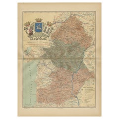
Antique Map of Alentejo: Land of Tradition and Tranquility, 1903
Located in Langweer, NL
The image is a historical original antique map of the Alentejo region in Portugal. This map includes the topographical layout of the region, with its complex network of roads and wat...
Category
Antique Early 1900s Maps
Materials
Paper
Topographical and Infrastructure Map of the Province of Valencia, 1901
Located in Langweer, NL
A historical map of the province of Valencia, dated 1901. The map includes intricate details such as topographical features, with mountain ranges and river systems prominently marked...
Category
Antique Early 1900s Maps
Materials
Paper

$490 Sale Price
20% Off
Free Shipping
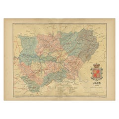
Jaén 1902: A Cartographic Depiction of Andalusia's Olive Heartland
Located in Langweer, NL
This original antique map displays the province of Jaén, located in the autonomous community of Andalusia in southern Spain, as of the year 1902. It contains various geographic and i...
Category
Antique Early 1900s Maps
Materials
Paper
$273 Sale Price
20% Off
Free Shipping
You May Also Like
Large Original Vintage Map of Spain, circa 1920
Located in St Annes, Lancashire
Great map of Spain
Original color.
Good condition
Published by Alexander Gross
Unframed.
Category
Vintage 1920s English Maps
Materials
Paper

1594 Maurice Bouguereau Map of the Region Limoges, France, Ric0015
Located in Norton, MA
1594 Maurice Bouguereau map of the region Limoges, France, entitled
"Totivs Lemovici et Confinium Pro Uinciarum Quantum ad Dioecefin Lemo Uicenfen Fpectant,"
Hand Colored
Ric0015
Jean IV Le Clerc...
Category
Antique 16th Century Dutch Maps
Materials
Paper

Map of Spain and Portugal - Original Etching - Late 19th Century
Located in Roma, IT
This Map of Spain and Portugal is an etching realized by an anonymous artist.
The state of preservation of the artwork is good with some small diffused stains.
Sheet dimension: 28...
Category
Late 19th Century Modern Figurative Prints
Materials
Etching

Original Antique English County Map, Nottinghamshire, J & C Walker, 1851
Located in St Annes, Lancashire
Great map of Nottinghamshire
Original colour
By J & C Walker
Published by Longman, Rees, Orme, Brown & Co. 1851
Unframed.
Category
Antique 1850s English Other Maps
Materials
Paper

Ancient National Atlas of France with Marengo
Located in Alessandria, Piemonte
Ancient National Atlas of France with the department of Marengo: a rare French etching dated 1806.
ST/178.
Category
Antique Early 19th Century French Other Prints
Materials
Paper

Original Antique Map or City Plan of Madrid, Spain. Circa 1835
Located in St Annes, Lancashire
Nice map of Madrid
Drawn and engraved by J.Dower
Published by Orr & Smith. C.1835
Unframed.
Free shipping
Category
Antique 1830s English Maps
Materials
Paper

More Ways To Browse
Spanish Provincial
Antique Oushak
Mid Century Danish Directors Chairs
Moller 70
Argentina Travel Poster
Century Furniture Faux Bamboo
Early American Chairs
Hans Muller
Vintage Wood Table With Glass Top
19th Century Square Table
Antonio Bonet
Galle Chairs
Large Chinese Rug
1940s Vintage French Art Deco
20th Century Spanish Table
Antonio Bellini
Retro Fiberglass Furniture
Shipping Crate