Items Similar to Jaén 1902: A Cartographic Depiction of Andalusia's Olive Heartland


Want more images or videos?
Request additional images or videos from the seller
1 of 6
Jaén 1902: A Cartographic Depiction of Andalusia's Olive Heartland
About the Item
This original antique map displays the province of Jaén, located in the autonomous community of Andalusia in southern Spain, as of the year 1902. It contains various geographic and infrastructural features:
It illustrates the mountainous regions such as the Sierra Morena in the north and the Sierra de Cazorla in the east, with contour lines showing elevation changes. Blue lines represent rivers, likely including the Guadalquivir, which runs through the province. Red lines indicate roads and railways, depicting the infrastructure that connects Jaén's towns and cities both internally and with surrounding regions. Symbols mark the locations of cities, towns, and villages, with the capital city, also named Jaén, highlighted.
The coat of arms of Jaén is prominently featured, reflecting the historical significance of the region with symbols such as the castle and the lion.
About the province of Jaén:
Jaén is known as the world's leading producer of olive oil, which is a fundamental part of the local economy and culture. The landscape is dotted with extensive olive groves, and the province is often referred to as the "sea of olives." Jaén's rich history is reflected in its many Renaissance towns, castles, and fortresses that date back to the Moorish and Reconquista periods. The province is also home to the Sierras de Cazorla, Segura y Las Villas Natural Park, which is the largest protected area in Spain and a UNESCO Biosphere Reserve. The region's gastronomy features olive oil as a staple ingredient, and the local cuisine includes traditional dishes such as "pipirrana" and "espinacas jabalinas." Jaén's cultural heritage includes festivals like the Holy Week processions, which are deeply rooted in local traditions.
- Dimensions:Height: 20.08 in (51 cm)Width: 14.77 in (37.5 cm)Depth: 0 in (0.02 mm)
- Materials and Techniques:
- Period:1900-1909
- Date of Manufacture:1902
- Condition:Good condition. Central vertical folding lines as issued. Aged paper with typically warm, yellowish-brown hue, especially around the edges. Check the images carefully.
- Seller Location:Langweer, NL
- Reference Number:
About the Seller
5.0
Platinum Seller
These expertly vetted sellers are 1stDibs' most experienced sellers and are rated highest by our customers.
Established in 2009
1stDibs seller since 2017
1,928 sales on 1stDibs
Typical response time: <1 hour
- ShippingRetrieving quote...Ships From: Langweer, Netherlands
- Return PolicyA return for this item may be initiated within 14 days of delivery.
More From This SellerView All
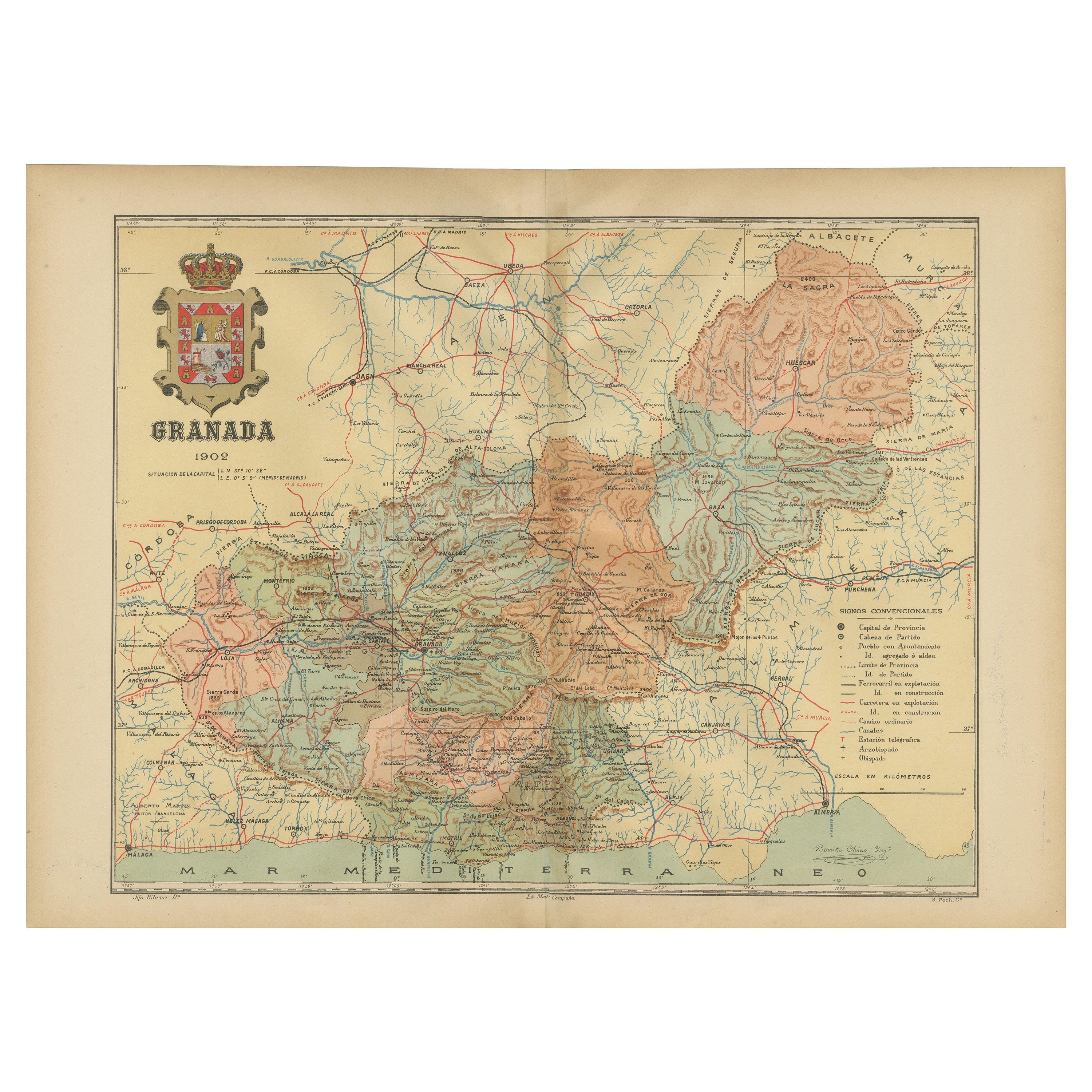
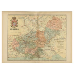
- Granada 1902: A Cartographic Exploration of Andalusia's Mountainous ProvinceLocated in Langweer, NLThis original antique map depicts the province of Granada, part of the autonomous community of Andalusia in southern Spain, as of 1902. The map features several important details: I...Category
Antique Early 1900s Maps
MaterialsPaper
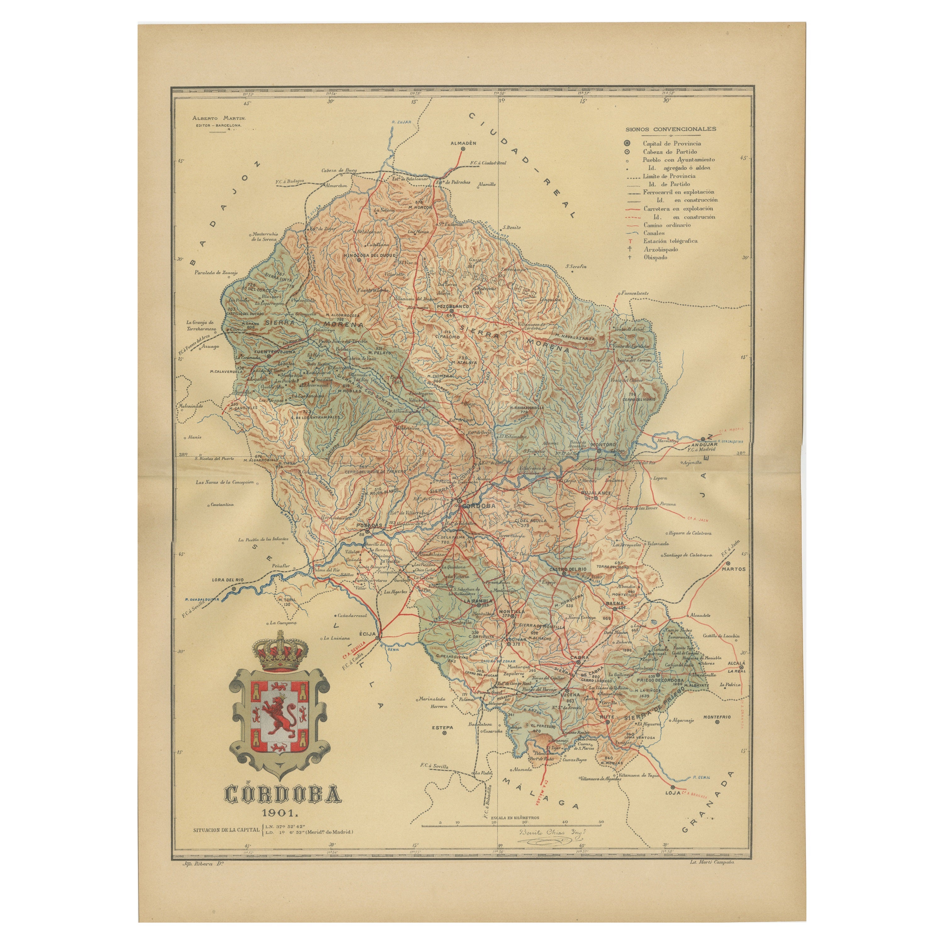
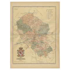
- Córdoba 1901: A Cartographic Journey Through Andalusia’s Heartland in SpainLocated in Langweer, NLThe map provided is of the province of Córdoba, part of the autonomous community of Andalusia in southern Spain, as of the year 1901. It details various elements: The map displays the varied terrain of Córdoba, including the Sierra Morena to the north and the beginning of the Subbaetic Range to the south. It shows blue lines indicating rivers, most likely including the Guadalquivir River, which runs through the province. Red lines represent the transportation network of roads and railways, detailing how the province is interconnected. Symbols on the map mark the locations of cities, towns, and villages, with the capital city of Córdoba highlighted. Dotted lines suggest the borders of the province within the region of Andalusia. A legend (Signos Convencionales) details the symbols used for provincial capitals, roads, railways, and other features. A scale in kilometers is included to assist in measuring distances between points on the map. The coat of arms of Córdoba is prominently featured, displaying a castle and a lion, which are common heraldic symbols with historical significance to the region. About the province of Córdoba: Córdoba is historically significant, known for its cultural heritage, particularly during the time when it was the capital of the Islamic Emirate and then Caliphate of Córdoba. This period left a lasting architectural mark, notably the Mezquita-Catedral (Mosque-Cathedral), which is a UNESCO World Heritage site. The province's geography is diverse, with fertile valleys in the Guadalquivir basin and extensive olive groves, making it one of the most important areas for olive oil production...Category
Antique Early 1900s Maps
MaterialsPaper
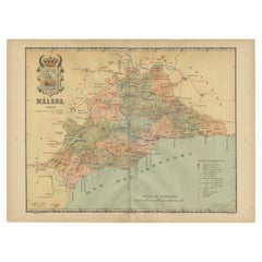
- Málaga 1901: A Cartographic Detailing of Andalusia's Coastal JewelLocated in Langweer, NLThe map depicts the province of Málaga, located in the autonomous community of Andalusia in southern Spain, as it was in 1901. Here are the key features illustrated on the map: - **...Category
Antique Early 1900s Maps
MaterialsPaper
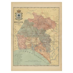
- Huelva 1901: A Cartographic Presentation of Andalusia's Atlantic FrontierLocated in Langweer, NLThe map displays the province of Huelva, located in the southwestern part of the autonomous community of Andalusia in Spain, as of the year 1901. It outlines various geographic and m...Category
Antique Early 1900s Maps
MaterialsPaper
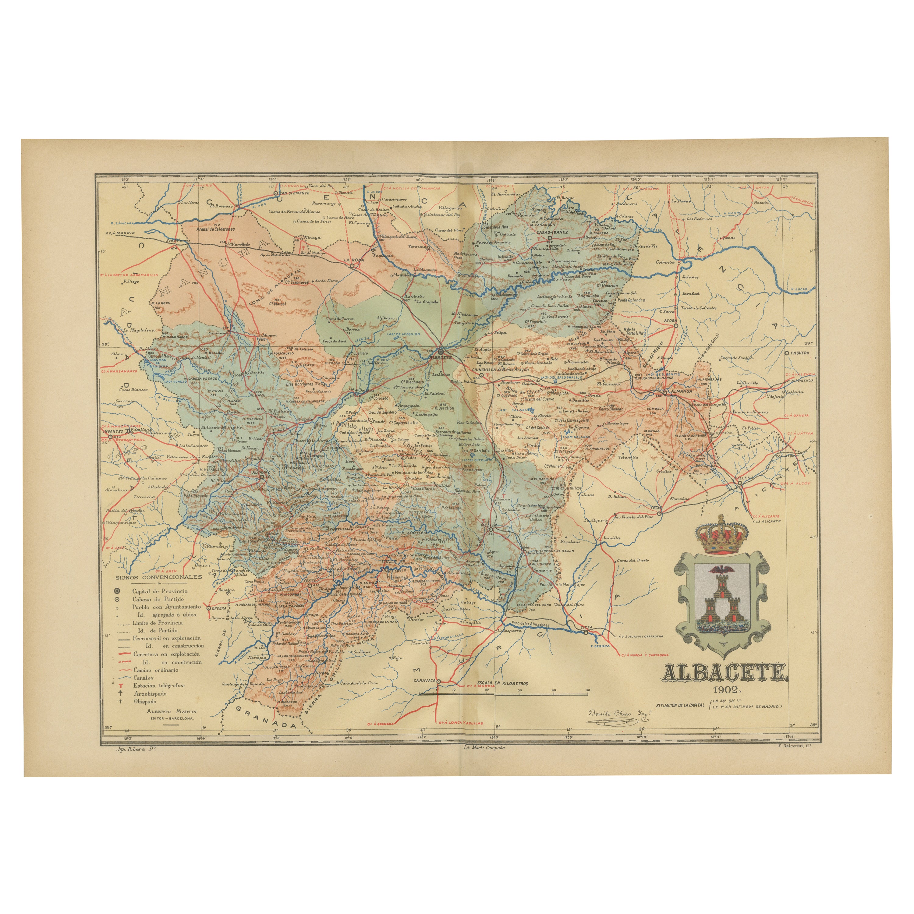
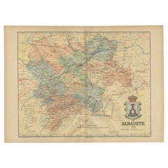
- Albacete, Spain - 1902: A Cartographic Depiction of Landscape and InfrastructureLocated in Langweer, NLAlbacete, Spain - 1902: A Cartographic Depiction of Landscape and Infrastructure An original and historical map of the province of Albacete, dated 1902, from the "Atlas Geográfico I...Category
Antique Early 1900s Maps
MaterialsPaper
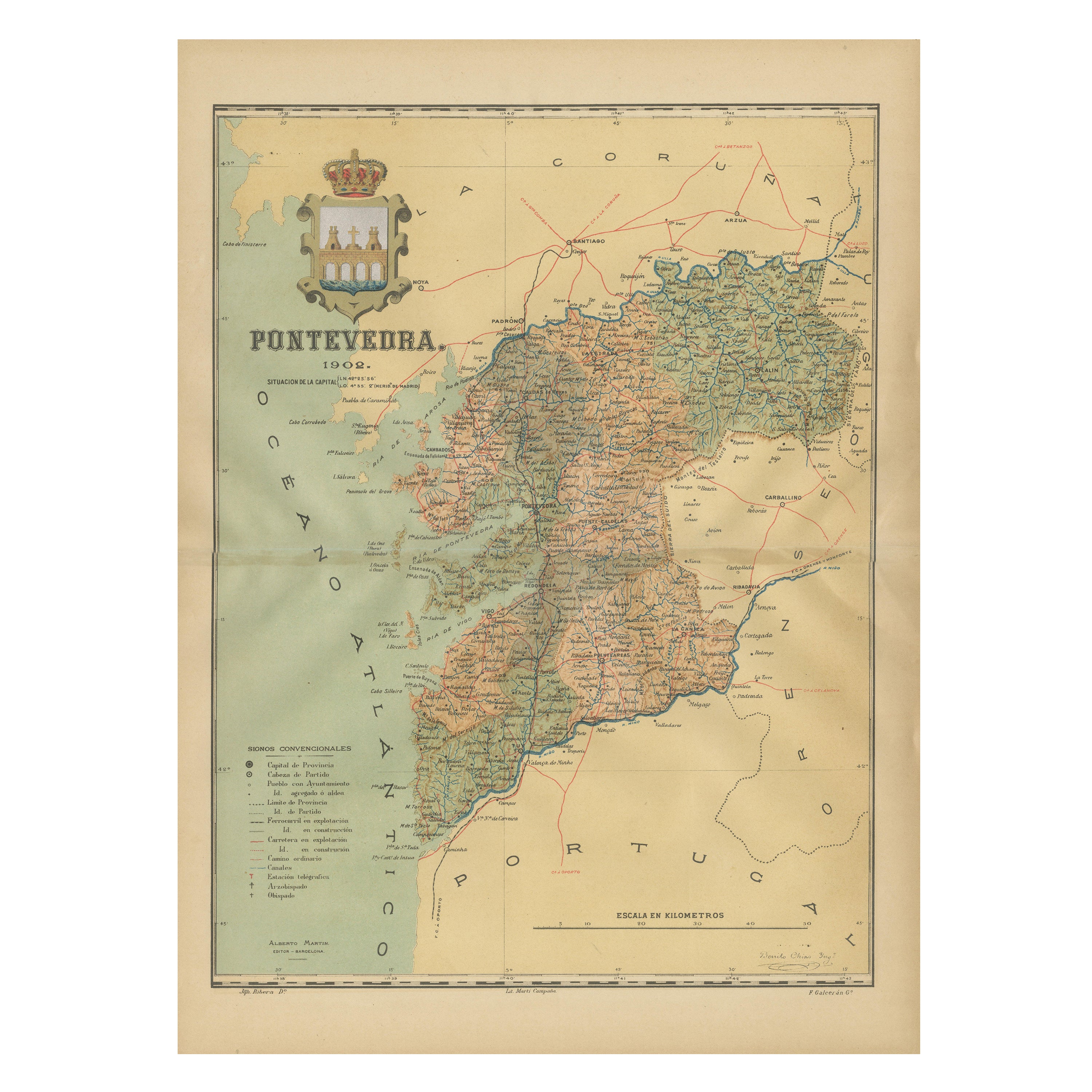
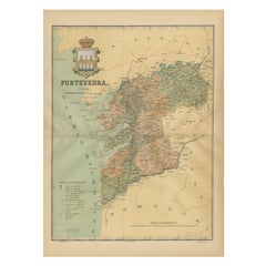
- Cartographic Survey of Pontevedra, 1902: Crossroads of Galicia"Located in Langweer, NLThis original old map of over 100 years old depicts the province of Pontevedra as it was in 1902. Pontevedra is located in the northwest of Spain, in the autonomous community of Gali...Category
Antique Early 1900s Maps
MaterialsPaper
You May Also Like
- Antique Lithography Map of Cheshire, English, Framed, Cartography, VictorianLocated in Hele, Devon, GBThis is an antique lithography map of Cheshire. An English, framed atlas engraving of cartographic interest, dating to the mid 19th century and lat...Category
Antique Mid-19th Century British Victorian Maps
MaterialsWood
- Sun and Moon a Story of Astronomy, Photography and CartographyLocated in New York City, NYA unique pictorial history of astronomical exploration from the earliest Prehistoric observatories to the latest satellite images with 280 spectacular images and an inspiring story i...Category
21st Century and Contemporary European Books
MaterialsPaper
- Antique Lithography Map, Isle of Wight, English, Framed, Engraving, CartographyLocated in Hele, Devon, GBThis is an antique lithography map of the Isle of Wight. An English, framed atlas engraving of cartographic interest, dating to the early 19th century and later. Superb lithography ...Category
Antique Early 19th Century British Regency Maps
MaterialsWood
- Very Large Vintage Map of Canada, German, Education, Institution, CartographyLocated in Hele, Devon, GBThis is a very large vintage map of Canada. A German, quality printed educational or institution map, dating to the mid 20th century, circa 1965....Category
Mid-20th Century German Maps
MaterialsPaper
- Antique Lithography Map, Isle of Thanet, Kent, English, Cartography, VictorianLocated in Hele, Devon, GBThis is an antique lithography map of The Isle of Thanet in Kent. An English, framed atlas engraving of cartographic interest, dating to the mid 19th century and later. Superb litho...Category
Antique Mid-19th Century British Victorian Maps
MaterialsWood
- Antique Oarsman's Map of the River Thames, English, Cartography, Published 1912Located in Hele, Devon, GBThis is an antique copy of The Oarsman's and Angler's Map of the River Thames - New Edition. An English, bound map book, published in English by Edward Stanford, London, this new edi...Category
Early 20th Century British Other Books
MaterialsPaper


Recently Viewed
View AllMore Ways To Browse
Map Of Old Armenia
Teak Wood Sphere
Nova Guinea Maps
Antique Map Of Illinois
Petite Point Hand Bag
Antique Map Of Southeastern Us
Antique Map Alabama
Antique Map Of Sydney
Malay Archipelago Map
Gambia Antique Map
Uruguay Antique Map
Guyana Antique Map
Ruscelli Map
Masque Theatre No
Nova Scotia Map
Antique Map Tuscany
Berkshire Antique Map
Cornwall Map