Items Similar to Antique Map of Alentejo: Land of Tradition and Tranquility, 1903


Want more images or videos?
Request additional images or videos from the seller
1 of 7
Antique Map of Alentejo: Land of Tradition and Tranquility, 1903
About the Item
The image is a historical original antique map of the Alentejo region in Portugal. This map includes the topographical layout of the region, with its complex network of roads and waterways, and features the city of Évora, which seems to be highlighted as an important location. The Alentejo is known for its rolling landscapes, vineyards, olive groves, and rich history, including numerous prehistoric and Roman sites. Évora itself is a UNESCO World Heritage site, known for its well-preserved old town center, Roman temple, and chapel of bones.
The map also includes the coats of arms of Beja and Évora, suggesting the map's focus on the administrative divisions within Alentejo. The region's vast plains, cork production, and historical significance are some of the key characteristics that would be of interest in a catalogue or guide.
The Alentejo region, encompassing a considerable portion of central and southern Portugal, is notable for several distinctive characteristics:
1. **Cultural Heritage**: Alentejo is home to a rich array of cultural landmarks. The historic center of Évora, a UNESCO World Heritage Site, is a treasure trove of history, featuring a Roman temple, medieval walls, and a 16th-century aqueduct.
2. **Agriculture**: The region is known for its extensive olive groves and vineyards, producing high-quality olive oil and wines. It's also a major producer of cork, with vast cork oak forests that are sustainably harvested.
3. **Cuisine**: Alentejo's culinary tradition is robust and flavorsome, with dishes like açorda (bread-based dish with garlic, cilantro, eggs, and olive oil), and carne de porco à alentejana (pork with clams).
4. **Landscapes**: The area is characterized by rolling plains, which in spring are covered with a blanket of wildflowers. The Alqueva Dam has created a large artificial lake, offering recreational activities and beautiful scenery.
5. **Prehistoric Sites**: Alentejo is rich in prehistoric remains, including the Cromeleque dos Almendres, one of the largest groups of structured menhirs in Europe.
6. **Architecture**: The region's architecture is marked by white-washed houses, historic castles, and Roman ruins, providing a picturesque setting that reflects its history.
7. **Tranquility**: Alentejo is less densely populated than other regions in Portugal, offering a sense of tranquility and an escape from the hustle and bustle of city life.
8. **Coastline**: The Alentejo coast boasts some of the most pristine and least crowded beaches in Portugal, with dramatic cliffs and clear waters.
9. **Music and Dance**: Traditional Alentejo music, particularly the Cante Alentejano, a form of polyphonic singing, is recognized by UNESCO as an Intangible Cultural Heritage.
These elements make Alentejo a region of serene beauty, deep historical roots, and rich cultural expressions.
- Dimensions:Height: 20.08 in (51 cm)Width: 14.77 in (37.5 cm)Depth: 0 in (0.02 mm)
- Materials and Techniques:
- Period:1900-1909
- Date of Manufacture:1903
- Condition:Good condition. Central vertical folding lines as issued. Aged paper with typically warm, yellowish-brown hue, especially around the edges and folding lines, adding to its patina. Check the images carefully.
- Seller Location:Langweer, NL
- Reference Number:
About the Seller
5.0
Platinum Seller
These expertly vetted sellers are 1stDibs' most experienced sellers and are rated highest by our customers.
Established in 2009
1stDibs seller since 2017
1,919 sales on 1stDibs
Typical response time: <1 hour
- ShippingRetrieving quote...Ships From: Langweer, Netherlands
- Return PolicyA return for this item may be initiated within 14 days of delivery.
More From This SellerView All
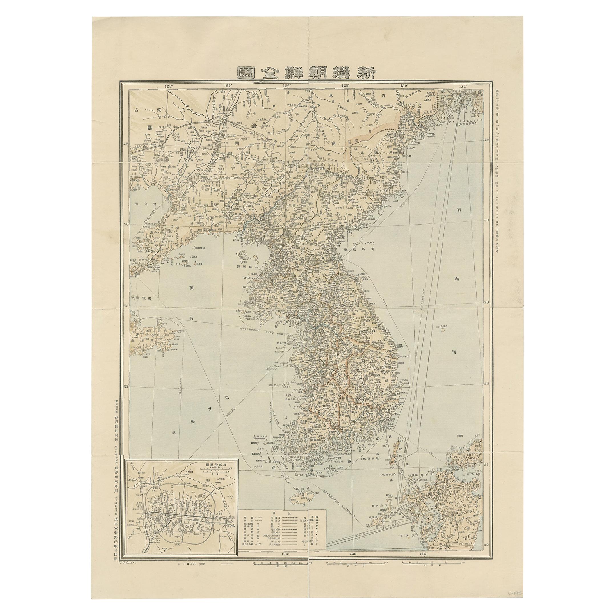
- Antique Map of Korea by Kozaki, 1903Located in Langweer, NLOld map of Korea by S. Kozaki. Restored and mounted.Category
20th Century Maps
MaterialsPaper
- Antique Map of the Holy Land, c.1717Located in Langweer, NLAntique map Israel titled 'Tabula Geographica Terrae Sanctae'. Rare edition made after a map of the Holy Land by J. Bonfrerius. The map is oriented ...Category
Antique 18th Century Maps
MaterialsPaper
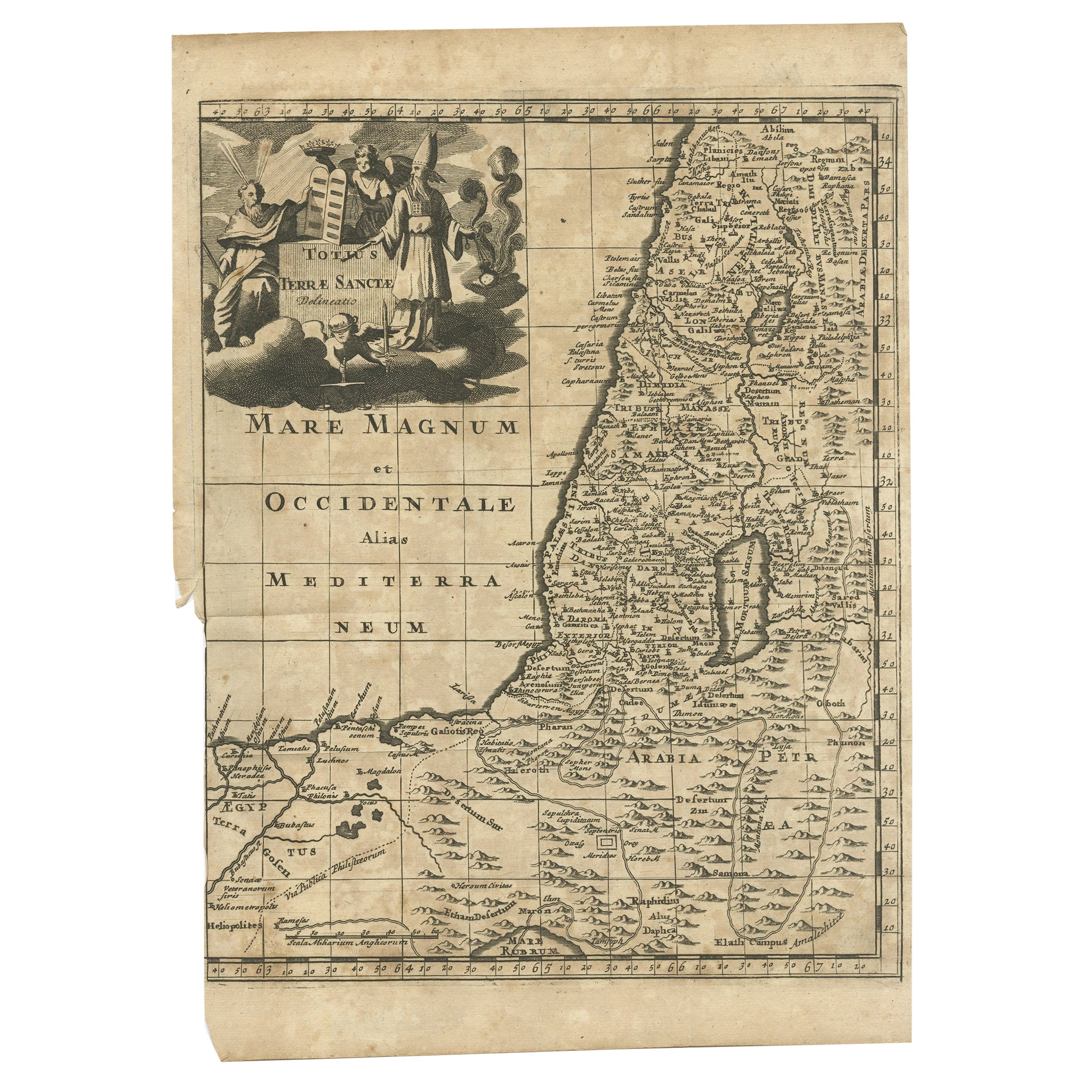
- Antique Map of the Holy Land, c.1710Located in Langweer, NLAntique map titled 'Totius Terrae Sanctae Delineatio'. Map of the Holy Land extending to Egypt and showing the route of the Children of Israel in their e...Category
Antique 18th Century Maps
MaterialsPaper
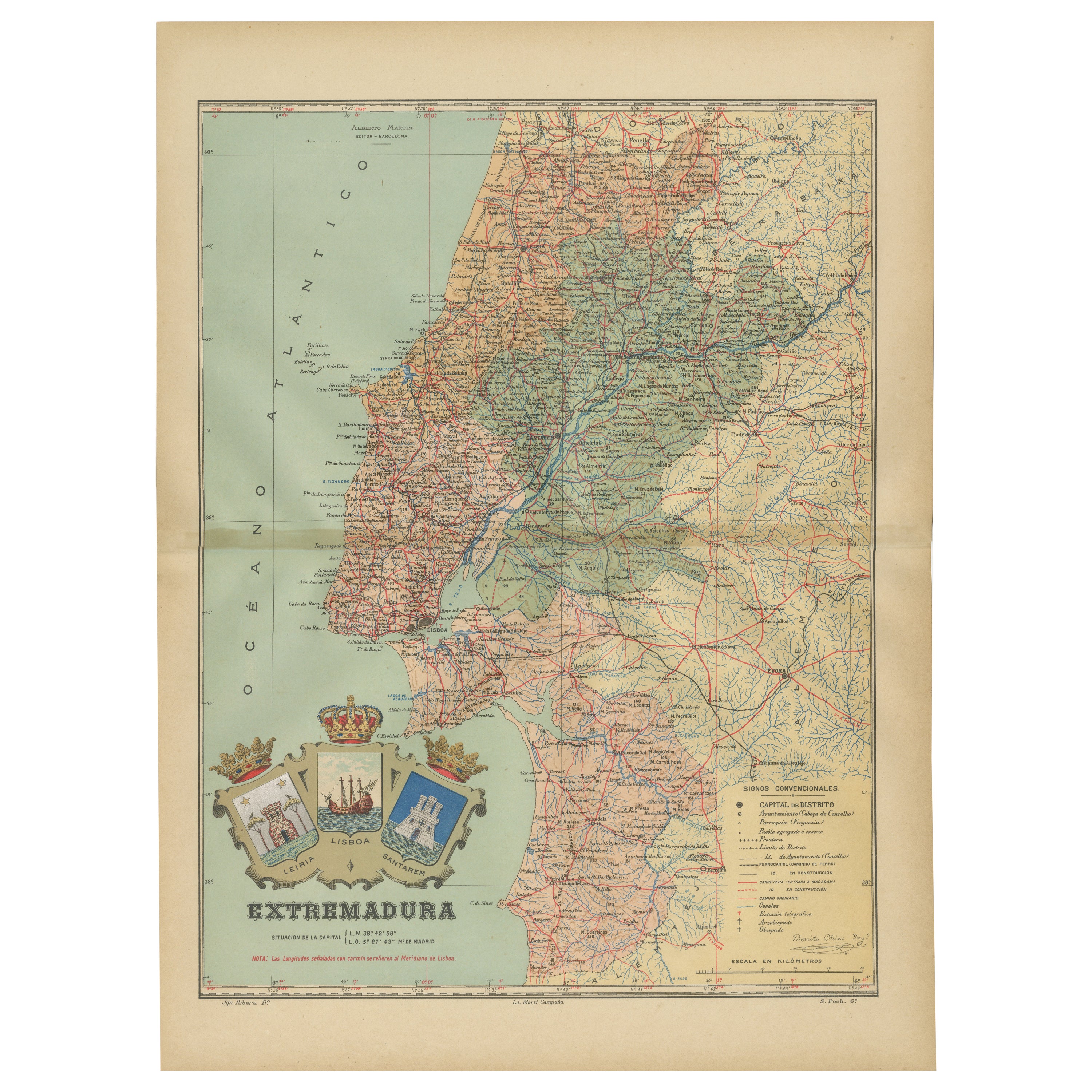
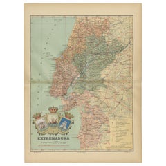
- An Antique Map of Extremadura: Crossroads of History and Nature, 1903Located in Langweer, NLThe image is a historical map of Extremadura, an autonomous community of Spain, from an unspecified year. The map features the region's topography, including mountain ranges, river s...Category
Antique Early 1900s Maps
MaterialsPaper
- Antique Map of Landes ‘France’ by V. Levasseur, 1854By Victor LevasseurLocated in Langweer, NLAntique map titled 'Dépt. des Landes'. Map of the French department Landes, France. This area is known for its production of Chalossais, a white cow cheese with a gentle, acidic edge...Category
Antique Mid-19th Century Maps
MaterialsPaper
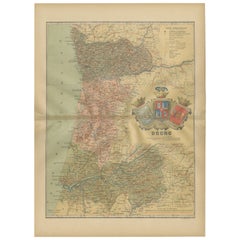
- Douro: The River of Tradition and Wine in Portugal, 1903Located in Langweer, NLThe uploaded image is a historical map of the Beira Baixa region in Portugal. The map details the topography, including mountain ranges and river systems, as well as the transportati...Category
Antique Early 1900s Maps
MaterialsPaper


You May Also Like
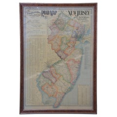
- 1903 Antique National Publishing Road Map of New Jersey Geological SurveyLocated in Dayton, OH1903 antique New Jersey road map by The National Publishing Company of Boston Massachusettes, No 384. Index for New Jersey Census 1900, Population 1...Category
Antique Early 1900s Victorian Maps
MaterialsPaper
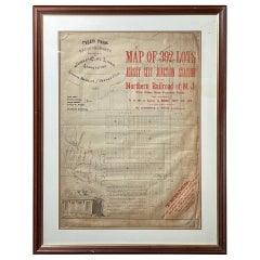
- Framed Original Land Map Survey of Tyler Park, Jersey City RailroadLocated in Lambertville, NJA framed and matted historical map of Tyler park jersey city New Jersey Railroad. The paper on canvas in later appropriate frame. Good condition with some creasing and age discolorat...Category
Antique 1870s American Posters
MaterialsCanvas, Glass, Wood
- 1854 Map of Massachusetts, Connecticut and Rhode Island, Antique Wall MapLocated in Colorado Springs, COThis striking wall map was published in 1854 by Ensign, Bridgman & Fanning and has both full original hand-coloring and original hardware. This impression is both informative and highly decorative. The states are divided into counties, outlined in red, green, and black, and subdivided into towns. Roads, canals, and railroad lines are prominently depicted, although they are not all labeled. The mapmakers also marked lighthouses, banks, churches, and prominent buildings, with a key at right. The map is an informative and comprehensive overview of the infrastructural development of New England prior to the Civil War. Physical geographies depicted include elevation, conveyed with hachure marks, rivers and lakes. The impression features an inset map of Boston...Category
Antique 19th Century American Maps
MaterialsPaper
- Antique Map of Principality of MonacoBy Antonio Vallardi EditoreLocated in Alessandria, PiemonteST/619 - "Old Geographical Atlas of Italy - Topographic map of ex-Principality of Monaco" - ediz Vallardi - Milano - A somewhat special edition ---Category
Antique Late 19th Century Italian Other Prints
MaterialsPaper
- Original Antique Map of Spain and Portugal, circa 1790Located in St Annes, LancashireSuper map of Spain and Portugal Copper plate engraving by A. Bell Published, circa 1790. Unframed.Category
Antique 1790s English Other Maps
MaterialsPaper
- Original Antique Map of Ireland- Tipperary and Waterford. C.1840Located in St Annes, LancashireGreat map of Tipperary and Waterford Steel engraving Drawn under the direction of A.Adlard Published by How and Parsons, C.1840 Unframed.Category
Antique 1840s English Maps
MaterialsPaper


Recently Viewed
View AllMore Ways To Browse
Map Of Old Armenia
Teak Wood Sphere
Nova Guinea Maps
Antique Map Of Illinois
Petite Point Hand Bag
Antique Map Of Southeastern Us
Antique Map Alabama
Antique Map Of Sydney
Malay Archipelago Map
Gambia Antique Map
Uruguay Antique Map
Guyana Antique Map
Ruscelli Map
Masque Theatre No
Nova Scotia Map
Antique Map Tuscany
Berkshire Antique Map
Cornwall Map