Items Similar to An Antique Map of Extremadura: Crossroads of History and Nature, 1903


Want more images or videos?
Request additional images or videos from the seller
1 of 7
An Antique Map of Extremadura: Crossroads of History and Nature, 1903
About the Item
The image is a historical map of Extremadura, an autonomous community of Spain, from an unspecified year. The map features the region's topography, including mountain ranges, river systems, and road networks. Extremadura is bordered by Portugal to the west and is situated to the southwest of Madrid. The map also includes the coat of arms of Lisbon (Lisboa), possibly indicating the historical connections between the two regions, as Lisbon is close to the border of Extremadura.
Extremadura is known for its:
1. **Natural Landscapes**: The region has diverse landscapes, including the mountainous areas in the north and the fertile plains (known as the dehesa) used for grazing pigs, which produce the famous Iberian ham.
2. **Historical Significance**: Extremadura was the birthplace of many famous conquistadors, such as Hernán Cortés and Francisco Pizarro. The region's towns and cities, like Mérida and Cáceres, have impressive Roman and medieval architecture.
3. **Cultural Heritage**: UNESCO World Heritage Sites such as the Old Town of Cáceres and the Archaeological Ensemble of Mérida are located here.
4. **Agriculture**: The region is also known for its agriculture, particularly for the production of cherries in the Jerte Valley and paprika in La Vera.
5. **Monfragüe National Park**: A renowned birdwatching destination with a significant population of birds of prey.
6. **Guadalupe Monastery**: The Royal Monastery of Santa María de Guadalupe is another World Heritage Site and a significant pilgrimage destination.
- Dimensions:Height: 20.08 in (51 cm)Width: 14.77 in (37.5 cm)Depth: 0 in (0.02 mm)
- Materials and Techniques:
- Period:1900-1909
- Date of Manufacture:1903
- Condition:Good condition. Central vertical folding lines as issued. Aged paper with typically warm, yellowish-brown hue, especially around the edges and folding lines, adding to its patina. Check the images carefully.
- Seller Location:Langweer, NL
- Reference Number:
About the Seller
5.0
Platinum Seller
These expertly vetted sellers are 1stDibs' most experienced sellers and are rated highest by our customers.
Established in 2009
1stDibs seller since 2017
1,928 sales on 1stDibs
Typical response time: <1 hour
- ShippingRetrieving quote...Ships From: Langweer, Netherlands
- Return PolicyA return for this item may be initiated within 14 days of delivery.
More From This SellerView All
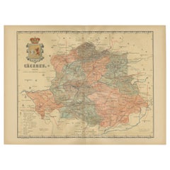
- Cáceres 1901: Mapping the Crossroads of Extremadura, Western SpainLocated in Langweer, NLThe map depicts the province of Cáceres in Spain, dated 1901. Key features of the map include: The map shows detailed contour lines indicating the diverse terrain, which includes the northern part of the province being part of the Sistema Central mountain range. Blue lines mark the rivers and larger bodies of water, likely including the Tagus River, which passes through the province. Red lines indicate roads and railways, highlighting the connections within the province and to neighboring areas. The coat of arms of Cáceres is featured prominently, displaying a castle and a lion, symbols associated with the historical heritage of the region. It is highlighted with a gold coating in the crown. About the province of Cáceres: Cáceres is one of the two provinces in the autonomous community of Extremadura, in western Spain, bordering Portugal. The province is known for its extensive natural environments, including part of the Monfragüe National Park, which is a UNESCO-designated Biosphere Reserve, and the Tagus River International Natural Park. The capital city, also named Cáceres, boasts a well-preserved old town with a wealth of Renaissance architecture...Category
Antique Early 1900s Maps
MaterialsPaper
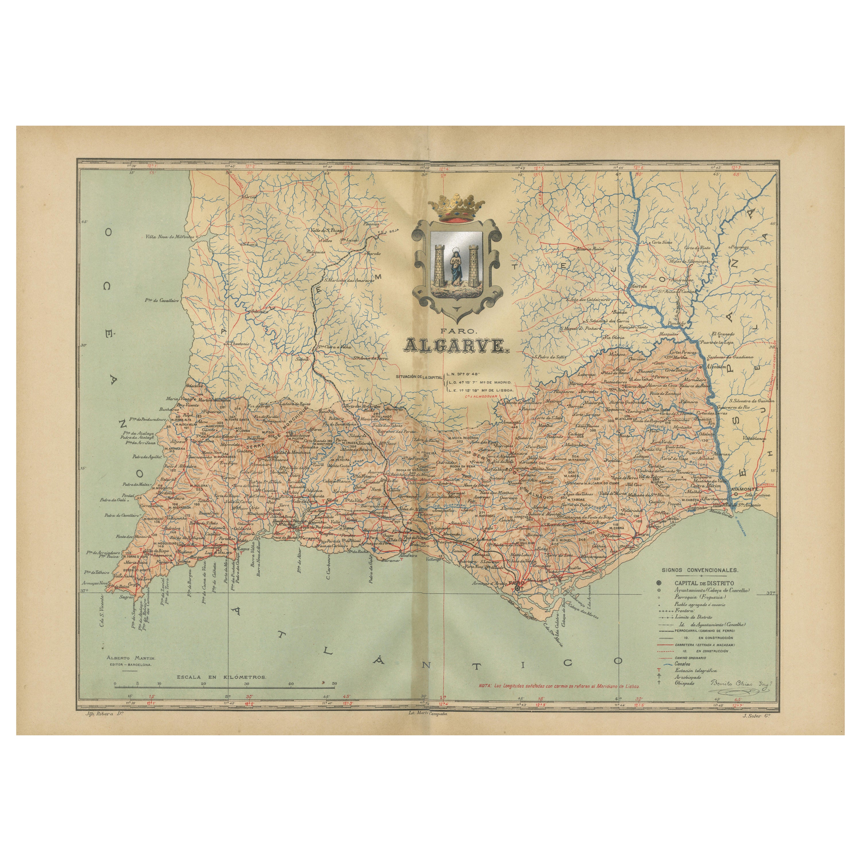
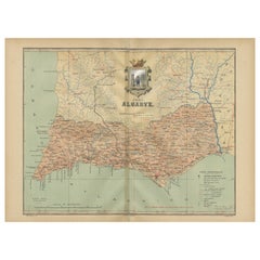
- Algarve: A Tapestry of Sea and Sunlight in an Antique Map, 1903Located in Langweer, NLThe image is a historical map of the Algarve, the southernmost region of Portugal. The map is titled "FARO. ALGARVE," indicating that it is centered around the city of Faro, which is...Category
Antique Early 1900s Maps
MaterialsPaper
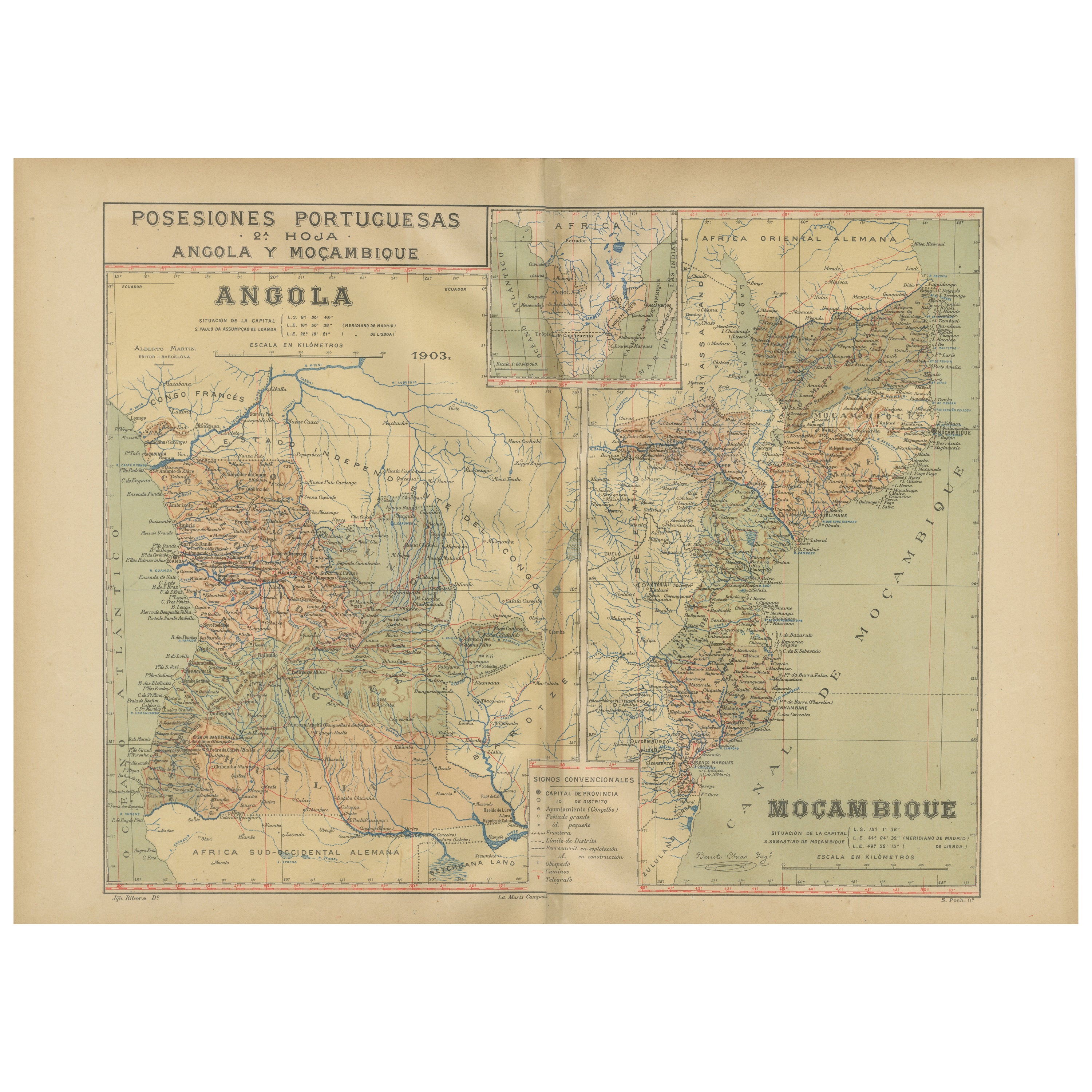
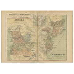
- Colonial Crossroads: Angola and Mozambique in 1903Located in Langweer, NLThe image for sale is an original historical map from 1903 that shows the Portuguese colonies of Angola on the left and Mozambique on the right. These two territories on the African ...Category
Antique Early 1900s Maps
MaterialsPaper
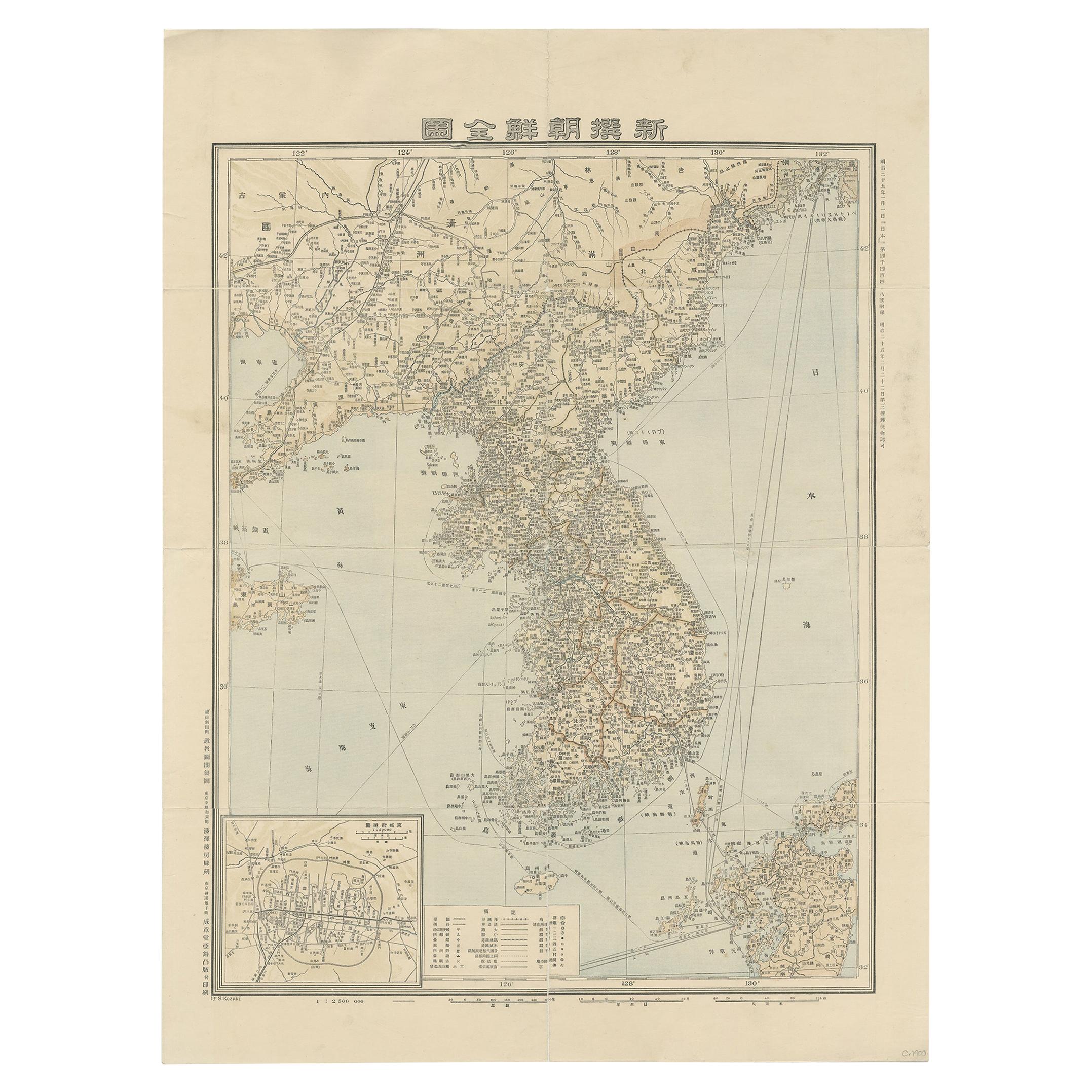
- Antique Map of Korea by Kozaki, 1903Located in Langweer, NLOld map of Korea by S. Kozaki. Restored and mounted.Category
20th Century Maps
MaterialsPaper
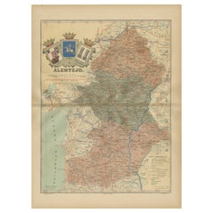
- Antique Map of Alentejo: Land of Tradition and Tranquility, 1903Located in Langweer, NLThe image is a historical original antique map of the Alentejo region in Portugal. This map includes the topographical layout of the region, with its complex network of roads and wat...Category
Antique Early 1900s Maps
MaterialsPaper
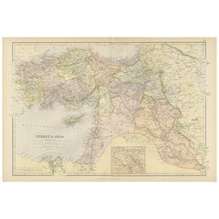
- Empire's Crossroads: An 1882 Map of Turkey in Asia by Blackie & SonLocated in Langweer, NLThis map, titled "Turkey in Asia," is another detailed illustration from the 1882 atlas by Blackie & Son. It showcases the vastness of the Asian territories of the Ottoman Empire, sp...Category
Antique 1880s Maps
MaterialsPaper

You May Also Like
- Canals & Crossroads An illustrated History of Albany, NY Roman Catholic DioceseLocated in valatie, NYCanals & Crossroads: An illustrated History of Albany, New York Roman Catholic Diocese. Albany Catholic Press Association, Incorporated, 1997. Stated fi...Category
1990s American Books
MaterialsPaper
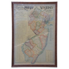
- 1903 Antique National Publishing Road Map of New Jersey Geological SurveyLocated in Dayton, OH1903 antique New Jersey road map by The National Publishing Company of Boston Massachusettes, No 384. Index for New Jersey Census 1900, Population 1...Category
Antique Early 1900s Victorian Maps
MaterialsPaper
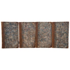
- 4 Antique 1808 Goldsmiths History of Earth Animated Nature Leather Book Vol I-IVLocated in Dayton, OHEarly 19th century four volume hard cover book set – marbled board covers with leather spine. A History of the Earth and Animated Nature – In Four Volumes – by Oliver Goldsmith – A N...Category
Antique Early 1800s Books
MaterialsLeather, Paper
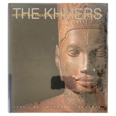
- The Khmers History and Treasures of an Ancient Civilization Art BookLocated in North Hollywood, CAThe Khmers History and Treasures of an Ancient Civilization by Stefano Vecchia. This is a history of the Khmers, the people who for thousands of years inhabited the wooded interior o...Category
20th Century Asian Tribal Books
MaterialsPaper
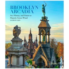
- Brooklyn Arcadia: Art, History, and Nature at Majestic Green-WoodBy Rizzoli International PublicationsLocated in New York, NYThe New York City treasure, newly photographed, is revealed as garden in the city, repository for memory, and a place for repose, inspiration, and delight. Green-Wood is a living cemetery that brings people closer to the world by memorializing the dead even as it embraces the art, history, and natural beauty of New York. Founded in 1838 and now a National Historic Landmark, Green-Wood was one of the first rural cemeteries in America. By the early 1860s, it had earned an international reputation for its beauty, attracting 500,000 visitors a year, second only to Niagara Falls as the nation’s greatest tourist attraction. Crowds flocked here to enjoy family outings in the finest of first-generation American landscapes. Green-Wood’s popularity helped inspire the creation of public parks, including New York City’s Central and Prospect parks. Green-Wood is 478 spectacular acres of hills, valleys, glacial ponds, and paths, throughout which exists one of the largest outdoor collections of nineteenth- and twentieth-century statuary and mausoleums. Four seasons of beauty offer a peaceful oasis to visitors, as well as its 570,000 permanent residents, including Leonard Bernstein, Boss Tweed, Jean-Michel Basquiat, and Louis Comfort Tiffany. At once a celebration and an invitation, the book ranges from a consideration of the natural landscape in which it is set to a close look at its architecture, statuary, symbols, typography, birds and fauna, trees, and typography. About The Author Andrew Garn is a fine art and editorial photographer whose recent books for Rizzoli include New York Deco...Category
21st Century and Contemporary Books
MaterialsPaper
- Gold, An Illustrated History, First EditionBy Vincent BuranelliLocated in valatie, NYGold, An Illustrated History by Vincent Buranelli. Maplewood: Hammond Incorporated, 1979. First edition hardcover with dust jacket. 221 pp. A book on the history and the love of gold. Illustrated are the masterworks of the Egyptians, Thracians, and Roman and Greek treasures along with masterpieces from the Renaissance. Described are the smugglers, grave robbers, sunken treasures...Category
20th Century American Books
MaterialsPaper

Recently Viewed
View AllMore Ways To Browse
Map Of Old Armenia
Teak Wood Sphere
Nova Guinea Maps
Antique Map Of Illinois
Petite Point Hand Bag
Antique Map Of Southeastern Us
Antique Map Alabama
Antique Map Of Sydney
Malay Archipelago Map
Gambia Antique Map
Uruguay Antique Map
Guyana Antique Map
Ruscelli Map
Masque Theatre No
Nova Scotia Map
Antique Map Tuscany
Berkshire Antique Map
Cornwall Map