Items Similar to Anrtique Map of the Province of Valladolid, Central Spain, 1902


Want more images or videos?
Request additional images or videos from the seller
1 of 6
Anrtique Map of the Province of Valladolid, Central Spain, 1902
$298.29
$372.8620% Off
£224.96
£281.2120% Off
€256
€32020% Off
CA$412.41
CA$515.5120% Off
A$461.97
A$577.4620% Off
CHF 242.64
CHF 303.3020% Off
MX$5,617.40
MX$7,021.7520% Off
NOK 3,072.65
NOK 3,840.8220% Off
SEK 2,916.77
SEK 3,645.9720% Off
DKK 1,948.84
DKK 2,436.0520% Off
About the Item
A historical or archival map of the province of Valladolid, Spain, from the year 1902. Valladolid is a province located in the central part of Spain, within the autonomous community of Castilla y León. The capital city of the province also named Valladolid, is historically significant as it was once the capital of Spain.
Key characteristics of Valladolid province would include its rich cultural heritage, with a significant number of churches, palaces, and other buildings reflecting its past as a center of Spanish power and influence. It has a continental climate with cold winters and hot summers, and the region is known for its wine production, particularly the Ribera del Duero DO (Denominación de Origen).
The map likely shows a network of roads and railways as they existed in the early 20th century, which facilitated trade and movement within the province. The province's geographical features such as the Douro River (Pisuerga River as a tributary), which runs through the city of Valladolid, and the surrounding plains would also be of note. Valladolid is also known for its natural environments, including the "Riberas de Castronuño-Vega del Duero" Natural Reserve.
The map would be of interest to historians, geographers, and those studying urban development, transportation history, or viticulture in Spain. For someone looking to understand the historical layout and the infrastructure of Valladolid at the beginning of the 20th century, this map would provide valuable insights.
- Dimensions:Height: 14.77 in (37.5 cm)Width: 20.08 in (51 cm)Depth: 0 in (0.02 mm)
- Materials and Techniques:
- Period:1900-1909
- Date of Manufacture:1902
- Condition:Good condition. Central vertical folding lines as issued. Aged paper with typically warm, yellowish-brown hue, especially around the edges and folding lines. Check the images carefully.
- Seller Location:Langweer, NL
- Reference Number:Seller: BG-13642-441stDibs: LU3054338033342
About the Seller
5.0
Recognized Seller
These prestigious sellers are industry leaders and represent the highest echelon for item quality and design.
Platinum Seller
Premium sellers with a 4.7+ rating and 24-hour response times
Established in 2009
1stDibs seller since 2017
2,517 sales on 1stDibs
Typical response time: <1 hour
- ShippingRetrieving quote...Shipping from: Langweer, Netherlands
- Return Policy
Authenticity Guarantee
In the unlikely event there’s an issue with an item’s authenticity, contact us within 1 year for a full refund. DetailsMoney-Back Guarantee
If your item is not as described, is damaged in transit, or does not arrive, contact us within 7 days for a full refund. Details24-Hour Cancellation
You have a 24-hour grace period in which to reconsider your purchase, with no questions asked.Vetted Professional Sellers
Our world-class sellers must adhere to strict standards for service and quality, maintaining the integrity of our listings.Price-Match Guarantee
If you find that a seller listed the same item for a lower price elsewhere, we’ll match it.Trusted Global Delivery
Our best-in-class carrier network provides specialized shipping options worldwide, including custom delivery.More From This Seller
View AllTopographical and Infrastructure Map of the Province of Valencia, 1901
Located in Langweer, NL
A historical map of the province of Valencia, dated 1901. The map includes intricate details such as topographical features, with mountain ranges and river systems prominently marked...
Category
Antique Early 1900s Maps
Materials
Paper

$484 Sale Price
20% Off
Free Shipping
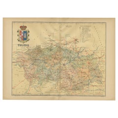
Toledo 1902: A Historical Cartographic Study of this Spanish Province
Located in Langweer, NL
The print is a historical map of the province of Toledo from 1902. It's a detailed, colored map, highlighting topographical features, such as mountain ranges and rivers, as well as i...
Category
Antique Early 1900s Maps
Materials
Paper
$307 Sale Price
20% Off
Free Shipping
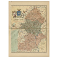
Antique Map of Alentejo: Land of Tradition and Tranquility, 1903
Located in Langweer, NL
The image is a historical original antique map of the Alentejo region in Portugal. This map includes the topographical layout of the region, with its complex network of roads and wat...
Category
Antique Early 1900s Maps
Materials
Paper
Navarra in Cartographic Detail: A 1902 Map of the Crossroads of Northern Spain
Located in Langweer, NL
The original antique map for sale shows the Spanish province of Navarra as it was in 1902. Here's a brief description and a potential title for the map:
Description:
- The map detai...
Category
Antique Early 1900s Maps
Materials
Paper

$316 Sale Price
20% Off
Free Shipping
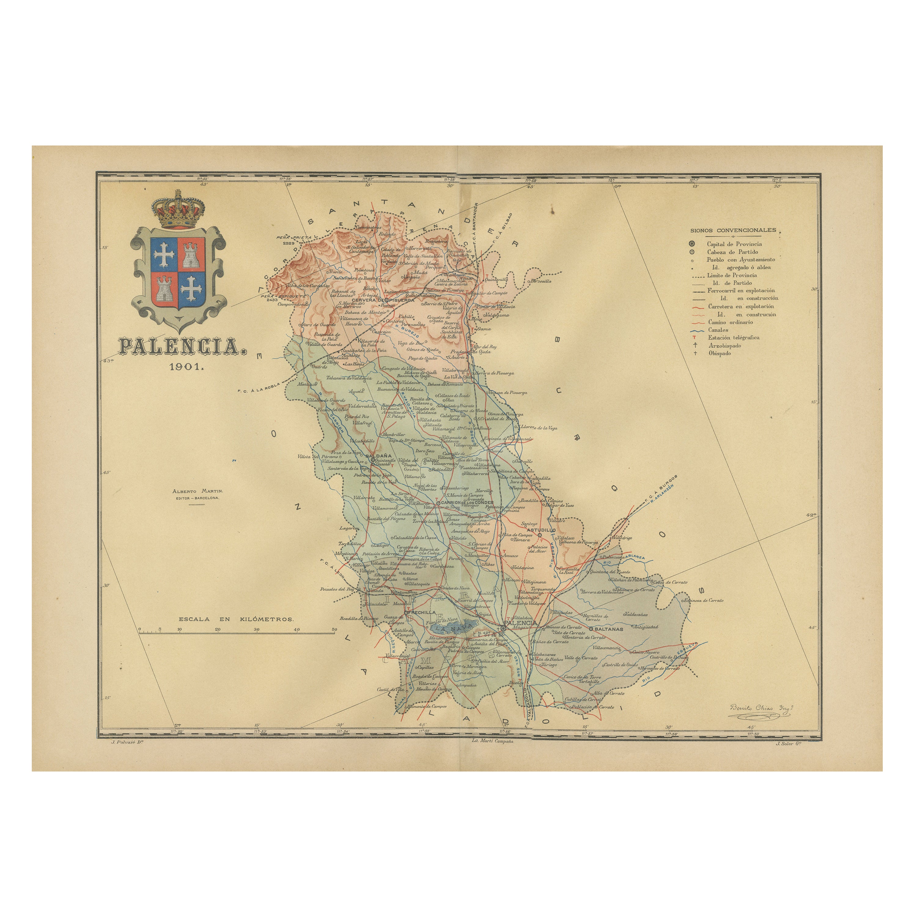
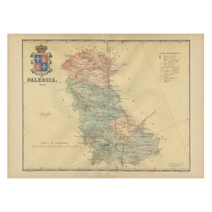
Original Antique Map of Palencia Province, in Northern Spain, 1901
Located in Langweer, NL
This historical map is of Palencia, a province in the northern part of Spain.
Palencia is situated within the autonomous community of Castilla y León. It is bordered by the provinc...
Category
Antique Early 1900s Maps
Materials
Paper
$363 Sale Price
20% Off
Free Shipping
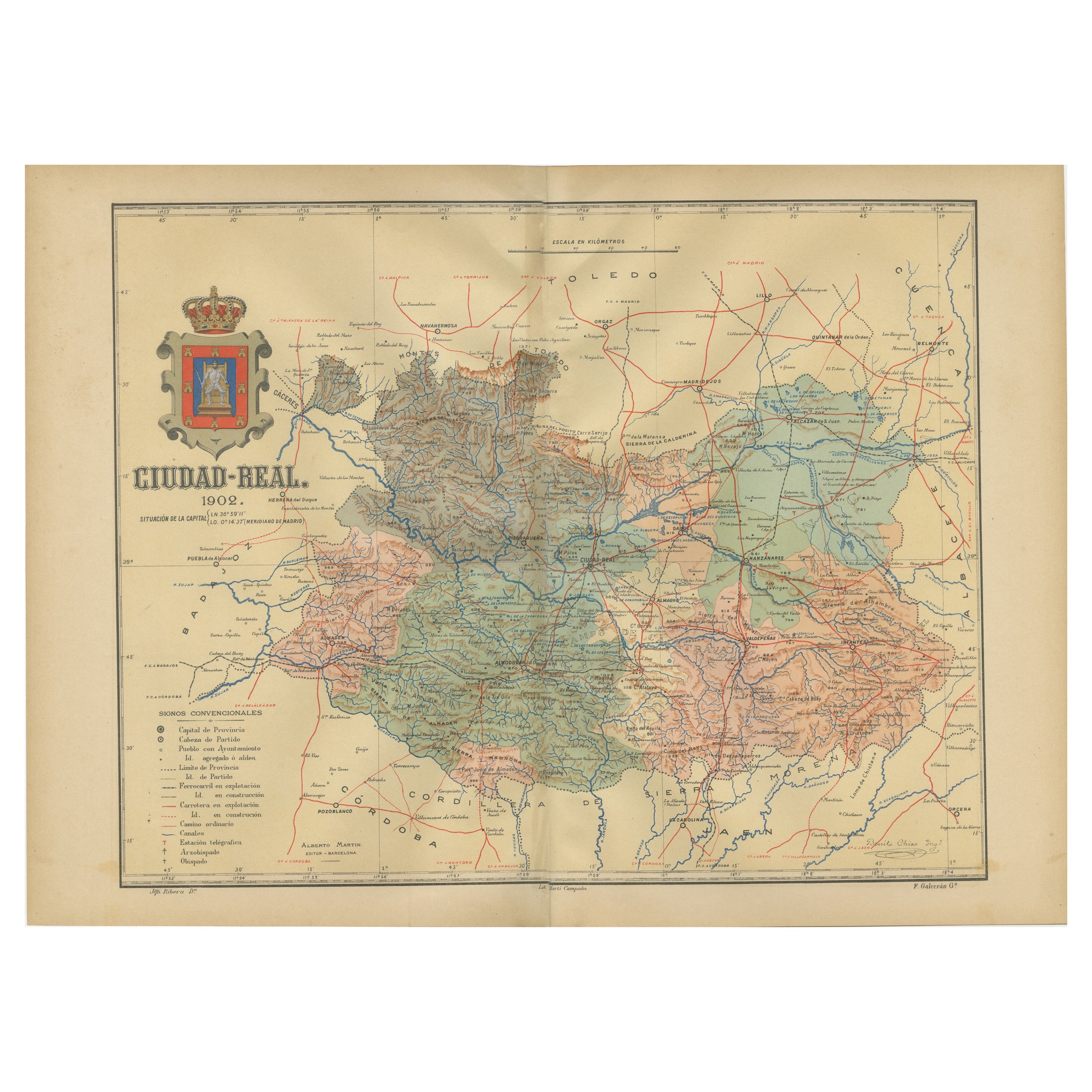
Ciudad Real 1902: A Detailed Cartographic Survey of La Mancha in Spain
Located in Langweer, NL
This original antitque map presents the province of Ciudad Real, located in the autonomous community of Castilla-La Mancha in central Spain, as of 1902. It includes several notable f...
Category
Antique Early 1900s Maps
Materials
Paper

$316 Sale Price
20% Off
Free Shipping
You May Also Like
Ancient National Atlas of France with Marengo
Located in Alessandria, Piemonte
Ancient National Atlas of France with the department of Marengo: a rare French etching dated 1806.
ST/178.
Category
Antique Early 19th Century French Other Prints
Materials
Paper

Large Original Vintage Map of Spain, circa 1920
Located in St Annes, Lancashire
Great map of Spain
Original color.
Good condition
Published by Alexander Gross
Unframed.
Category
Vintage 1920s English Maps
Materials
Paper

Original Antique English County Map, Nottinghamshire, J & C Walker, 1851
Located in St Annes, Lancashire
Great map of Nottinghamshire
Original colour
By J & C Walker
Published by Longman, Rees, Orme, Brown & Co. 1851
Unframed.
Category
Antique 1850s English Other Maps
Materials
Paper

Large 19th Century Map of France
Located in Pease pottage, West Sussex
Large 19th Century Map of France.
Remarkable condition, with a pleasing age worn patina.
Recently framed.
France Circa 1874.
Category
Antique Late 19th Century French Maps
Materials
Linen, Paper

Original Antique English County Map, Rutland, J & C Walker, 1851
Located in St Annes, Lancashire
Great map of Rutland
Original colour
By J & C Walker
Published by Longman, Rees, Orme, Brown & Co. 1851
Unframed.
Category
Antique 1850s English Other Maps
Materials
Paper

1849 Map of "Europaische Russland", 'Meyer Map of European Russia', Ric. R017
Located in Norton, MA
1849 Map of
"Europaische Russland"
( Meyer Map of European Russia)
Ric.r017
A lovely map of European Russia dating to 1849 by Joseph Meyer. It covers the European portions of...
Category
Antique 19th Century Unknown Maps
Materials
Paper

More Ways To Browse
Railway Map
Antique Oushak
Mid Century Danish Directors Chairs
Moller 70
Argentina Travel Poster
Century Furniture Faux Bamboo
Early American Chairs
Hans Muller
Vintage Wood Table With Glass Top
19th Century Square Table
Antonio Bonet
Galle Chairs
Large Chinese Rug
1940s Vintage French Art Deco
20th Century Spanish Table
Antonio Bellini
Retro Fiberglass Furniture
Shipping Crate