Items Similar to Antique Engraving of Dutch and German North Sea Coast of Friesland, ca.1680


Want more images or videos?
Request additional images or videos from the seller
1 of 6
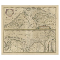
Antique Engraving of Dutch and German North Sea Coast of Friesland, ca.1680
$1,101.92
$1,377.4020% Off
£816.58
£1,020.7320% Off
€920
€1,15020% Off
CA$1,504.33
CA$1,880.4120% Off
A$1,673.51
A$2,091.8820% Off
CHF 877.27
CHF 1,096.5920% Off
MX$20,449.84
MX$25,562.3020% Off
NOK 11,170.98
NOK 13,963.7220% Off
SEK 10,515.93
SEK 13,144.9120% Off
DKK 7,004.80
DKK 8,75620% Off
Shipping
Retrieving quote...The 1stDibs Promise:
Authenticity Guarantee,
Money-Back Guarantee,
24-Hour Cancellation
About the Item
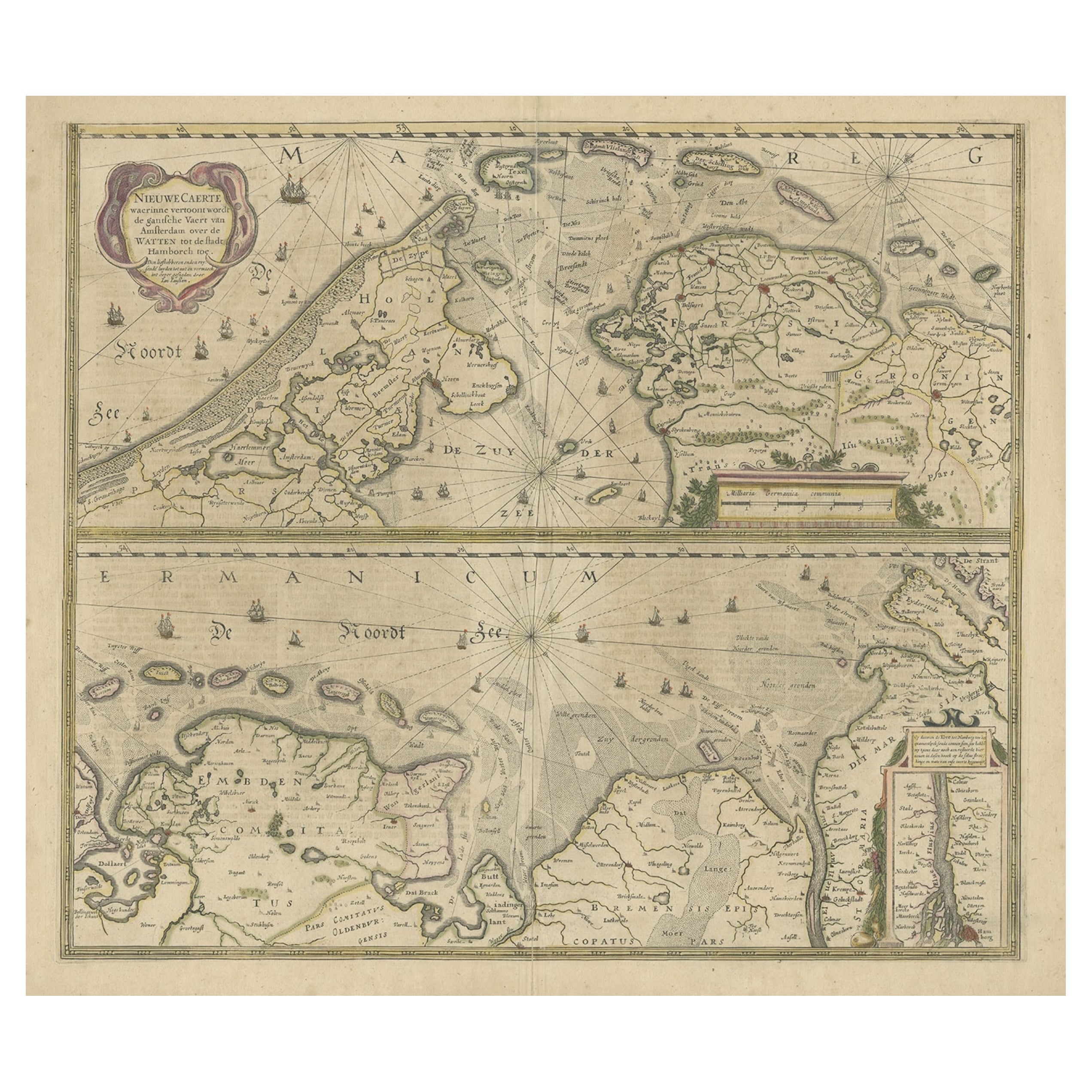
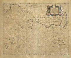
Antique map titled 'Tabula Nova In qua accuratè demonstratur tota Navigatio ab Amstelodami Statione per Vada vulgo de Watten Hamburgum usq.' -
Two maps with the Dutch and German North Sea coast of Friesland, with West Frisian Islands and below East Frisian Islands with inset map of the Elbe around Hamburg. With title and a scale cartouche. Map by Henricus Hondius, first published by J. Janssonius (1634) ´NIEUWE CAERTE waerinne vertoont wordt de gantsche Vaert van Amsterdam over de WATTEN tot de stadt Hamborch toe´, here with the name and address changed from ´The English Atlas´ published by Moses Pitt, Steven Swart and Johannes Janssonius van Waesberghen, Oxford/Amsterdam 1683.
Artists and Engravers: Publisher: Henricus Hondius
Condition: Good, given age. Edges with a few small tears. Paper separation lower middle fold; backed and not affecting image. A few minor crinkles and small creases. One tiny hole in middle fold image. Original middle fold as issued. Very wide margins. General age-related toning and/or occasional minor defects from handling. Please study scan carefully.
- Dimensions:Height: 23.43 in (59.5 cm)Width: 27.96 in (71 cm)Depth: 0 in (0.02 mm)
- Materials and Techniques:
- Period:1680-1689
- Date of Manufacture:circa 1680
- Condition:Wear consistent with age and use. Condition: Good, given age. Edges with a few small tears. Paper separation lower middle fold; backed and not affecting image. A few minor crinkles and small creases. One tiny hole in middle fold image. Original middle fold as issued.
- Seller Location:Langweer, NL
- Reference Number:Seller: PCT-57967 1stDibs: LU3054326763202
About the Seller
5.0
Recognized Seller
These prestigious sellers are industry leaders and represent the highest echelon for item quality and design.
Platinum Seller
Premium sellers with a 4.7+ rating and 24-hour response times
Established in 2009
1stDibs seller since 2017
2,494 sales on 1stDibs
Typical response time: 1 hour
- ShippingRetrieving quote...Shipping from: Langweer, Netherlands
- Return Policy
Authenticity Guarantee
In the unlikely event there’s an issue with an item’s authenticity, contact us within 1 year for a full refund. DetailsMoney-Back Guarantee
If your item is not as described, is damaged in transit, or does not arrive, contact us within 7 days for a full refund. Details24-Hour Cancellation
You have a 24-hour grace period in which to reconsider your purchase, with no questions asked.Vetted Professional Sellers
Our world-class sellers must adhere to strict standards for service and quality, maintaining the integrity of our listings.Price-Match Guarantee
If you find that a seller listed the same item for a lower price elsewhere, we’ll match it.Trusted Global Delivery
Our best-in-class carrier network provides specialized shipping options worldwide, including custom delivery.More From This Seller
View AllTwo Original Antique Engravings with the Dutch and German North Sea Coast, c1650
Located in Langweer, NL
Antique map titled 'Nieuwe Caerte waerinne vertoont wordt de gantsche Vaert van Amsterdam over de Watten tot de stadt Hamborch toe'.
Two maps with the Dutch and German North Sea ...
Category
Antique 1650s Maps
Materials
Paper
$565 Sale Price
20% Off
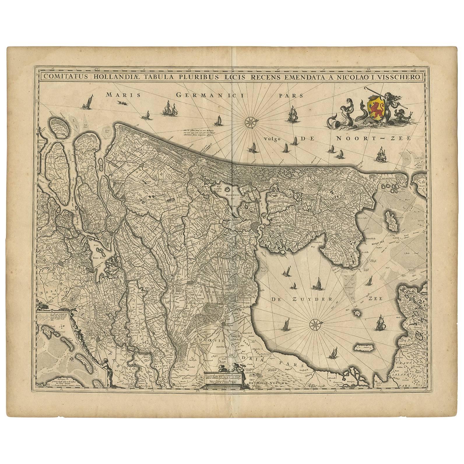
Antique Map of the Netherlands by N. Visscher, 1684
Located in Langweer, NL
Antique map titled 'Comitatus Hollandiae Tabula Pluribus Locis Recens Emendata a Nicolao I. Visschero'. West to the top. Lower left inset of the Wadden Islands, Texel, Vlieland, Ters...
Category
Antique Late 17th Century Maps
Materials
Paper

$1,054 Sale Price
20% Off
Antique Map of Friesland During Its Widest Spread, 1718
Located in Langweer, NL
Antique map Friesland titled 'Summaria descriptio Fresiae Universae (..)'. Old map of Friesland, the Netherlands. Depicts the general delineation of Friesland during its widest sprea...
Category
Antique 18th Century Maps
Materials
Paper
$210 Sale Price
20% Off
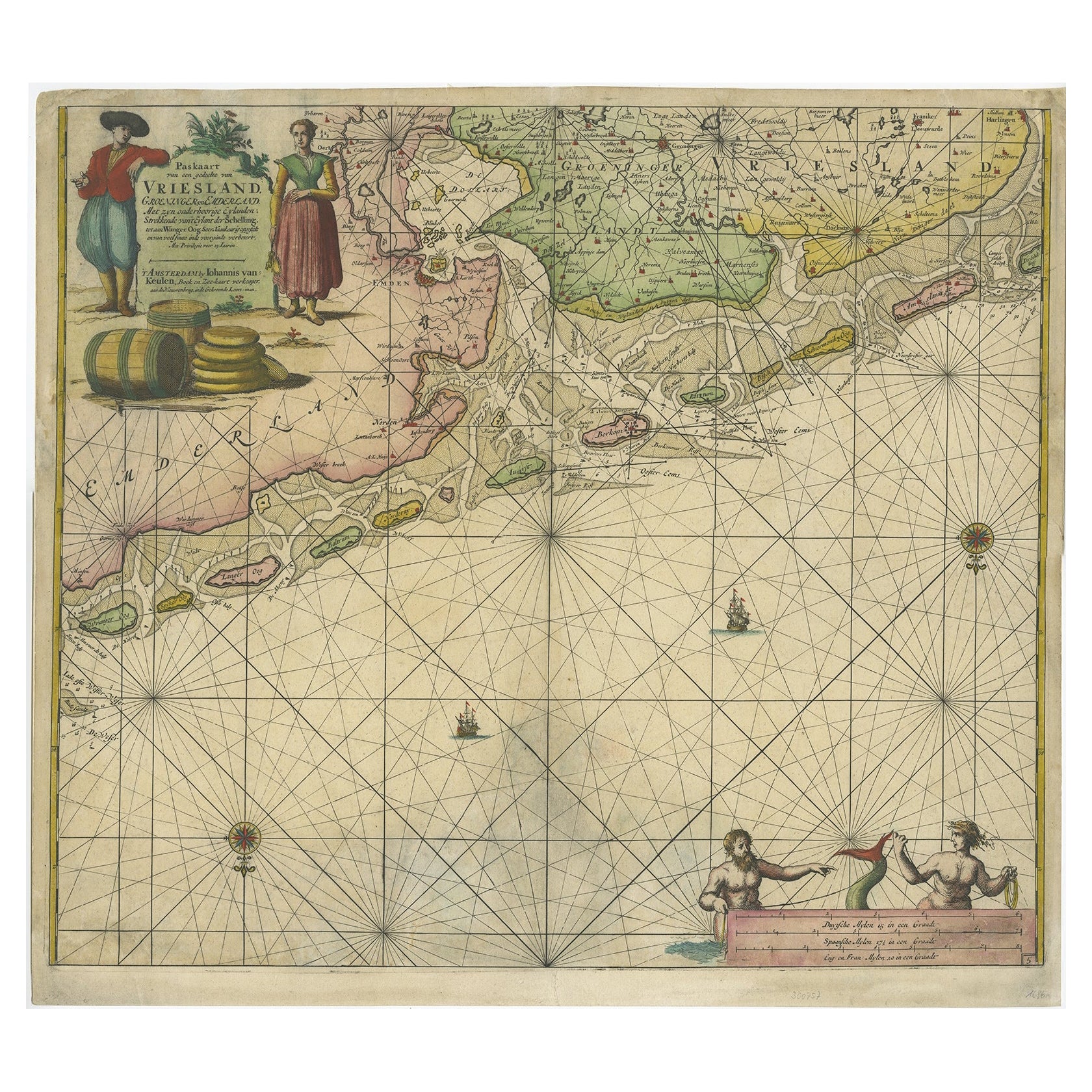
Old Decorative & Highly Detailed Sea Chart of the North Dutch-German Coast, 1681
Located in Langweer, NL
Antique map titled 'Paskaart van een gedeelte van Vriesland, Groeninger, en Emderland. Met zyn onderhoorige Eylanden; Strekkende van't Eylant der Schelling'.
Decorative and highl...
Category
Antique 1680s Maps
Materials
Paper
$1,581 Sale Price
20% Off
Antique Map: Friesland and Terschelling with Inset Isles, by Visscher II, 1670
By Nicolaes Visscher II
Located in Langweer, NL
Antique Map: Friesland and Terschelling with Inset Isles, by Nicolaas Visscher II, 1670
This large copper-engraved map provides a detailed and visually stunning depiction of the coastline of Friesland and the island of Terschelling, along with portions of Groningen to the east. Originating from Nicolaas Visscher II’s *Germania Inferiorsive XVII Provinciarum Geographicae Generalis* (Kaert-Boeck van de XVII Nederlandtsche Provincien), this map was published in Amsterdam circa 1670.
The map highlights the main cities of Friesland, beautifully accented in red, and includes a decorative inset in the lower-right corner, illustrating the smaller isles belonging to the province. The finely engraved details make this map a remarkable artifact of 17th-century cartography, with its coastline features rendered with precision and artistic flair.
Adding to its charm, the map is adorned with elaborate decorative cartouches featuring putti (cherubs) and a coat of arms, hallmark elements of Nicolaas Visscher II’s cartographic artistry. Visscher was one of the most prominent Dutch mapmakers of the Golden Age of Cartography, known for his dedication to both geographical accuracy and artistic embellishment. His maps were highly sought after during his lifetime and remain prized by collectors today.
Keywords: antique map Friesland, Terschelling map, Nicolaas Visscher II, 17th-century Dutch cartography, Groningen coastline map, decorative map cartouches, Germania Inferiorsive XVII Provinciarum, Kaert-Boeck Nederlandtsche Provincien, historical Dutch maps, rare collectible maps, Golden Age cartography.
This map is a treasure for collectors of antique cartography...
Category
Antique Late 17th Century Maps
Materials
Paper

$934 Sale Price
20% Off
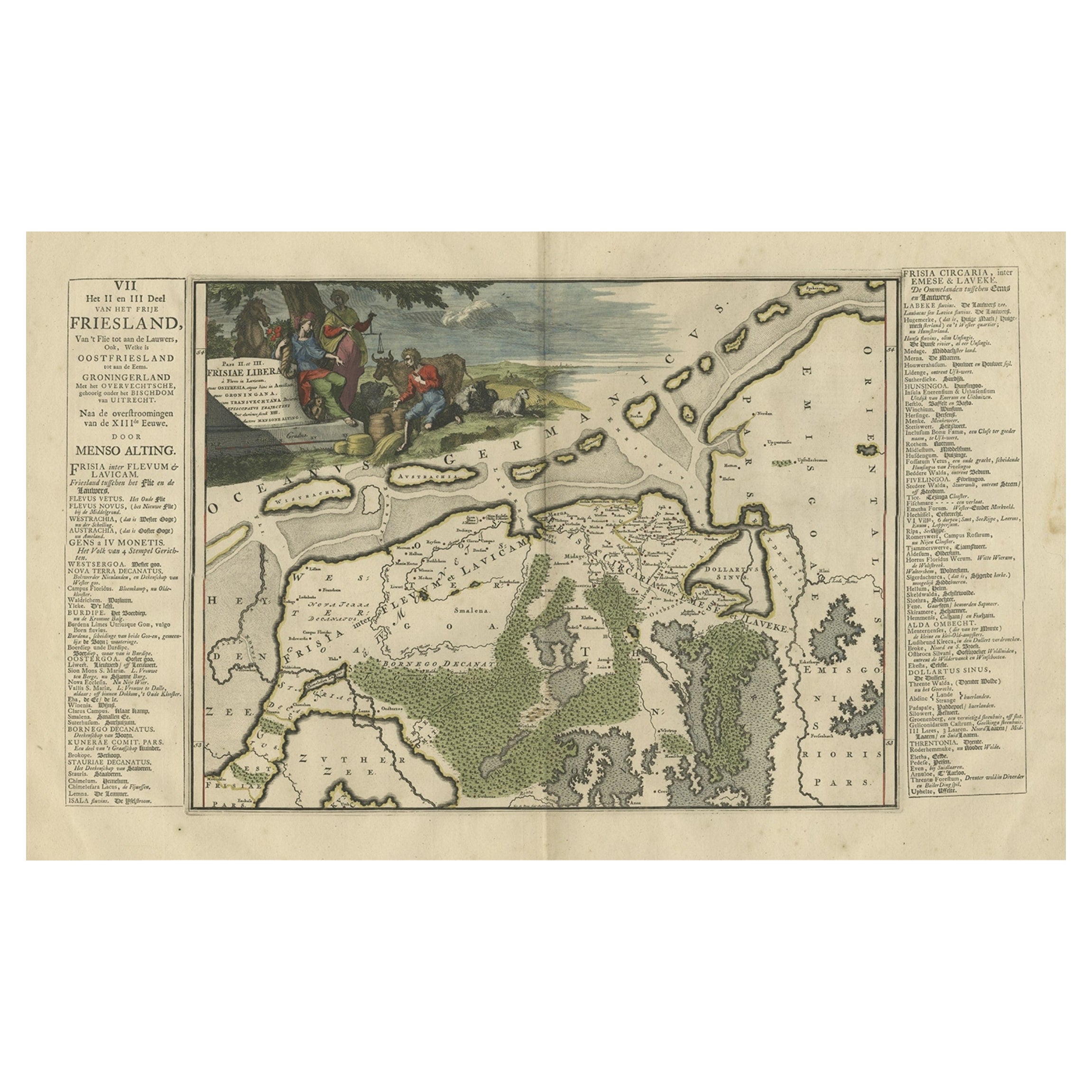
Antique Map of Friesland after the Floods of the 13th Century, 1718
Located in Langweer, NL
Antique map Friesland titled 'Pars II et III Frisiae Libera(..)'. Old map of Friesland, the Netherlands, after the floods of the 13th century. Originates from 'Uitbeelding van de Hee...
Category
Antique 18th Century Maps
Materials
Paper
$335 Sale Price
20% Off
You May Also Like
Antique Map - Mare Pacificum - Etching by Johannes Janssonius - 1650s
By Johannes Janssonius
Located in Roma, IT
Mare Pacificum is an antique map realized in 1650 by Johannes Janssonius (1588-1664).
The Map is Hand-colored etching, with coeval watercolorang.
Good conditions with slight foxing...
Category
1650s Modern Figurative Prints
Materials
Etching

Mare Atlanticum - Etching by Johannes Janssonius - 1650s
By Johannes Janssonius
Located in Roma, IT
Mare Atlanticum is an ancient map realized in 1650 by Johannes Janssonius (1588-1664).
Good conditions.
From Atlantis majoris quinta pars, Orbem maritimum [Novus Atlas, volume V: c...
Category
1650s Modern Figurative Prints
Materials
Etching
Map of the Netherlands - Etching by G. Braun and F. Hogenberg -Late 16th Century
By Franz Hogenberg
Located in Roma, IT
Map of the Netherlands is an original etching realized by George Braun and Franz Hogenberg, as part of the "Civitates Orbis Terrarum".
The “Civitates Orbis Terrarum” (Atlas of Citi...
Category
16th Century Figurative Prints
Materials
Etching

Rugen Island, Germany: An Early 17th Century Map by Mercator and Hondius
By Gerard Mercator
Located in Alamo, CA
This is an early 17th century map entitled "Nova Famigerabilis Insulae Ac Ducatus Rugiae Desciptio" (Map of Rugen Island, Germany) by Gerard Mercator and Henricus and Joducus Hondiu...
Category
Early 17th Century Old Masters Landscape Prints
Materials
Engraving

Antique Map - Gallia - Etching by Johannes Janssonius - 1650s
By Johannes Janssonius
Located in Roma, IT
Antique Map - Gallia is an antique map realized in 1650 by Johannes Janssonius (1588-1664).
The Map is Hand-colored etching, with coeval watercoloring.
Good conditions with slight ...
Category
1650s Modern Figurative Prints
Materials
Etching

North Holland, Netherlands: A Large 17th C. Hand-colored Map by Sanson & Jaillot
By Nicholas Sanson d'Abbeville
Located in Alamo, CA
This large hand-colored map entitled "Le Comte De Hollande Dressee sur les Memoires les plus Nouveaux" was originally created by Nicholas Sanson d'Abbeville. This version was publish...
Category
1690s Landscape Prints
Materials
Engraving

More Ways To Browse
Antique Navigational Tools
Antique German Compass
Key Trade Sign
Spanish Galleon
World Map Of Trade Routes
Antique Puerto Rico
Albanian Antique
Antique Furniture Wiltshire
Antique Maps Of Israel
Framed Africa Maps
Antique Furniture Goa
Croatian Antiques
Map Of Israel
Teak Sphere
18th Century Scottish Collectibles
Map Of Mexican California
Ottoman Map
Antique Map Of Korea