Items Similar to Antique Map of Alentejo: Land of Tradition and Tranquility, 1903

Want more images or videos?
Request additional images or videos from the seller
1 of 7
Antique Map of Alentejo: Land of Tradition and Tranquility, 1903
$374.14
$467.6820% Off
£278.33
£347.9120% Off
€312
€39020% Off
CA$512.33
CA$640.4120% Off
A$569.64
A$712.0520% Off
CHF 297.44
CHF 371.7920% Off
MX$6,933.93
MX$8,667.4220% Off
NOK 3,795.15
NOK 4,743.9420% Off
SEK 3,555.87
SEK 4,444.8420% Off
DKK 2,375.08
DKK 2,968.8520% Off
Shipping
Retrieving quote...The 1stDibs Promise:
Authenticity Guarantee,
Money-Back Guarantee,
24-Hour Cancellation
About the Item
The image is a historical original antique map of the Alentejo region in Portugal. This map includes the topographical layout of the region, with its complex network of roads and waterways, and features the city of Évora, which seems to be highlighted as an important location. The Alentejo is known for its rolling landscapes, vineyards, olive groves, and rich history, including numerous prehistoric and Roman sites. Évora itself is a UNESCO World Heritage site, known for its well-preserved old town center, Roman temple, and chapel of bones.
The map also includes the coats of arms of Beja and Évora, suggesting the map's focus on the administrative divisions within Alentejo. The region's vast plains, cork production, and historical significance are some of the key characteristics that would be of interest in a catalogue or guide.
The Alentejo region, encompassing a considerable portion of central and southern Portugal, is notable for several distinctive characteristics:
1. **Cultural Heritage**: Alentejo is home to a rich array of cultural landmarks. The historic center of Évora, a UNESCO World Heritage Site, is a treasure trove of history, featuring a Roman temple, medieval walls, and a 16th-century aqueduct.
2. **Agriculture**: The region is known for its extensive olive groves and vineyards, producing high-quality olive oil and wines. It's also a major producer of cork, with vast cork oak forests that are sustainably harvested.
3. **Cuisine**: Alentejo's culinary tradition is robust and flavorsome, with dishes like açorda (bread-based dish with garlic, cilantro, eggs, and olive oil), and carne de porco à alentejana (pork with clams).
4. **Landscapes**: The area is characterized by rolling plains, which in spring are covered with a blanket of wildflowers. The Alqueva Dam has created a large artificial lake, offering recreational activities and beautiful scenery.
5. **Prehistoric Sites**: Alentejo is rich in prehistoric remains, including the Cromeleque dos Almendres, one of the largest groups of structured menhirs in Europe.
6. **Architecture**: The region's architecture is marked by white-washed houses, historic castles, and Roman ruins, providing a picturesque setting that reflects its history.
7. **Tranquility**: Alentejo is less densely populated than other regions in Portugal, offering a sense of tranquility and an escape from the hustle and bustle of city life.
8. **Coastline**: The Alentejo coast boasts some of the most pristine and least crowded beaches in Portugal, with dramatic cliffs and clear waters.
9. **Music and Dance**: Traditional Alentejo music, particularly the Cante Alentejano, a form of polyphonic singing, is recognized by UNESCO as an Intangible Cultural Heritage.
These elements make Alentejo a region of serene beauty, deep historical roots, and rich cultural expressions.
- Dimensions:Height: 20.08 in (51 cm)Width: 14.77 in (37.5 cm)Depth: 0 in (0.02 mm)
- Materials and Techniques:
- Period:1900-1909
- Date of Manufacture:1903
- Condition:Good condition. Central vertical folding lines as issued. Aged paper with typically warm, yellowish-brown hue, especially around the edges and folding lines, adding to its patina. Check the images carefully.
- Seller Location:Langweer, NL
- Reference Number:Seller: BG-13642-541stDibs: LU3054338034522
About the Seller
5.0
Recognized Seller
These prestigious sellers are industry leaders and represent the highest echelon for item quality and design.
Platinum Seller
Premium sellers with a 4.7+ rating and 24-hour response times
Established in 2009
1stDibs seller since 2017
2,510 sales on 1stDibs
Typical response time: <1 hour
- ShippingRetrieving quote...Shipping from: Langweer, Netherlands
- Return Policy
Authenticity Guarantee
In the unlikely event there’s an issue with an item’s authenticity, contact us within 1 year for a full refund. DetailsMoney-Back Guarantee
If your item is not as described, is damaged in transit, or does not arrive, contact us within 7 days for a full refund. Details24-Hour Cancellation
You have a 24-hour grace period in which to reconsider your purchase, with no questions asked.Vetted Professional Sellers
Our world-class sellers must adhere to strict standards for service and quality, maintaining the integrity of our listings.Price-Match Guarantee
If you find that a seller listed the same item for a lower price elsewhere, we’ll match it.Trusted Global Delivery
Our best-in-class carrier network provides specialized shipping options worldwide, including custom delivery.More From This Seller
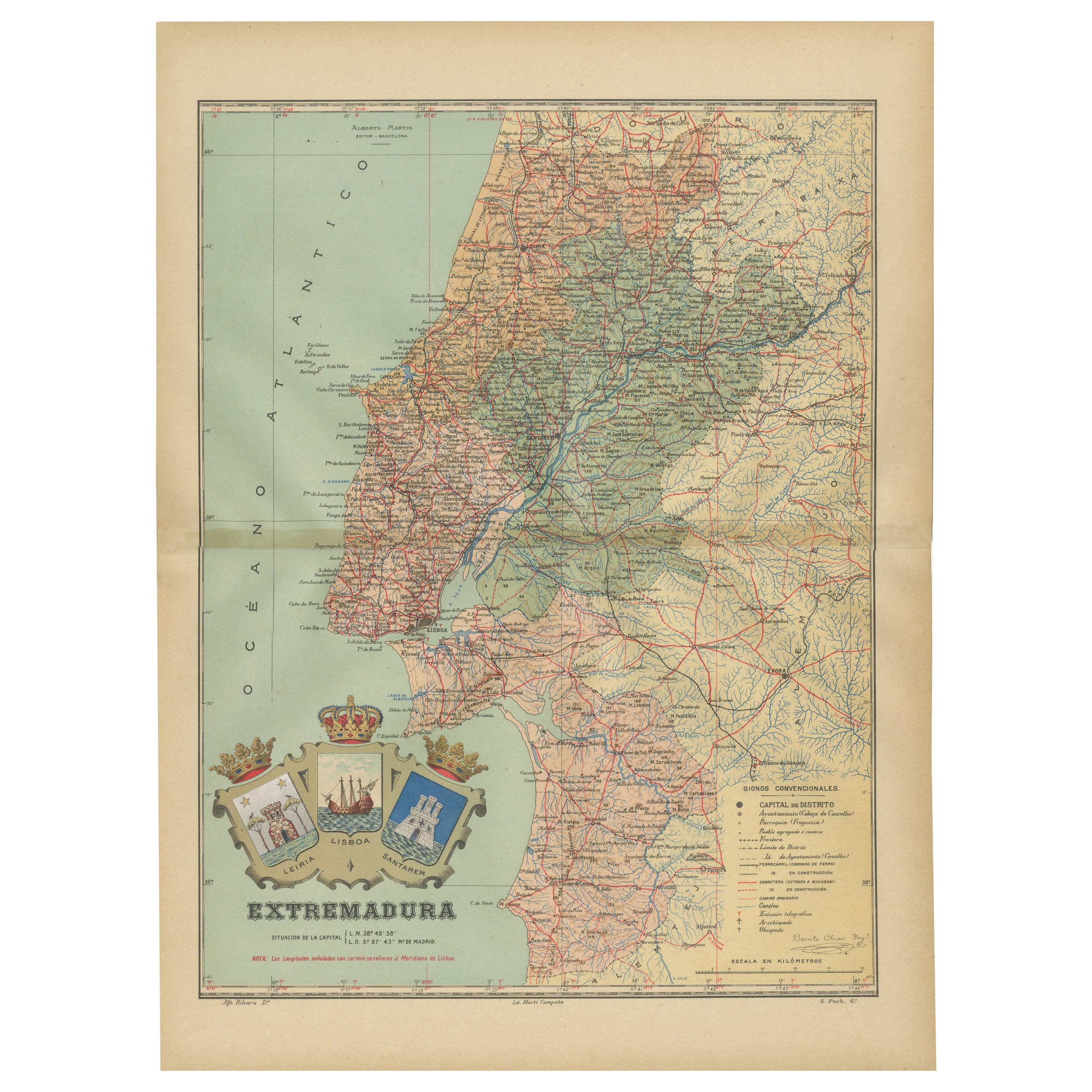
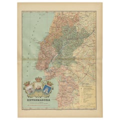
View AllAn Antique Map of Extremadura: Crossroads of History and Nature, 1903
Located in Langweer, NL
The image is a historical map of Extremadura, an autonomous community of Spain, from an unspecified year. The map features the region's topography, including mountain ranges, river systems, and road networks. Extremadura is bordered by Portugal to the west and is situated to the southwest of Madrid. The map also includes the coat of arms of Lisbon (Lisboa), possibly indicating the historical connections between the two regions, as Lisbon is close to the border of Extremadura.
Extremadura is known for its:
1. **Natural Landscapes**: The region has diverse landscapes, including the mountainous areas in the north and the fertile plains (known as the dehesa) used for grazing pigs, which produce the famous Iberian ham.
2. **Historical Significance**: Extremadura was the birthplace of many famous conquistadors, such as Hernán Cortés...
Category
Antique Early 1900s Maps
Materials
Paper
$441 Sale Price
20% Off
Free Shipping
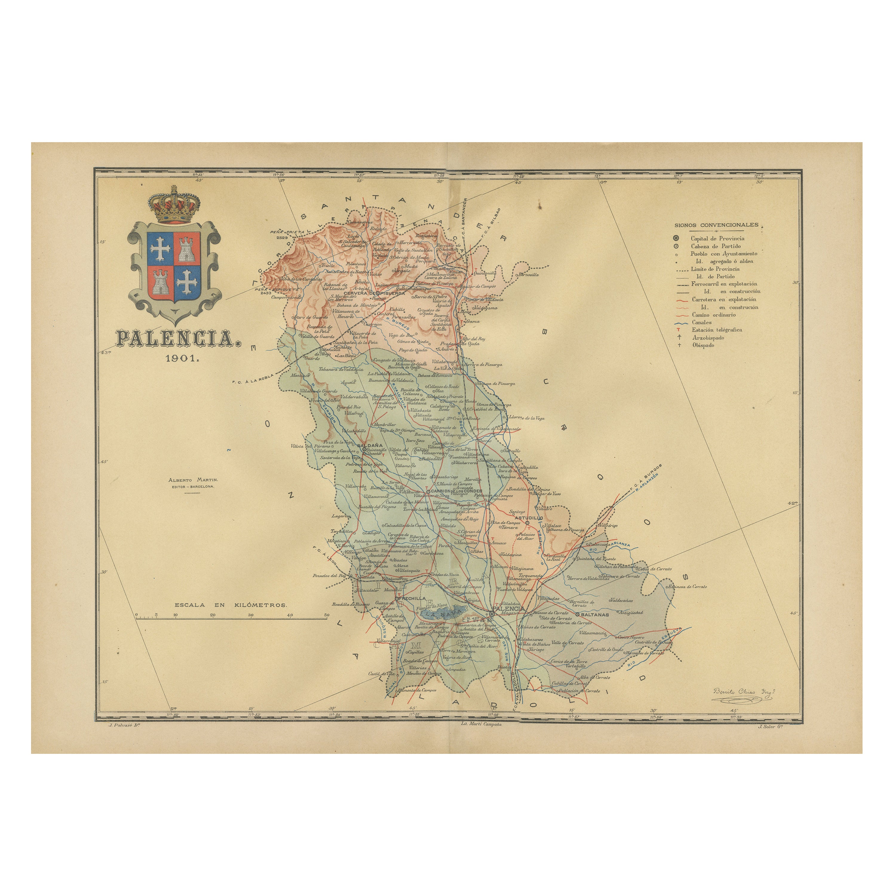
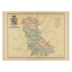
Original Antique Map of Palencia Province, in Northern Spain, 1901
Located in Langweer, NL
This historical map is of Palencia, a province in the northern part of Spain.
Palencia is situated within the autonomous community of Castilla y León. It is bordered by the provinc...
Category
Antique Early 1900s Maps
Materials
Paper
$374 Sale Price
20% Off
Free Shipping
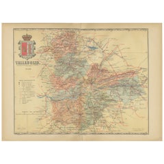
Anrtique Map of the Province of Valladolid, Central Spain, 1902
Located in Langweer, NL
A historical or archival map of the province of Valladolid, Spain, from the year 1902. Valladolid is a province located in the central part of Spain, within the autonomous community ...
Category
Antique Early 1900s Maps
Materials
Paper
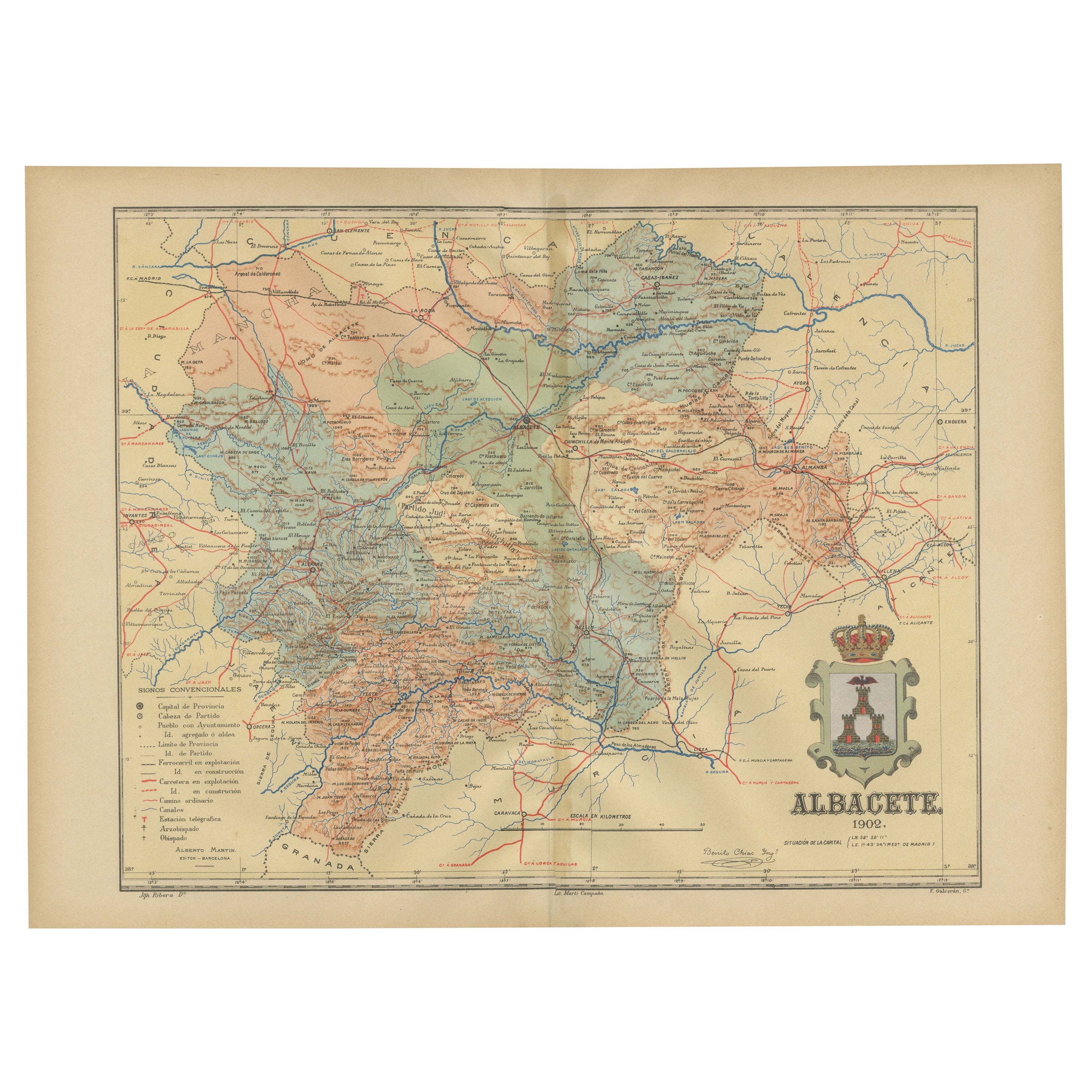
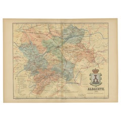
Albacete, Spain - 1902: A Cartographic Depiction of Landscape and Infrastructure
Located in Langweer, NL
Albacete, Spain - 1902: A Cartographic Depiction of Landscape and Infrastructure
An original and historical map of the province of Albacete, dated 1902, from the "Atlas Geográfico I...
Category
Antique Early 1900s Maps
Materials
Paper
$278 Sale Price
20% Off
Free Shipping
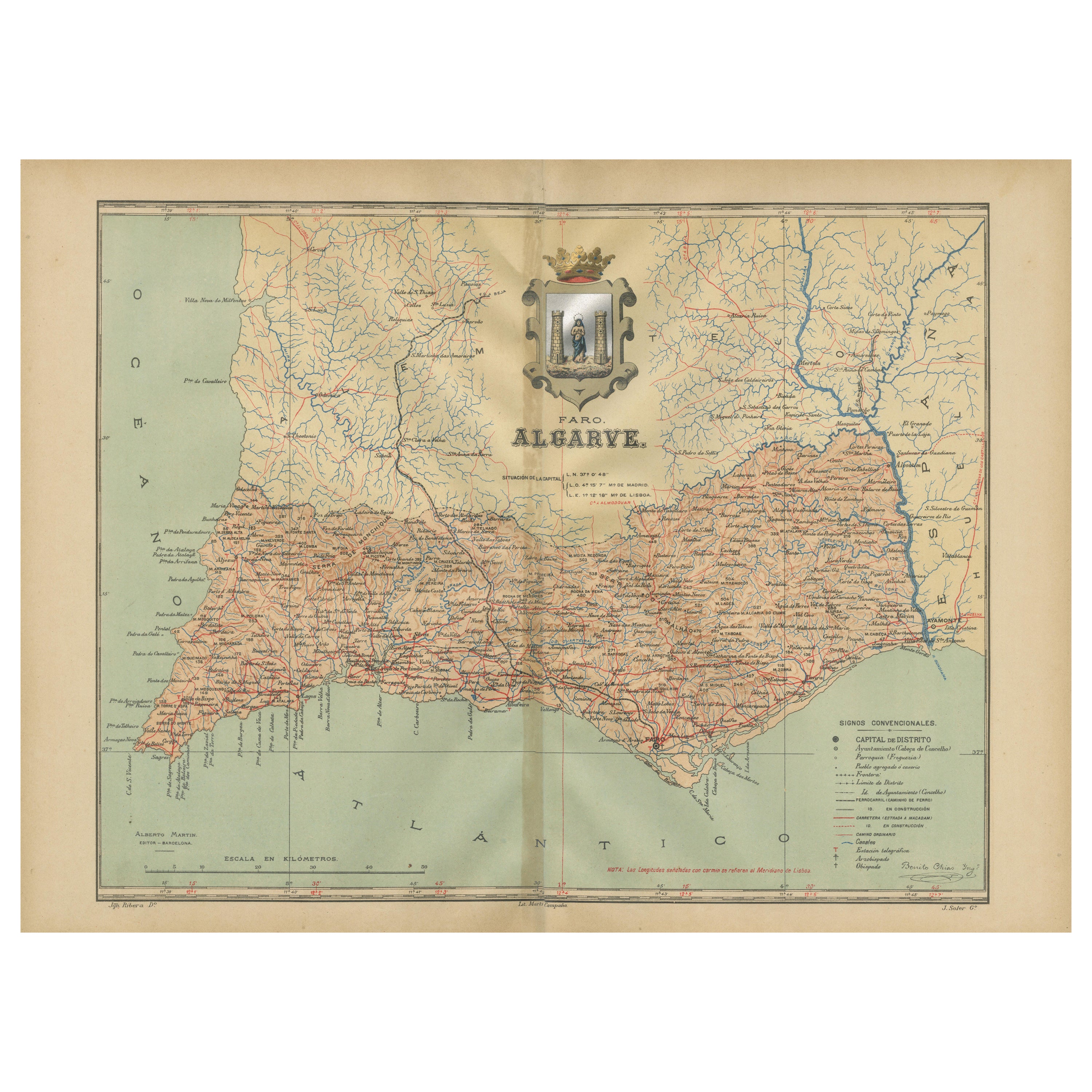
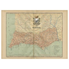
Algarve: A Tapestry of Sea and Sunlight in an Antique Map, 1903
Located in Langweer, NL
The image is a historical map of the Algarve, the southernmost region of Portugal. The map is titled "FARO. ALGARVE," indicating that it is centered around the city of Faro, which is...
Category
Antique Early 1900s Maps
Materials
Paper
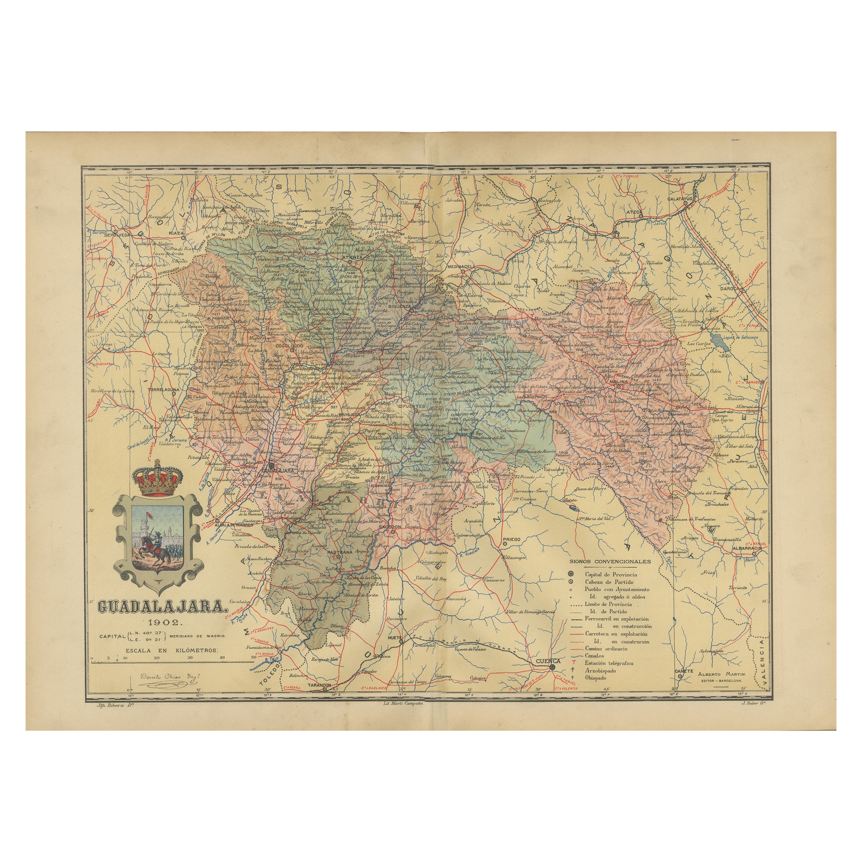
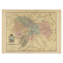
Guadalajara 1902: A Cartographic Image of Castilla-La Mancha's Northern Province
Located in Langweer, NL
The map illustrates the province of Guadalajara, part of the autonomous community of Castilla-La Mancha in Spain, as of 1902. The map includes various geographic and infrastructural ...
Category
Antique Early 1900s Maps
Materials
Paper
$278 Sale Price
20% Off
Free Shipping
You May Also Like
Original Antique English County Map, Nottinghamshire, J & C Walker, 1851
Located in St Annes, Lancashire
Great map of Nottinghamshire
Original colour
By J & C Walker
Published by Longman, Rees, Orme, Brown & Co. 1851
Unframed.
Category
Antique 1850s English Other Maps
Materials
Paper

Large Original Vintage Map of Spain, circa 1920
Located in St Annes, Lancashire
Great map of Spain
Original color.
Good condition
Published by Alexander Gross
Unframed.
Category
Vintage 1920s English Maps
Materials
Paper

Original Antique English County Map, Rutland, J & C Walker, 1851
Located in St Annes, Lancashire
Great map of Rutland
Original colour
By J & C Walker
Published by Longman, Rees, Orme, Brown & Co. 1851
Unframed.
Category
Antique 1850s English Other Maps
Materials
Paper

Original Antique English County Map, Derbyshire, J & C Walker, 1851
Located in St Annes, Lancashire
Great map of Derbyshire
Original colour
By J & C Walker
Published by Longman, Rees, Orme, Brown & Co. 1851
Unframed.
Category
Antique 1850s English Other Maps
Materials
Paper

Original Antique English County Map, Leicestershire, J & C Walker, 1851
Located in St Annes, Lancashire
Great map of Leicestershire
Original colour
By J & C Walker
Published by Longman, Rees, Orme, Brown & Co. 1851
Unframed.
Category
Antique 1850s English Other Maps
Materials
Paper

1849 Map of "Europaische Russland", 'Meyer Map of European Russia', Ric. R017
Located in Norton, MA
1849 Map of
"Europaische Russland"
( Meyer Map of European Russia)
Ric.r017
A lovely map of European Russia dating to 1849 by Joseph Meyer. It covers the European portions of...
Category
Antique 19th Century Unknown Maps
Materials
Paper

More Ways To Browse
Roman Temple
Large Wall Maps
Oliver Arms
Harvest Oak
Used Harvest House Furniture
Olive Dish
Antique Wine Corks
Clam Dish
Antique Egg Dish
Antique Egg Dishes
Early American Chairs
Hans Muller
Vintage Wood Table With Glass Top
19th Century Square Table
Antonio Bonet
Galle Chairs
Large Chinese Rug
1940s Vintage French Art Deco