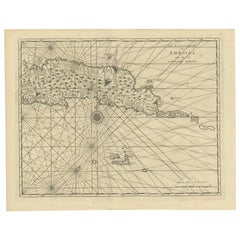
Items Similar to Antique Map of Anjouan Island by Valentijn, 1726


Want more images or videos?
Request additional images or videos from the seller
1 of 5
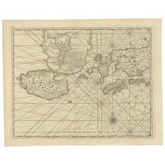
Antique Map of Anjouan Island by Valentijn, 1726
$568.93
£421.61
€475
CA$776.69
A$864.04
CHF 452.94
MX$10,558.34
NOK 5,767.63
SEK 5,429.42
DKK 3,616.61
Shipping
Retrieving quote...The 1stDibs Promise:
Authenticity Guarantee,
Money-Back Guarantee,
24-Hour Cancellation
About the Item
Antique map titled 'Anzuany'. This map depicts the island of Anjouan, one of the Comoros islands situated between Madagascar and Africa. The map is oriented with north to the left with the King's Palace shown upside down, and several mountains and forested areas inland. This map originates from 'Oud en Nieuw Oost-Indiën' by F. Valentijn.
- Creator:F. Valentijn (Artist)
- Dimensions:Height: 13.19 in (33.5 cm)Width: 8.08 in (20.5 cm)Depth: 0.02 in (0.5 mm)
- Place of Origin:
- Period:
- Date of Manufacture:1726
- Condition:Wear consistent with age and use. General age-related toning and minor foxing. Please study images carefully.
- Seller Location:Langweer, NL
- Reference Number:Seller: BGRN-0111stDibs: LU3054313437142
About the Seller
5.0
Recognized Seller
These prestigious sellers are industry leaders and represent the highest echelon for item quality and design.
Platinum Seller
Premium sellers with a 4.7+ rating and 24-hour response times
Established in 2009
1stDibs seller since 2017
2,494 sales on 1stDibs
Typical response time: 1 hour
- ShippingRetrieving quote...Shipping from: Langweer, Netherlands
- Return Policy
Authenticity Guarantee
In the unlikely event there’s an issue with an item’s authenticity, contact us within 1 year for a full refund. DetailsMoney-Back Guarantee
If your item is not as described, is damaged in transit, or does not arrive, contact us within 7 days for a full refund. Details24-Hour Cancellation
You have a 24-hour grace period in which to reconsider your purchase, with no questions asked.Vetted Professional Sellers
Our world-class sellers must adhere to strict standards for service and quality, maintaining the integrity of our listings.Price-Match Guarantee
If you find that a seller listed the same item for a lower price elsewhere, we’ll match it.Trusted Global Delivery
Our best-in-class carrier network provides specialized shipping options worldwide, including custom delivery.More From This Seller
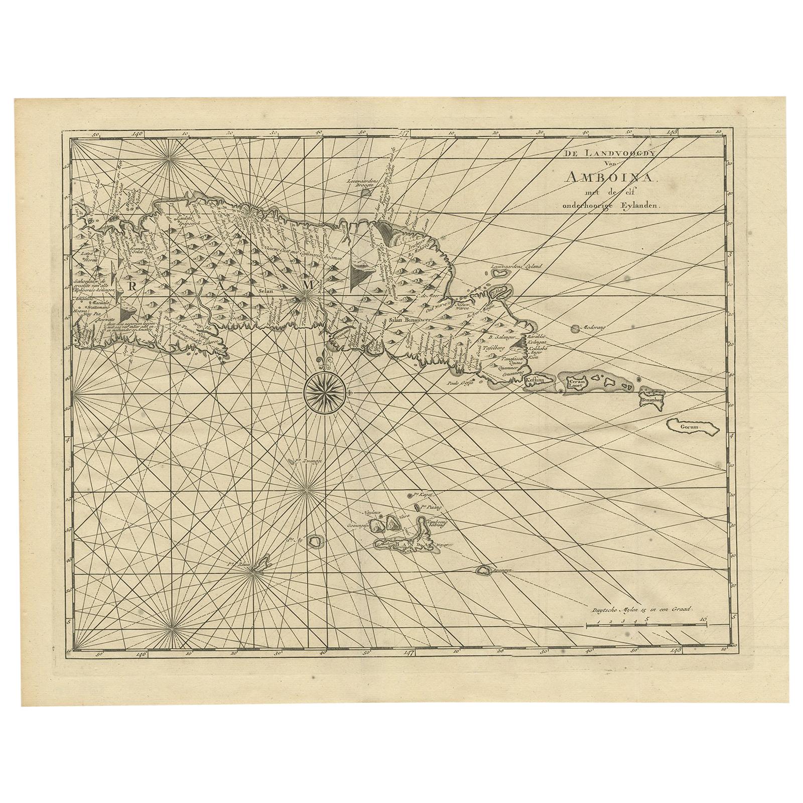
View AllAntique Map of Ambon and Surroundings by Valentijn '1726'
By F. Valentijn
Located in Langweer, NL
Antique map titled 'De landvoogdy van Amboina met de elf onderhoorige Eylanden'. Decorative map of the eastern tip of the islands of Ambon, Indonesia. This print originates from 'Oud...
Category
Antique Early 18th Century Dutch Maps
Materials
Paper
$527 Sale Price
20% Off
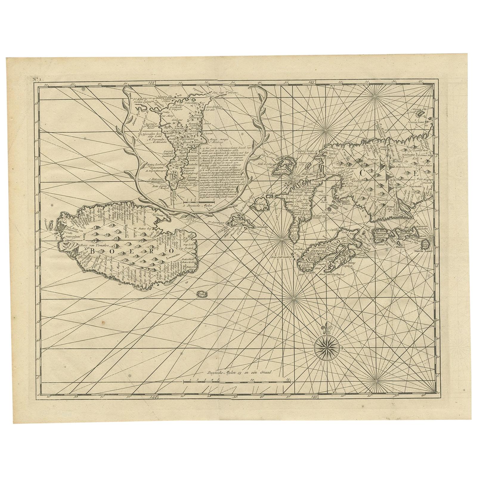
Antique Map of Ambon and Boero by Valentijn, 1726
By F. Valentijn
Located in Langweer, NL
Untitled map of the western part of the island Amboina with Boero, Indonesia. This print originates from 'Oud en Nieuw Oost-Indiën' by F. Valentijn.
Category
Antique Early 18th Century Dutch Maps
Materials
Paper
$479 Sale Price
20% Off
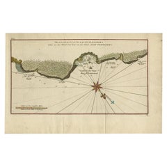
Antique Map of Juan Fernandez Island by Anson '1749'
Located in Langweer, NL
Antique map titled 'l'Ile de Juan Fernandes dans la Mer du Sud (..) - Het Eiland Juan Fernandes in de Zuid Zee (..)'. This map depicts Juan Fernandez Island in the Southern Sea. This...
Category
Antique Mid-18th Century Maps
Materials
Paper

$192 Sale Price
20% Off
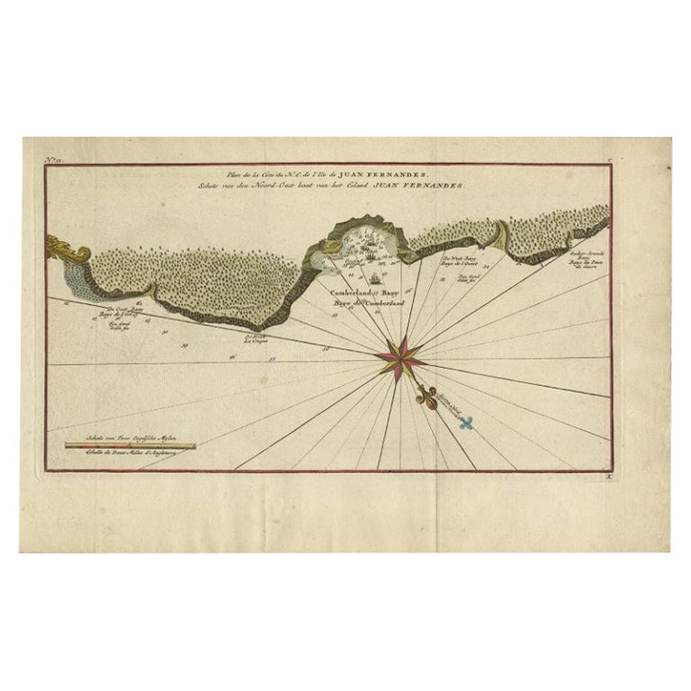
Antique Map of Juan Fernandez Island by Anson, c.1740
Located in Langweer, NL
Antique map titled 'Plan de la Côte du N.E. de l 'Ile de Juan Fernandes'.
Map of the northeast coast of the island of Juan Fernandez with Cumberland Bay, South America. In 1740 Ans...
Category
Antique 18th Century Maps
Materials
Paper

$230 Sale Price
20% Off
Juan Fernandez Island Map – Antique Chilean Chart circa 1750
Located in Langweer, NL
Antique map titled 'Plan de la Côte du N.E. de l 'Ile de Juan Fernandes'.
Map of the northeast coast of the island of Juan Fernandez with Cumberland Bay, South America. In 1740 Ans...
Category
Antique 18th Century Maps
Materials
Paper
$335 Sale Price
20% Off
Antique Map of the Maluku Islands by Van der Aa, 1714
By Pieter Van Der Aa
Located in Langweer, NL
Antique Map Moluccas titled 'Les Isles Moluques'. Rare map of the Spice Islands made after a map engraved by Pieter van den Keere and published in the 1628 edition of the Mercator At...
Category
Antique 18th Century Maps
Materials
Paper

$190 Sale Price
20% Off
You May Also Like
Antique Map - Gallia - Etching by Johannes Janssonius - 1650s
By Johannes Janssonius
Located in Roma, IT
Antique Map - Gallia is an antique map realized in 1650 by Johannes Janssonius (1588-1664).
The Map is Hand-colored etching, with coeval watercoloring.
Good conditions with slight ...
Category
1650s Modern Figurative Prints
Materials
Etching

West Coast of Africa, Guinea & Sierra Leone: An 18th Century Map by Bellin
By Jacques-Nicolas Bellin
Located in Alamo, CA
Jacques Bellin's copper-plate map entitled "Partie de la Coste de Guinee Dupuis la Riviere de Sierra Leona Jusquau Cap das Palmas", depicting the coast of Guinea and Sierra Leone in ...
Category
Antique Mid-18th Century French Maps
Materials
Paper

Ancient Map - Zeilan - Etching by Johannes Janssonius - 1650s
By Johannes Janssonius
Located in Roma, IT
Ancient Map - Zeilan is an ancient map realized in 1650 by Johannes Janssonius (1588-1664).
The Map is Hand-colored etching, with coeval watercoloring.
...
Category
1650s Modern Figurative Prints
Materials
Etching

Antique Map - Mare Pacificum - Etching by Johannes Janssonius - 1650s
By Johannes Janssonius
Located in Roma, IT
Mare Pacificum is an antique map realized in 1650 by Johannes Janssonius (1588-1664).
The Map is Hand-colored etching, with coeval watercolorang.
Good conditions with slight foxing...
Category
1650s Modern Figurative Prints
Materials
Etching

St. Christophe 'St. Kitts' Island: An 18th Century Hand-colored Map by Bellin
By Jacques-Nicolas Bellin
Located in Alamo, CA
Jacques Bellin's copper-plate map of the Caribbean island of Saint Kitts entitled "Carte De De l'Isle St. Christophe Pour servir á l'Histoire Genle. des V...
Category
Antique Mid-18th Century French Maps
Materials
Paper

1627 Hendrik Hondius Map Entitled "Vltoniae Orientalis Pars, " Ric.a009
Located in Norton, MA
1627 Hendrik Hondius map entitled
"Vltoniae orientalis pars,"
Ric.a009
Title:
Vltoniae orientalis : pars
Title (alt.) :
Ultoniae orientalis pars
Creator:
Mercator, Gerh...
Category
Antique 17th Century Dutch Maps
Materials
Paper

More Ways To Browse
Map Of Madagascar
London Antique Maps
Antique Map Of England
Gold Maps
China Map
17th Century World Map
Antique Maps Of Britain
Antique Furniture Edinburgh
Antique English Maps
Map Of India
British Empire Furniture
American West Antiques
Furniture Russian 18th Century
Antique Law Office Furniture
Map Stand
Antique Maps Of Italy
Antique Doctors
Antique Map India