Items Similar to Antique Map of Celtic Europe by Cluver, 1678


Want more images or videos?
Request additional images or videos from the seller
1 of 5
Antique Map of Celtic Europe by Cluver, 1678
$287.55
$359.4420% Off
£214.07
£267.5820% Off
€240
€30020% Off
CA$393.88
CA$492.3520% Off
A$438.08
A$547.6020% Off
CHF 228.75
CHF 285.9420% Off
MX$5,330.94
MX$6,663.6820% Off
NOK 2,921.50
NOK 3,651.8720% Off
SEK 2,739.85
SEK 3,424.8120% Off
DKK 1,827.04
DKK 2,283.8020% Off
Shipping
Retrieving quote...The 1stDibs Promise:
Authenticity Guarantee,
Money-Back Guarantee,
24-Hour Cancellation
About the Item
Antique map Europe titled 'Europam sive Celticam Veterem'. Rare map of Celtic Europe. Made after A. Ortelius, originates from 'Introductionis in universam geographicarum' by P. Cluver.
Artists and Engravers: Published by J. Duncker.
Condition: Very good, general age-related toning. Please study image carefully.
Date: 1678
Overall size: 28.5 x 22 cm.
Image size: 20.5 x 15.5 cm.
We sell original antique maps to collectors, historians, educators and interior decorators all over the world. Our collection includes a wide range of authentic antique maps from the 16th to the 20th centuries. Buying and collecting antique maps is a tradition that goes back hundreds of years. Antique maps have proved a richly rewarding investment over the past decade, thanks to a growing appreciation of their unique historical appeal. Today the decorative qualities of antique maps are widely recognized by interior designers who appreciate their beauty and design flexibility. Depending on the individual map, presentation, and context, a rare or antique map can be modern, traditional, abstract, figurative, serious or whimsical. We offer a wide range of authentic antique maps for any budget.
- Dimensions:Height: 8.67 in (22 cm)Width: 11.23 in (28.5 cm)Depth: 0 in (0.01 mm)
- Materials and Techniques:
- Period:
- Date of Manufacture:1678
- Condition:
- Seller Location:Langweer, NL
- Reference Number:Seller: BG-093121stDibs: LU3054326085202
About the Seller
5.0
Recognized Seller
These prestigious sellers are industry leaders and represent the highest echelon for item quality and design.
Platinum Seller
Premium sellers with a 4.7+ rating and 24-hour response times
Established in 2009
1stDibs seller since 2017
2,510 sales on 1stDibs
Typical response time: <1 hour
- ShippingRetrieving quote...Shipping from: Langweer, Netherlands
- Return Policy
Authenticity Guarantee
In the unlikely event there’s an issue with an item’s authenticity, contact us within 1 year for a full refund. DetailsMoney-Back Guarantee
If your item is not as described, is damaged in transit, or does not arrive, contact us within 7 days for a full refund. Details24-Hour Cancellation
You have a 24-hour grace period in which to reconsider your purchase, with no questions asked.Vetted Professional Sellers
Our world-class sellers must adhere to strict standards for service and quality, maintaining the integrity of our listings.Price-Match Guarantee
If you find that a seller listed the same item for a lower price elsewhere, we’ll match it.Trusted Global Delivery
Our best-in-class carrier network provides specialized shipping options worldwide, including custom delivery.More From This Seller
View AllAntique Map of the British Isles and Part of Europe by Chatelain, c.1720
Located in Langweer, NL
Antique map titled 'Carte pour l'Intelligence de l'Histoire d'Angleterre (..)'. Decorative map showing the British Isles and the various regions conquered in Europe. Includese two elaborate family trees for the House of York...
Category
Antique 18th Century Maps
Materials
Paper
Antique Map of Europe Stretching from Northern Africa to the Baltic Sea, 1719
Located in Langweer, NL
Antique map titled 'Carte de la Germanie et les diferents Etats ou ses Peuples ont porté leurs conquestes'. Original antique map of Europe stretching from northern Africa to the Balt...
Category
Antique 18th Century Maps
Materials
Paper

$460 Sale Price
20% Off
Antique Map of Europe by R. Bonne, 1780
Located in Langweer, NL
A fine example of Rigobert Bonne and Guilleme Raynal’s 1780 map of Europe. Drawn by R. Bonne for G. Raynal’s Atlas de Toutes les Parties Connues du Globe Terrestre, Dressé pour l'His...
Category
Antique Late 18th Century French Maps
Materials
Paper

$150 Sale Price
30% Off
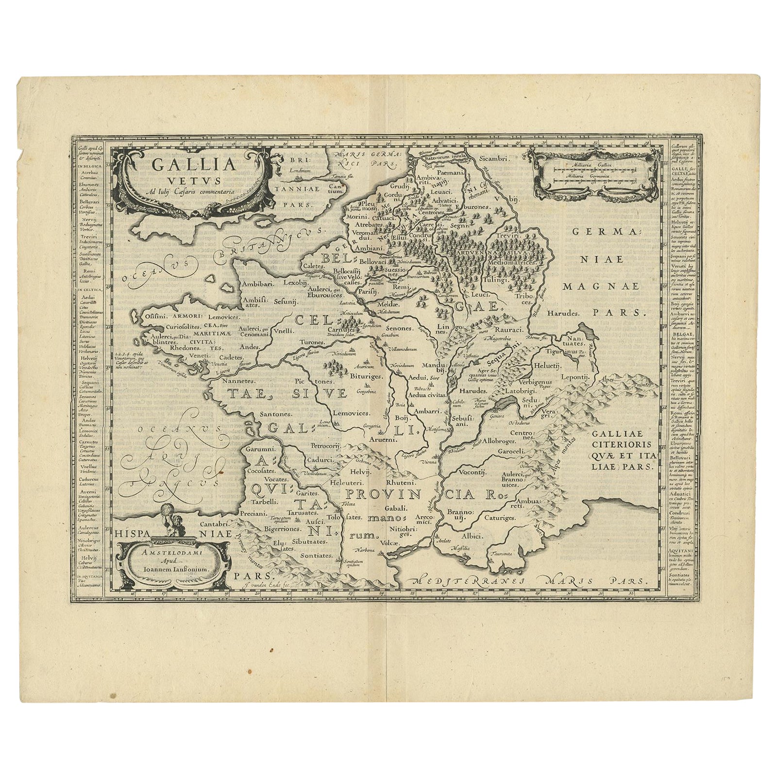
Antique Map of France by Janssonius, c.1650
Located in Langweer, NL
Antique map titled 'Gallia Vetus'. Beautiful map of France based on Caesar's De Bello Gallico. In the columns to the left and right important tribes and people are described.
Art...
Category
Antique 17th Century Maps
Materials
Paper
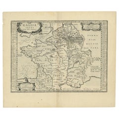
$503 Sale Price
20% Off
Intriguing Antique Map of Europe, Asia and Africa by Scherer, c.1703
Located in Langweer, NL
Two maps on a single sheet showing Europe, Asia and Africa, each depicting nearly the same area. On close examination there are slight differences. Major cities are located. Printed ...
Category
Antique 18th Century Maps
Materials
Paper
$287 Sale Price
20% Off
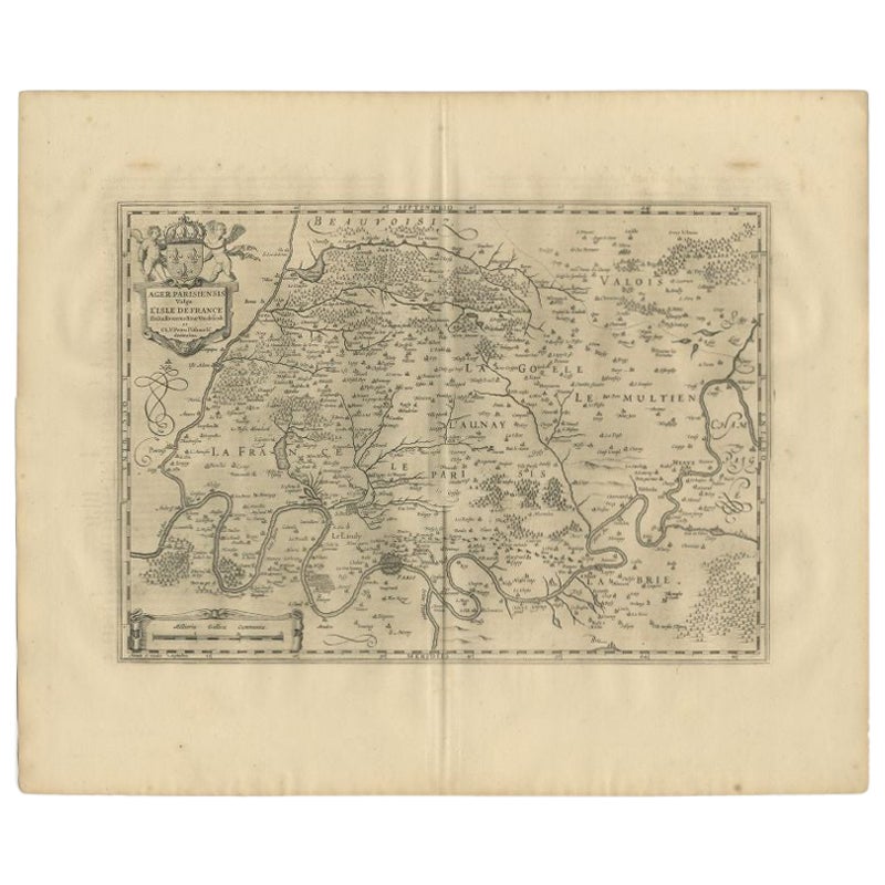
Antique Map of the Region of 'Île de France' by Janssonius, 1657
By Johannes Janssonius
Located in Langweer, NL
Antique map of France titled 'Ager Parisiensis vulgo l'Isle de France'. Old map of Paris and adjacent regions. This map originates from 'Atlas Novus, ...
Category
Antique 17th Century Maps
Materials
Paper
$407 Sale Price
20% Off
You May Also Like
Original Antique Map of Europe, Arrowsmith, 1820
Located in St Annes, Lancashire
Great map of Europe
Drawn under the direction of Arrowsmith.
Copper-plate engraving.
Published by Longman, Hurst, Rees, Orme and Brown, 1820
...
Category
Antique 1820s English Maps
Materials
Paper

1714 Henri Chatelain "Nouvelle Carte Des Etatas Du Grand.Duc De Mos Moscovie Eur
Located in Norton, MA
A 1714 Henri Chatelain map, entitled
"Nouvelle Carte Des Etatas Du Grand Duc De Moscovie En Europe,"
Ricb001
Henri Abraham Chatelain (1684-1743) was a Huguenot pastor of Parisi...
Category
Antique Early 18th Century Dutch Maps
Materials
Paper

1627 Hendrik Hondius Map Entitled "Vltoniae Orientalis Pars, " Ric.a009
Located in Norton, MA
1627 Hendrik Hondius map entitled
"Vltoniae orientalis pars,"
Ric.a009
Title:
Vltoniae orientalis : pars
Title (alt.) :
Ultoniae orientalis pars
Creator:
Mercator, Gerh...
Category
Antique 17th Century Dutch Maps
Materials
Paper

1636 Jansson Map of Ireland Entitled "Comitatus Lageniae, " Ric.a007
Located in Norton, MA
1646 Jansson map entitled
"Procinvia connactiae,"
Ric.a006
Description: The PROVINCE of CONNAVGT 490 x 380From vol 4 of Jansson's Atlas Novus 1646, published in Amsterdam with...
Category
Antique 17th Century Unknown Maps
Materials
Paper

1657 Janssonius Map of Vermandois and Cappelle, Ric. A-004
Located in Norton, MA
1657 Janssonius map of
Vermandois and Cappelle
Ric.a004
Description: Antique map of France titled 'Descriptio Veromanduorum - Gouvernement de la Cappelle'. Two detailed maps o...
Category
Antique 17th Century Unknown Maps
Materials
Paper

1633 Map "La Souverainete De Sedan Et De Raucourt, Et La Prevoste Ric0011
Located in Norton, MA
1653 map entitled
"La Souverainete de Sedan et de Raucourt, et la Prevoste de Doncheri,"
Ric0011
Description:
Lovely map centered on Sedan and Doncheri and the Meuze River fr...
Category
Antique 17th Century Dutch Maps
Materials
Paper

More Ways To Browse
Celtic Furniture
Antique Map Ortelius
Antique Navigator
Map Of Middle East
Antique Map Of Switzerland
World Map Copper
British Empire Map
Malaysian Antique Furniture
Birds Eye View Map
Map Of Arabia
Map Of Vienna
Old School Maps
Balinese Wood
Joan Blaeu
Antique Nautical Maps
Antique Portuguese Plates
Antique Maps California
New Zealand Map