Items Similar to Antique Map of the Coast of New Ireland, Earlier Part of German New Guinea, 1833


Want more images or videos?
Request additional images or videos from the seller
1 of 5
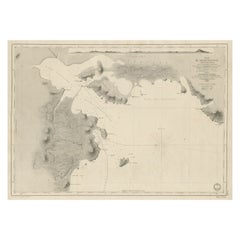
Antique Map of the Coast of New Ireland, Earlier Part of German New Guinea, 1833
$660.03
£497.13
€560
CA$910.21
A$1,022.58
CHF 534.30
MX$12,481.04
NOK 6,784.03
SEK 6,385.73
DKK 4,262.51
About the Item
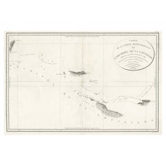
Antique map titled 'Plan du Havre Carteret sur la Cote occidentale de la Nelle Irlande.
Expedition de la Corvette de S.M. l'Astrolabe, Commandee par le CAP ne de Fregate Dumont D'Urville. Juillet 1827.' A chart of the coast of Latangai Island (then known as New Ireland), with Lamassa Island (identified as Ile Cocos), and a second island identified as Ile Leigh. Shows soundings and height profile. New Ireland, also New Mecklenburg, is the Northeastern Province of Papua New Guinea. Map no. 26 from Dumont D'Urville's "Voyage de la Corvette l'Astrolabe - Atlas"", published in Paris: J. Tastu, 1833.
New Ireland or Latangai, is a large island in Papua New Guinea, approximately 7,404 km2 (2,859 sq mi) in area with c. 120,000 people. It is named after the island of Ireland. It is the largest island of New Ireland Province, lying northeast of the island of New Britain. Both islands are part of the Bismarck Archipelago, named after Otto von Bismarck, and they are separated by Saint George's Channel. The administrative centre of the island and of New Ireland province is the town of Kavieng located at the northern end of the island. While the island was part of German New Guinea, it was named Neumecklenburg ("New Mecklenburg").
Artists and Engravers: Made by 'Chassant' after 'Mr. Paris'.
Condition: Very good, given age. A small stain in the center of the image. A few faint small stains in the far right of the image. Margins a little stained. A few small tears in the right margin (not affecting image). General age-related toning and/or occasional minor defects from handling. Please study image carefully.
Date: 1833
Overall size: 64.6 x 47.9 cm.
Image size: 59.3 x 43.1 cm.
We sell original antique maps to collectors, historians, educators and interior decorators all over the world. Our collection includes a wide range of authentic antique maps from the 16th to the 20th centuries. Buying and collecting antique maps is a tradition that goes back hundreds of years. Antique maps have proved a richly rewarding investment over the past decade, thanks to a growing appreciation of their unique historical appeal. Today the decorative qualities of antique maps are widely recognized by interior designers who appreciate their beauty and design flexibility. Depending on the individual map, presentation, and context, a rare or antique map can be modern, traditional, abstract, figurative, serious or whimsical. We offer a wide range of authentic antique maps for any budget.
- Dimensions:Height: 18.86 in (47.9 cm)Width: 25.44 in (64.6 cm)Depth: 0 in (0.01 mm)
- Materials and Techniques:
- Period:
- Date of Manufacture:1833
- Condition:Condition: Very good, given age. A small stain in the center of the image. A few faint small stains in the far right of the image. Margins a little stained. A few small tears in the right margin (not affecting image). General age-related toning.
- Seller Location:Langweer, NL
- Reference Number:Seller: PCT-568221stDibs: LU3054327795132
About the Seller
5.0
Recognized Seller
These prestigious sellers are industry leaders and represent the highest echelon for item quality and design.
Platinum Seller
Premium sellers with a 4.7+ rating and 24-hour response times
Established in 2009
1stDibs seller since 2017
2,533 sales on 1stDibs
Typical response time: <1 hour
- ShippingRetrieving quote...Shipping from: Langweer, Netherlands
- Return Policy
Authenticity Guarantee
In the unlikely event there’s an issue with an item’s authenticity, contact us within 1 year for a full refund. DetailsMoney-Back Guarantee
If your item is not as described, is damaged in transit, or does not arrive, contact us within 7 days for a full refund. Details24-Hour Cancellation
You have a 24-hour grace period in which to reconsider your purchase, with no questions asked.Vetted Professional Sellers
Our world-class sellers must adhere to strict standards for service and quality, maintaining the integrity of our listings.Price-Match Guarantee
If you find that a seller listed the same item for a lower price elsewhere, we’ll match it.Trusted Global Delivery
Our best-in-class carrier network provides specialized shipping options worldwide, including custom delivery.More From This Seller
View AllAntique Map of Indonesia by C.F. Beautemps-Beaupre, circa 1807
Located in Langweer, NL
Antique map titled 'Carte de la partie du grand archipel d'Asie'. Map of Indonesia showing tracks of Recherche and Esperance in 1792-1793. This map is...
Category
Antique Early 19th Century Maps
Materials
Paper

$707 Sale Price
20% Off
Antique Map of New Guinea and New Britain by P. Carteret, circa 1773
Located in Langweer, NL
Antique Map: A Chart of Captain Carteret's Discoveries at New Britain (1769)
This rare and historically significant 18th-century map, titled *A Chart of Captn Carteret's Discoveries at New Britain,* offers a fascinating glimpse into early European explorations of the Pacific. Published in 1769, the map meticulously charts Captain Philip Carteret's 1767 voyage through New Guinea and the islands of New Britain and New Ireland, showcasing his contributions to the understanding of the Bismarck Archipelago. Adding to its significance, the map traces the paths of earlier explorer William Dampier...
Category
Antique Late 18th Century Maps
Materials
Paper

$518 Sale Price
20% Off
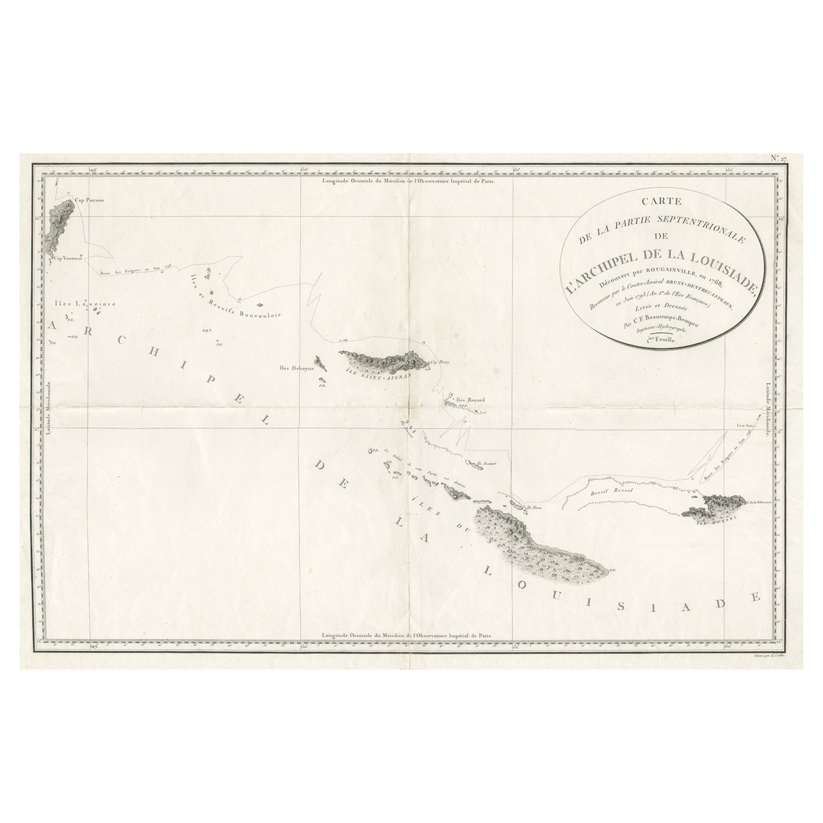
Uncommon Rare Map Showing The Louisiade Archipelago, Papua New Guinea, ca.1798
Located in Langweer, NL
Antique map titled 'Carte de la Partie Septentrionale de l'Archipel de la Louisiade'.
Uncommon map showing the area around the Louisiade Archipelago, named for Louis XV by Louis ...
Category
Antique 1790s Maps
Materials
Paper
$792 Sale Price
20% Off
Antique Map of Eastern Polynesia, 1849
Located in Langweer, NL
Antique map titled 'Ost-Polynesien'. Interesting variant issue, with large detailed insets top right of Hawaii volcanos near Kilauea. Insets lower right of Honolulu harbour, island o...
Category
Antique Mid-19th Century Maps
Materials
Paper

$165 Sale Price
30% Off
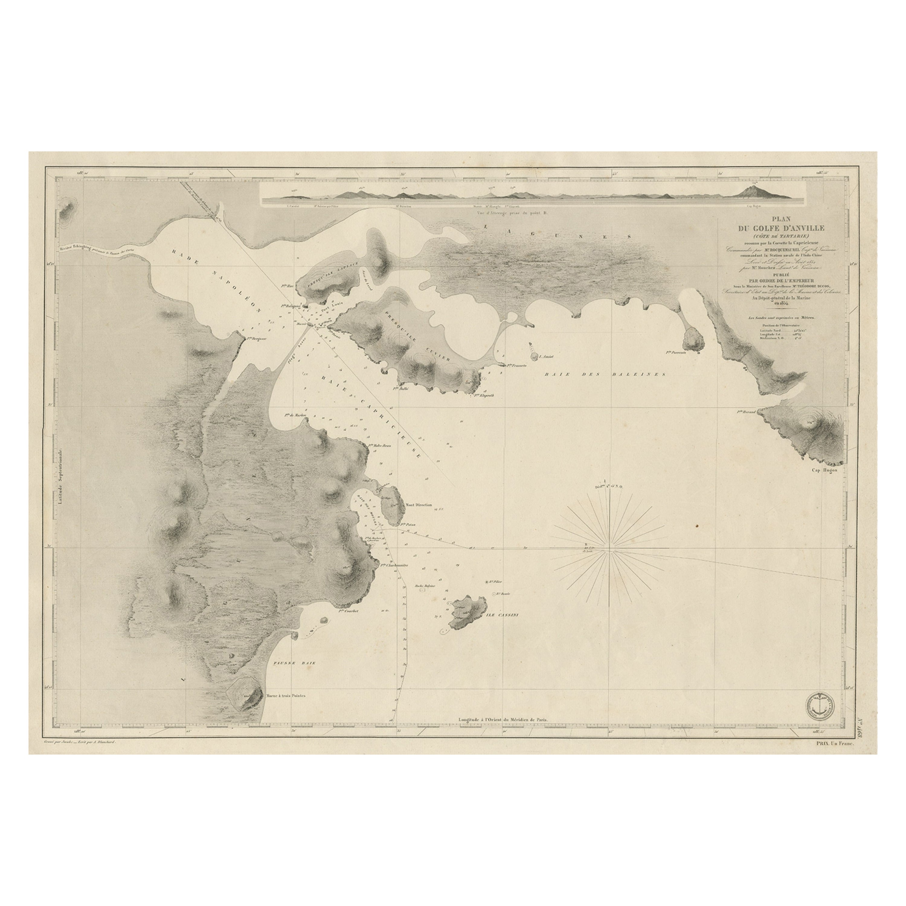
Antique Map of Part of the Chinese Coast, Explored by the French, Ca.1852
Located in Langweer, NL
Antique map titled 'Plan du Golfe D'Anville (Côte de Tartarie)'.
Old map of part of the Chinese coast, explored with the French corvette 'Caprieuse'. The Capricieuse was a late 2...
Category
Antique 1850s Maps
Materials
Paper
$651 Sale Price
34% Off
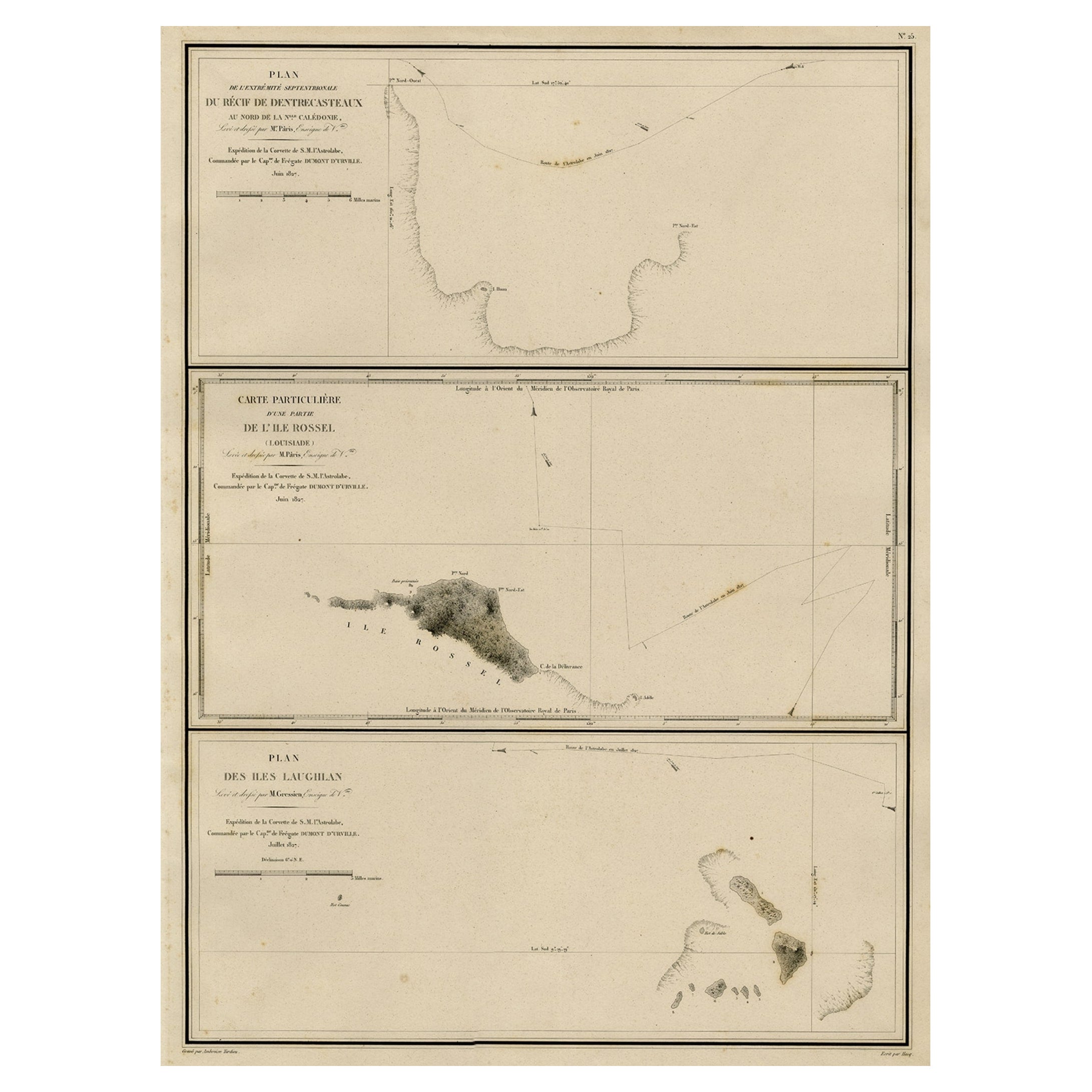
Map of the Laughlan Islands, Rossel Island & Reef North of New Caledonia, 1833
Located in Langweer, NL
Antique map titled 'Plan de l'extremite septentrionale du Recif de D'entrecasteaux. Carte Particuliere d'un partie de l'Ile Rossel (Louisiade). Plan des Iles Laughlan.'
Map of th...
Category
Antique 1830s Maps
Materials
Paper
$424 Sale Price
20% Off
You May Also Like
Large Original Antique Map of The Pacific Ocean, Fullarton, C.1870
Located in St Annes, Lancashire
Great map of The Pacific Ocean
From the celebrated Royal Illustrated Atlas
Lithograph by Swanston. Original color.
Published by Fullarton,...
Category
Antique 1870s Scottish Maps
Materials
Paper

Scarce U.S. Coast Survey Map Depicting Entrance to San Francisco Bay Dated 1856
Located in San Francisco, CA
A fine example of the 1856 U.S. Coast lithographic survey nautical chart of the entrance to San Francisco bay and the city. Published in 1856 by the Office of the Coast Survey the of...
Category
Antique Mid-19th Century American Maps
Materials
Paper

Original Antique Map of US Possessions In The Pacific Ocean, C.1900
Located in St Annes, Lancashire
Fabulous map of US possessions in the Pacific Ocean
Original color.
Engraved and printed by the George F. Cram Company, Indianapolis.
Published, C.1900.
Unframed.
Free shipping.
Category
Antique 1890s American Maps
Materials
Paper

Original Antique Map of Central America / Florida, Arrowsmith, 1820
Located in St Annes, Lancashire
Great map of Central America.
Drawn under the direction of Arrowsmith.
Copper-plate engraving.
Published by Longman, Hurst, Rees, Orme and Brown, 1820
Unframed.
Category
Antique 1820s English Maps
Materials
Paper

Large Original Antique Map of The West Indies by Sidney Hall, 1847
Located in St Annes, Lancashire
Great map of The West Indies
Drawn and engraved by Sidney Hall
Steel engraving
Original colour outline
Published by A & C Black. 1847
Unframed
Free shipping.
Category
Antique 1840s Scottish Maps
Materials
Paper

Large Original Antique Map of The Leeward Islands. 1894
Located in St Annes, Lancashire
Superb Antique map of The Leeward Islands
Published Edward Stanford, Charing Cross, London 1894
Original colour
Good condition
Unframed.
Free shipping
Category
Antique 1890s English Maps
Materials
Paper

More Ways To Browse
Antique Furniture Northern Ireland
Irish Antiques 16th Century
Antique Astrolabe
Papua New Guinea Antique Map
Otto Von Bismarck
Map Of Normandy
Bali Map
Croatia Map
Gibraltar Antique Map
Albania Antique Map
Antique Furniture Kingston
Antique Louisiana Map
Armenia Map
L Tardieu
Chinese Wall Pocket
18th Century Nautical Engraving
Antique Map Burgundy
Antique Map By Coronelli