Items Similar to Daniae Regni & Oldenburg – Antique Maps of Denmark and Saxony by Ortelius, 1598


Video Loading
Want more images or videos?
Request additional images or videos from the seller
1 of 13
Daniae Regni & Oldenburg – Antique Maps of Denmark and Saxony by Ortelius, 1598
$862.66
$1,078.3320% Off
£642.08
£802.6020% Off
€720
€90020% Off
CA$1,181.63
CA$1,477.0420% Off
A$1,314.23
A$1,642.7920% Off
CHF 686.25
CHF 857.8220% Off
MX$15,992.83
MX$19,991.0420% Off
NOK 8,764.49
NOK 10,955.6120% Off
SEK 8,219.54
SEK 10,274.4320% Off
DKK 5,481.11
DKK 6,851.3920% Off
Shipping
Retrieving quote...The 1stDibs Promise:
Authenticity Guarantee,
Money-Back Guarantee,
24-Hour Cancellation
About the Item
Daniae Regni & Oldenburg – Antique Maps of Denmark and Saxony by Ortelius, 1584
This elegant antique map sheet features two detailed regional maps side by side: Daniae Regni Typus (Kingdom of Denmark) and Oldenburg Comitatus (County of Oldenburg). Both maps were published in the 1584 edition of Abraham Ortelius’s celebrated Theatrum Orbis Terrarum, considered the first modern atlas. These early cartographic renderings provide valuable insight into 16th-century geographic knowledge and aesthetic sensibilities.
The map on the left presents Denmark, based on the pioneering cartographic work of Cornelis Anthoniszoon. The map includes a wealth of place names and cities throughout the Danish peninsula and surrounding islands. Although the map lacks extensive topographical detail, the inclusion of stippled seas and ornate compass roses enhances its visual richness. This map helped shape the European understanding of Scandinavia in the late Renaissance.
The right-hand map, Oldenburg Comitatus, focuses on a portion of Lower Saxony and was drawn from the work of Laurens Michaelis. It offers excellent detail of the river systems around Oldenburg and the surrounding areas of northwest Germany. Engraved sailing ships and sea monsters decorate the waters, reflecting Ortelius’s decorative style and the era’s fascination with maritime exploration and unknown seas.
Ortelius, a Flemish cartographer and geographer, revolutionized cartography with his Theatrum Orbis Terrarum (first published in 1570), which compiled maps from the leading cartographers of the time into one comprehensive work. This edition, with Latin text on the verso, was aimed at a learned European audience.
Condition report: Very good condition for age. Strong impression with excellent detail. Central fold as issued, with faint creasing and minor age-toning to the paper edges. No major flaws or repairs. Latin text on verso.
Framing tips: A double map of this type is best presented in a large, dark wood frame with generous ivory or sand-toned matting. Consider UV-protective glass to preserve the fine linework and prevent paper browning.
- Dimensions:Height: 18.12 in (46 cm)Width: 21.74 in (55.2 cm)Depth: 0.02 in (0.5 mm)
- Materials and Techniques:Paper,Engraved
- Place of Origin:
- Period:
- Date of Manufacture:circa 1598
- Condition:Very good condition for age. Strong impression with excellent detail. Central fold as issued, with faint creasing and minor age-toning to the paper edges. No major flaws or repairs. Latin text on verso.
- Seller Location:Langweer, NL
- Reference Number:Seller: BG-067781stDibs: LU305439800091
About the Seller
5.0
Recognized Seller
These prestigious sellers are industry leaders and represent the highest echelon for item quality and design.
Platinum Seller
Premium sellers with a 4.7+ rating and 24-hour response times
Established in 2009
1stDibs seller since 2017
2,508 sales on 1stDibs
Typical response time: <1 hour
- ShippingRetrieving quote...Shipping from: Langweer, Netherlands
- Return Policy
Authenticity Guarantee
In the unlikely event there’s an issue with an item’s authenticity, contact us within 1 year for a full refund. DetailsMoney-Back Guarantee
If your item is not as described, is damaged in transit, or does not arrive, contact us within 7 days for a full refund. Details24-Hour Cancellation
You have a 24-hour grace period in which to reconsider your purchase, with no questions asked.Vetted Professional Sellers
Our world-class sellers must adhere to strict standards for service and quality, maintaining the integrity of our listings.Price-Match Guarantee
If you find that a seller listed the same item for a lower price elsewhere, we’ll match it.Trusted Global Delivery
Our best-in-class carrier network provides specialized shipping options worldwide, including custom delivery.More From This Seller
View AllAntique Map of East Frisia by Ortelius, c.1595
Located in Langweer, NL
Antique print, titled: 'Frisia Orientalis.' Map of East Frisia originating from 'Theatrum Orbis Terrarum'. It is based on the manuscript map by Jon Bloe...
Category
Antique 16th Century Maps
Materials
Paper

$814 Sale Price
20% Off
Antique Map of Denmark and Southern Sweden, c.1658
Located in Langweer, NL
Antique map titled 'Royaume de Danemarq.' Map centered on Sjaelland and covers all of Denmark and part of southern Sweden where a dramatic title cartouche obscures the interior. Sour...
Category
Antique 17th Century Maps
Materials
Paper

$258 Sale Price
20% Off
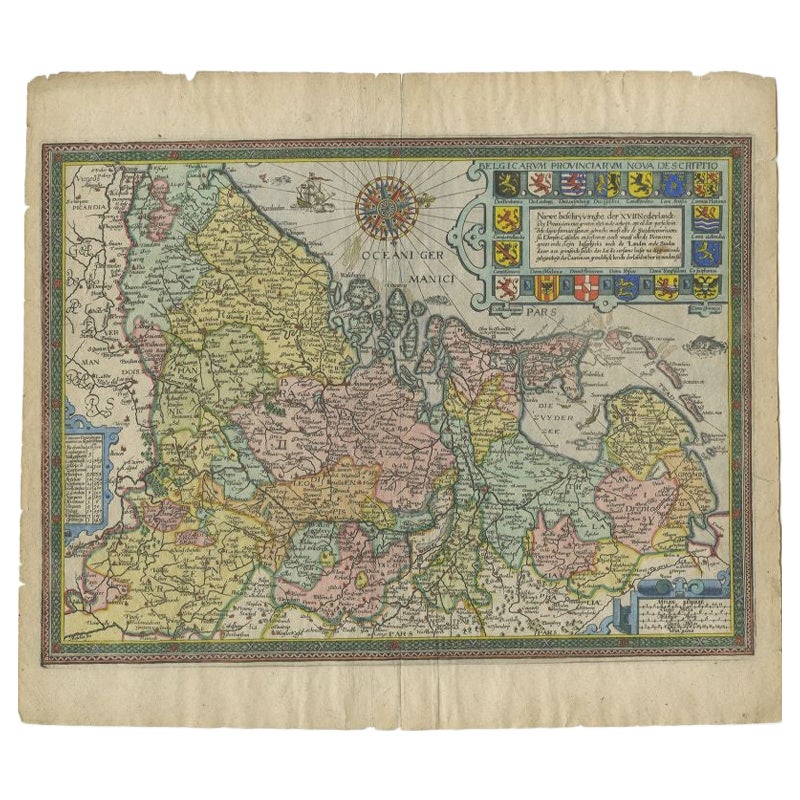
Antique Map of the Netherlands by Guicciardini, 1612
Located in Langweer, NL
Antique map titled 'Belgicarum Provinciarum Nova Descriptio'. Beautiful old map of the Netherlands. With decorative cartouche including the coat...
Category
Antique 17th Century Maps
Materials
Paper
$430 Sale Price
20% Off
Antique Map of Denmark with Schleswig-Holstein and the South of Sweden, c.1750
Located in Langweer, NL
Antique map titled 'General Charte von Konigreich Daenemark nebst dem Herzogthum Holstein.' Denmark with Schleswig-Holstein and the southern coast of Sweden. The large title cartouch...
Category
Antique 18th Century Maps
Materials
Paper

$354 Sale Price
20% Off
Antique Map of Denmark by F. de Wit, 1680
Located in Langweer, NL
Antique map titled 'Dania Regnum'. Large, attractive map of Denmark, Sleschwig-Holstein and southern Sweden. Good detail throughout. Embellished with a title cartouche with the Danis...
Category
Antique Late 17th Century Maps
Materials
Paper

$924 Sale Price
20% Off
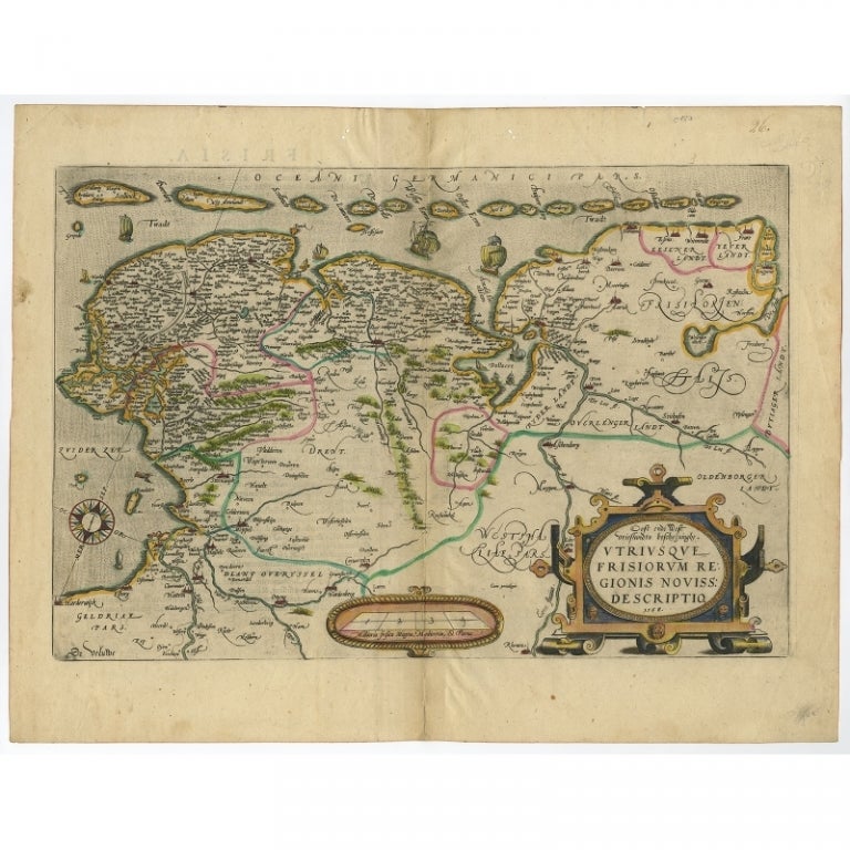
Antique Map of Friesland with Elaborate Cartouche by Mapmaker Ortelius, c.1570
Located in Langweer, NL
Antique map titled 'Oost end West Vrieslandts beschrijvinghe. Utriusque Frisiorum Regionis Noviss: Descriptio. 1568.' Detailed map of Friesland, the Netherlands. Includes a larger co...
Category
Antique 16th Century Maps
Materials
Paper

$910 Sale Price
20% Off
You May Also Like
Original Antique Map of Sweden, Engraved by Barlow, 1806
Located in St Annes, Lancashire
Great map of Sweden
Copper-plate engraving by Barlow
Published by Brightly & Kinnersly, Bungay, Suffolk. 1806
Unframed.
Category
Antique Early 1800s English Maps
Materials
Paper

1646 Jansson Map Entitled "Procinvia Connactiae, " Ric.a006
Located in Norton, MA
1646 Jansson map entitled
"Procinvia connactiae,"
Ric.a006
Description: The PROVINCE of CONNAVGT 490 x 380From vol 4 of Jansson's Atlas Novus 1646, published in Amsterdam with...
Category
Antique 17th Century Unknown Maps
Materials
Paper

1636 Jansson Map of Ireland Entitled "Comitatus Lageniae, " Ric.a007
Located in Norton, MA
1646 Jansson map entitled
"Procinvia connactiae,"
Ric.a006
Description: The PROVINCE of CONNAVGT 490 x 380From vol 4 of Jansson's Atlas Novus 1646, published in Amsterdam with...
Category
Antique 17th Century Unknown Maps
Materials
Paper

17th Century Map of Denmark by French Cartographer Sanson, Dated 1658
By Nicolas Sanson
Located in Copenhagen, K
17th century map of Denmark by French cartographer Sanson.
Nicolas Sanson (20 December 1600-7 July 1667) was a French cartographer, termed by some the creator of French geography an...
Category
Antique 17th Century French Maps
Materials
Paper

1590 Ortelius Map of Calais and Vermandois, France and Vicinity Ric.a014
Located in Norton, MA
1590 Ortelius map of
Calais and Vermandois, France and Vicinity
Ric.a014
Two rare regional Abraham Ortelius maps on a single folio sheet. Left map, entitled Caletensium, depic...
Category
Antique 16th Century Dutch Maps
Materials
Paper

1592 Abraham Ortelius Map "Lorraine: Lotharingiae Nova Descripti, Ric.A005
Located in Norton, MA
1592 Abraham Ortelius map entitled
"Lorraine: Lotharingiae Nova Descripti
Ric.a005
Description: Ortelius is best known for producing the atlas from which this map comes from, "...
Category
Antique 16th Century Dutch Maps
Materials
Paper

More Ways To Browse
Sea Monster
Carved Cabriole Table
Dark Antique Table
Antique Wall Table
1960 Chair Wood Danish
Unusual Dining Table
Antique Dutch Plates
Mdf Table
Showcase Coffee Table
Space Age Orange
Vallauris France
Silver Ladle
Scalloped Table
Brazil Wood Chairs
Vintage Art Deco Side Tables
Window Display
1960s Cushion Chair
Green Brown Oriental Rug