Items Similar to Antique Map of France with an Inset Map of the Island of Corsica, c.1820

Want more images or videos?
Request additional images or videos from the seller
1 of 10
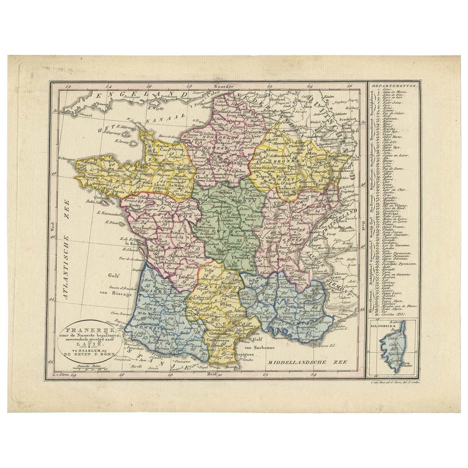
Antique Map of France with an Inset Map of the Island of Corsica, c.1820
$172.53
$215.6720% Off
£128.44
£160.5520% Off
€144
€18020% Off
CA$236.33
CA$295.4120% Off
A$262.85
A$328.5620% Off
CHF 137.25
CHF 171.5620% Off
MX$3,198.57
MX$3,998.2120% Off
NOK 1,752.90
NOK 2,191.1220% Off
SEK 1,643.91
SEK 2,054.8920% Off
DKK 1,096.22
DKK 1,370.2820% Off
Shipping
Retrieving quote...The 1stDibs Promise:
Authenticity Guarantee,
Money-Back Guarantee,
24-Hour Cancellation
About the Item
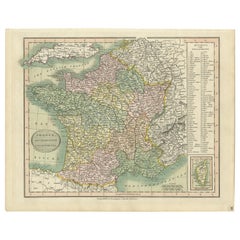
Antique map titled 'Frankrijk naar de nieuwste bepalingen meerendeels gevolgd naar Lapie'. Beautiful map of France with an inset map of the island of Corsica. Includes a table with reference to the departments. Artists and Engravers: Engraved by C. van Baarsel & Zoon. Published by F. Bohn, Haarlem.
Artist: Engraved by C. van Baarsel & Zoon. Published by F. Bohn, Haarlem.
Condition: Good, original/contemporary hand coloring. General age-related toning, blank verso. Few stains. Please study image carefully.
Date: c.1820
Overall size: 31 x 24 cm.
Image size: 25 x 20.5 cm.
We sell original antique maps to collectors, historians, educators and interior decorators all over the world. Our collection includes a wide range of authentic antique maps from the 16th to the 20th centuries. Buying and collecting antique maps is a tradition that goes back hundreds of years. Antique maps have proved a richly rewarding investment over the past decade, thanks to a growing appreciation of their unique historical appeal. Today the decorative qualities of antique maps are widely recognized by interior designers who appreciate their beauty and design flexibility. Depending on the individual map, presentation, and context, a rare or antique map can be modern, traditional, abstract, figurative, serious or whimsical. We offer a wide range of authentic antique maps for any budget.
- Dimensions:Height: 9.45 in (24 cm)Width: 12.21 in (31 cm)Depth: 0 in (0.01 mm)
- Materials and Techniques:
- Place of Origin:
- Period:
- Date of Manufacture:circa 1820
- Condition:Condition: Good, original/contemporary hand coloring. General age-related toning, blank verso. Few stains. Please study image carefully.
- Seller Location:Langweer, NL
- Reference Number:Seller: BG-12390-401stDibs: LU3054326273202
About the Seller
5.0
Recognized Seller
These prestigious sellers are industry leaders and represent the highest echelon for item quality and design.
Platinum Seller
Premium sellers with a 4.7+ rating and 24-hour response times
Established in 2009
1stDibs seller since 2017
2,508 sales on 1stDibs
Typical response time: <1 hour
- ShippingRetrieving quote...Shipping from: Langweer, Netherlands
- Return Policy
Authenticity Guarantee
In the unlikely event there’s an issue with an item’s authenticity, contact us within 1 year for a full refund. DetailsMoney-Back Guarantee
If your item is not as described, is damaged in transit, or does not arrive, contact us within 7 days for a full refund. Details24-Hour Cancellation
You have a 24-hour grace period in which to reconsider your purchase, with no questions asked.Vetted Professional Sellers
Our world-class sellers must adhere to strict standards for service and quality, maintaining the integrity of our listings.Price-Match Guarantee
If you find that a seller listed the same item for a lower price elsewhere, we’ll match it.Trusted Global Delivery
Our best-in-class carrier network provides specialized shipping options worldwide, including custom delivery.More From This Seller
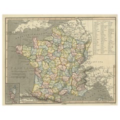
View AllAntique Map of France with Inset Map of the Island of Corsica, 1820
Located in Langweer, NL
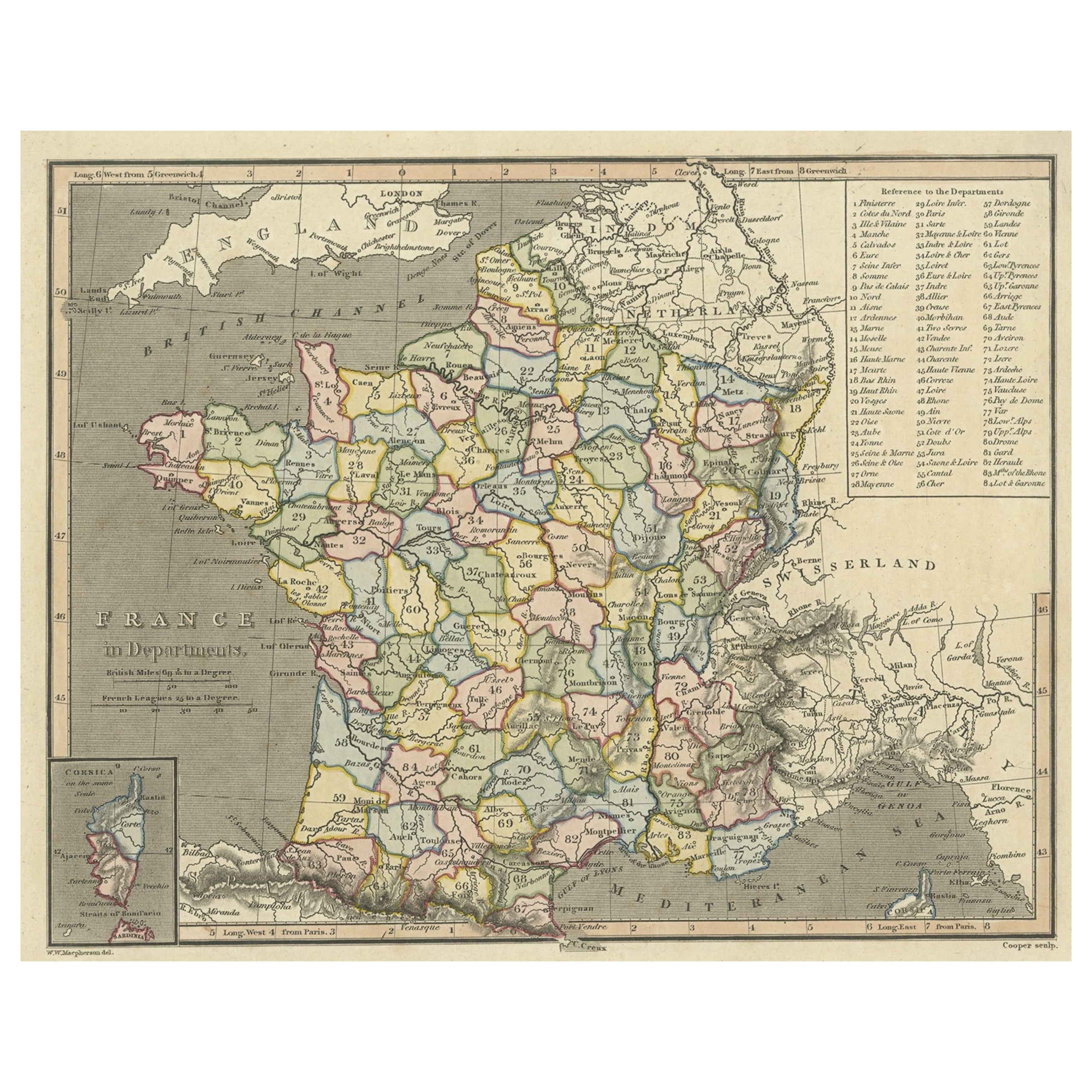
Antique map titled 'France in Departments'. Old map of France, with small inset map of the island of Corsica. Includes a table with reference to the departments.
Artists and Engr...
Category
Antique 19th Century Maps
Materials
Paper
$249 Sale Price
20% Off
Antique Map of France by Van Baarsel (c.1820)
Located in Langweer, NL
'Frankrijk naar de nieuwste bepalingen meerendeels gevolgd naar Lapie'. Beautiful map of France with an inset map of the island of Corsica. Includes a table with reference to the dep...
Category
Antique Early 19th Century Dutch Maps
Materials
Paper

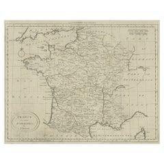
Antique Map of France Showing Post-Napoleonic Departments, 1816
Located in Langweer, NL
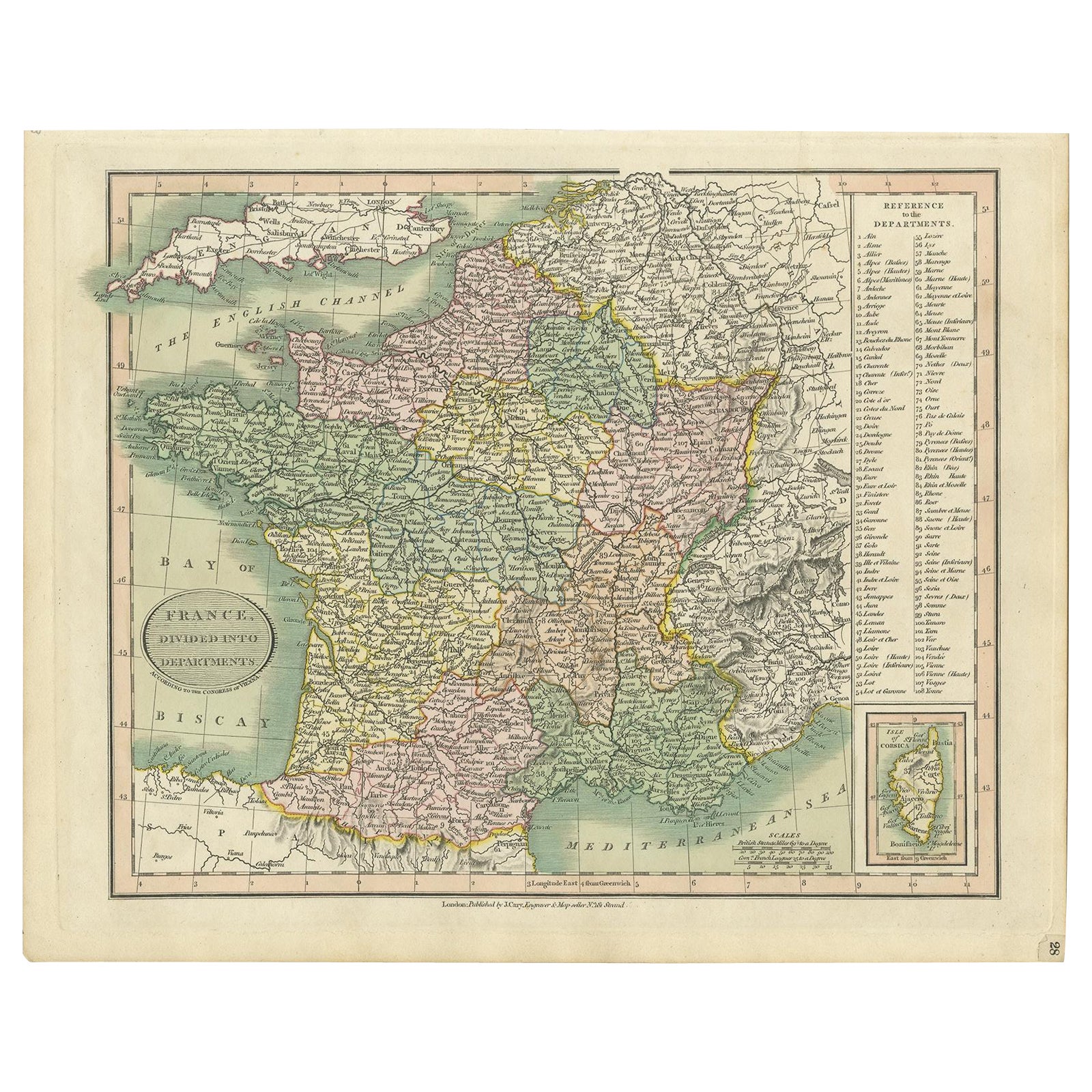
Antique map of France titled 'France divided into departments'. Detailed map of France, colored by post-Napoleonic Departments. With an inset map of Corsica...
Category
Antique 19th Century Maps
Materials
Paper
$268 Sale Price
20% Off
Antique Map of France by Bowen, c.1790
Located in Langweer, NL
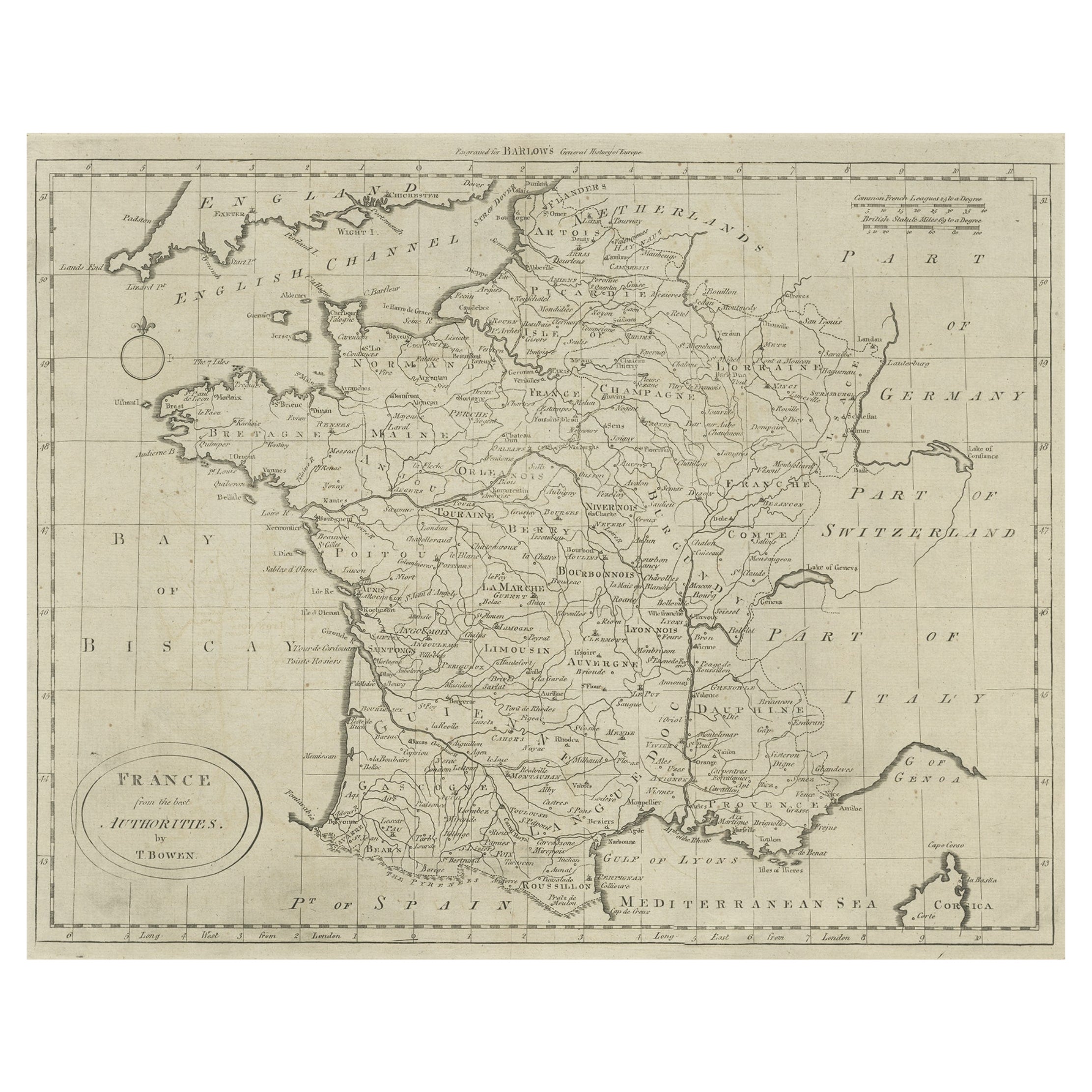
Antique map titled 'France from the best Authorities'. Original antique map of France. Engraved for Barlow's General history of Europe. Published circa 1790.
Artists and Engraver...
Category
Antique 18th Century Maps
Materials
Paper
$325 Sale Price
20% Off
Antique Map of France by Lapie, 1842
Located in Langweer, NL
Antique map titled 'Carte des Gaules'. Map of France. This map originates from 'Atlas universel de géographie ancienne et moderne (..)' by Pierre M. Lapie and Alexandre E. Lapie. Pie...
Category
Antique Mid-19th Century Maps
Materials
Paper

$479 Sale Price
20% Off
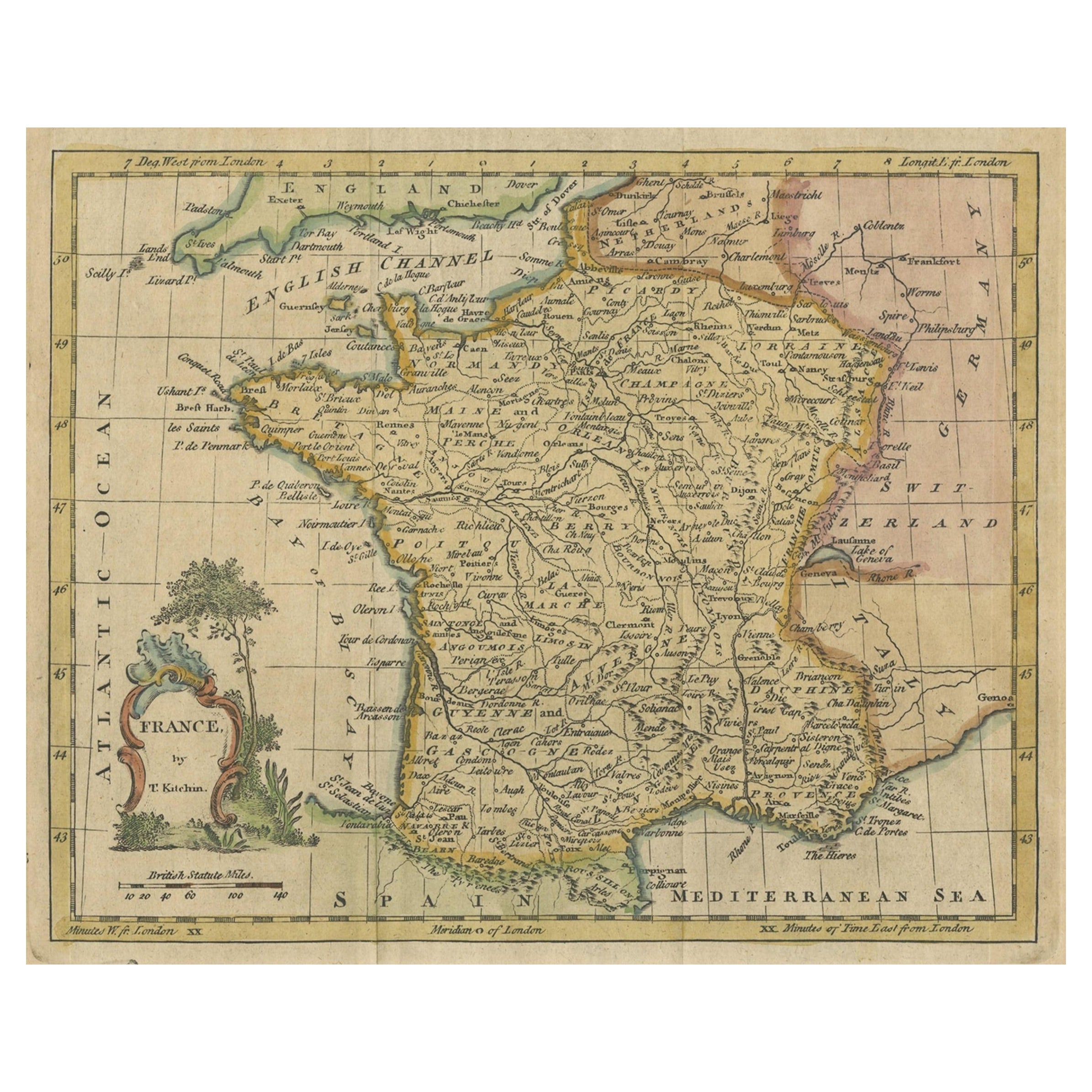
Antique Map of France by Kitchin, c.1770
Located in Langweer, NL
Antique map titled 'France'. Original antique map of France. Source unknown, to be determined.
Artists and Engravers: Thomas Kitchin (or Thomas Kitchen (1718 - 1784) was an Englis...
Category
Antique 18th Century Maps
Materials
Paper

You May Also Like
Map of France - Etching - 1820
Located in Roma, IT
Map of France is an Original Etching realized by an unknown artist of 19th century in 1820.
Very good condition on two sheets of white paper joined at t...
Category
1820s Modern Figurative Prints
Materials
Etching

Large 19th Century Map of France
Located in Pease pottage, West Sussex
Large 19th Century Map of France.
Remarkable condition, with a pleasing age worn patina.
Recently framed.
France Circa 1874.
Category
Antique Late 19th Century French Maps
Materials
Linen, Paper

The Normandy Region of France: A 17th C. Hand-colored Map by Sanson and Jaillot
By Nicolas Sanson
Located in Alamo, CA
This large hand-colored map entitled "Le Duché et Gouvernement de Normandie divisée en Haute et Basse Normandie en divers Pays; et par evêchez, avec le Gouvernement General du Havre ...
Category
Antique 1690s French Maps
Materials
Paper

Antique Map of France
Located in Dallas, TX
Nice antique map of France in wood frame. This would make a great gift for a collector. A wonderful accessory!
Category
Early 20th Century Decorative Art
Materials
Glass, Wood, Paper

$1,760
Original Antique Map of Europe, Arrowsmith, 1820
Located in St Annes, Lancashire
Great map of Europe
Drawn under the direction of Arrowsmith.
Copper-plate engraving.
Published by Longman, Hurst, Rees, Orme and Brown, 1820
...
Category
Antique 1820s English Maps
Materials
Paper

1771 Bonne Map of Poitou, Touraine and Anjou, France, Ric.a015
Located in Norton, MA
1771 Bonne Map of Poitou,
Touraine and Anjou, France
Ric.a015
1771 Bonne map of Potiou, Touraine and Anjou entitled "Carte des Gouvernements D'Anjou et du Saumurois, de la Touraine, du Poitou,du Pays d'aunis, Saintonge?Angoumois,"
Carte des gouvernements d'Anjou et du Saumurois, de la Touraine, du Poitou, du Pays d'Aunis, Saintonge-Angoumois. Projettee et assujettie au ciel par M. Bonne, Hyd. du Roi. A Paris, Chez Lattre, rue St. Jacques a la Ville de Bord(ea)ux. Avec priv. du Roi. 1771. Arrivet inv. & sculp., Atlas moderne ou collection de cartes sur toutes...
Category
Antique 17th Century Unknown Maps
Materials
Paper

More Ways To Browse
C F Modern
French 16th Table
World Map Table
1820 World Map
Map Of Singapore
Migeon Migeon
Scottish Coat Of Arms
Antique Maps Of Canada
Antique Railroad Maps
Relief Map
Antique Map Of Venice
Antique Map Of Georgia
Antique Nautical Charts
Hand Painted Antique Map
Antique Maps New Zealand
Antique Maps Persia
Map Railroad
Mariner Furniture