Items Similar to Antique Map of the Harbour of Taloo by J. Cook, 1803


Want more images or videos?
Request additional images or videos from the seller
1 of 5
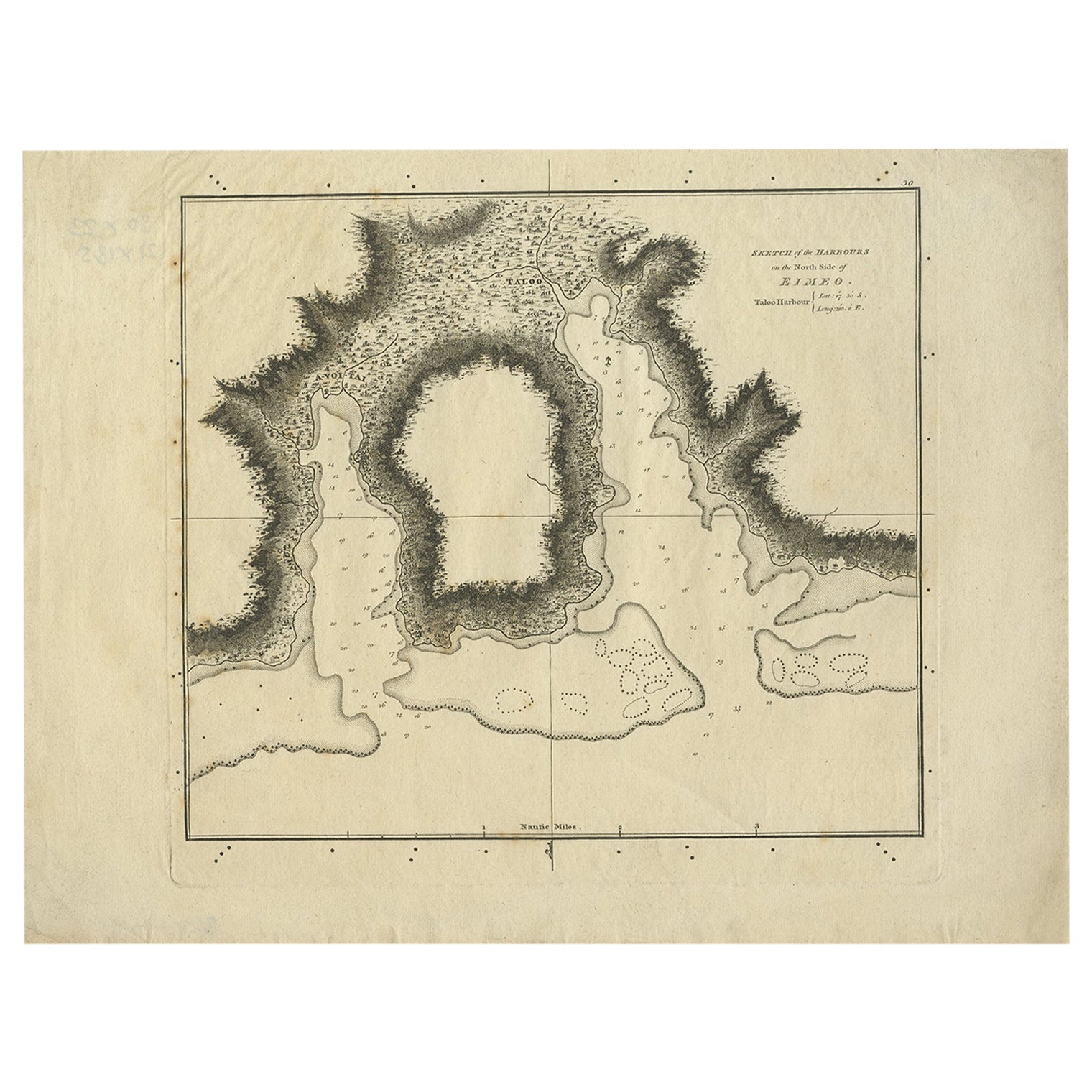
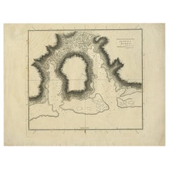
Antique Map of the Harbour of Taloo by J. Cook, 1803
$335.37
£248.53
€280
CA$457.84
A$509.33
CHF 267
MX$6,223.87
NOK 3,399.86
SEK 3,200.50
DKK 2,131.90
Shipping
Retrieving quote...The 1stDibs Promise:
Authenticity Guarantee,
Money-Back Guarantee,
24-Hour Cancellation
About the Item
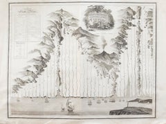
Antique map French Polynesia titled 'Schets van de Havenen aan de Noord Zijde van Eimeo'. Plan of the harbour of Taloo in the Island of Moorea, one of the Society Islands, French Polynesia. Originates from 'Reize rondom de Waereld door James Cook (..)'.
- Creator:James Cook (Artist)
- Dimensions:Height: 9.26 in (23.5 cm)Width: 12.01 in (30.5 cm)Depth: 0.02 in (0.5 mm)
- Materials and Techniques:
- Place of Origin:
- Period:
- Date of Manufacture:1803
- Condition:General age-related toning, please study image carefully.
- Seller Location:Langweer, NL
- Reference Number:Seller: BG-11487-401stDibs: LU3054313291132
About the Seller
5.0
Recognized Seller
These prestigious sellers are industry leaders and represent the highest echelon for item quality and design.
Platinum Seller
Premium sellers with a 4.7+ rating and 24-hour response times
Established in 2009
1stDibs seller since 2017
2,494 sales on 1stDibs
Typical response time: 1 hour
- ShippingRetrieving quote...Shipping from: Langweer, Netherlands
- Return Policy
Authenticity Guarantee
In the unlikely event there’s an issue with an item’s authenticity, contact us within 1 year for a full refund. DetailsMoney-Back Guarantee
If your item is not as described, is damaged in transit, or does not arrive, contact us within 7 days for a full refund. Details24-Hour Cancellation
You have a 24-hour grace period in which to reconsider your purchase, with no questions asked.Vetted Professional Sellers
Our world-class sellers must adhere to strict standards for service and quality, maintaining the integrity of our listings.Price-Match Guarantee
If you find that a seller listed the same item for a lower price elsewhere, we’ll match it.Trusted Global Delivery
Our best-in-class carrier network provides specialized shipping options worldwide, including custom delivery.More From This Seller
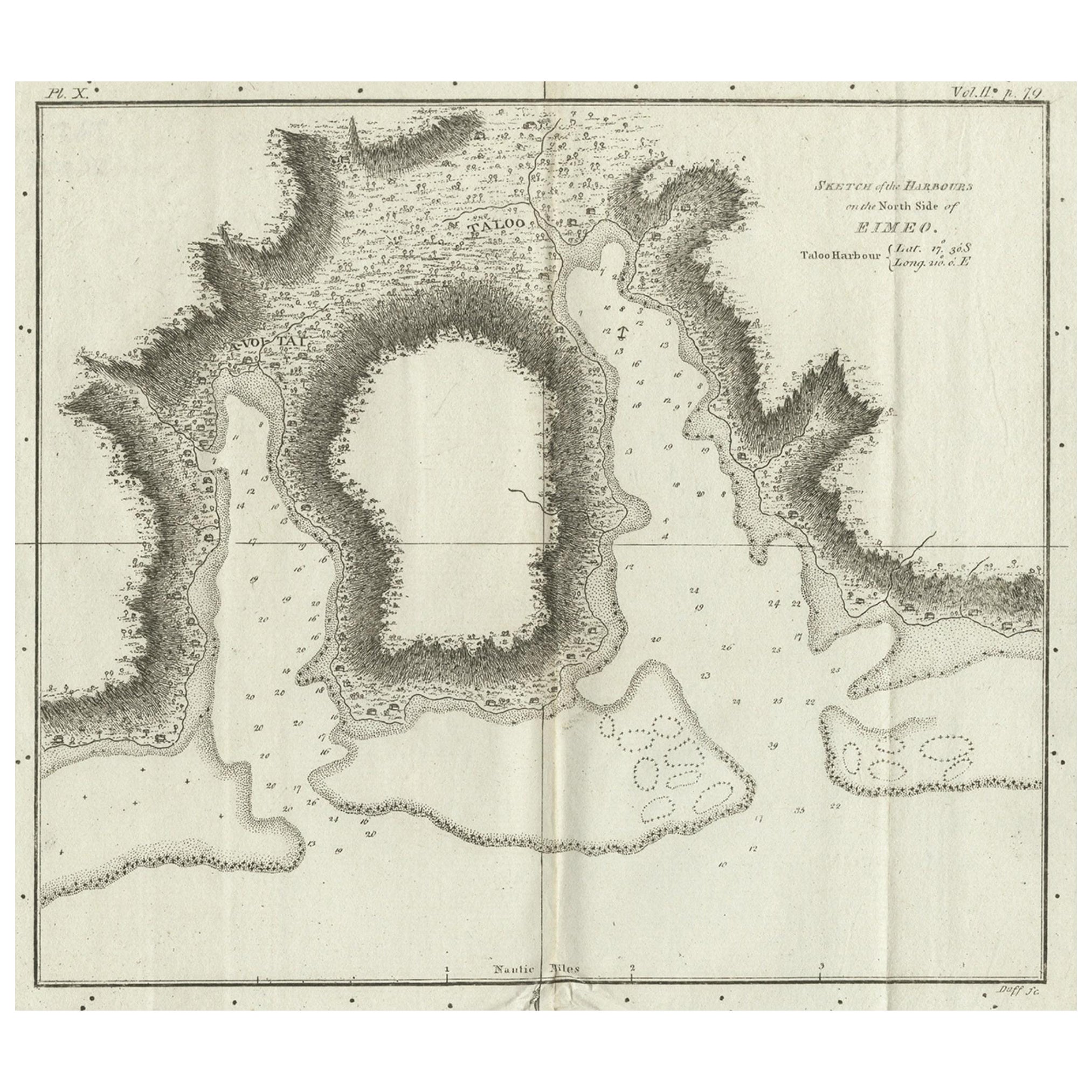
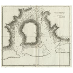
View AllAntique Plan of the Harbour of Taloo by Cook, 1784
Located in Langweer, NL
Antique map titled 'Sketch of the Harbours on the North Side of Eimeo (..)'. Plan of the harbour of Taloo in the Island of Moorea, one of the Society Islands, French Polynesia. Origi...
Category
Antique 18th Century Maps
Materials
Paper
$182 Sale Price
20% Off
Antique Plan of the Harbour of Taloo by Cook, c.1781
Located in Langweer, NL
Antique map titled 'Sketch of the Harbours on the North Side of Eimeo (..)'. Plan of the harbour of Taloo in the Island of Moorea, one of the Society Islands, French Polynesia. Origi...
Category
Antique 18th Century Maps
Materials
Paper
$220 Sale Price
20% Off
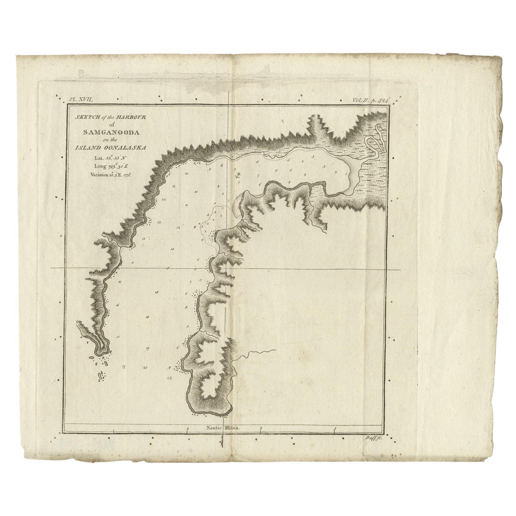
Antique Map of the Harbour of Samganoodha by Cook, c.1781
Located in Langweer, NL
Antique map titled 'Sketch of the Harbour of Samganooda (..)'. Antique map of the Harbour of Samganoodha, Oonalaska, North America. Originates from an edition of Cook's Voyages.
Art...
Category
Antique 18th Century Maps
Materials
Paper
$133 Sale Price
20% Off
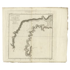
Original Antique Map of the Harbour of Tongatabu by Cook, 1784
Located in Langweer, NL
Antique map titled 'Sketch of Tongataboo Harbour (..)'. Antique map of the harbour of Tongatabu, one of the Tonga Islands. Originates from an edition of Cook's Voyages.
Artists an...
Category
Antique 18th Century Maps
Materials
Paper

$421 Sale Price
20% Off
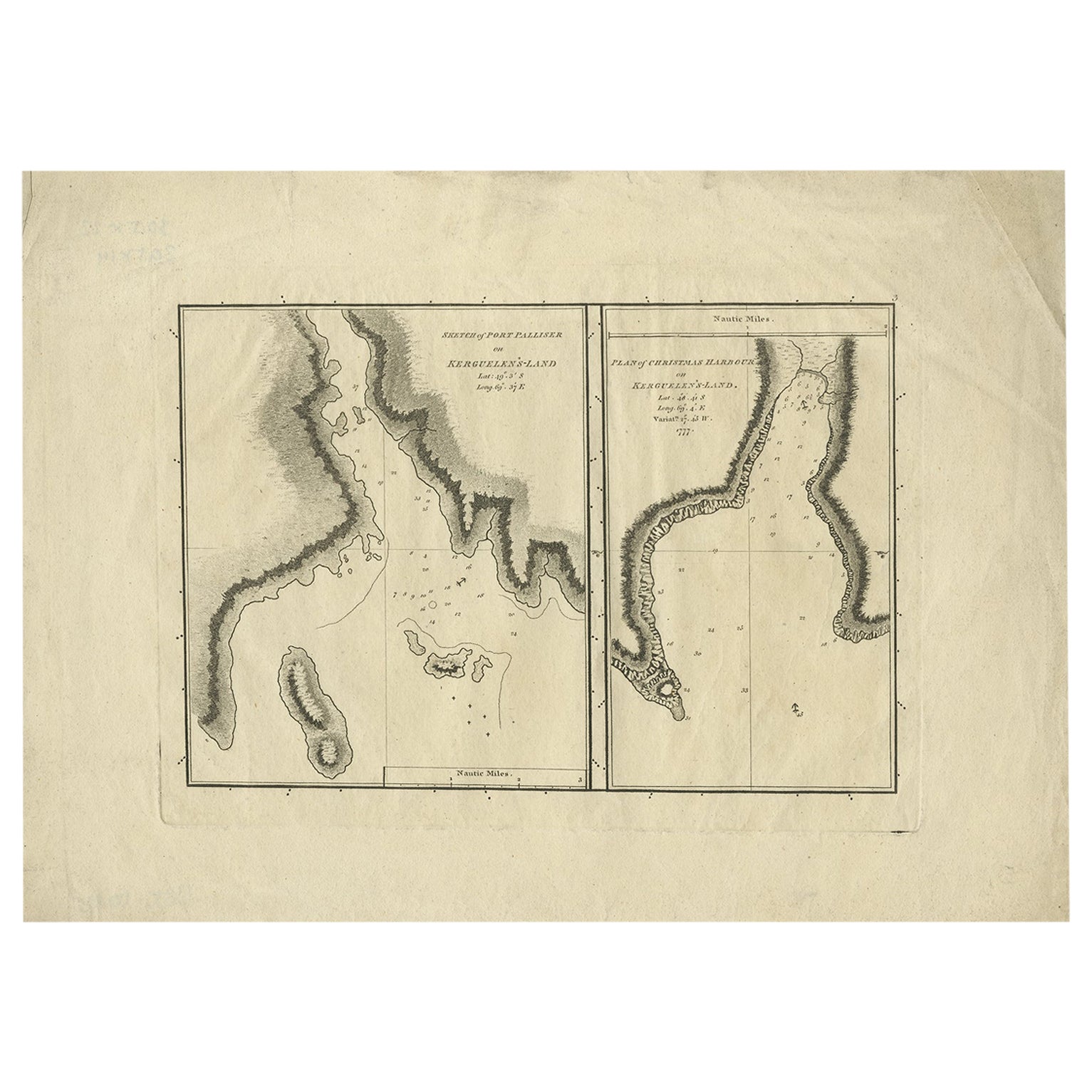
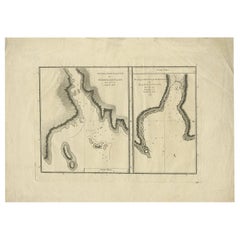
Antique Map of Port Pallisers & Kersmis by Cook, 1784
Located in Langweer, NL
Antique map Kerguelen titled 'Sketch of Port Palliser on Kerguelen's Land (..)'. Antique map of Port Pallisers & Kersmis, Kerguelen or Desolation Islands. Originates from an edition ...
Category
Antique 18th Century Maps
Materials
Paper
$210 Sale Price
20% Off
Antique Map of Port Pallisers & Kersmis by Cook, c.1781
Located in Langweer, NL
Antique map Kerguelen titled 'Sketch of Port Palliser on Kerguelen's Land (..)'. Antique map of Port Pallisers & Kersmis, Kerguelen or Desolation Islands. Originates from an edition ...
Category
Antique 18th Century Maps
Materials
Paper

$220 Sale Price
20% Off
You May Also Like
Plan of Port Siagi - Etching by Joseph Roux - 1795
Located in Roma, IT
Plan of Port Siagi is al colored etching realized by Joseph Roux in 1795.
The title at the top " Plan du Port Siagi"
Passepartout included: 34 x 49
The artwork is hand water-color...
Category
1790s Modern Figurative Prints
Materials
Etching

Dartmouth, England: A Hand-Colored 17th Century Sea Chart by Captain Collins
By Captain Greenvile Collins
Located in Alamo, CA
This hand-colored sea chart of the area around Dartmouth, England is from "Great Britain's Coasting Pilot. Being a New and Exact Survey of the Sea-Coast of England", first published ...
Category
Antique Late 17th Century English Maps
Materials
Paper

West Coast of Africa, Guinea & Sierra Leone: An 18th Century Map by Bellin
By Jacques-Nicolas Bellin
Located in Alamo, CA
Jacques Bellin's copper-plate map entitled "Partie de la Coste de Guinee Dupuis la Riviere de Sierra Leona Jusquau Cap das Palmas", depicting the coast of Guinea and Sierra Leone in ...
Category
Antique Mid-18th Century French Maps
Materials
Paper

1814 Map of "Russian Empire" Ric.r032
Located in Norton, MA
1814 Map of
"Russian Empire"
Ric.r032
Russian Empire. Description: This is an 1814 John Thomson map of the Russian Empire. The map depicts the region from the Baltic Sea, Prussia, and Sweden to the Aleutian Islands and from the Arctic Ocean to the Yellow River. Highly detailed, myriad cities, towns, and villages are labeled throughout, including St. Petersburg, Moscow, Minsk, Kiev, and Kharkov. Rivers and mountain ranges are also identified, as are islands and numerous locations along the coastlines. It is important to note that the long-disputed sea between Korea and Japan is identified as the 'Sea of Japan.
Historical Context:
In 1815, Tsarist Russia emerged from the Napoleonic Wars economically insolvent and politically fearful of the Revolutionary fervor that had just swept through Europe. In order to shore up Russia's economic position, the Tsars began an aggressive series of expansions into the Caucuses and Central Asia that would vastly increase the landmass of the Russian Empire.
Publication History
Thomson maps are known for their stunning color, awe inspiring size, and magnificent detail. Thomson's work, including this map, represents some of the finest cartographic art...
Category
Antique 19th Century Unknown Maps
Materials
Paper

St. Christophe 'St. Kitts' Island: An 18th Century Hand-colored Map by Bellin
By Jacques-Nicolas Bellin
Located in Alamo, CA
Jacques Bellin's copper-plate map of the Caribbean island of Saint Kitts entitled "Carte De De l'Isle St. Christophe Pour servir á l'Histoire Genle. des V...
Category
Antique Mid-18th Century French Maps
Materials
Paper

John Thomson (1777-1840) - 1830 Map Engraving, The Rivers of the World
By John Thomson
Located in Corsham, GB
A fine engraved chart table showing the lengths of the principal rivers across the world, from the second edition of John Thomson's 'New General Atlas' published in 1830. On paper.
Category
Early 19th Century More Prints
Materials
Engraving
$349 Sale Price
20% Off
More Ways To Browse
Antique Cook
Cook Islands
James Cook Map
London Antique Maps
Antique Map Of England
Gold Maps
China Map
17th Century World Map
Antique Maps Of Britain
Antique Furniture Edinburgh
Antique English Maps
Map Of India
British Empire Furniture
American West Antiques
Furniture Russian 18th Century
Antique Law Office Furniture
Map Stand
Antique Maps Of Italy