Items Similar to Antique Map of the Low Countries and Surroundings in Europe, 1685


Want more images or videos?
Request additional images or videos from the seller
1 of 7
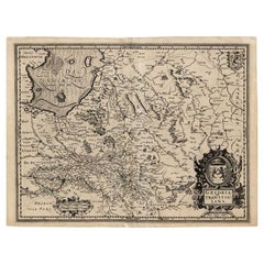
Antique Map of the Low Countries and Surroundings in Europe, 1685
$143.78
$179.7220% Off
£107.03
£133.7920% Off
€120
€15020% Off
CA$196.94
CA$246.1720% Off
A$219.04
A$273.8020% Off
CHF 114.38
CHF 142.9720% Off
MX$2,665.47
MX$3,331.8420% Off
NOK 1,460.75
NOK 1,825.9320% Off
SEK 1,369.92
SEK 1,712.4020% Off
DKK 913.52
DKK 1,141.9020% Off
Shipping
Retrieving quote...The 1stDibs Promise:
Authenticity Guarantee,
Money-Back Guarantee,
24-Hour Cancellation
About the Item
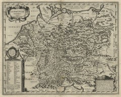
Antique map titled 'Germaniae Cisrhenanae ut ineter I Caesaris et Traiani Suit imperia Scaldis Item Mose ac Rheni.' Miniature map of the Low Countries and part of Germany and France. From the pocket atlas 'Introductionis in Universam Geographiam tam Veterem quam novam .. Acessit P. Bertii (Bertius) Brevarium Orbis Terrarum', by Ph. Cluverius (Cluver).
Artists and Engravers: Philipp Cluver (1580 - 1622), early modern German geographer and historian.
Condition: Good, given age. Narrow right margin. Original folds as issued. General age-related toning and/or occasional minor defects from handling. Please study image carefully.
Date: 1685
Overall size: 12.8 x 13 cm.
Image size: 12.3 x 11.8 cm.
We sell original antique maps to collectors, historians, educators and interior decorators all over the world. Our collection includes a wide range of authentic antique maps from the 16th to the 20th centuries. Buying and collecting antique maps is a tradition that goes back hundreds of years. Antique maps have proved a richly rewarding investment over the past decade, thanks to a growing appreciation of their unique historical appeal. Today the decorative qualities of antique maps are widely recognized by interior designers who appreciate their beauty and design flexibility. Depending on the individual map, presentation, and context, a rare or antique map can be modern, traditional, abstract, figurative, serious or whimsical. We offer a wide range of authentic antique maps for any budget
- Creator:Philipp Clüver (Artist)
- Dimensions:Height: 5.12 in (13 cm)Width: 5.04 in (12.8 cm)Depth: 0 in (0.01 mm)
- Materials and Techniques:
- Period:
- Date of Manufacture:1685
- Condition:Condition: Good, given age. Narrow right margin. Original folds as issued. General age-related toning and/or occasional minor defects from handling. Please study image carefully.
- Seller Location:Langweer, NL
- Reference Number:Seller: PCT-620361stDibs: LU3054327833292
About the Seller
5.0
Recognized Seller
These prestigious sellers are industry leaders and represent the highest echelon for item quality and design.
Platinum Seller
Premium sellers with a 4.7+ rating and 24-hour response times
Established in 2009
1stDibs seller since 2017
2,510 sales on 1stDibs
Typical response time: <1 hour
- ShippingRetrieving quote...Shipping from: Langweer, Netherlands
- Return Policy
Authenticity Guarantee
In the unlikely event there’s an issue with an item’s authenticity, contact us within 1 year for a full refund. DetailsMoney-Back Guarantee
If your item is not as described, is damaged in transit, or does not arrive, contact us within 7 days for a full refund. Details24-Hour Cancellation
You have a 24-hour grace period in which to reconsider your purchase, with no questions asked.Vetted Professional Sellers
Our world-class sellers must adhere to strict standards for service and quality, maintaining the integrity of our listings.Price-Match Guarantee
If you find that a seller listed the same item for a lower price elsewhere, we’ll match it.Trusted Global Delivery
Our best-in-class carrier network provides specialized shipping options worldwide, including custom delivery.More From This Seller
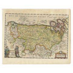
View AllAntique Map of Belgium and Surroundings, 1692
Located in Langweer, NL
Antique map titled 'Provincie Meridionali de Paesi Bassi Intese sotto nome di Fiandra overo Li Paesi Bassi Cattolici con li confini di Francia di Allemagna et di Hollanda'. Uncommon map of Belgium...
Category
Antique 17th Century Maps
Materials
Paper

$407 Sale Price
20% Off
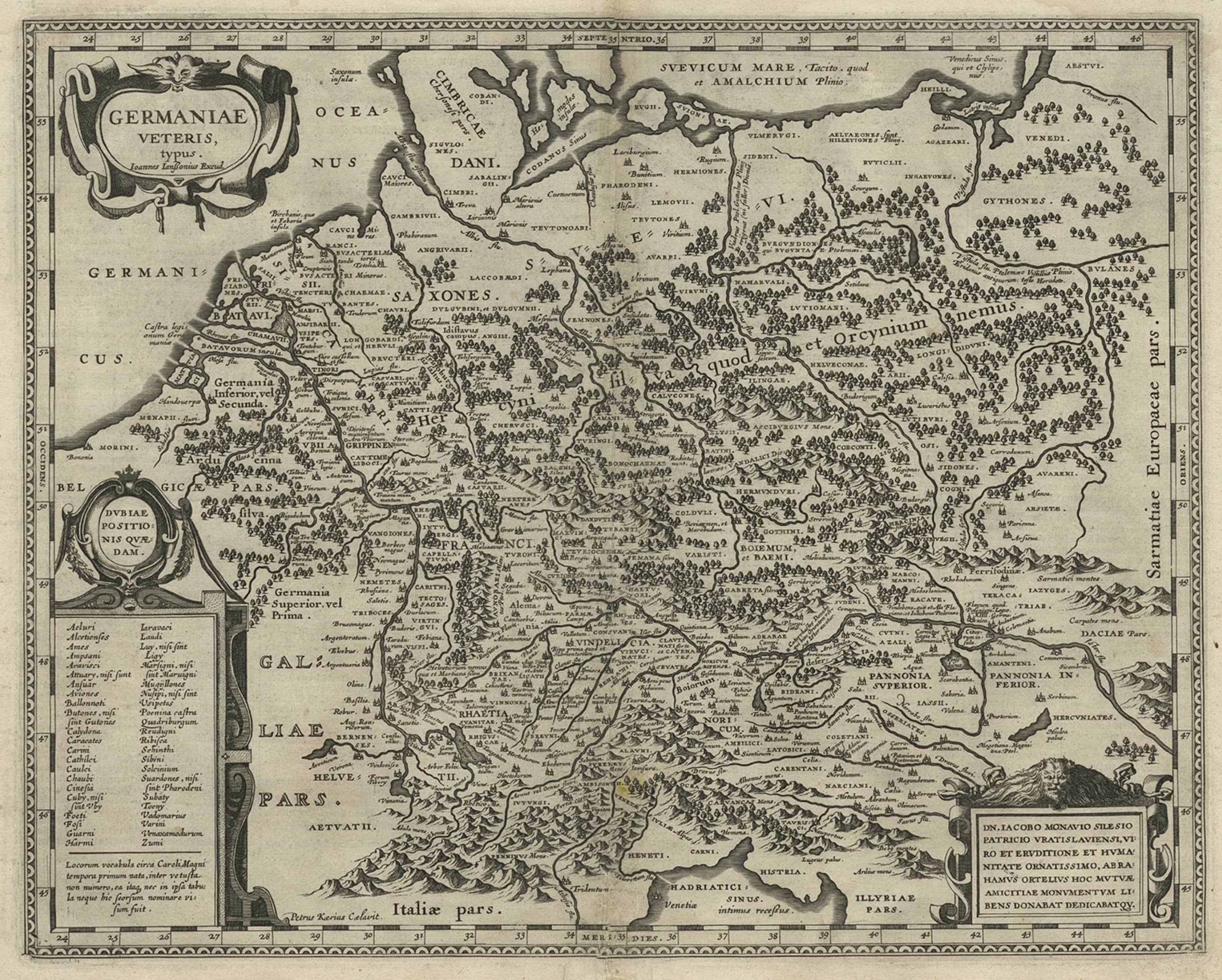
Original Rare Antique Map of the Ancient German Empire in Northern Europe, c1650
Located in Langweer, NL
Antique map titled 'Germaniae Veteris typus.'
Map of the ancient German Empire in Northern Europe, based upon an earlier map by Ortelius. Extends fr...
Category
Antique 1650s Maps
Materials
Paper
$632 Sale Price
20% Off
Antique Map of Germany of German in Roman Times, c.1660
Located in Langweer, NL
Antique map Germany titled 'Germaniae Veteris Typus'. Antique map probably by Blaeu or based on an earlier state by W. Blaeu.
Minor differences shown in the cartouches. Top left ha...
Category
Antique 17th Century Maps
Materials
Paper

$814 Sale Price
20% Off
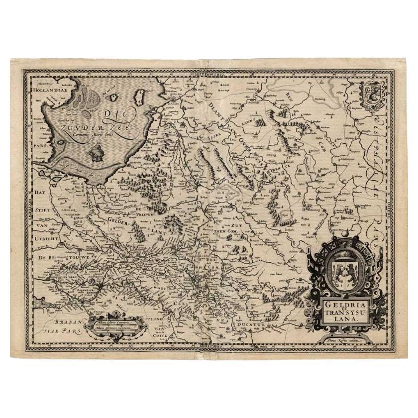
Antique Map of the Provinces of Gelderland and Overijssel by Kaerius, 1617
Located in Langweer, NL
Antique map titled 'Geldria et Transysulana'. Scarse map by Kaerius of the provinces Gelderland and Overijssel in the Netherlands. Large cartouche with coat of arms and sailing ship ...
Category
Antique 17th Century Maps
Materials
Paper
$683 Sale Price
20% Off
Antique Map of the Low Countries by Seutter, c.1745
Located in Langweer, NL
Antique map titled ‘XVII Provinciae Belgii sive Germaniae Inferioris (..)’. Detailed hand colored map of the Low Countries. Includes colored decorative cartouche, compass rose and co...
Category
Antique 18th Century Maps
Materials
Paper

$477 Sale Price
20% Off
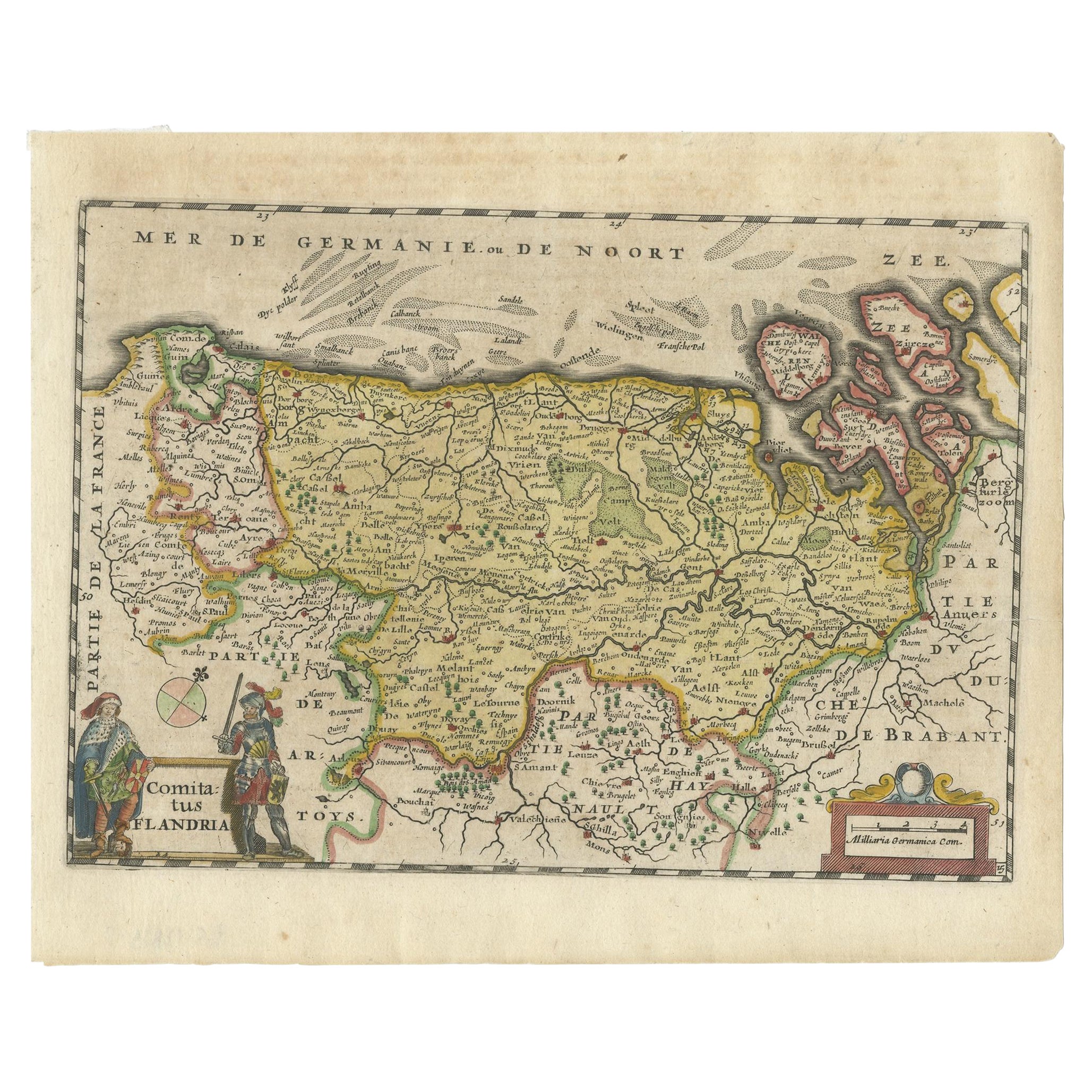
Antique Map of Flanders, Belgium, 1630
Located in Langweer, NL
Antique map titled 'Comitatus Flandria'. Original antique map of Flanders, Belgium. This map originates from 'Vyerige Colom verthonende de 17 Nederlandsche Provintien' published 1630...
Category
Antique 17th Century Maps
Materials
Paper
$431 Sale Price
20% Off
You May Also Like
1643 Willem&Joan Blaeu Map NW Flanders "Flandriae Teutonicae Pars Prientalior
Located in Norton, MA
1643 Willem and Joan Blaeu map of northwest Flanders, entitled
"Flandriae Teutonicae Pars Prientalior,"
Ric0012
" Authentic" - Map of the northwest Fl...
Category
Antique 17th Century Dutch Maps
Materials
Paper

1752 Vaugoundy Map of Flanders : Belgium, France, and the Netherlands, Ric.a002
Located in Norton, MA
Large Vaugoundy Map of Flanders:
Belgium, France, and the Netherlands
Colored -1752
Ric.a002
Description: This is a 1752 Didier Robert de Vaugondy map of Flanders. The map de...
Category
Antique 17th Century Unknown Maps
Materials
Paper

1635 Willem Blaeu Map of Northern France"Comitatvs Bellovacvm" Ric.a08
Located in Norton, MA
1635 Willem Blaeu map of northern France, entitled.
"Comitatvs Bellovacvm Vernacule Beavvais,"
Colored
Ric.a008
“COMITATVS BELLOVACVM…” Amsterdam: W...
Category
Antique 17th Century Unknown Maps
Materials
Paper

17th Century Hand-Colored Map of a Region in West Germany by Janssonius
By Johannes Janssonius
Located in Alamo, CA
This attractive highly detailed 17th century original hand-colored map is entitled "Archiepiscopatus Maghdeburgensis et Anhaltinus Ducatus cum terris adjacentibus". It was published ...
Category
Antique Mid-17th Century Dutch Maps
Materials
Paper

17th Century Hand Colored Map of the Liege Region in Belgium by Visscher
By Nicolaes Visscher II
Located in Alamo, CA
An original 17th century map entitled "Leodiensis Episcopatus in omnes Subjacentes Provincias distincté divisusVisscher, Leodiensis Episcopatus" by Nicolaes Visscher II, published in Amsterdam in 1688. The map is centered on Liege, Belgium, includes the area between Antwerp, Turnhout, Roermond, Cologne, Trier and Dinant.
This attractive map is presented in a cream-colored mat measuring 30" wide x 27.5" high. There is a central fold, as issued. There is minimal spotting in the upper margin and a tiny spot in the right lower margin, which are under the mat. The map is otherwise in excellent condition.
The Visscher family were one of the great cartographic families of the 17th century. Begun by Claes Jansz Visscher...
Category
Antique Late 17th Century Dutch Maps
Materials
Paper

Map of the Netherlands - Etching by G. Braun and F. Hogenberg -Late 16th Century
By Franz Hogenberg
Located in Roma, IT
Map of the Netherlands is an original etching realized by George Braun and Franz Hogenberg, as part of the "Civitates Orbis Terrarum".
The “Civitates Orbis Terrarum” (Atlas of Citi...
Category
16th Century Figurative Prints
Materials
Etching

More Ways To Browse
In Europe
Antique Furniture Dundee
Antique Saudi Arabia
Otto Petri
Serbia Antique Map
Taiwan Map
Antique Maps Colorado
Antique Wooden Roller
Hemisphere Antiques
Map Of Jamaica
Raleigh Antique Furniture
Antique Map Of Colombia
Antique Map Palestine
Vintage Wooden Roller
Antique Constellation Map
Antique Maps Of Cape Of Good Hope
Caucasus Map
Map Of Puerto Rico