Items Similar to Antique Map of the Low Countries by Seutter, c.1745


Want more images or videos?
Request additional images or videos from the seller
1 of 5
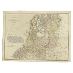
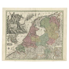
Antique Map of the Low Countries by Seutter, c.1745
About the Item
Antique map titled ‘XVII Provinciae Belgii sive Germaniae Inferioris (..)’. Detailed hand colored map of the Low Countries. Includes colored decorative cartouche, compass rose and coat of arms. Shows political and administrative divisions, cities and towns, place names, rivers and mountains. Relief shown pictorially.
Artists and Engravers: One of the great 18th-century German cartographic families was the Seutters. George Mattaus Seutter the elder was an apprentice to Johann B. Homann, (another great German cartographer who's style was a big influence), in the late 17th century. He left Homann and settled in Augsburg where he set up his own shop. Later joined by his son, Albrecht, who continued the firm in partnership with Tobias C. Lotter upon his fathers death.
Condition: Fair. Age-related toning and some staining. Tears, mostly marginal. Please study image carefully.
Date: c.1745
Overall size: 62 x 53 cm.
Image size: 57.5 x 49 cm.
We sell original antique maps to collectors, historians, educators and interior decorators all over the world. Our collection includes a wide range of authentic antique maps from the 16th to the 20th centuries. Buying and collecting antique maps is a tradition that goes back hundreds of years. Antique maps have proved a richly rewarding investment over the past decade, thanks to a growing appreciation of their unique historical appeal. Today the decorative qualities of antique maps are widely recognized by interior designers who appreciate their beauty and design flexibility. Depending on the individual map, presentation, and context, a rare or antique map can be modern, traditional, abstract, figurative, serious or whimsical. We offer a wide range of authentic antique maps for any budget
- Dimensions:Height: 20.87 in (53 cm)Width: 24.41 in (62 cm)Depth: 0 in (0.01 mm)
- Materials and Techniques:
- Period:
- Date of Manufacture:circa 1745
- Condition:
- Seller Location:Langweer, NL
- Reference Number:
About the Seller
5.0
Platinum Seller
These expertly vetted sellers are 1stDibs' most experienced sellers and are rated highest by our customers.
Established in 2009
1stDibs seller since 2017
1,932 sales on 1stDibs
Typical response time: <1 hour
- ShippingRetrieving quote...Ships From: Langweer, Netherlands
- Return PolicyA return for this item may be initiated within 14 days of delivery.
More From This SellerView All
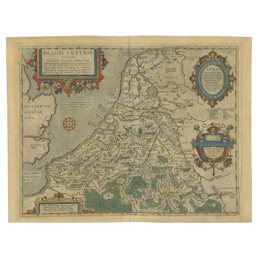
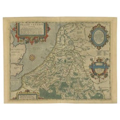
- Antique Map of the Low Countries by Ortelius, 1584By Abraham OrteliusLocated in Langweer, NLAntique map titled 'Belgii Veteris Typus'. Beautiful map of the Low Countries, extending to the English Channel and part of Britain. This map originates from Ortelius' 'Theatrum Orbi...Category
Antique 16th Century Maps
MaterialsPaper
- Antique Map of the Low Countries by Cary, 1813Located in Langweer, NLAntique map of the Netherlands titled 'A New Map of the United Provinces comprehending Holland, Zealand, Utrecht, Gelders, Over Yssel, Friesland and Groningen (..)'. Scarce re-editio...Category
Antique 19th Century Maps
MaterialsPaper
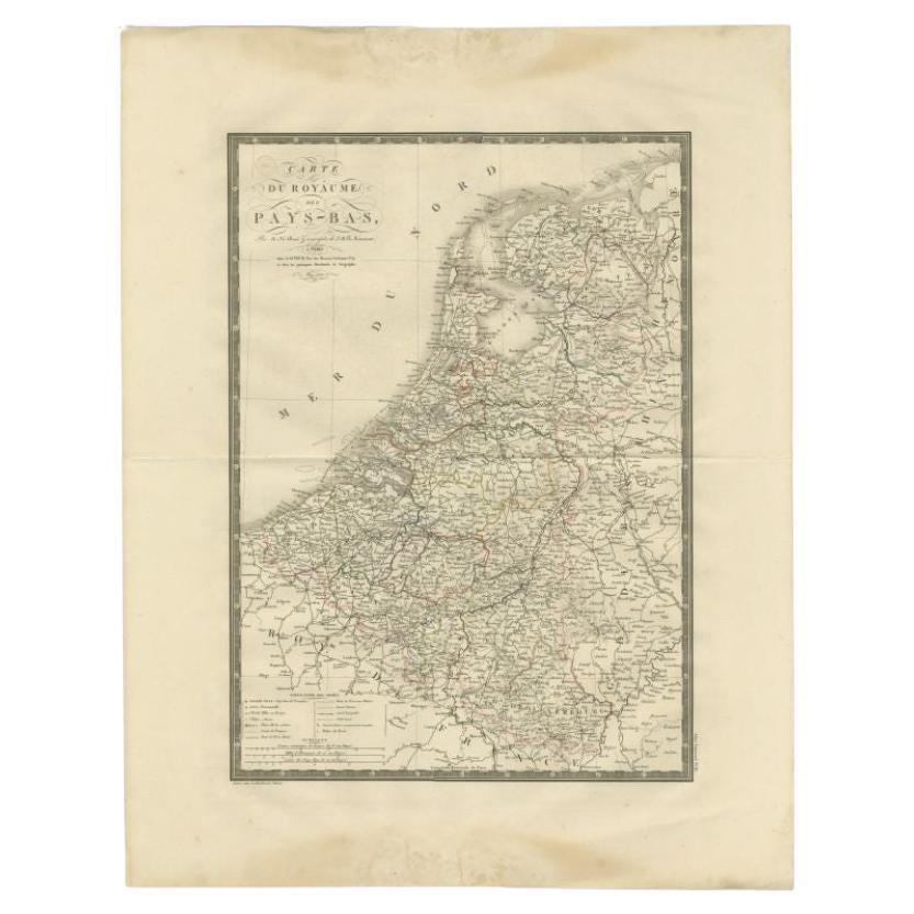
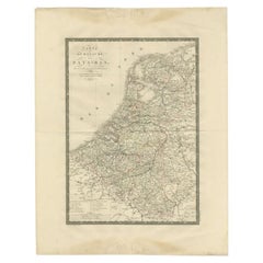
- Antique Map of the Low Countries by Brué, 1822Located in Langweer, NLAntique map titled 'Carte du Royaume des Pays-Bas'. Large format map of the Low Countries. This map originates from 'Atlas Universel', published 1822...Category
Antique 19th Century Maps
MaterialsPaper
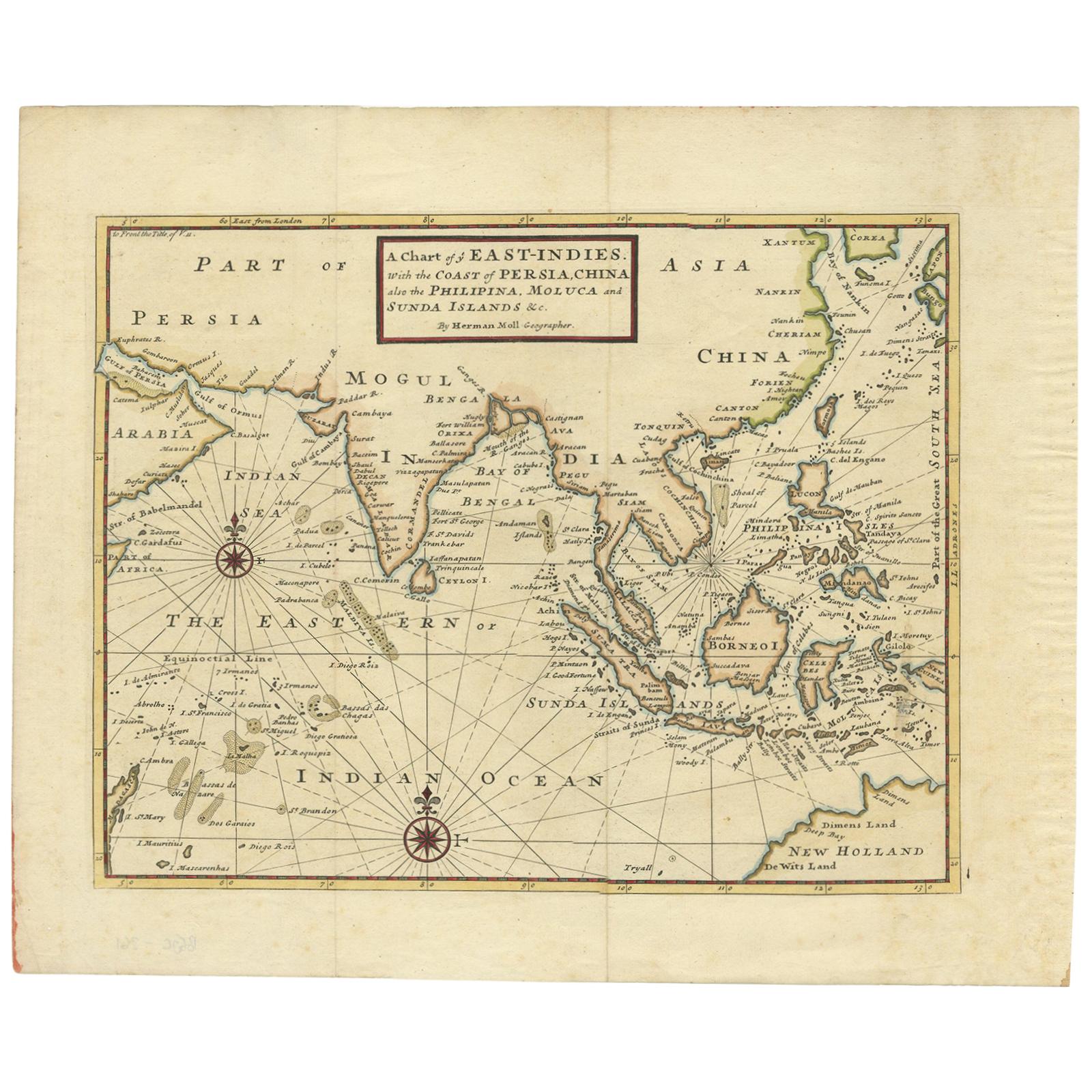
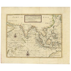
- Antique Map of the East Indies by Moll '1745'Located in Langweer, NLAntique map titled 'A Chart of ye East-Indies. With the Coast of Persia, China also the Philipina, Moluca and Sunda Islands'. Detailed map of the Indian Ocean, Southeast Asia, China,...Category
Antique Mid-18th Century Maps
MaterialsPaper
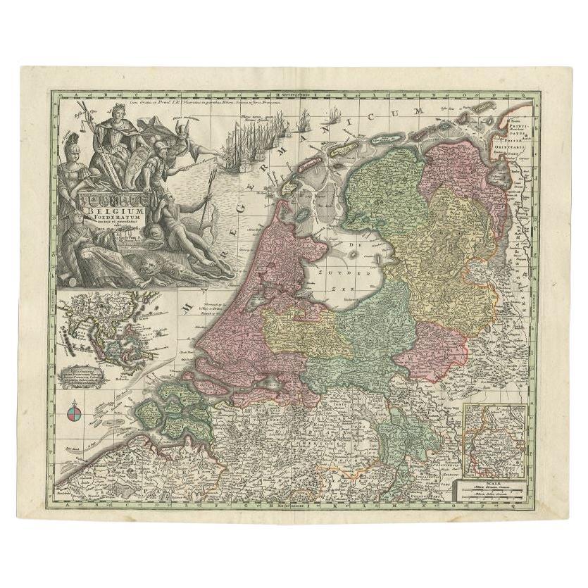
- Antique Map of the Seven United Provinces of Holland by Seutter, 1727Located in Langweer, NLAntique map titled ‘Belgium Foederatum Auctius Et Emendatius‘. Important antique map of the Seven United Provinces of Holland with inset views of the East Indies, the province of Lim...Category
Antique 18th Century Maps
MaterialsPaper
- Antique Map of Northern Germany by M. Seutter, circa 1730By Matthew SeutterLocated in Langweer, NLAntique map titled 'Saxoniae Inferioris Circulus'. Old map of the northern part of Germany by M. Seutter. Covering the area of Lower Saxony, Mecklenburg-Vorpommern and Schleswig-Hols...Category
Antique Mid-18th Century Maps
MaterialsPaper

You May Also Like
- Framed 1731 Color Engraving, Map of Rotterdam by Matthaus Seutter, "Roterodami"Located in Bridgeport, CT"Roterodami". Seutter (1678-1757) was an important German 18th century map maker. Bird's eye view of the city above with full details, neoclassi...Category
Antique 18th Century European Renaissance Maps
MaterialsGlass, Wood, Paper
- Matthaus Seutter, Framed 1730 Color Engraving Map of "Belgium Fonderatum"Located in Bridgeport, CTLabel on verso. From Grosser Atlas. The name Belgium comes from the ancient designation "Gallis Belgica". Figural decoration upper left. M. Seutter was a famed German mapmaker in the...Category
Antique 18th Century European Renaissance Maps
MaterialsBrass
- City View of Nuremberg, Germany: An 18th Century Hand-Colored Map by M. SeutterBy Matthew SeutterLocated in Alamo, CAAn 18th century hand-colored city view of Nuremburg, Germany entitled "Geometrischer Grundris der des Heiligen Römischen Reichs Freyen Stadt Nürnberg" by Matthaus Seutter from his "A...Category
Antique Mid-18th Century German Maps
MaterialsPaper
- 1861 Topographical Map of the District of Columbia, by Boschke, Antique MapLocated in Colorado Springs, COPresented is an original map of Albert Boschke's extremely sought-after "Topographical Map of the District of Columbia Surveyed in the Years 1856 ...Category
Antique 1860s American Historical Memorabilia
MaterialsPaper
- Gold Leaf Foil Pictorial Plan Map of the West Country of England Antique StyleLocated in GBWe are delighted to offer for sale this lovely Antique style pictorial plan map of the West Country of England etched in gold leaf foil This is a very interesting and decorative p...Category
20th Century English Adam Style Maps
MaterialsGold Leaf
- Framed Engraving By Matthaus Seutter Of Sphaerae ArtificialesLocated in Essex, MACartographer from Germany 1678-1757. Hand colored. Gilt wood frame. Estate of William Hodgins.Category
Antique Early 1700s German Prints
MaterialsPaper


Recently Viewed
View AllMore Ways To Browse
Low Country Furniture
Antique And Collectible Shop
Antique Curiosity Shop
Antique Apprentice
Antique Apprentice Furniture
German 18th C
Map With Relief
Political Map
Tobias Antique
Antique Compass Set
Low Relief Abstract
16th Century Hand Colored Map
German Compass
Antique Style Map Of The World
World Map Antique Style
World Maps Antique Style
Relief Map
Antique German Compass