Items Similar to Antique Map of the Low Countries by Ortelius, 1584


Want more images or videos?
Request additional images or videos from the seller
1 of 5
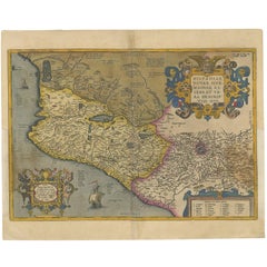
Antique Map of the Low Countries by Ortelius, 1584
About the Item
Antique map titled 'Belgii Veteris Typus'. Beautiful map of the Low Countries, extending to the English Channel and part of Britain. This map originates from Ortelius' 'Theatrum Orbis Terrarum'.
Artists and Engravers: Abraham Ortelius (1527-1598) was, along with Gerard Mercator, the most important cartographer of the 16th century. His 'Theatrum Orbis Terrarum' is considered to be the first true modern atlas. It was the best available summary of 16th-century cartographic knowledge, covering much of the exploration of the world in the century following the discovery of America.
Condition: Fair, age-related toning. Repair on folding line and a tear at the bottom of the map. Latin text on verso, please study image carefully.
Date: 1584
Overall size: 54 x 41.5 cm.
Image size: 48.5 x 38 cm.
We sell original antique maps to collectors, historians, educators and interior decorators all over the world. Our collection includes a wide range of authentic antique maps from the 16th to the 20th centuries. Buying and collecting antique maps is a tradition that goes back hundreds of years. Antique maps have proved a richly rewarding investment over the past decade, thanks to a growing appreciation of their unique historical appeal. Today the decorative qualities of antique maps are widely recognized by interior designers who appreciate their beauty and design flexibility. Depending on the individual map, presentation, and context, a rare or antique map can be modern, traditional, abstract, figurative, serious or whimsical. We offer a wide range of authentic antique maps for any budget.
- Creator:Abraham Ortelius (Artist)
- Dimensions:Height: 16.34 in (41.5 cm)Width: 21.26 in (54 cm)Depth: 0 in (0.01 mm)
- Materials and Techniques:
- Period:
- Date of Manufacture:1584
- Condition:
- Seller Location:Langweer, NL
- Reference Number:
About the Seller
5.0
Platinum Seller
These expertly vetted sellers are 1stDibs' most experienced sellers and are rated highest by our customers.
Established in 2009
1stDibs seller since 2017
1,922 sales on 1stDibs
Typical response time: <1 hour
- ShippingRetrieving quote...Ships From: Langweer, Netherlands
- Return PolicyA return for this item may be initiated within 14 days of delivery.
More From This SellerView All
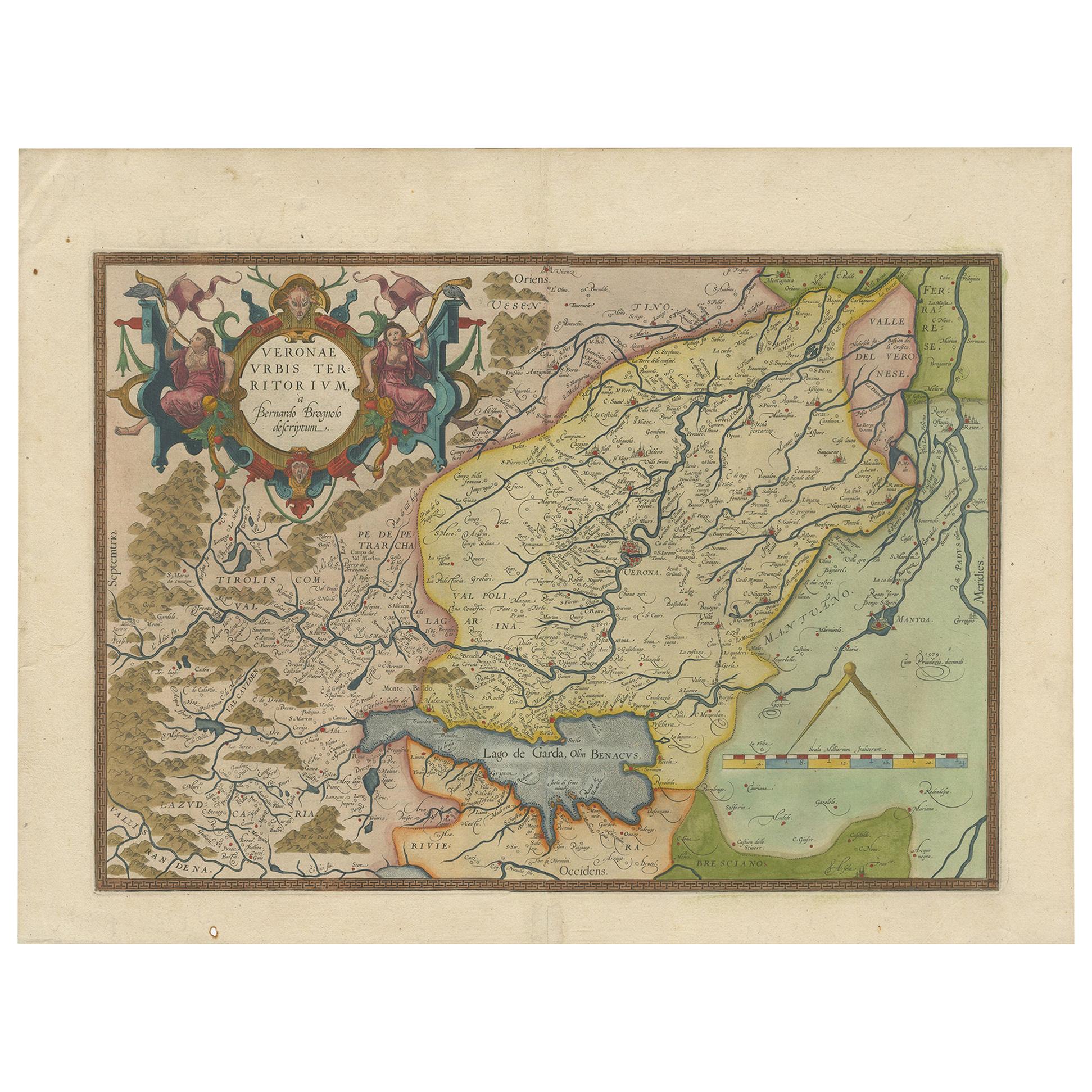
- Antique Map of the Region of Verona 'Italy' by Ortelius, circa 1584Located in Langweer, NLAntique map titled 'Veronae Urbis Terratorium'. Original antique map of the Verona region, Italy. Centered on Verona, and including Mantua, and Lago de Garda. Published by A. Orteliu...Category
Antique Late 19th Century Maps
MaterialsPaper
- Antique Map of Southeast Asia by Ortelius '1587'By Abraham OrteliusLocated in Langweer, NLAntique map titled 'Indiae Orientalis Insularumque Adiacientium Typus'. Ortelius includes early European depictions of both Japan and China and is the first to name Formosa (Taiwan). The Philippines and East Indies or Spice Islands are shown based upon Portuguese and Spanish sources, and before their penetration by the Dutch. Japan is shown in kite form, as a large oval island...Category
Antique 16th Century Maps
MaterialsPaper

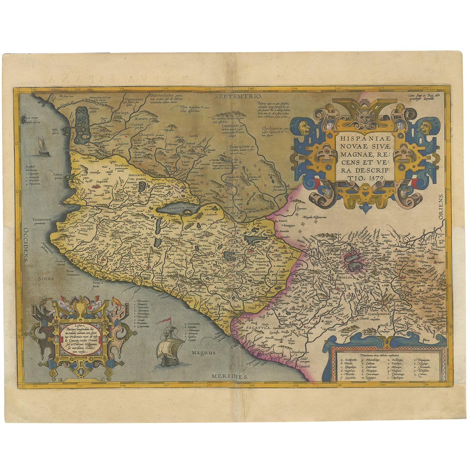
- Antique Map of Mexico by Ortelius, circa 1602By Abraham OrteliusLocated in Langweer, NLAntique map titled 'Hispaniae Novae Sivae Magnae Recens Et Vera Descriptio 1579'. Map of western New Spain, showing the recently-created Spanish settlements, many rivers, and large l...Category
Antique Early 17th Century Belgian Maps
MaterialsPaper
- Antique Map of the Low Countries by Seutter, c.1745Located in Langweer, NLAntique map titled ‘XVII Provinciae Belgii sive Germaniae Inferioris (..)’. Detailed hand colored map of the Low Countries. Includes colored decorative cartouche, compass rose and co...Category
Antique 18th Century Maps
MaterialsPaper
- Antique Map of the Low Countries by Cary, 1813Located in Langweer, NLAntique map of the Netherlands titled 'A New Map of the United Provinces comprehending Holland, Zealand, Utrecht, Gelders, Over Yssel, Friesland and Groningen (..)'. Scarce re-editio...Category
Antique 19th Century Maps
MaterialsPaper
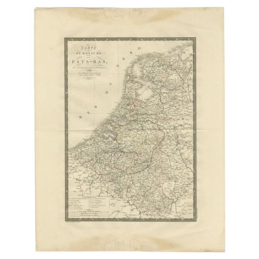
- Antique Map of the Low Countries by Brué, 1822Located in Langweer, NLAntique map titled 'Carte du Royaume des Pays-Bas'. Large format map of the Low Countries. This map originates from 'Atlas Universel', published 1822...Category
Antique 19th Century Maps
MaterialsPaper

You May Also Like
- 1861 Topographical Map of the District of Columbia, by Boschke, Antique MapLocated in Colorado Springs, COPresented is an original map of Albert Boschke's extremely sought-after "Topographical Map of the District of Columbia Surveyed in the Years 1856 ...Category
Antique 1860s American Historical Memorabilia
MaterialsPaper
- Gold Leaf Foil Pictorial Plan Map of the West Country of England Antique StyleLocated in GBWe are delighted to offer for sale this lovely Antique style pictorial plan map of the West Country of England etched in gold leaf foil This is a very interesting and decorative p...Category
20th Century English Adam Style Maps
MaterialsGold Leaf
- 1590 Ortelius Map of Calais and Vermandois, France and Vicinity Ric.a014Located in Norton, MA1590 Ortelius map of Calais and Vermandois, France and Vicinity Ric.a014 Two rare regional Abraham Ortelius maps on a single folio sheet. Left map, entitled Caletensium, depic...Category
Antique 16th Century Dutch Maps
MaterialsPaper
- 1592 Abraham Ortelius Map "Lorraine: Lotharingiae Nova Descripti, Ric.A005Located in Norton, MA1592 Abraham Ortelius map entitled "Lorraine: Lotharingiae Nova Descripti Ric.a005 Description: Ortelius is best known for producing the atlas from which this map comes from, "...Category
Antique 16th Century Dutch Maps
MaterialsPaper
- Original Antique Map of The World by Thomas Clerk, 1817Located in St Annes, LancashireGreat map of The Eastern and Western Hemispheres On 2 sheets Copper-plate engraving Drawn and engraved by Thomas Clerk, Edinburgh. Published by Mackenzie And Dent, 1817 ...Category
Antique 1810s English Maps
MaterialsPaper
- 1907 Map of Colorado, Antique Topographical Map, by Louis NellLocated in Colorado Springs, COThis highly detailed pocket map is a topographical map of the state of Colorado by Louis Nell from 1907. The map "has been complied from all availabl...Category
Antique Early 1900s American Maps
MaterialsPaper


Recently Viewed
View AllMore Ways To Browse
Country English Antiques
Low Country Furniture
16th Century English
English 16th Century Furniture
16th Century English Antique
Latin America Antique
Antique Map Ortelius
Antique Maps Ortelius
Pediment Metal
Russian Antique Book
Antique In The Philippines
Antique Furniture In Philippines
Antique Nursery
Medieval Plate
Atlas Globe
Antique Depot
Chinese Antique Map
Kings Court