Items Similar to Antique Map of the North Sea From the English Channel to Norway & Sweden, 1746


Want more images or videos?
Request additional images or videos from the seller
1 of 8
Antique Map of the North Sea From the English Channel to Norway & Sweden, 1746
$470.08
$587.6020% Off
£349.69
£437.1120% Off
€392
€49020% Off
CA$643.70
CA$804.6220% Off
A$715.70
A$894.6320% Off
CHF 373.70
CHF 467.1320% Off
MX$8,711.86
MX$10,889.8320% Off
NOK 4,768.27
NOK 5,960.3320% Off
SEK 4,467.64
SEK 5,584.5520% Off
DKK 2,984.08
DKK 3,730.1020% Off
Shipping
Retrieving quote...The 1stDibs Promise:
Authenticity Guarantee,
Money-Back Guarantee,
24-Hour Cancellation
About the Item
Antique map titled 'A correct Chart of the German Ocean from the North of Scotland to the Start Point, on the Coast of Great Britain; and from So. Bygden on ye coast of Norway, to C. de la Hogue on ye Coast of Normandy in France'.
This map depicts the region from the English Channel to Norway and Sweden.
Artists and Engravers: Engraved by R.W. Seale.
- Dimensions:Height: 20.08 in (51 cm)Width: 15.75 in (40 cm)Depth: 0 in (0.02 mm)
- Materials and Techniques:
- Period:1740-1749
- Date of Manufacture:1746
- Condition:Condition: Good. Some tears, mainly along folding lines. Please study image carefully.
- Seller Location:Langweer, NL
- Reference Number:Seller: BG-07968 1stDibs: LU3054327423012
About the Seller
5.0
Recognized Seller
These prestigious sellers are industry leaders and represent the highest echelon for item quality and design.
Platinum Seller
Premium sellers with a 4.7+ rating and 24-hour response times
Established in 2009
1stDibs seller since 2017
2,511 sales on 1stDibs
Typical response time: <1 hour
- ShippingRetrieving quote...Shipping from: Langweer, Netherlands
- Return Policy
Authenticity Guarantee
In the unlikely event there’s an issue with an item’s authenticity, contact us within 1 year for a full refund. DetailsMoney-Back Guarantee
If your item is not as described, is damaged in transit, or does not arrive, contact us within 7 days for a full refund. Details24-Hour Cancellation
You have a 24-hour grace period in which to reconsider your purchase, with no questions asked.Vetted Professional Sellers
Our world-class sellers must adhere to strict standards for service and quality, maintaining the integrity of our listings.Price-Match Guarantee
If you find that a seller listed the same item for a lower price elsewhere, we’ll match it.Trusted Global Delivery
Our best-in-class carrier network provides specialized shipping options worldwide, including custom delivery.More From This Seller
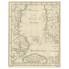
View AllOld Map of the Gulf of Bothnia, the Northernmost Arm of the Baltic Sea, 1759
Located in Langweer, NL
Antique map titled 'Carte du Golphe de Bothnie'.
Original antique map of the Gulf of Bothnia, the northernmost arm of the Baltic Sea. It is situated between Finland's west coast ...
Category
Antique 1750s Maps
Materials
Paper
$230 Sale Price
20% Off
Antique Map of Scandinavia by T. Jefferys, circa 1750
Located in Langweer, NL
Antique map titled 'Sweden, Denmark, Norway & Finland'. An original mid-18th century copper engraved antique map of Scandinavia by Thomas Jefferys....
Category
Antique Mid-18th Century Maps
Materials
Paper

$182 Sale Price
20% Off
Antique Map of Denmark with Schleswig-Holstein and the South of Sweden, c.1750
Located in Langweer, NL
Antique map titled 'General Charte von Konigreich Daenemark nebst dem Herzogthum Holstein.' Denmark with Schleswig-Holstein and the southern coast of Sweden. The large title cartouch...
Category
Antique 18th Century Maps
Materials
Paper

$354 Sale Price
20% Off
Antique Map of Denmark and Southern Sweden, c.1658
Located in Langweer, NL
Antique map titled 'Royaume de Danemarq.' Map centered on Sjaelland and covers all of Denmark and part of southern Sweden where a dramatic title cartouche obscures the interior. Sour...
Category
Antique 17th Century Maps
Materials
Paper

$259 Sale Price
20% Off
Antique Map of Denmark by Moll 'circa 1730'
By Herman Moll
Located in Langweer, NL
Antique map titled 'Denmark, agreeable to Modern History'. Uncommon map of Denmark by Herman Moll, published, circa 1730.
Category
Antique Mid-18th Century Maps
Materials
Paper

$335 Sale Price
20% Off
Antique Map of Scandinavia by Van der Aa 'circa 1710'
Located in Langweer, NL
Antique map titled 'Scandinavie Septentrionale' and 'Scandinavie Meridionale'. Copper engraving with two maps on one sheet. The upper map depicts Northern Scandinavia with Norway, Sw...
Category
Antique Early 18th Century Maps
Materials
Paper

$671 Sale Price
20% Off
You May Also Like
Original Antique Map of Sweden, Engraved by Barlow, 1806
Located in St Annes, Lancashire
Great map of Sweden
Copper-plate engraving by Barlow
Published by Brightly & Kinnersly, Bungay, Suffolk. 1806
Unframed.
Category
Antique Early 1800s English Maps
Materials
Paper

Hand-Colored 18th Century Homann Map of Denmark and Islands in the Baltic Sea
By Johann Baptist Homann
Located in Alamo, CA
An 18th century copper plate hand-colored map entitled "Insulae Danicae in Mari Balthico Sitae utpote Zeelandia, Fionia, Langelandia, Lalandia, Falstria, Fembria Mona" created by Joh...
Category
Antique Early 18th Century German Maps
Materials
Paper

17th Century Map of Denmark by French Cartographer Sanson, Dated 1658
By Nicolas Sanson
Located in Copenhagen, K
17th century map of Denmark by French cartographer Sanson.
Nicolas Sanson (20 December 1600-7 July 1667) was a French cartographer, termed by some the creator of French geography an...
Category
Antique 17th Century French Maps
Materials
Paper

Original Antique Map of Europe, Arrowsmith, 1820
Located in St Annes, Lancashire
Great map of Europe
Drawn under the direction of Arrowsmith.
Copper-plate engraving.
Published by Longman, Hurst, Rees, Orme and Brown, 1820
...
Category
Antique 1820s English Maps
Materials
Paper

Scandinavia & Portions of Eastern Europe: 18th Century Hand-Colored Homann Map
By Johann Baptist Homann
Located in Alamo, CA
An early 18th century hand-colored copper-plate map entitled "Regni Sueciae in omnes suas Subjacentes Provincias accurate divisi Tabula Generalis" by Johann Baptist Homann (1663-1724...
Category
Antique Early 18th Century German Maps
Materials
Paper

1646 Jansson Map Entitled "Procinvia Connactiae, " Ric.a006
Located in Norton, MA
1646 Jansson map entitled
"Procinvia connactiae,"
Ric.a006
Description: The PROVINCE of CONNAVGT 490 x 380From vol 4 of Jansson's Atlas Novus 1646, published in Amsterdam with...
Category
Antique 17th Century Unknown Maps
Materials
Paper

More Ways To Browse
Map Of Normandy
Antique Map Of Thailand
Antique Mississippi Map
Antique Ohio Maps
Burgundy Map
John Speed Maps
Antique Map Of Turkish Empire
Antique Portuguese Scales
Canadian Atlas Furniture
Prussia Map
Afghanistan Map
Malabar Map
Antique Compass Made In France
Antique Maps Dublin
Antique Newfoundland Canada
John Speed Antique Maps
Malaysia Map
Sebastian Munster