Items Similar to Antique Map of Northern England and Wales by Zatta, 1784


Want more images or videos?
Request additional images or videos from the seller
1 of 5
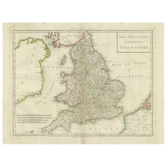
Antique Map of Northern England and Wales by Zatta, 1784
$204.65
$255.8120% Off
£150.72
£188.4020% Off
€170.40
€21320% Off
CA$278.41
CA$348.0120% Off
A$309.37
A$386.7220% Off
CHF 162.11
CHF 202.6420% Off
MX$3,793.90
MX$4,742.3820% Off
NOK 2,067.67
NOK 2,584.5920% Off
SEK 1,945.19
SEK 2,431.4920% Off
DKK 1,297.23
DKK 1,621.5420% Off
Shipping
Retrieving quote...The 1stDibs Promise:
Authenticity Guarantee,
Money-Back Guarantee,
24-Hour Cancellation
About the Item
Antique map titled 'Parte Settentrionale dell' Inghilterra e del Principato di Galles'. Engraved map of the northern part of England and Wales, with title cartouche. Shows political and administrative divisions, towns, villages, forests, mountains and rivers. This print originates from 'Atlante Novissimo, illustrato ed accresciuto sulle osservazioni, e scoperte fatte dai piu' celebri e piu' recenti geografi' by A. Zatta. Artists and Engravers: Antonio Zatta (active 1757-1797) was the most prominent Italian map publisher of the late 18th and early 19th century. His firm, based in Venice, produced maps that mark an important transition from 18th to 19th century cartographic styles.
Artist: Antonio Zatta (active 1757-1797) was the most prominent Italian map publisher of the late 18th and early 19th century. His firm, based in Venice, produced maps that mark an important transition from 18th to 19th century cartographic styles.
Condition: Good, age-related toning. Some wear and soiling. Blank verso, please study image carefully.
Date: 1784
Overall size: 48.5 x 38 cm.
Image size: 0.001 x 40.5 x 31 cm.
Antique prints have long been appreciated for both their aesthetic and investment value. They were the product of engraved, etched or lithographed plates. These plates were handmade out of wood or metal, which required an incredible level of skill, patience and craftsmanship. Whether you have a house with Victorian furniture or more contemporary decor an old engraving can enhance your living space. We offer a wide range of authentic antique prints for any budget.
- Dimensions:Height: 14.97 in (38 cm)Width: 19.1 in (48.5 cm)Depth: 0 in (0.01 mm)
- Materials and Techniques:
- Period:
- Date of Manufacture:1784
- Condition:
- Seller Location:Langweer, NL
- Reference Number:Seller: BG-12426-31stDibs: LU3054327618262
About the Seller
5.0
Recognized Seller
These prestigious sellers are industry leaders and represent the highest echelon for item quality and design.
Platinum Seller
Premium sellers with a 4.7+ rating and 24-hour response times
Established in 2009
1stDibs seller since 2017
2,494 sales on 1stDibs
Typical response time: 1 hour
- ShippingRetrieving quote...Shipping from: Langweer, Netherlands
- Return Policy
Authenticity Guarantee
In the unlikely event there’s an issue with an item’s authenticity, contact us within 1 year for a full refund. DetailsMoney-Back Guarantee
If your item is not as described, is damaged in transit, or does not arrive, contact us within 7 days for a full refund. Details24-Hour Cancellation
You have a 24-hour grace period in which to reconsider your purchase, with no questions asked.Vetted Professional Sellers
Our world-class sellers must adhere to strict standards for service and quality, maintaining the integrity of our listings.Price-Match Guarantee
If you find that a seller listed the same item for a lower price elsewhere, we’ll match it.Trusted Global Delivery
Our best-in-class carrier network provides specialized shipping options worldwide, including custom delivery.More From This Seller
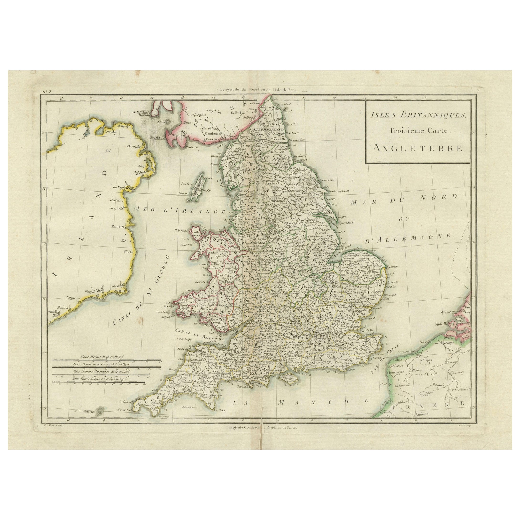
View AllMap of England and Surrounding Regions: Early 19th Century - 1802 Tardieu Atlas
Located in Langweer, NL
Title: Isles Britanniques. Troisieme Carte, Angleterre
Publication Details:
- **Atlas Title:** Nouvel Atlas Universel de Géographie Ancienne et Moderne
- **Purpose:** For the Nouve...
Category
Antique Early 1800s Maps
Materials
Paper
$364 Sale Price
20% Off
Antique Map of England and Ireland by Lattre, 1789
Located in Langweer, NL
Antique map titled 'Les Royaumes d'Angleterre d'Ecosse et d'Irlande'. Original antique map of England and Ireland. Originates from 'Petit Atlas ...
Category
Antique 18th Century Maps
Materials
Paper

$167 Sale Price
20% Off
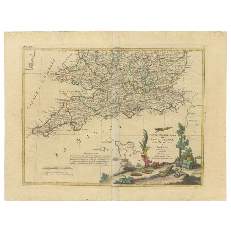
Antique Map of Southern England and Wales by Zatta, 1784
Located in Langweer, NL
"Antique map titled 'Parte Meridionale dell' Inghilterra e del Pricipato di Galles'. Engraved map of the southern part of England and Wales, with title cartouche. Shows political and...
Category
Antique 18th Century Maps
Materials
Paper
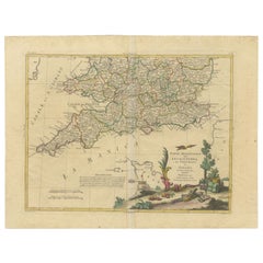
$204 Sale Price
20% Off
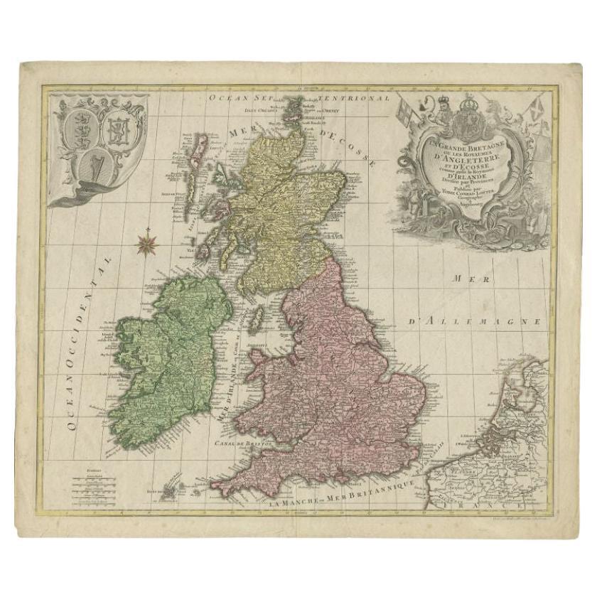
Antique Map of the British Isles by Lotter, 1764
Located in Langweer, NL
Antique map titled 'Le Grand Bretagne ou les Royaumes d'Angleterre et d'Ecosse'. Old engraved map of the British Isles (main islands United Kingdom & Ire...
Category
Antique 18th Century Maps
Materials
Paper
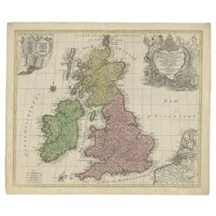
$321 Sale Price
20% Off
Antique Map of England & Wales by Wyld '1845'
Located in Langweer, NL
Antique map titled 'England & Wales'. Original antique map of England & Wales. This map originates from 'An Atlas of the World, Comprehending Se...
Category
Antique Mid-19th Century Maps
Materials
Paper

$135 Sale Price
24% Off
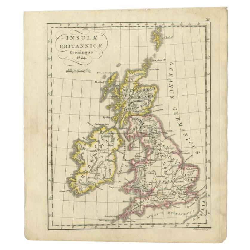
Antique Map of the United Kingdom and Ireland, circa 1825
Located in Langweer, NL
Antique map titled 'Insula Britannicae'. Old map of the United Kingdom and Ireland originating from 'Atlas der Oude Wereld'.
Artists and Engravers: Published by C. Ph. Funke and W. v...
Category
Antique 19th Century Maps
Materials
Paper
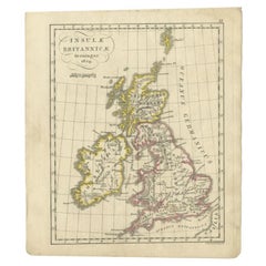
$134 Sale Price
20% Off
You May Also Like
Map Southern Scotland Thomas Conder Alex Hogg 1795
Located in BUNGAY, SUFFOLK
A new map of the southern part of Scotland containing the counties of Stirling, Lanerk, Renfrew, Linlithgow, Edinburgh, Peebles, Haddingtoun, Berwick, Selkirk, Roxburgh, Dumfries, Wigtoun, Kirkudbright & Air
Published by Alex Hogg at the Kings Arms...
Category
Antique 18th Century English Georgian Maps
Materials
Paper

18th Century Emanuel Bowen Map of County of York, c.1740
By Emanuel Bowen
Located in Royal Tunbridge Wells, Kent
Antique 18th century British rare and original Emanuel Bowen (1694-1767) map of the County of York divided into its Ridings and subdivided into wapontakes, mounted in solid wood fram...
Category
Antique Early 18th Century British Maps
Materials
Paper

Old Horizontal Map of England
By Tasso
Located in Alessandria, Piemonte
ST/520 - Old rare Italian map of England, dated 1826-1827 - by Girolamo Tasso, editor in Venise, for the atlas of M.r Le-Sage.
Category
Antique Early 19th Century Italian Other Prints
Materials
Paper

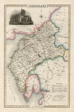
Cumberland, English County Antique map, 1847
By Isaac Slater
Located in Melbourne, Victoria
Steel-engraved map with original outline colouring by Isaac Slater. A detailed engraved map of the English county with title, scale, and key. Decorated with an uncoloured engraved vi...
Category
19th Century Naturalistic Landscape Prints
Materials
Engraving
England, Scotland & Ireland: A Hand Colored Map of Great Britain by Tirion
By Isaak Tirion
Located in Alamo, CA
This is a hand-colored double page copperplate map of Great Britain entitled "Nieuwe Kaart van de Eilanden van Groot Brittannien Behelzende de Kon...
Category
Antique Mid-18th Century Dutch Maps
Materials
Paper

1851 Map of "Independent Tartary", Ric. R018
Located in Norton, MA
1851 Map of
Independent Tartary
"Russia"
Ric.r018
A highly decorative 1851 map of Independent Tartary by John Tallis and John Rapkin. Covers the regions between the Caspian Sea and Lake Bakquash and between Russia and Afghanistan. These include the ancient Silk Route kingdoms of Khiva, Tartaria, Kokand, and Bokhara. Today this region roughly includes Kazakhstan, Uzbekistan, Turkmenistan, Kyrgyzstan, and Tajikistan. This wonderful map offers a wealth of detail for anyone with an interest in the Central Asian portion of the ancient Silk Road. Identifies various caravan routes, deserts, wells, and stopping points, including the cities of Bokhara and Samarkand. Three vignettes by W. Bragg decorate the map, these including an image of Tartars on a Journey, a horseback Bride Chase, and a tartar camp site. Surrounded by a vine motif border. Engraved by J. Rapkin for John Tallis's 1851 Illustrated Atlas .
Tartary Antique Map...
Category
Antique 19th Century Unknown Maps
Materials
Paper

More Ways To Browse
Wales And Wales Furniture
Malabar Map
Antique Compass Made In France
Antique Maps Dublin
Antique Newfoundland Canada
John Speed Antique Maps
Malaysia Map
Sebastian Munster
Antique Map Chile
Antique Map Of Boston
Ipswich Antique Furniture
Maps Balkans
Missouri Map
Antique Maps Of Texas
Antique Maps Virginia
Antique Railroad Scale
Jamaican Antique
Hindeloopen Furniture