Items Similar to Antique Map of England and Ireland by Lattre, 1789


Want more images or videos?
Request additional images or videos from the seller
1 of 5
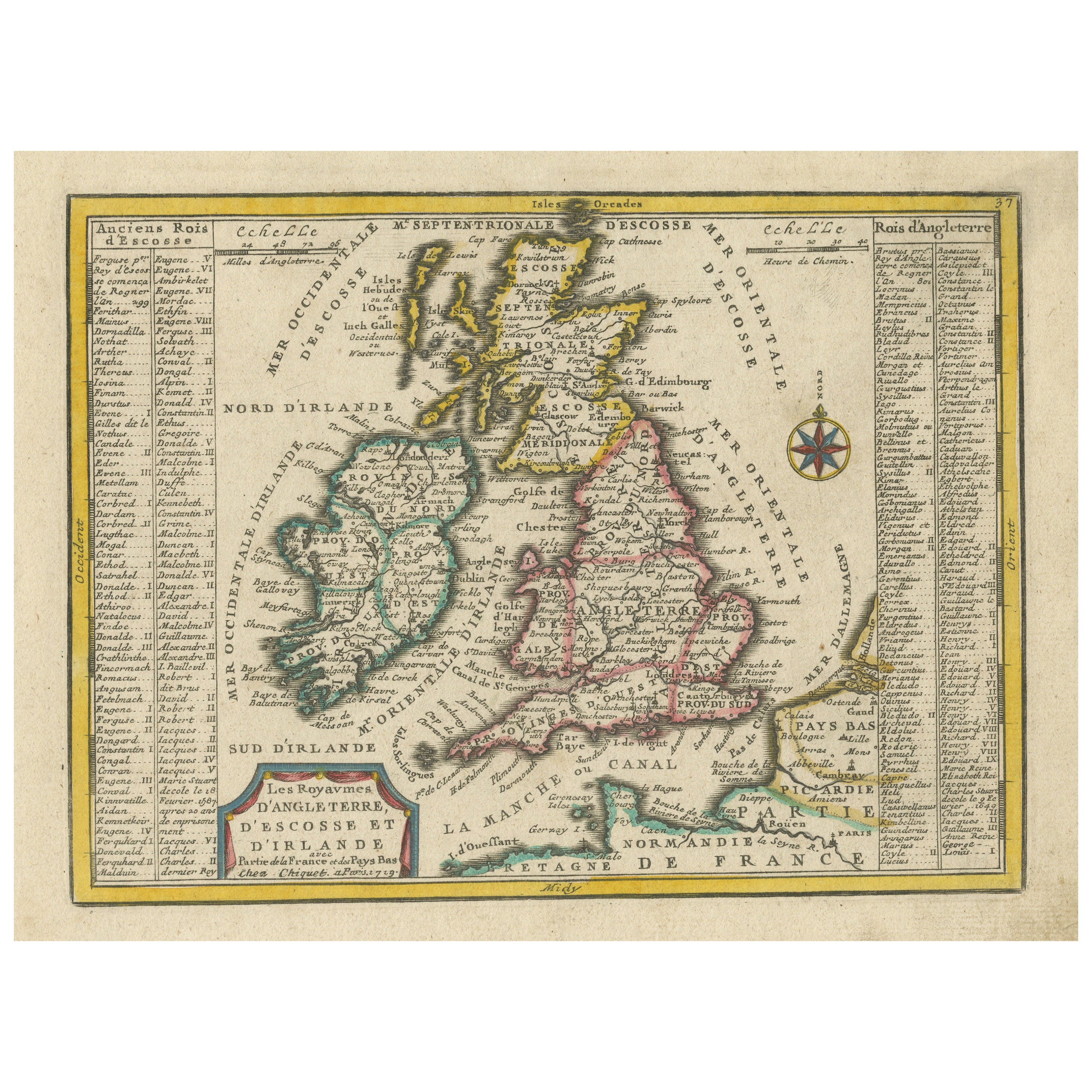
Antique Map of England and Ireland by Lattre, 1789
About the Item
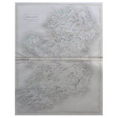
Antique map titled 'Les Royaumes d'Angleterre d'Ecosse et d'Irlande'. Original antique map of England and Ireland. Originates from 'Petit Atlas Moderne ou Collection de Cartes Elementaires'.
Artists and Engravers: Jean Lattre was an 18th. c. French Royal engraver, editor and merchant.
Condition: Good. Small repair on centerfold. Tape on verso. Please study image carefully.
Date: 1789
Overall size: 29 x 21 cm.
Image size: 25 x 18.5 cm.
We sell original antique maps to collectors, historians, educators and interior decorators all over the world. Our collection includes a wide range of authentic antique maps from the 16th to the 20th centuries. Buying and collecting antique maps is a tradition that goes back hundreds of years. Antique maps have proved a richly rewarding investment over the past decade, thanks to a growing appreciation of their unique historical appeal. Today the decorative qualities of antique maps are widely recognized by interior designers who appreciate their beauty and design flexibility. Depending on the individual map, presentation, and context, a rare or antique map can be modern, traditional, abstract, figurative, serious or whimsical. We offer a wide range of authentic antique maps for any budget.
- Dimensions:Height: 8.27 in (21 cm)Width: 11.42 in (29 cm)Depth: 0 in (0.01 mm)
- Materials and Techniques:
- Period:
- Date of Manufacture:1789
- Condition:
- Seller Location:Langweer, NL
- Reference Number:
About the Seller
5.0
Platinum Seller
These expertly vetted sellers are 1stDibs' most experienced sellers and are rated highest by our customers.
Established in 2009
1stDibs seller since 2017
1,916 sales on 1stDibs
Typical response time: <1 hour
- ShippingRetrieving quote...Ships From: Langweer, Netherlands
- Return PolicyA return for this item may be initiated within 14 days of delivery.
More From This SellerView All
- Original Antique Map of England, Ireland, Scotland and WalesLocated in Langweer, NLAntique map titled 'Les Isles Britanniques, ou sont les Royaumes d Angleterre (..)'. Detailed map of England, Ireland, Scotland and Wales, with French coast and part of the Netherlan...Category
Antique Early 18th Century Maps
MaterialsPaper
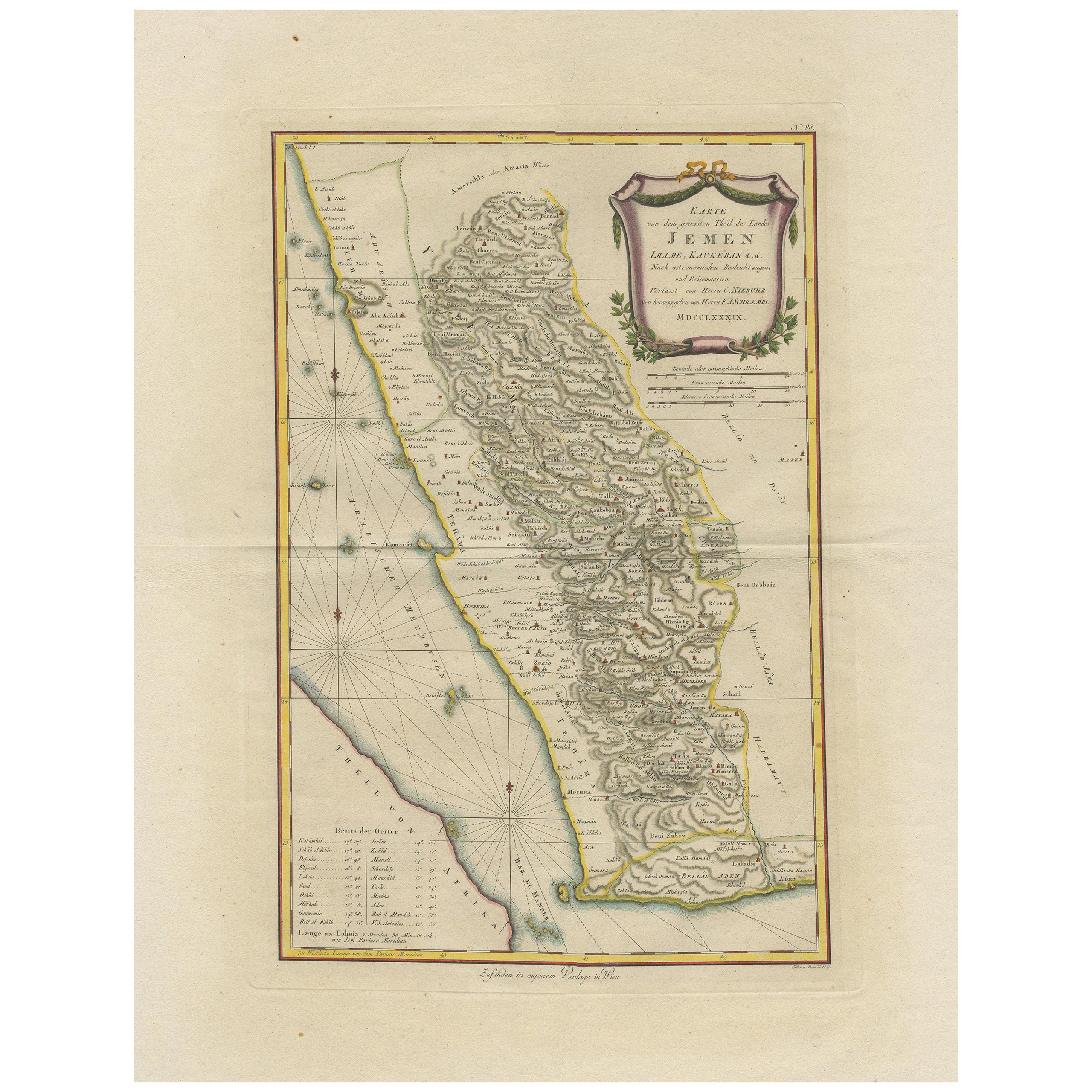
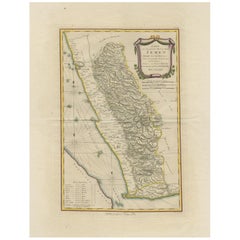
- Antique Map of Yemen by Schraembl, 1789Located in Langweer, NLAntique map titled 'Karte von dem groessten Theil des Landes Jemen'. Original map of Yemen, this map is the first printed map specifically of Yemen, and the earliest map based on act...Category
Antique Late 18th Century Maps
MaterialsPaper
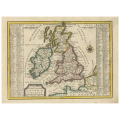
- Small Antique Map of England, Wales, Scotland and Ireland with Original ColoringLocated in Langweer, NLAntique map titled 'Les Royaumes d'Angleterre d'Escosse et d'Irlande (..)'. A lovely, small map of England, Wales, Scotland and Ireland with a portion of the coastline of France and ...Category
Antique Early 18th Century Maps
MaterialsPaper
- Antique Map of England and Wales by Johnson '1872'Located in Langweer, NLAntique map titled 'Johnson's England and Wales'. Original map of England and Wales. This map originates from 'Johnson's New Illustrated Family Atlas of the World' by A.J. Johnson. P...Category
Antique Late 19th Century Maps
MaterialsPaper
- Antique Map of England and Wales by Johnston, 1882Located in Langweer, NLAntique map titled 'England and Wales'. Old map of England and Wales, with an inset map of Scilly Islands. This map originates from 'The Royal Atlas of Modern Geography, Exhibiting, ...Category
Antique 19th Century Maps
MaterialsPaper
- Large Antique Map of England and WalesLocated in Langweer, NLAntique map titled 'An Accurate Map of England and Wales'. Original old map of England and Wales. Engraved by John Cary. Originates from 'New British Atlas' by John Stockdale, publis...Category
Antique Early 19th Century Maps
MaterialsPaper


You May Also Like
- England, Scotland & Ireland: A Hand Colored Map of Great Britain by TirionBy Isaak TirionLocated in Alamo, CAThis is a hand-colored double page copperplate map of Great Britain entitled "Nieuwe Kaart van de Eilanden van Groot Brittannien Behelzende de Kon...Category
Antique Mid-18th Century Dutch Maps
MaterialsPaper
- Original Antique Map of Ireland- Tipperary and Waterford. C.1840Located in St Annes, LancashireGreat map of Tipperary and Waterford Steel engraving Drawn under the direction of A.Adlard Published by How and Parsons, C.1840 Unframed.Category
Antique 1840s English Maps
MaterialsPaper
- Original Antique Map of Ireland- Kerry. C.1840Located in St Annes, LancashireGreat map of Kerry Steel engraving Drawn under the direction of A.Adlard Published by How and Parsons, C.1840 Unframed.Category
Antique 1840s English Maps
MaterialsPaper
- Large Original Antique Map of Ireland by Sidney Hall, 1847Located in St Annes, LancashireGreat map of Ireland Drawn and engraved by Sidney Hall Steel engraving Original colour outline Published by A & C Black. 1847 Unframed Free shipping.Category
Antique 1840s Scottish Maps
MaterialsPaper
- Old Horizontal Map of EnglandBy TassoLocated in Alessandria, PiemonteST/520 - Old rare Italian map of England, dated 1826-1827 - by Girolamo Tasso, editor in Venise, for the atlas of M.r Le-Sage.Category
Antique Early 19th Century Italian Other Prints
MaterialsPaper
- Large Scale Antique Scroll Map of Lincolnshire, England, Dated 1778Located in St Annes, LancashireWonderful scroll map of Lincolnshire By Captain Armstrong, 1778 Copper plate engraving on paper laid on canvas Original ebonized wood frame with lo...Category
Antique 1770s English Georgian Maps
MaterialsWood, Paper


Recently Viewed
View AllMore Ways To Browse
Irish Antiques
Ireland Antiques
England 16th
16th Century England
Antique Map England
Antique Maps England
Antique England Map
Antique Maps Of England
Antique Map Of England
18th Century Merchant
Petit Antiques
Antique French 18th Century Map
Ireland Map
Irish Map
Map Of Ireland
Antique Ireland Maps
Antique Ireland Map
Antique Irish Map