Items Similar to Antique Map of the British Isles by Lotter, 1764


Want more images or videos?
Request additional images or videos from the seller
1 of 5
Antique Map of the British Isles by Lotter, 1764
About the Item
Antique map titled 'Le Grand Bretagne ou les Royaumes d'Angleterre et d'Ecosse'. Old engraved map of the British Isles (main islands United Kingdom & Ireland). Features include a Fine large rococco style title cartouche and another cartouche bearing the shields of the various kingdoms. Artists and Engravers: Tobias Conrad Lotter was born 1717 in Germany. He became a publisher and engraver in Augsburg. He was engaged by Matthias Seutter the elder as an engraver and married his daughter. He also was successful with his own business and became one of the better known German cartographers. After his death in 1777, the business was continued by his son Matthias Albrecht Lotter.
Artist: Tobias Conrad Lotter was born 1717 in Germany. He became a publisher and engraver in Augsburg. He was engaged by Matthias Seutter the elder as an engraver and married his daughter. He also was successful with his own business and became one of the better known German cartographers. After his death in 1777, the business was continued by his son Matthias Albrecht Lotter.
Condition: Fair, general age-related toning. Some wear, few tears repaired. Please study image carefully.
Date: 1764
Overall size: 64 x 54 cm.
Image size: 0.001 x 58 x 49 cm.
Antique prints have long been appreciated for both their aesthetic and investment value. They were the product of engraved, etched or lithographed plates. These plates were handmade out of wood or metal, which required an incredible level of skill, patience and craftsmanship. Whether you have a house with Victorian furniture or more contemporary decor an old engraving can enhance your living space.
- Dimensions:Height: 21.26 in (54 cm)Width: 25.2 in (64 cm)Depth: 0 in (0.01 mm)
- Materials and Techniques:
- Period:
- Date of Manufacture:1764
- Condition:
- Seller Location:Langweer, NL
- Reference Number:
About the Seller
5.0
Platinum Seller
These expertly vetted sellers are 1stDibs' most experienced sellers and are rated highest by our customers.
Established in 2009
1stDibs seller since 2017
1,922 sales on 1stDibs
Typical response time: <1 hour
- ShippingRetrieving quote...Ships From: Langweer, Netherlands
- Return PolicyA return for this item may be initiated within 14 days of delivery.
More From This SellerView All
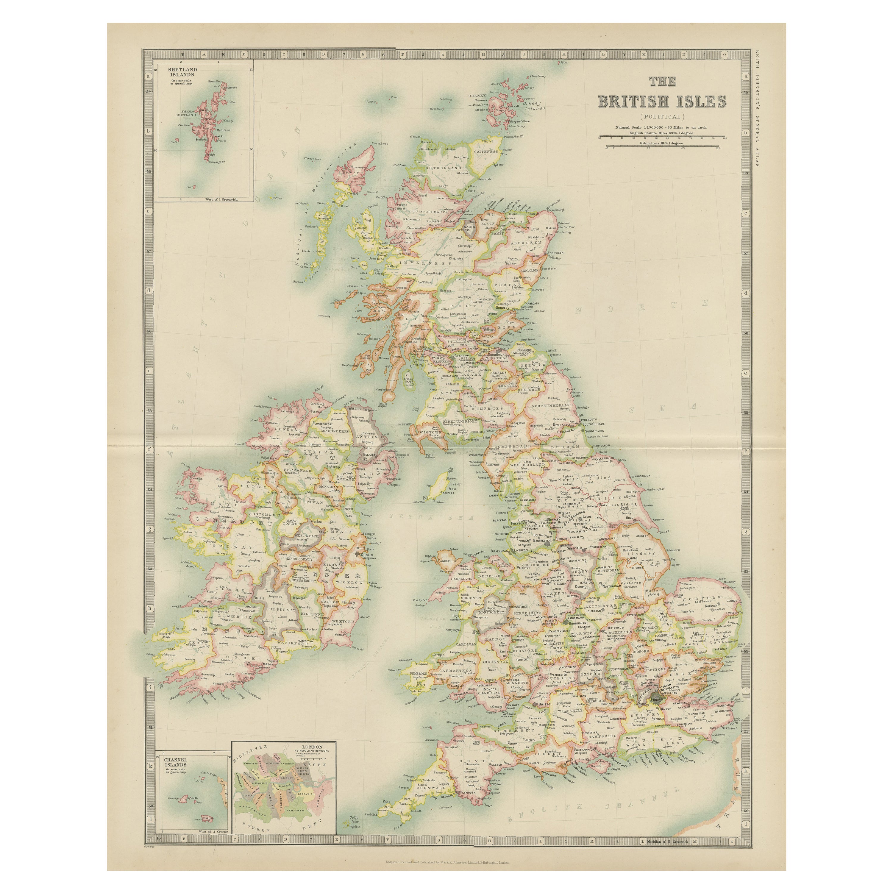
- Antique Map of the British Isles by Johnston '1909'Located in Langweer, NLAntique map titled 'The British Isles'. Original antique map of the British Isles. With inset maps of the Shetland Islands, Chanel Islands, and London. T...Category
Early 20th Century Maps
MaterialsPaper
- Antique Map of the British Isles by Balbi '1847'Located in Langweer, NLAntique map titled 'Iles Britanniques'. Original antique map of the British Isles. This map originates from 'Abrégé de Géographie (..)' by Adrien Balbi. ...Category
Antique Mid-19th Century Maps
MaterialsPaper
- Antique Map of the British Isles by H. Chatelain, 1719By Henri-Abraham ChatelainLocated in Langweer, NLBeautiful hand colored large format map of the British Isles, with large insets of the Eastern and Western Hemispheres and the coats of arms for Engl...Category
Antique Early 18th Century Maps
MaterialsPaper
- Antique Map of the British Isles by Delamarche, 1806Located in Langweer, NLAntique map titled 'Les Isles Britanniques.' Decorative map of the British Isles by Robert de Vaugondy, revised and published by Delamarche. Source unkno...Category
Antique 19th Century Maps
MaterialsPaper
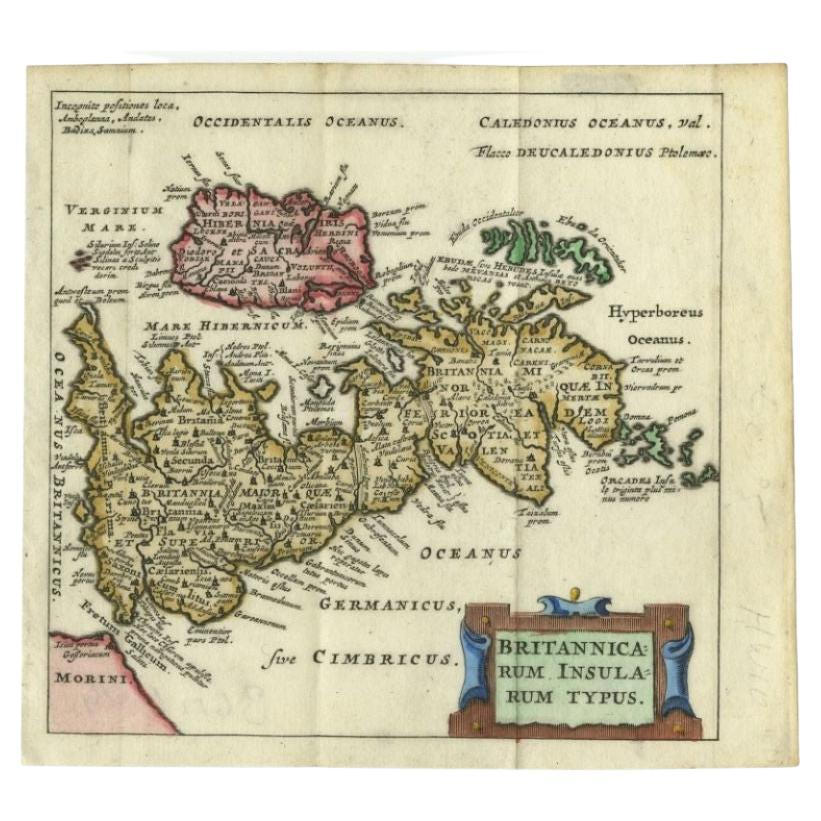
- Antique Map of the British Isles by Cluver, 1685Located in Langweer, NLAntique map titled 'Britannicarum Insularum Typus.' Charming miniature map of the British Islands from the pocket atlas 'Introductionis in Universam Geographiam tam Veterem quam nova...Category
Antique 17th Century Maps
MaterialsPaper
- Antique Map of the British Isles by Covens & Mortier, 1730By Covens & MortierLocated in Langweer, NLCovens and Mortier's attractive double-page engraved map of the British Isles, based on the 1702 De L'Isle map. The map features a large car...Category
Antique Mid-18th Century Maps
MaterialsPaper


You May Also Like
- Large 17th Century Hand Colored Map of England and the British Isles by de WitBy Frederick de WitLocated in Alamo, CAA large hand colored 17th century map of England and the British Isles by Frederick de Wit entitled "Accuratissima Angliæ Regni et Walliæ Principatus", published in Amsterdam in 1680. It is a highly detailed map of England, Scotland, the Scottish Isles...Category
Antique Late 17th Century Dutch Maps
MaterialsPaper
- Antique Book, Birds Of The British Isles, English, Ornithology Reference, C.1920Located in Hele, Devon, GBThis is an antique illustrated book of The Birds of the British Isles. An English, bound ornithology reference title, dating to the early 20th century, published 1920. Full Title - ...Category
Early 20th Century European Mid-Century Modern Books
MaterialsLeather, Paper
- Antique Lithography Map, Isle of Wight, English, Framed, Engraving, CartographyLocated in Hele, Devon, GBThis is an antique lithography map of the Isle of Wight. An English, framed atlas engraving of cartographic interest, dating to the early 19th century and later. Superb lithography ...Category
Antique Early 19th Century British Regency Maps
MaterialsWood
- Antique Lithography Map, Isle of Thanet, Kent, English, Cartography, VictorianLocated in Hele, Devon, GBThis is an antique lithography map of The Isle of Thanet in Kent. An English, framed atlas engraving of cartographic interest, dating to the mid 19th century and later. Superb litho...Category
Antique Mid-19th Century British Victorian Maps
MaterialsWood
- Northwest Coast and Isle of Man MapLocated in Cheshire, GBGreenville Collins Northwest Coast and Isle of Man. hand coloured chart, encased in an ebonised frame. Dimensions Height 26.5 Inches Width 30 Inches Depth 1 InchesCategory
Early 20th Century British Maps
MaterialsPaper
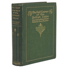
- Golf Book, Bernhard Darwin, Golf Courses of the British IslesLocated in Oxfordshire, GBAntique Golf Book, The Golf Courses of the British Isles Described by Bernard Darwin. A fantastic first edition golf book written by Bernard Darwin, one of the greatest golf writers ever to put pen to paper. 'THE GOLF COURSES OF THE BRITISH ISLES, DESCRIBED BY BERNARD DARWIN, PAINTED BY HARRY ROUNTREE...Category
Vintage 1910s British Sporting Art Books
MaterialsPaper


Recently Viewed
View AllMore Ways To Browse
Antique Furniture Lot
Antique Death
Antique British Plates
Lot Plates
Antique Victorian Lot
Antique German Decor
Maps Of Long Island
Map Of Long Island
Antique Metal Shields
Map Of United Kingdom
Antique Map Britain
Antique Britain Map
18th Century British Antique Print
Map Of Ireland
Ireland Map
Irish Map
Tobias Antique
Irish Decor