Items Similar to Antique Map of the British Isles by Johnston '1909'


Want more images or videos?
Request additional images or videos from the seller
1 of 5
Antique Map of the British Isles by Johnston '1909'
About the Item
Antique map titled 'The British Isles'. Original antique map of the British Isles. With inset maps of the Shetland Islands, Chanel Islands, and London. This map originates from the ‘Royal Atlas of Modern Geography’. Published by W. & A.K. Johnston, 1909.
- Dimensions:Height: 24.41 in (62 cm)Width: 19.49 in (49.5 cm)Depth: 0.02 in (0.5 mm)
- Materials and Techniques:
- Period:
- Date of Manufacture:1909
- Condition:Minor fading. General age-related toning, some foxing. Please study image carefully.
- Seller Location:Langweer, NL
- Reference Number:
About the Seller
5.0
Platinum Seller
These expertly vetted sellers are 1stDibs' most experienced sellers and are rated highest by our customers.
Established in 2009
1stDibs seller since 2017
1,932 sales on 1stDibs
Typical response time: <1 hour
- ShippingRetrieving quote...Ships From: Langweer, Netherlands
- Return PolicyA return for this item may be initiated within 14 days of delivery.
More From This SellerView All
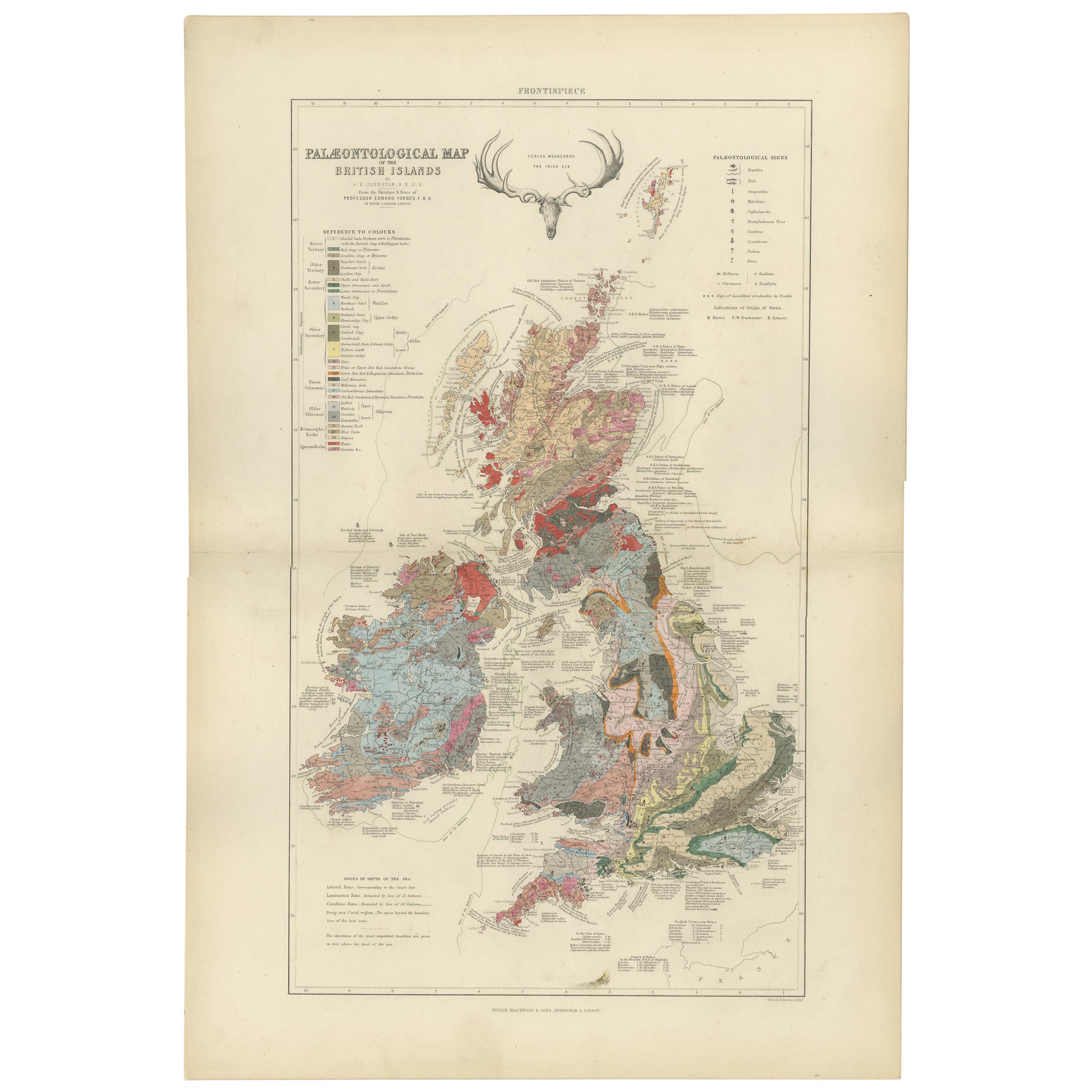
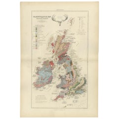
- Antique Map of the Palaeontology of the British Isles by Johnston '1850'Located in Langweer, NLAntique map titled 'Palaeontological Map of the British Islands'. Original antique map showing the palaeontology of the British Isles. This map originates from 'The Physical Atlas of...Category
Antique Mid-19th Century Maps
MaterialsPaper
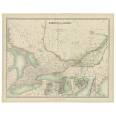
- Antique Map of Canada by Johnston '1909'Located in Langweer, NLAntique map titled 'Dominion of Canada'. Original antique map of Canada. With inset maps of Niagara, Montreal, Quebec. This map originates from t...Category
Early 20th Century Maps
MaterialsPaper
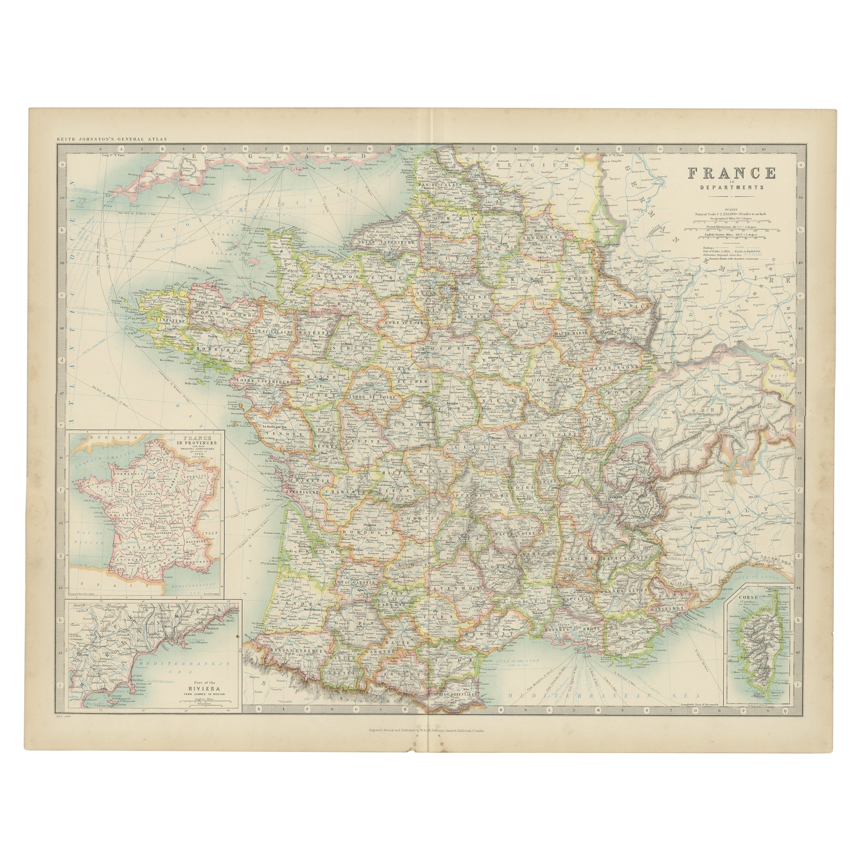
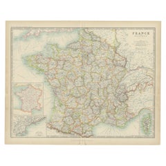
- Antique Map of France by Johnston (1909)Located in Langweer, NLAntique map titled 'France'. Original antique map of France. With inset maps of France in provinces, part of the Riviera and Corsica. This map or...Category
Early 20th Century Maps
MaterialsPaper
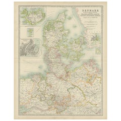
- Antique Map of Denmark by Johnston '1909'Located in Langweer, NLAntique map titled 'Denmark'. Original antique map of Denmark. With inset maps of Iceland, Faroe Island, and Copenhagen. This map originates from the ‘Royal Atlas of Modern Geography...Category
Early 20th Century Maps
MaterialsPaper
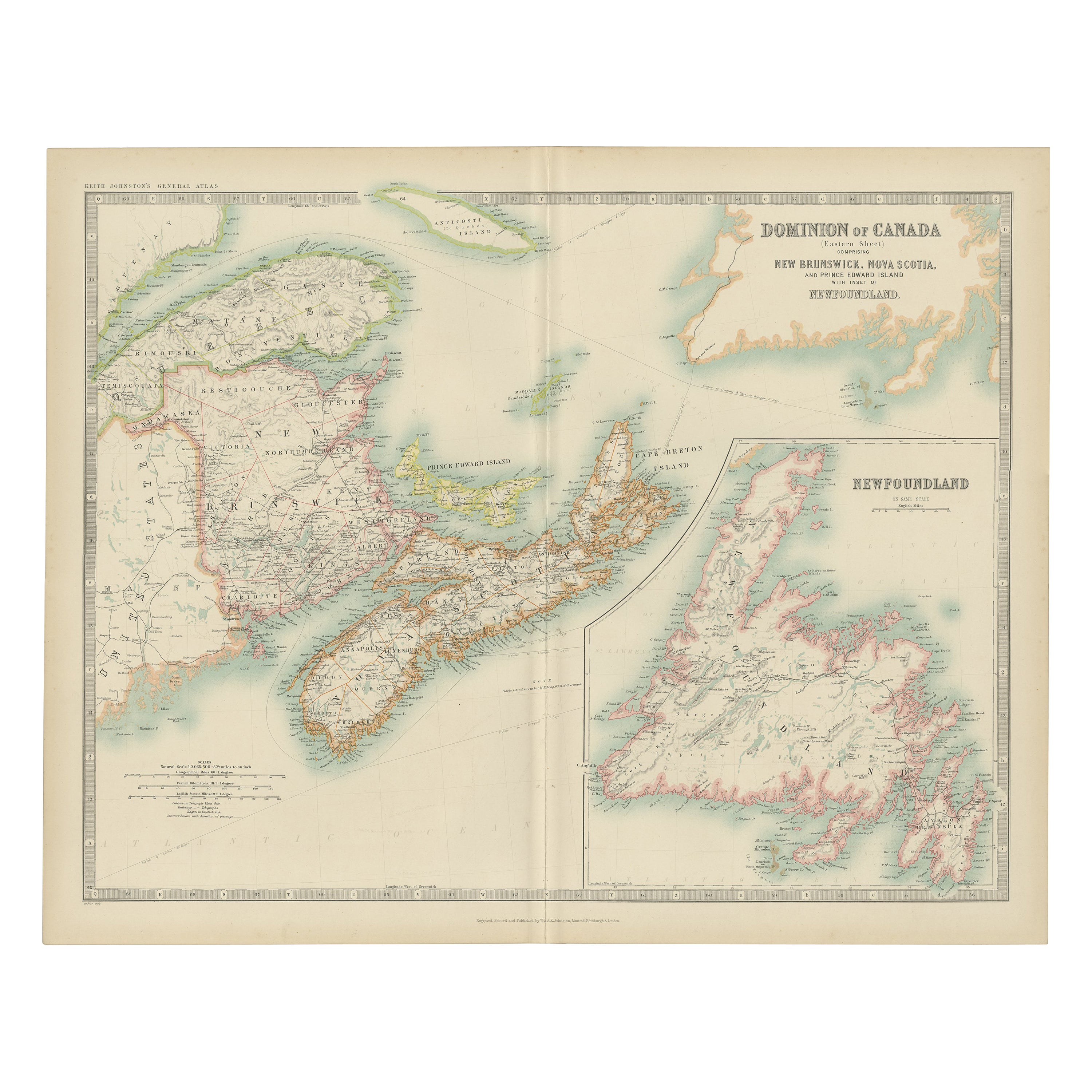
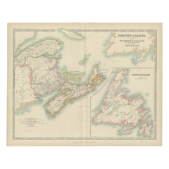
- Antique Map of Canada by Johnston '1909'Located in Langweer, NLAntique map titled 'Dominion of Canada'. Original antique map of Canada. With inset map of Newfoundland. This map originates from the ‘Royal Atla...Category
Early 20th Century Maps
MaterialsPaper
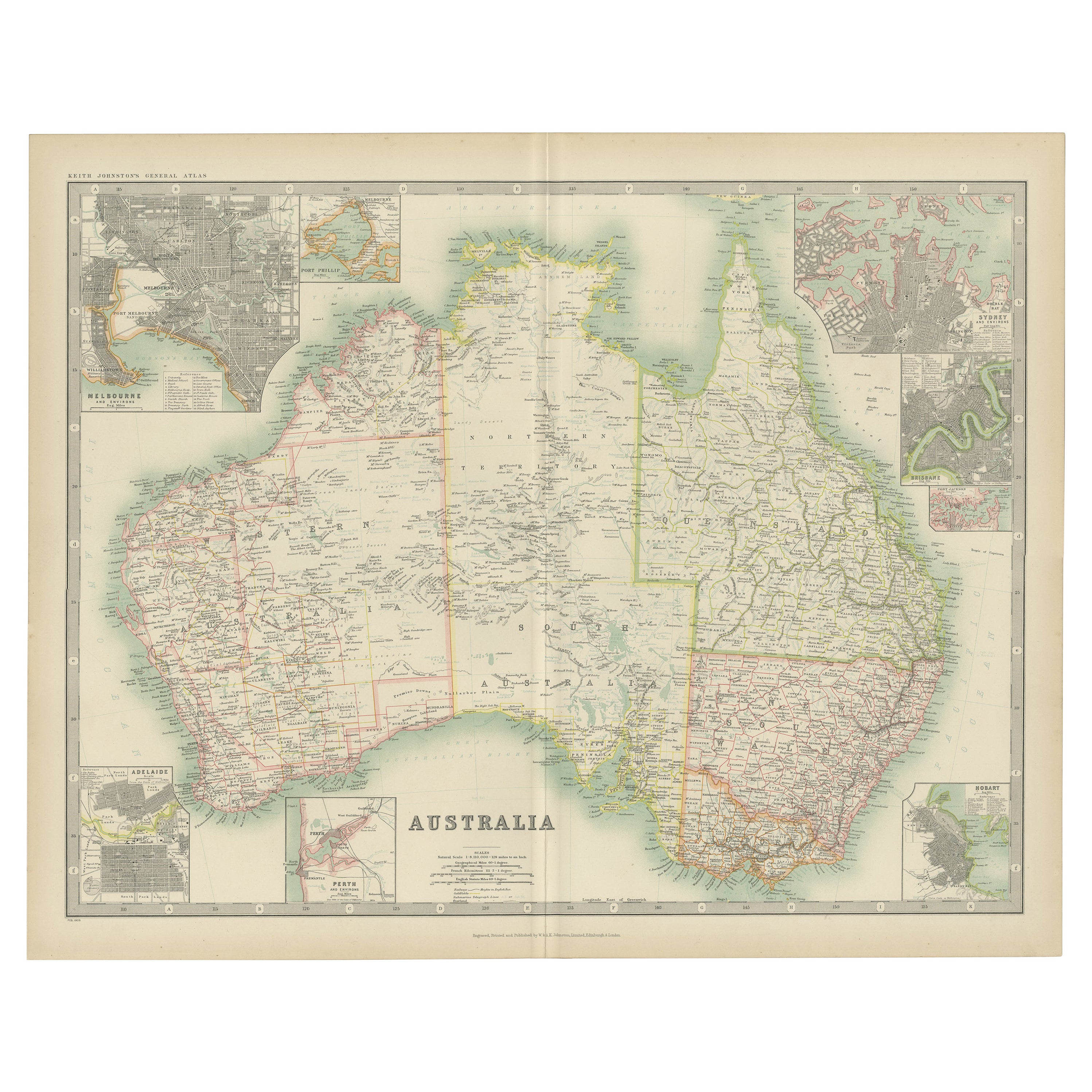
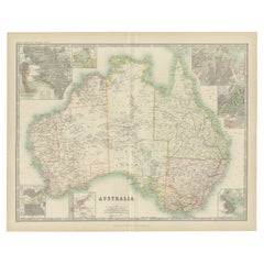
- Antique Map of Australia by Johnston '1909'Located in Langweer, NLAntique map titled 'Australia'. Original antique map of Australia. With inset maps of Melbourne, Port Phillip, Adelaide, Perth, Sydney, Brisba...Category
Early 20th Century Maps
MaterialsPaper
You May Also Like
- Large 17th Century Hand Colored Map of England and the British Isles by de WitBy Frederick de WitLocated in Alamo, CAA large hand colored 17th century map of England and the British Isles by Frederick de Wit entitled "Accuratissima Angliæ Regni et Walliæ Principatus", published in Amsterdam in 1680. It is a highly detailed map of England, Scotland, the Scottish Isles...Category
Antique Late 17th Century Dutch Maps
MaterialsPaper
- Original Antique Map of The Netherlands, Engraved by Barlow, Dated 1807Located in St Annes, LancashireGreat map of Netherlands Copper-plate engraving by Barlow Published by Brightly & Kinnersly, Bungay, Suffolk. Dated 1807 Unframed.Category
Antique Early 1800s English Maps
MaterialsPaper
- Map of the Republic of GenoaLocated in New York, NYFramed antique hand-coloured map of the Republic of Genoa including the duchies of Mantua, Modena, and Parma. Europe, late 18th century. Dimension: 25...Category
Antique Late 18th Century European Maps
- England, Scotland & Ireland: A Hand Colored Map of Great Britain by TirionBy Isaak TirionLocated in Alamo, CAThis is a hand-colored double page copperplate map of Great Britain entitled "Nieuwe Kaart van de Eilanden van Groot Brittannien Behelzende de Kon...Category
Antique Mid-18th Century Dutch Maps
MaterialsPaper
- Antique Map of Italy by Andriveau-Goujon, 1843By Andriveau-GoujonLocated in New York, NYAntique Map of Italy by Andriveau-Goujon, 1843. Map of Italy in two parts by Andriveau-Goujon for the Library of Prince Carini at Palazzo Carini i...Category
Antique 1840s French Maps
MaterialsLinen, Paper
- Antique Map of Principality of MonacoBy Antonio Vallardi EditoreLocated in Alessandria, PiemonteST/619 - "Old Geographical Atlas of Italy - Topographic map of ex-Principality of Monaco" - ediz Vallardi - Milano - A somewhat special edition ---Category
Antique Late 19th Century Italian Other Prints
MaterialsPaper


