Items Similar to Antique Map of the Region of Paris by Homann Heirs, c.1720


Want more images or videos?
Request additional images or videos from the seller
1 of 5
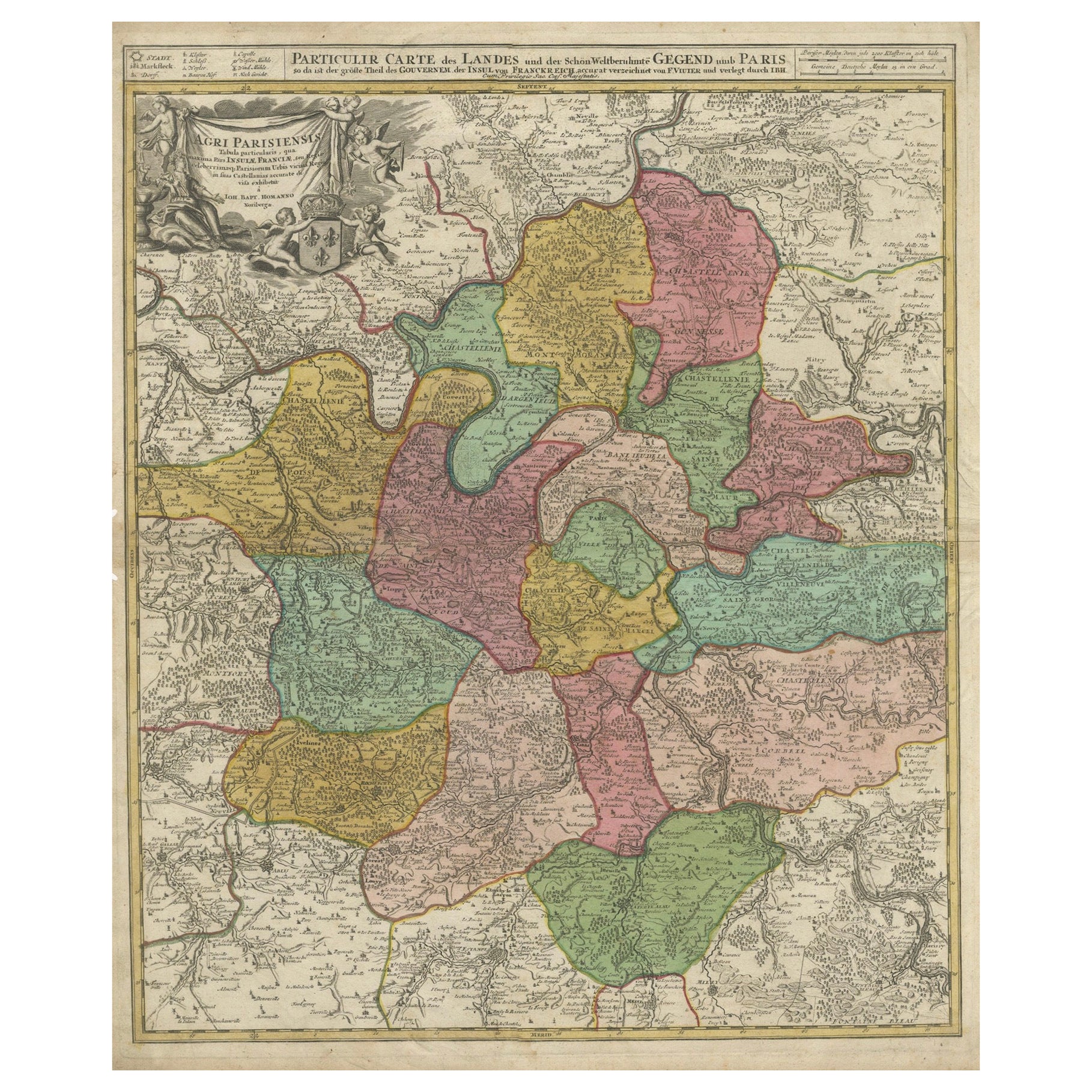
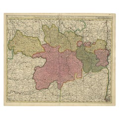
Antique Map of the Region of Paris by Homann Heirs, c.1720
$186.35
$232.9420% Off
£141.16
£176.4620% Off
€160
€20020% Off
CA$258.16
CA$322.7020% Off
A$289.55
A$361.9320% Off
CHF 151.63
CHF 189.5420% Off
MX$3,518.29
MX$4,397.8620% Off
NOK 1,925.47
NOK 2,406.8420% Off
SEK 1,825.48
SEK 2,281.8520% Off
DKK 1,218.20
DKK 1,522.7520% Off
About the Item
Antique map titled 'Agri Parisiensis Tabula particularis, qua maxima Pars Insulae Franciae (..).' Incredibly detailed map showing everything from tiny villages to forests, farmland, walled cities and more. Centered on Paris, the map extends to show these cities at the extremities - Ablis, Messe, Herissy, Senlies, and Mante. Details in Paris includes its fortifications and the gardens at Vincennes. Beautiful cartouche with several putti. Source unknown, to be determined.
Artists and Engravers: Following the long period of Dutch domination, the Homann family became the most important map publishers in Germany in the eighteenth century, the business being founded by J.B. Homann in Nuremberg about the year 1702. Soon after publishing his first atlas in 1707 he became a member of the Berlin academy of Sciences and in 1715 he was appointed Geographer to the Emperor. After the founder's death in 1724, the firm was continued under the direction of his son until 1730 and was then bequeathed to his heirs on the condition that it trades under the name of Homann Heirs. The firm remained in being until the next century and had a wide influence on map publishing in Germany. Apart from the atlases the firm published a very large number of individual maps. The Homanns produced a Neuer Atlas in 1714, a Grosser Atlas in 1737, and an Atlas Maior with about 300 maps in 1780. They also issued a special Atlas of Germany with full sized plans of principal cities, school atlases and an Atlas of Silesia in 1750 with 20 maps.
Condition: Good, given age. Damp stained left and right, mainly visible on verso. Light staining and soiling in the margins. Slight discolouration of paper. Some minor crinkles. Original middle fold as issued. General age-related toning and/or occasional minor defects from handling. Please study image carefully.
Date: c.1720
Overall size: 53.5 x 63 cm.
Image size: 48 x 57.3 cm.
We sell original antique maps to collectors, historians, educators and interior decorators all over the world. Our collection includes a wide range of authentic antique maps from the 16th to the 20th centuries. Buying and collecting antique maps is a tradition that goes back hundreds of years. Antique maps have proved a richly rewarding investment over the past decade, thanks to a growing appreciation of their unique historical appeal. Today the decorative qualities of antique maps are widely recognized by interior designers who appreciate their beauty and design flexibility. Depending on the individual map, presentation, and context, a rare or antique map can be modern, traditional, abstract, figurative, serious or whimsical. We offer a wide range of authentic antique maps for any budget.
- Creator:Homann Heirs (Artist)
- Dimensions:Height: 24.81 in (63 cm)Width: 21.07 in (53.5 cm)Depth: 0 in (0.01 mm)
- Materials and Techniques:
- Period:
- Date of Manufacture:circa 1720
- Condition:
- Seller Location:Langweer, NL
- Reference Number:Seller: PCT-598421stDibs: LU3054327832132
About the Seller
5.0
Recognized Seller
These prestigious sellers are industry leaders and represent the highest echelon for item quality and design.
Platinum Seller
Premium sellers with a 4.7+ rating and 24-hour response times
Established in 2009
1stDibs seller since 2017
2,517 sales on 1stDibs
Typical response time: <1 hour
- ShippingRetrieving quote...Shipping from: Langweer, Netherlands
- Return Policy
Authenticity Guarantee
In the unlikely event there’s an issue with an item’s authenticity, contact us within 1 year for a full refund. DetailsMoney-Back Guarantee
If your item is not as described, is damaged in transit, or does not arrive, contact us within 7 days for a full refund. Details24-Hour Cancellation
You have a 24-hour grace period in which to reconsider your purchase, with no questions asked.Vetted Professional Sellers
Our world-class sellers must adhere to strict standards for service and quality, maintaining the integrity of our listings.Price-Match Guarantee
If you find that a seller listed the same item for a lower price elsewhere, we’ll match it.Trusted Global Delivery
Our best-in-class carrier network provides specialized shipping options worldwide, including custom delivery.More From This Seller
View AllDetailed 18th-Century Map of Paris and Its Surrounding Regions by Johann Homann
Located in Langweer, NL
This map, titled “Agri Parisiensis Tabula particularis,” was created and published by the German cartographer Johann Baptist Homann (1664–1724), or his workshop, in Nuremberg. Homann...
Category
Antique 1720s Maps
Materials
Paper
Antique Map of the Lorraine 'North-East France' by J. B. Homann, circa 1720
Located in Langweer, NL
Antique map of Lorraine in north-east France by J. B. Homann. Covering the area around Metz, Nancy and Sarrebruck with Luxembourg in the North and Mulhouse in Southeast. With a decor...
Category
Antique Early 18th Century Maps
Materials
Paper

$596 Sale Price
20% Off
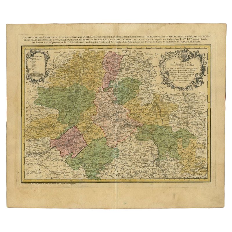
Antique Map of the Region of Orleans by Homann Heirs, c.1760
By Homann Heirs
Located in Langweer, NL
Antique map titled 'Novissima Totius Aureliani Generalitatis (..) - Nouvelle Carte du Gouvernement General et Militaire d'Orleans (..).' Detailed map by Rizzi Zononi covering the vic...
Category
Antique 18th Century Maps
Materials
Paper

$209 Sale Price
20% Off
Antique Map of the Lorraine Region, c.1760
Located in Langweer, NL
Untitled antique map of the Lorraine region, France. A cultural and historical region in north-eastern France, now located in the administrative region of Grand Est. Lorraine's name ...
Category
Antique 18th Century Maps
Materials
Paper

$204 Sale Price
20% Off
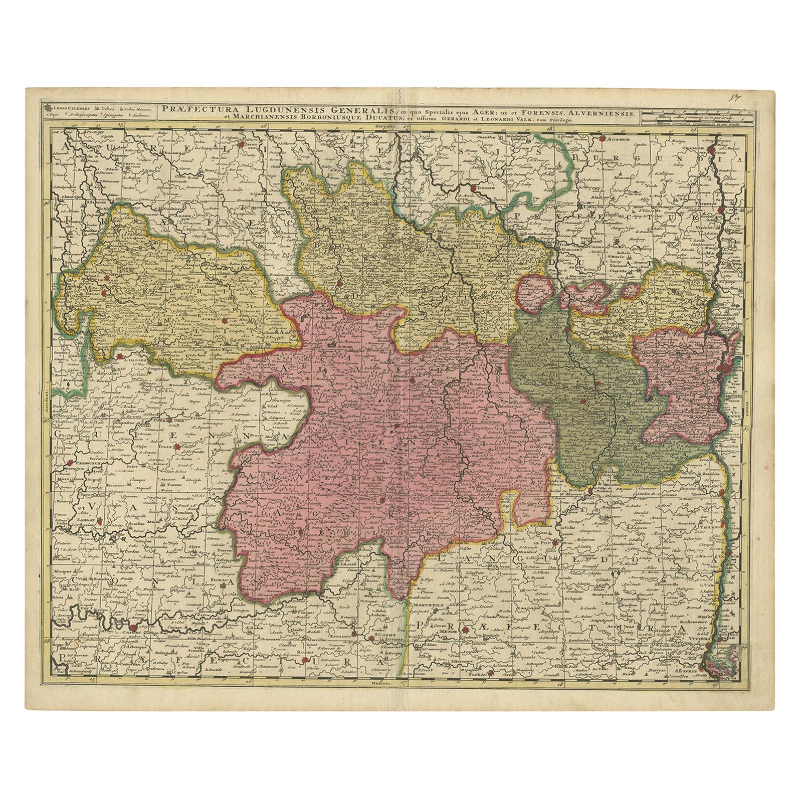
Antique Map of the Auvergne-Rhône-Alpes region of France by Valk, circa 1730
Located in Langweer, NL
Antique map titled 'Praefectura Lugdunensis Generalis'. Detailed map of the Auvergne-Rhône-Alpes region in the southeast of France. To the east the Rhône from Chalon-sur-Saône, Mâcon...
Category
Antique Mid-18th Century Maps
Materials
Paper
$465 Sale Price
20% Off
Antique Map of the Lorraine Region 'France' (c.1735)
Located in Langweer, NL
Antique map titled 'Carte du Duche de Lorraine - Kaart van Lotharingen'. A detailed map of the Duchy of Lorraine. The map is surrounded by thirteen vignette bird-eye view of fortifie...
Category
Antique Mid-18th Century Maps
Materials
Paper

$256 Sale Price
20% Off
You May Also Like
1771 Bonne Map of Poitou, Touraine and Anjou, France, Ric.a015
Located in Norton, MA
1771 Bonne Map of Poitou,
Touraine and Anjou, France
Ric.a015
1771 Bonne map of Potiou, Touraine and Anjou entitled "Carte des Gouvernements D'Anjou et du Saumurois, de la Touraine, du Poitou,du Pays d'aunis, Saintonge?Angoumois,"
Carte des gouvernements d'Anjou et du Saumurois, de la Touraine, du Poitou, du Pays d'Aunis, Saintonge-Angoumois. Projettee et assujettie au ciel par M. Bonne, Hyd. du Roi. A Paris, Chez Lattre, rue St. Jacques a la Ville de Bord(ea)ux. Avec priv. du Roi. 1771. Arrivet inv. & sculp., Atlas moderne ou collection de cartes sur toutes...
Category
Antique 17th Century Unknown Maps
Materials
Paper

Antique French Map of Asia Including China Indoneseia India, 1783
Located in Amsterdam, Noord Holland
Very nice map of Asia. 1783 Dedie au Roy.
Additional information:
Country of Manufacturing: Europe
Period: 18th century Qing (1661 - 1912)
Condition: Overall Condition B (Good Used)...
Category
Antique 18th Century European Maps
Materials
Paper

$648 Sale Price
20% Off
Original Large Antique Map of Paris, France by John Dower, 1861
Located in St Annes, Lancashire
Fabulous monochrome map of Paris.
Vignettes of St Germain En Laye, Saint Cloud, Versailles and Fontainbleau.
Unframed.
Drawn by J.Dower.
Lithography by Weller. 4 sheets joined to...
Category
Antique 1860s English Victorian Maps
Materials
Paper

18th Century Hand-Colored Homann Map of Germany, Including Frankfurt and Berlin
By Johann Baptist Homann
Located in Alamo, CA
An 18th century hand-colored map entitled "Tabula Marchionatus Brandenburgici et Ducatus Pomeraniae quae sunt Pars Septentrionalis Circuli Saxoniae Superioris" by Johann Baptist Homa...
Category
Antique Early 18th Century German Maps
Materials
Paper

1790 Thomas Stackhouse Map, Entitled "Russia in Europe, " , Ric.a004
Located in Norton, MA
1790 Thomas Stackhouse map, entitled
"Russia in Europe"
Ric.a004
Stackhouse, Thomas
Russia in Europe [map]
London: T. Stackhouse, 1783. Map. Matted hand-colored copper engraving. Image size: 14.5 x 15.25 inches. Mat size: 22.75 x 23.75 inches. A beautiful example of this map of Eastern Europe...
Category
Antique 17th Century Unknown Maps
Materials
Paper

1640 Joan Bleau Map Entitled"Diocecese de rheims et le pais de rethel, " Eic.a011
Located in Norton, MA
1640 Joan Bleau map entitled
"Diocecese de rheims et le pais de rethel,"
Ric.a011
OAN BLAEU
Diocecese de Rheims, et le pais de Rethel.
Handcolored engraving, c.1640.
...
Category
Antique 17th Century Dutch Maps
Materials
Paper

More Ways To Browse
Large Wall Maps
Iraq Map
Mughal Map
Map Of Palestine
Victorian Portico
Antique Furniture Dundee
Antique Map Iceland
Antique Maps Of Malta
Antique Saudi Arabia
Otto Petri
Serbia Antique Map
Taiwan Map
Antique Maps Colorado
Antique Wooden Roller
Hemisphere Antiques
Map Of Jamaica
Raleigh Antique Furniture
Antique Map Of Colombia