Items Similar to Antique Map of the Rhineland and Lotharingen by Tirion, c.1740


Want more images or videos?
Request additional images or videos from the seller
1 of 5
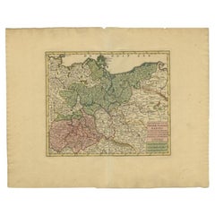
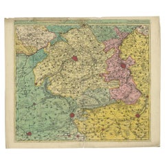
Antique Map of the Rhineland and Lotharingen by Tirion, c.1740
$261.67
$327.0920% Off
£194.76
£243.4520% Off
€218.40
€27320% Off
CA$358.43
CA$448.0420% Off
A$398.65
A$498.3120% Off
CHF 208.16
CHF 260.2020% Off
MX$4,851.16
MX$6,063.9520% Off
NOK 2,658.56
NOK 3,323.2020% Off
SEK 2,493.26
SEK 3,116.5820% Off
DKK 1,662.60
DKK 2,078.2520% Off
Shipping
Retrieving quote...The 1stDibs Promise:
Authenticity Guarantee,
Money-Back Guarantee,
24-Hour Cancellation
About the Item
Antique map titled 'Nieuwe Kaart van de Opper en Neder Rhynse Kreits nevens het Hertogdom Lotharingen.' Attractive detailed map showing the Rheinland (Rhineland) and Lotharingen, Germany and France. Source unknown, to be determined.
Artists and Engravers: Isaak Tirion, a Dutch publisher in Amsterdam, was born 1705. He produced serveral Atlases and Dutch town plans. The maps mainly based on those of Guillaume de l'Isle. He died in 1765.
Condition: Good, given age. Edges with small tears. Light soiling and some spots in the margins. Original middle fold as issued. General age-related toning and/or occasional minor defects from handling. Please study image carefully.
Date: c.1740
Overall size: 55 x 43.5 cm.
Image size: 33 x 28.2 cm.
We sell original antique maps to collectors, historians, educators and interior decorators all over the world. Our collection includes a wide range of authentic antique maps from the 16th to the 20th centuries. Buying and collecting antique maps is a tradition that goes back hundreds of years. Antique maps have proved a richly rewarding investment over the past decade, thanks to a growing appreciation of their unique historical appeal. Today the decorative qualities of antique maps are widely recognized by interior designers who appreciate their beauty and design flexibility. Depending on the individual map, presentation, and context, a rare or antique map can be modern, traditional, abstract, figurative, serious or whimsical. We offer a wide range of authentic antique maps for any budget.
- Creator:Isaak Tirion (Artist)
- Dimensions:Height: 17.13 in (43.5 cm)Width: 21.66 in (55 cm)Depth: 0 in (0.01 mm)
- Materials and Techniques:
- Period:
- Date of Manufacture:circa 1740
- Condition:
- Seller Location:Langweer, NL
- Reference Number:Seller: PCT-592171stDibs: LU3054327912762
About the Seller
5.0
Recognized Seller
These prestigious sellers are industry leaders and represent the highest echelon for item quality and design.
Platinum Seller
Premium sellers with a 4.7+ rating and 24-hour response times
Established in 2009
1stDibs seller since 2017
2,508 sales on 1stDibs
Typical response time: <1 hour
- ShippingRetrieving quote...Shipping from: Langweer, Netherlands
- Return Policy
Authenticity Guarantee
In the unlikely event there’s an issue with an item’s authenticity, contact us within 1 year for a full refund. DetailsMoney-Back Guarantee
If your item is not as described, is damaged in transit, or does not arrive, contact us within 7 days for a full refund. Details24-Hour Cancellation
You have a 24-hour grace period in which to reconsider your purchase, with no questions asked.Vetted Professional Sellers
Our world-class sellers must adhere to strict standards for service and quality, maintaining the integrity of our listings.Price-Match Guarantee
If you find that a seller listed the same item for a lower price elsewhere, we’ll match it.Trusted Global Delivery
Our best-in-class carrier network provides specialized shipping options worldwide, including custom delivery.More From This Seller
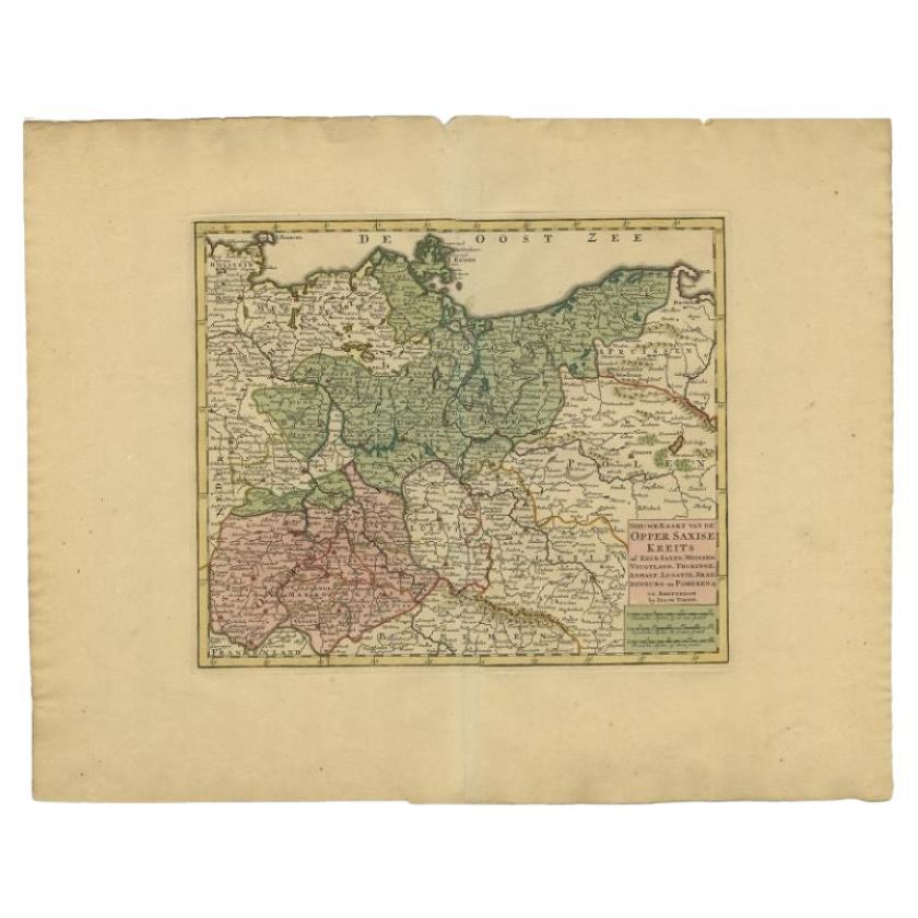
View AllAntique Map of Upper Saxony in Germany by Tirion, circa 1740
By Isaak Tirion
Located in Langweer, NL
Antique map titled 'Nieuwe Kaart van de Opper Saxise Kreits (..).' Attractive detailed map showing Upper Saxony, Germany with Meissen, Thuringen, Anhalt, Brandenburg, Pommeren etc. S...
Category
Antique 18th Century Maps
Materials
Paper
$460 Sale Price
20% Off
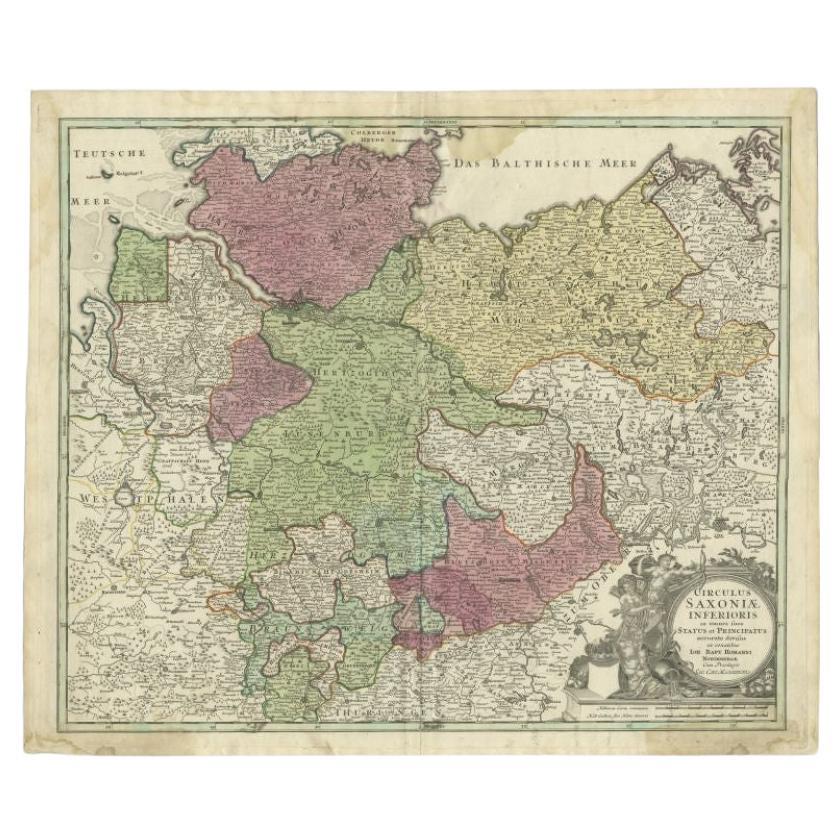
Antique Map of the Lower Saxony Region by Homann, c.1730
By Johann Baptist Homann
Located in Langweer, NL
Antique map titled 'Circulus Saxoniae Inferioris (..)'. Map of the Circle of Lower Saxony. The map covers most of present-day northern Germany, as far south as Göttingen, including m...
Category
Antique 18th Century Maps
Materials
Paper

$181 Sale Price
20% Off
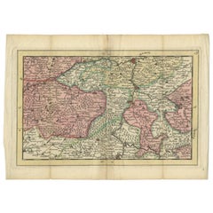
Antique Map of Lower Saxony in Germany, c.1740
Located in Langweer, NL
Antique map titled 'Nieuwe Kaart van de Neder Saxise Kreits (..).' Attractive detailed map showing Lower Saxony, Germany, including Mekelenburg, Lauwenburg, Holstein, Bremen, Verden ...
Category
Antique 18th Century Maps
Materials
Paper

$527 Sale Price
20% Off
Antique Map of the Rhine and Moselle River Region in Germany and France, c.1680
Located in Langweer, NL
Antique map titled 'Tabula Geographica qui Pars Meridionalis sive Superior Rheni, Mosae et Mosellae (..).'
Detailed map of the Rhine and Moselle River regions and contigous parts...
Category
Antique 17th Century Maps
Materials
Paper

$527 Sale Price
20% Off
Antique Map of the Region of Namur by De Lat, 1737
Located in Langweer, NL
Untitled map of the region of Namur, Charlemont, Rochefort and surroundings, Belgium. This map originates from 'Nieuw en beknopt Kaart-Boekje vertoonende de XVII. Nederlandse Provint...
Category
Antique 18th Century Maps
Materials
Paper
$122 Sale Price
20% Off
Antique Map of Flanders, France Incl the Cities Lille, Tournai, Douai, c.1730
Located in Langweer, NL
Antique map titled 'Flandriae comitatus pars Australis'. Decorative antique map of the southern portion of Flanders, France. It shows the cities of Lille (Rijsel), Douai, Tournai (Do...
Category
Antique 18th Century Maps
Materials
Paper
$455 Sale Price
20% Off
You May Also Like
1752 Vaugoundy Map of Flanders : Belgium, France, and the Netherlands, Ric.a002
Located in Norton, MA
Large Vaugoundy Map of Flanders:
Belgium, France, and the Netherlands
Colored -1752
Ric.a002
Description: This is a 1752 Didier Robert de Vaugondy map of Flanders. The map de...
Category
Antique 17th Century Unknown Maps
Materials
Paper

18th Century Hand-Colored Homann Map of Germany, Including Frankfurt and Berlin
By Johann Baptist Homann
Located in Alamo, CA
An 18th century hand-colored map entitled "Tabula Marchionatus Brandenburgici et Ducatus Pomeraniae quae sunt Pars Septentrionalis Circuli Saxoniae Superioris" by Johann Baptist Homa...
Category
Antique Early 18th Century German Maps
Materials
Paper

17th Century Hand-Colored Map of a Region in West Germany by Janssonius
By Johannes Janssonius
Located in Alamo, CA
This attractive highly detailed 17th century original hand-colored map is entitled "Archiepiscopatus Maghdeburgensis et Anhaltinus Ducatus cum terris adjacentibus". It was published ...
Category
Antique Mid-17th Century Dutch Maps
Materials
Paper

17th Century Hand Colored Map of the Liege Region in Belgium by Visscher
By Nicolaes Visscher II
Located in Alamo, CA
An original 17th century map entitled "Leodiensis Episcopatus in omnes Subjacentes Provincias distincté divisusVisscher, Leodiensis Episcopatus" by Nicolaes Visscher II, published in Amsterdam in 1688. The map is centered on Liege, Belgium, includes the area between Antwerp, Turnhout, Roermond, Cologne, Trier and Dinant.
This attractive map is presented in a cream-colored mat measuring 30" wide x 27.5" high. There is a central fold, as issued. There is minimal spotting in the upper margin and a tiny spot in the right lower margin, which are under the mat. The map is otherwise in excellent condition.
The Visscher family were one of the great cartographic families of the 17th century. Begun by Claes Jansz Visscher...
Category
Antique Late 17th Century Dutch Maps
Materials
Paper

1839 Map of Karte Des "Russischen Reiches in Europa Und Asien" Ric.R0013
Located in Norton, MA
1839 map of Karte Des
"Russischen Reiches in Europa and Asien"
Ric.r013
Map of the European and Asian parts of Russian Empire. Karte der Russischen Reiches in Europa und Asien...
Category
Antique 19th Century Unknown Maps
Materials
Paper

1640 Joan Bleau Map Entitled"Diocecese de rheims et le pais de rethel, " Eic.a011
Located in Norton, MA
1640 Joan Bleau map entitled
"Diocecese de rheims et le pais de rethel,"
Ric.a011
OAN BLAEU
Diocecese de Rheims, et le pais de Rethel.
Handcolored engraving, c.1640.
...
Category
Antique 17th Century Dutch Maps
Materials
Paper

More Ways To Browse
Antique Map Of Colombia
Antique Map Palestine
Vintage Wooden Roller
Antique Constellation Map
Antique Maps Of Cape Of Good Hope
Caucasus Map
Map Of Puerto Rico
Nevada Antique Map
Shetland Map
Antique Chicago Maps
Kolkata Antique Furniture
Antique Bermuda Furniture
Antique Dairy Collectibles
Antique Map Of Cuba
Antique Map Of Yorkshire
Antique Map Vietnam
Antique Maps Massachusetts
Guyana Antique Map